During the fall of 2010, a transition from an El Nino event to a La Nina event took place, with a moderate to strong La Nina developing during the winter of 2010-2011. As we headed into the winter months of 2011-2012...La Nina conditions returned to the equatorial Pacific Ocean for the second straight winter. The Climate Prediction Center (CPC) has issued the official winter outlook for the United States. So what will this mean for our area of Northern Indiana, Southwest Lower Michigan and Northwest Ohio? Read below for more information...
La Nina refers to the periodic cooling of ocean surface temperatures in the central and east-central equatorial Pacific. Typically, La Nina events occur every 3 to 5 years or so, but on occasion can occur over successive years. La Nina represents the cool phase of the El Nino/Southern Oscillation (ENSO) cycle. La Nina weakened last spring into early summer but began to show signs of strengthening again late this summer as negative temperature anomalies returned to the equatorial Pacific Ocean. Several computer models forecast this cooling to continue through the winter and therefore the latest official forecast from the Climate Prediction Center (CPC) calls for this La Nina to strengthen and persist into the early Spring of 2012.
During a La Nina event, the changes in Pacific Ocean temperatures affect the patterns of tropical rainfall from Indonesia to the west coast of South America. These changes in tropical rainfall patterns affect weather patterns throughout the world. These effects are usually strongest during the winter months when the jet stream is strongest over the United States. As shown in the image below, La Nina episodes in the winter months feature a wave-like jet stream flow across the United States and Canada, which causes colder and stormier than average conditions across the North, and warmer and less stormier conditions across the south. Historically for this part of the Midwest, fall tends to be warmer and drier than normal while winters tend to be wetter than normal. However, there are also many other complicated factors in the atmosphere and oceans that can also impact our weather patterns.

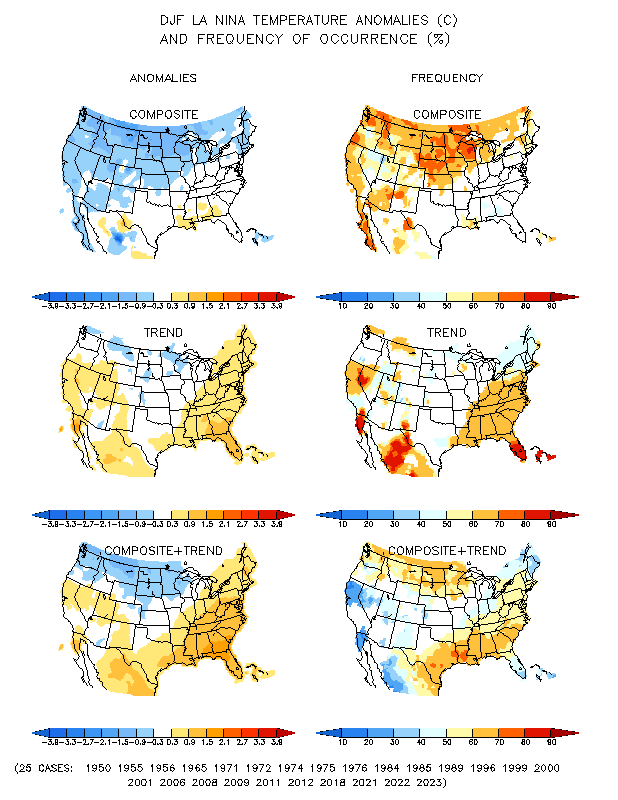
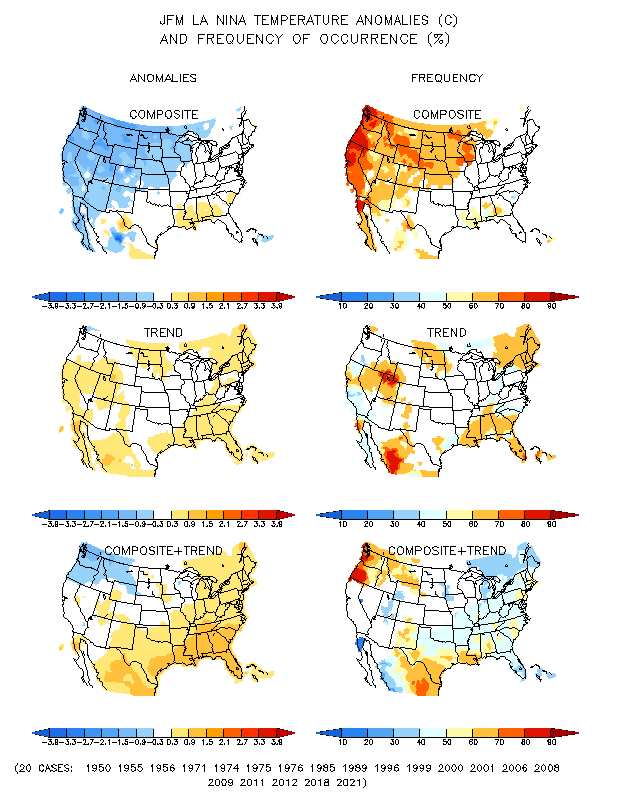
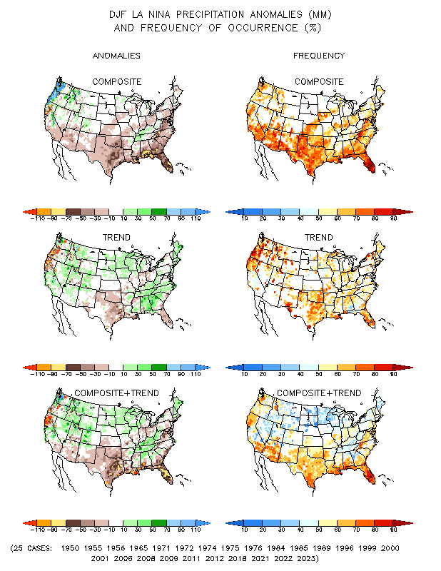
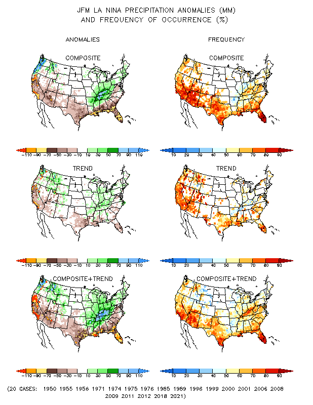
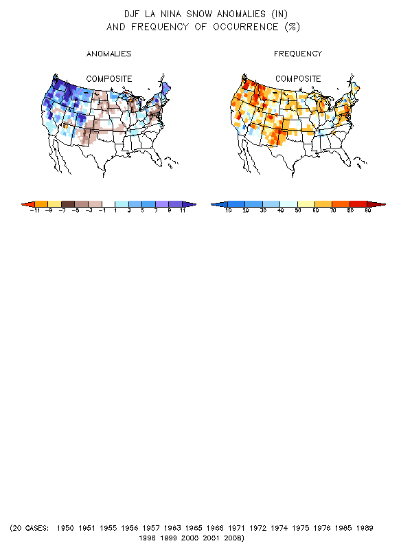
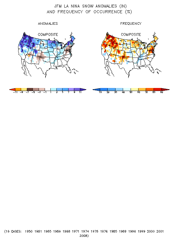
The images below show temperature, precipitation and snowfall anomalies across the continental United States (CONUS) based on past La Nina events dating back to 1950. Each image is comprised of an anomaly map on the left side and a frequency map on the right. The anomaly map shows the computed anomaly based on all past events. The frequency map on the right indicates how often these anomalies occurred. A high frequency leads to a higher confidence that the anomaly may occur again. The maps are further broke down by composite on the top, trends in the middle, and a combination of composite and trends on the bottom. A more detailed explanation of these maps can be found at here . The images on the left are for the period December-February (meteorological winter), and the images on the far right are for the January-March period (late winter into early spring). For our area, you can see that the temperature anomalies are close to zero, but the negative anomalies are just to our northwest. This is a reflection of some La Nina years being warmer than normal and others being colder than normal. Precipitation and snowfall anomalies for our area become wetter as we progress through the winter into the early spring, with a decent frequency of occurrence. Remember, these maps are based on past La Nina events alone and do not take into account other phenomena which can work with or against a La Nina pattern and impact our weather. A couple of the more well know phenomena are described in the following sections.
 |
 |
 |
 |
 |
 |
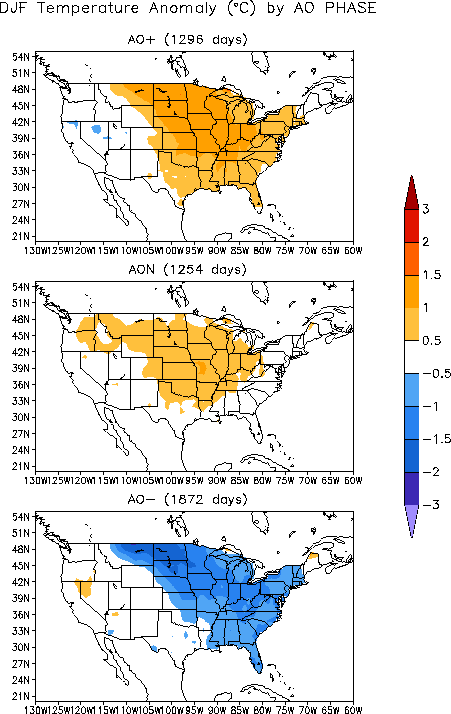
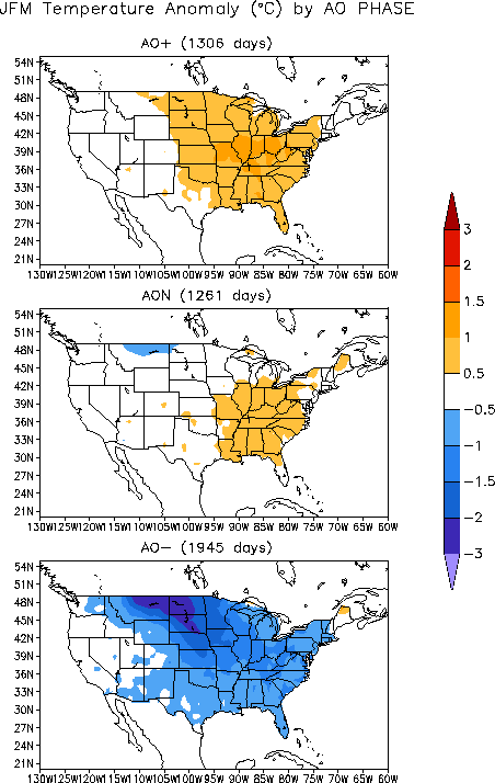
The AO is a reference to changing atmospheric pressure patterns in the high latitudes of the Arctic region. When there is relatively high pressure over the northern polar region and relatively low pressure in the middle latitudes, the AO is considered to be in a negative phase. When this pattern is reversed, it is known to be in a positive phase. During the negative phase, cold air generally plunges southward into the central and eastern United States as the jetstream buckles and high pressure over the polar region helps push the very cold polar air southward. In the positive phase, the winds associated with the polar jet stream are generally zonal and confined to the northern latitudes. This essentially "bottles up" the very cold air in the polar regions. The AO phases can be seen in the diagram below. Additional information on the AO can be found at http://www.cpc.ncep.noaa.gov/products/precip/CWlink/daily_ao_index/ao.shtml .
 |
The NAO is similar to the AO, but is a measure of the difference in atmospheric sea level pressure between the Icelandic low (also known as the polar low) and the Azores high (also known as the subtropical high). The positive phase of the NAO indicates a stronger than normal Azores high and a stronger than normal Icelandic low. This results in an increased pressure gradient between the two. The negative phase of the NAO indicates a weaker Azores high and weaker Icelandic low, which results in a weaker pressure gradient between the two pressure centers. The positive phase is generally associated with above average temperatures in the eastern CONUS while the negative phase is associated with below average temperatures. The NAO phases can be seen in the diagram below. Additional information on the NAO can be found here
 |
While the AO and NAO have been shown to have significant impacts on the weather across the CONUS, they can only be forecast with reasonable skill out to about two weeks. Therefore, while La Nina is a persistent, relatively long term pattern, the AO and NAO fluctuations are on a much smaller time scale and their effects can enhance or suppress conditions typically associated with a La Nina. When the AO and NAO are in their negative phases, they can provide cold air across the CONUS. If these phases coincide with a strong storm system generated in a La Nina pattern, a significant snow storm could be the result. However, if the AO and NAO are in a positive phase when a storm system develops, there could be less cold air and potentially more liquid precipitation. These complicated interactions are just a small part of what makes forecasting winter weather in the central and eastern United States so difficult.
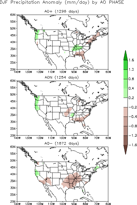
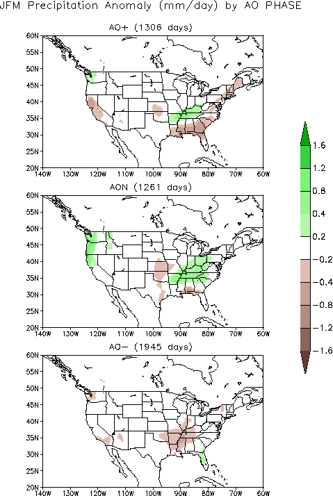
The images below show temperature and precipitation anomalies typically associated with the AO positive phase (AO+), neutral phase (AON), and negative phase (AO-) across the CONUS. The images on the left side are for the December-February period and the images on the right show the January-March period. You can see that when the AO is positive, a large part of the central and eastern CONUS experiences positive temperature anomalies. When the AO is negative, many of these same areas have negative temperature anomalies. Impacts on precipitation are not as widespread as temperatures, but there is a trend toward less precipitation in a negative AO pattern in areas where La Nina tends to produce above normal precipitation, specifically in the Ohio and Lower Mississippi Valley regions. These opposite patterns help fuel the uncertainty when forecasting winter precipitation. However, La Nina systems are usually very strong and moisture rich and tend to overcome the negative precipitation anomalies associated with the negative AO in our area.
 |
 |
 |
 |
The map below shows the conditions typically associated with the NAO.
 |
The experts at the Climate Prediction Center (CPC) provide temperature and precipitation outlooks on weekly, monthly, and seasonal timescales using data sets, computer models, and other research tools. Pictured below are the current outlooks for this Winter (December, January, and February). The current winter outlook shows equal chance for normal or above or below normal temperatures as well as increased chances for above normal precipitation for Northern Indiana, Southwest Lower Michigan and Northwest Ohio. It is important to remember that these maps show probabilities for these conditions to occur and do not imply certainty. Also, the precipitation map is not an indicator of snow chances or amounts, but simply precipitation in general. As explained in previous sections, if the AO or NAO become positive for a long period, that could lead to a milder winter in the northern CONUS. However, If they become negative for a long period, that could mean a very cold winter for the north. These indices have been negative for the last several winters and some research suggest these indices may stay in overall negative or positive phases for several years at a time. We must also remember that storm development and tracks through the midwest are critical in the winter for determining where the heaviest precipitation will occur and in what form it will fall. La Nina tends to shift storm tracks a little further south compared to normal, with the Ohio River Valley region being a favored area for winter storms. This places our region on the very northern edge of many winter storms.
Winter (December through February) Temperature and Precipitation Outlook issued November 17th
 |
 |
After looking at research based on a national scale and the CPC's winter outlook, a local research study was completed to look at how past La Nina events affected the local area. Since 1950, there have been 14 documented La Nina episodes. Because of a limited dataset and local climate variability, these results alone cannot predict exactly what will happen during the current La Nina episode, but it is interesting to note the trends. Monthly average temperatures, precipitation, and snowfall data for each episode was compiled for Fort Wayne and South Bend. The graphs that follow show the departure from normal of all the La Nina episodes combined.
In general, Fort Wayne was warmer than normal for all months except March, May, and November which were colder than normal during La Nina episodes. In terms of precipitation, the months of January, February, May, August, and October were wetter than normal while the remaining months were drier than normal. Snowfall was below normal for the months of January, February, April and October-December and above normal in March.
 |
 |
 |
| Average Temperatures | Precipitation | Snowfall |
In general, South Bend was warmer than normal for all months except February, March, and May which were colder than normal during La Nina episodes. In terms of precipitation, the months of January, February, April, August, and October were wetter than normal while the remaining months were drier than normal. Snowfall was below normal for the months of January, February, November, and December and above normal in March, May and October.
 |
 |
 |
| Average Temperatures | Precipitation | Snowfall |
Check back each month as monthly averages from the current La Nina episode will be added to the graphs!
The 2010-2011 winter season was cooler and drier than normal but snowfall was above normal at both Fort Wayne and South Bend as a moderate to strong La Nina episode was occuring. The 2010-2011 winter proves why you cannot use forecasts of precipitation to imply potential snowfall amounts.
Fort Wayne --- All three months, December-February, featured below normal temperatures at Fort Wayne. The average temperature was 5.3 degrees F below normal for December, 3.1 degrees below normal for January, and 1.8 degrees below normal for February. This puts the winter season average temperature 3.4 degrees below normal. Precipitation was also below normal for both December and January (1.69" below in December and 0.25" below in January). February featured above normal precipitation (1.27" above normal). For the winter season, precipitation was below normal by 0.67". While precipitation was below normal, snowfall was above normal for all 3 months. Snowfall was 2.6 inches above normal in December and 6.2 inches above normal in January. February ended as the 2nd snowiest February on record with 18.3 inches (10.7 inches above normal)! The seasonal snowfall total of 45.3 inches was 19.5 inches above normal and the third snowiest winter season on record.
South Bend --- All three months, December-February, featured below normal temperatures at South Bend. The average temperature was 4 degrees below normal for December, 2.2 degrees below normal for January, and 1.7 degrees below normal for February. The winter season average was 2.7 degrees below normal. Precipitation was also below normal for both December (1.25" below normal) and Janauary (0.11" below normal). February featured above normal precipitation (1.53" above normal). The winter season total precipitation was 0.17 inches below normal. While precipitation was below normal, snowfall was above normal for all 3 months. Snowfall was 4.4 inches above normal in December. January snowfall totaled 53.8 inches which was 30.6 inches above normal! This makes it the second snowiest January on record behind January 1978. Snowfall for February was 10.0 inches above normal. The seasonal snowfall total of 102.9 inches was 45.0 inches above normal, making this winter the second snowiest winter season on record! There have only been two other winter seasons (1977-78 and 1981-82) that have had 100 or more inches of snow.
Through February 25th, the 2011-2012 winter season was warmer and wetter than normal but had below normal snowfall at both Fort Wayne and South Bend as a weak to moderate La Nina episode was occuring. Like the previous winter, the 2011-2012 winter proves why you cannot use forecasts of precipitation to imply potential snowfall amounts.
Fort Wayne (through February 25) --- All three months, December-February, featured above normal temperatures at Fort Wayne. The average temperature was 6.0 degrees F above normal for December, 4.7 degrees above normal for January, and 4.6 degrees above normal so far for February. This puts the winter season average temperature 4.0 degrees above normal. Precipitation was also above normal for both December and January (1.00" above in December and 0.83" above in January). So far, February has featured below normal precipitation (0.35" below normal). For the winter season, precipitation was above normal by 1.48". Snowfall was below normal for December (1.9" below normal) and February (0.7" below normal) and above normal for January (4.5" above normal). The seasonal snowfall total as of February 25th was 27.5 inches which is 1.2 inches above normal.
South Bend (through February 25) --- All three months, December-February, featured above normal temperatures at South Bend. The average temperature was 6.3 degrees above normal for December, 5.0 degrees above normal for January, and 4.0 degrees above normal for February so far. The winter season average was 5.0 degrees above normal. Precipitation was also above normal for both December (0.01" above normal) and Janauary (0.68" above normal). February so far has featured below normal precipitation (0.24" below normal). The winter season total precipitation was 0.45 inches above normal. While precipitation was above normal, snowfall was below normal for December and February and above normal in January. Snowfall was 11.6 inches below normal in December, 14.4 inches above normal in January and 4.7 inches below normal so far for February. The seasonal snowfall total of 49.7 inches was 3.2 inches below normal.
So if La Nina conditions were occurring during each of the last two winters, why is this winter so drastically different from last winter? While causes for the differences are hard to pinpoint exactly, the difference may lie in the Arctic Oscillation (AO) and the North Atlantic Oscillation (NAO) which were discussed earlier. When the AO and NAO are in their negative phases, they can provide cold air across the CONUS. If these phases coincide with a strong storm system generated in a La Nina pattern, a significant snow storm could be the result. However, if the AO and NAO are in a positive phase when a storm system develops, there could be less cold air and potentially more liquid precipitation. This has been the cause with the current winter with the cold air bottled up in northern Canada. Last winter the AO and NAO were in a negative phase which allowed the cold air to infiltrate the region and cause more snowfall instead of liquid precipitation.
Story compiled by:
Courtney Obergfell
Sam Lashley
Updated 2/26/2012


 Follow us on YouTube