

WfHC - cover page (not to be used with pre-printed report ... - CSIRO
WfHC - cover page (not to be used with pre-printed report ... - CSIRO
WfHC - cover page (not to be used with pre-printed report ... - CSIRO

You also want an ePaper? Increase the reach of your titles
YUMPU automatically turns print PDFs into web optimized ePapers that Google loves.
T<br />
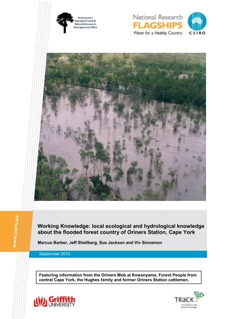
Working Knowledge: local ecological and hydrological knowledge<br />
about the flooded forest country of Oriners Station, Cape York<br />
Marcus Bar<strong>be</strong>r, Jeff Shell<strong>be</strong>rg, Sue Jackson and Viv Sinnamon<br />
Septem<strong>be</strong>r 2012<br />
Featuring information from the Oriners Mob at Kowanyama, Forest People from<br />
central Cape York, the Hughes family and former Oriners Station cattlemen.
Water for a Healthy Country Flagship Report<br />
Australia is founding its future on science and innovation. Its national science agency, <strong>CSIRO</strong>, is a<br />
powerhouse of ideas, technologies and skills.<br />
<strong>CSIRO</strong> initiated the National Research Flagships <strong>to</strong> address Australia‟s major research challenges<br />
and opportunities. They apply large scale, long term, multidisciplinary science and aim for wides<strong>pre</strong>ad<br />
adoption of solutions. The Flagship Collaboration Fund supports the <strong>be</strong>st and brightest researchers <strong>to</strong><br />
address these complex challenges through partnerships <strong>be</strong>tween <strong>CSIRO</strong>, universities, research<br />
agencies and industry.<br />
The Water for a Healthy Country Flagship aims <strong>to</strong> provide Australia <strong>with</strong> solutions for water resource<br />
management, creating economic gains of $3 billion per annum by 2030, while protecting or res<strong>to</strong>ring<br />
our major water ecosystems. The work contained in this <strong>report</strong> is collaboration <strong>be</strong>tween <strong>CSIRO</strong>, the<br />
National Water Commission, and the Department of Sustainability, Environment, Water, Population<br />
and Communities.<br />
For more information about Water for a Healthy Country Flagship or the National Research Flagship<br />
Initiative visit www.csiro.au/org/HealthyCountry.html<br />
Citation: Bar<strong>be</strong>r, M., Shell<strong>be</strong>rg, J., Jackson, S and Sinnamon, V. (2012). Working<br />
Knowledge: local ecological and hydrological knowledge about the flooded forest country of<br />
Oriners Station, Cape York. <strong>CSIRO</strong>, Darwin.<br />
ISBN: 978-0-643-108851 (WEB)<br />
Copyright and Disclaimer:<br />
© 2012 <strong>CSIRO</strong> To the extent permitted by law, all rights are reserved and no part of this publication<br />
<strong>cover</strong>ed by copyright may <strong>be</strong> reproduced or copied in any form or by any means except <strong>with</strong> the<br />
written permission of <strong>CSIRO</strong>.<br />
Important Disclaimer:<br />
<strong>CSIRO</strong> advises that the information contained in this publication comprises general statements based<br />
on scientific research. The reader is advised and needs <strong>to</strong> <strong>be</strong> aware that such information may <strong>be</strong><br />
incomplete or unable <strong>to</strong> <strong>be</strong> <strong>used</strong> in any specific situation. No reliance or actions must therefore <strong>be</strong><br />
made on that information <strong>with</strong>out seeking prior expert professional, scientific and technical advice. To<br />
the extent permitted by law, <strong>CSIRO</strong> (including its employees and consultants) excludes all liability <strong>to</strong><br />
any person for any consequences, including but <strong>not</strong> limited <strong>to</strong> all losses, damages, costs, expenses<br />
and any other compensation, arising directly or indirectly from using this publication (in part or in<br />
whole) and any information or material contained in it.<br />
This <strong>report</strong> was jointly funded and published by the National Water Commission and the Department<br />
of Sustainability, Environment, Water, Population and Communities. The views and opinions<br />
ex<strong>pre</strong>ssed in this publication are those of the authors and do <strong>not</strong> necessarily reflect those of the<br />
Australian Government or the Minister for Sustainability, Environment, Water, Population and<br />
Communities. While reasonable efforts have <strong>be</strong>en made <strong>to</strong> ensure that the contents of this publication<br />
are factually correct, the Commonwealth does <strong>not</strong> accept responsibility for the accuracy or<br />
completeness of the contents, and shall <strong>not</strong> <strong>be</strong> liable for any loss or damage that may <strong>be</strong> occasioned<br />
directly or indirectly through the use of, or reliance on, the contents of this publication.<br />
Enquiries:<br />
Dr Marcus Bar<strong>be</strong>r<br />
<strong>CSIRO</strong> Ecosystem Sciences<br />
PMB 44 Winnellie NT 0822<br />
Phone: 08 8944 8420<br />
Email: Marcus.Bar<strong>be</strong>r@csiro.au<br />
Cover Pho<strong>to</strong>graph: Eight Mile Creek in flood. Image © KALNRMO. Unless otherwise indicated, all<br />
figures and pho<strong>to</strong>graphs in this <strong>report</strong> are © 2012 <strong>CSIRO</strong>.<br />
Working Knowledge at Oriners Station, Cape York<br />
ii
CONTENTS<br />
Acknowledgments ..................................................................................................... xi<br />
LIst of Abbreviations ................................................................................................ xii<br />
Executive summary ................................................................................................. xiii<br />
1 Introduction ........................................................................................................ 1<br />
1.1 Working Knowledge .................................................................................................. 1<br />
1.2 Flooded forest country at Oriners Station ................................................................. 4<br />
1.3 Forest People and the Oriners Mob .......................................................................... 6<br />
1.4 Research methods and participants ......................................................................... 7<br />
1.4.1 Research methods ................................................................................................ 7<br />
1.4.2 Research participants ............................................................................................ 7<br />
1.5 Existing archival resources ....................................................................................... 8<br />
1.5.1 Introduction ............................................................................................................ 8<br />
1.5.2 Natural scientific resources.................................................................................... 9<br />
1.5.3 Cultural, linguistic, his<strong>to</strong>rical and ethnographic resources ................................... 10<br />
1.6 His<strong>to</strong>ry of Oriners Station ........................................................................................ 19<br />
1.6.1 The <strong>pre</strong>-colonial period ........................................................................................ 19<br />
1.6.2 The Hughes Family ............................................................................................. 19<br />
1.6.3 The Finches at Sef<strong>to</strong>n ......................................................................................... 21<br />
1.6.4 Indigenous cattlemen .......................................................................................... 21<br />
1.6.5 Oriners purchase and recent his<strong>to</strong>ry .................................................................... 23<br />
1.7 Oriners and the contemporary regional NRM context ............................................ 32<br />
1.8 Summary ................................................................................................................. 35<br />
2 Interview <strong>to</strong>pics and themes: environmental and landscape processes ..... 37<br />
2.1 Variability and Change ............................................................................................ 37<br />
2.1.1 Geographic variability: Oriners regional comparisons ......................................... 37<br />
2.1.2 Inter-annual variability – weather and flood levels ............................................... 44<br />
2.1.3 „This month is different‟: abnormal changes ........................................................ 45<br />
2.1.4 Seasonal signals ................................................................................................. 47<br />
2.2 Water....................................................................................................................... 49<br />
2.2.1 Rain ..................................................................................................................... 49<br />
2.2.2 Flood levels and drainage lines at Oriners .......................................................... 51<br />
2.2.3 Regional flooding- the Eight Mile and Crosbie Creeks ........................................ 57<br />
2.2.4 Permanent water and groundwater flow .............................................................. 64<br />
2.2.5 Water quality........................................................................................................ 67<br />
2.3 Native animals ........................................................................................................ 69<br />
2.3.1 Aquatic animals ................................................................................................... 69<br />
2.3.2 Birds .................................................................................................................... 72<br />
2.3.3 Native <strong>pre</strong>da<strong>to</strong>rs: dingoes .................................................................................... 75<br />
2.3.4 Wallabies ............................................................................................................. 77<br />
2.4 Introduced animals .................................................................................................. 77<br />
2.4.1 Cattle ................................................................................................................... 78<br />
2.4.2 Pigs ..................................................................................................................... 79<br />
2.4.3 Horses ................................................................................................................. 81<br />
2.4.4 Cane <strong>to</strong>ads .......................................................................................................... 82<br />
2.5 Human activity ........................................................................................................ 85<br />
2.5.1 Pre-colonial wet season residence and subsistence ........................................... 85<br />
Working Knowledge at Oriners Station, Cape York<br />
iii
2.5.2 Access, infrastructure and residence ................................................................... 86<br />
2.5.3 Bush food at Oriners ............................................................................................ 91<br />
2.5.4 Cattlemen: working connections .......................................................................... 94<br />
2.5.5 Old and new connections .................................................................................... 95<br />
2.5.6 Tourists and trespassers ..................................................................................... 98<br />
2.5.7 Resources and funding ...................................................................................... 101<br />
2.6 Landscape processes and human and animal distributions ................................. 103<br />
2.6.1 Water and animal distributions .......................................................................... 103<br />
2.6.2 Cattle mustering patterns .................................................................................. 105<br />
2.6.3 Fire regimes....................................................................................................... 109<br />
2.6.4 Erosion .............................................................................................................. 114<br />
2.7 Additional features of knowledge about Oriners ................................................... 121<br />
2.7.1 Applying „Working Knowledge‟ .......................................................................... 122<br />
2.7.2 Linguistic classifications and categories ............................................................ 123<br />
2.7.3 Correlations and causes .................................................................................... 127<br />
3 Local scientific knowledge ........................................................................... 131<br />
3.1 Introduction ........................................................................................................... 131<br />
3.2 Physical conditions ............................................................................................... 131<br />
3.2.1 Climate .............................................................................................................. 131<br />
3.2.2 Topography and drainage ................................................................................. 134<br />
3.2.3 Geology ............................................................................................................. 135<br />
3.2.4 Soils ................................................................................................................... 138<br />
3.2.5 Land systems .................................................................................................... 140<br />
3.2.6 Soil erosion ........................................................................................................ 146<br />
3.2.7 Catchment land use ........................................................................................... 146<br />
3.2.8 Surface hydrology .............................................................................................. 148<br />
3.2.9 Hydrogeology .................................................................................................... 151<br />
3.2.10 Fluvial geomorphology of the Eight Mile Creek near Oriners Lagoon ................ 153<br />
3.2.11 Gully erosion...................................................................................................... 165<br />
3.3 Biological conditions ............................................................................................. 171<br />
3.3.1 Forest <strong>cover</strong>....................................................................................................... 171<br />
3.3.2 Grass <strong>cover</strong> ....................................................................................................... 172<br />
3.3.3 Weeds ............................................................................................................... 172<br />
3.3.4 Fire timing, frequency, and distribution .............................................................. 173<br />
3.3.5 Feral animals and s<strong>to</strong>ck ..................................................................................... 177<br />
3.3.6 Native terrestrial animals ................................................................................... 178<br />
3.3.7 Native birds........................................................................................................ 179<br />
3.3.8 Native aquatic animals ...................................................................................... 179<br />
3.4 Oriners and Forest Country – a brief personal perspective .................................. 180<br />
4 Synthesis: process and relationship models .............................................. 183<br />
4.1 Models of landscape-scale ecological, hydrological, and geomorphological relations at<br />
Oriners Station ...................................................................................................... 184<br />
4.1.1 Wet season........................................................................................................ 184<br />
4.1.2 Early dry season ................................................................................................ 186<br />
4.1.3 Late dry season ................................................................................................. 188<br />
4.1.4 Comparisons and interactions across seasons ................................................. 188<br />
4.1.5 Impact of Oriners Mob residence ....................................................................... 189<br />
4.2 Models of processes affecting Oriners and Jewfish Lagoons .............................. 190<br />
4.2.1 Model Introduction ............................................................................................. 190<br />
4.2.2 Oriners Lagoon .................................................................................................. 191<br />
4.2.3 Jewfish Lagoon .................................................................................................. 192<br />
4.2.4 Other major lagoons – Mosqui<strong>to</strong> and Horseshoe .............................................. 194<br />
4.3 Water quality ......................................................................................................... 196<br />
Working Knowledge at Oriners Station, Cape York<br />
iv
5 Working knowledge: Conclusions and recommendations ......................... 197<br />
5.1 Introduction ........................................................................................................... 197<br />
5.2 Flooded forest country – key characteristics ........................................................ 198<br />
5.3 Future plans and aspirations ................................................................................ 201<br />
5.4 Recommendations for further research ................................................................ 202<br />
5.5 Conclusion ............................................................................................................ 204<br />
6 References ..................................................................................................... 205<br />
7 Glossary ......................................................................................................... 212<br />
8 Appendices .................................................................................................... 218<br />
8.1 Informed Consent Form ........................................................................................ 218<br />
8.2 Seasonal indica<strong>to</strong>r observations ........................................................................... 219<br />
8.3 Wildlife Animal Species List for the Oriners and Sef<strong>to</strong>n Area............................... 220<br />
8.4 Plant Species List for the Oriners and Sef<strong>to</strong>n Area .............................................. 225<br />
Working Knowledge at Oriners Station, Cape York<br />
v
FIGURES<br />
Figure 1. Watercourse of Eight Mile Creek. ........................................................................... xi<br />
Figure 2. Mitchell River catchment <strong>with</strong> Oriners and Sef<strong>to</strong>n Stations in the Alice River<br />
subcatchments. .......................................................................................................... xv<br />
Figure 3. Cattle stations in lower Mitchell River catchment, <strong>with</strong> outlines of Kowanyama<br />
managed lands (red) including Oriners and Sef<strong>to</strong>n Stations. ........................................ 2<br />
Figure 4. Map of the lower Eight Mile and Crosbie Creek valleys and locations of the 4 major<br />
lagoons discussed in the <strong>report</strong>: Oriners, Mosqui<strong>to</strong>, Jewfish and Crosbie. .................... 5<br />
Figure 5. Horseshoe Lagoon. ............................................................................................... 11<br />
Figure 6. Cecil Hughes in Mareeba, July 2012. .................................................................... 20<br />
Figure 7. David Hughes speaking at a Mitchell River workshop attended by KALNRMO staff<br />
during the early 1990s. Image © KALNRMO............................................................... 24<br />
Figure 8. David and Bill Hughes negotiating the sale <strong>with</strong> Kowanyama people. Image ©<br />
KALNRMO .................................................................................................................. 25<br />
Figure 9. Planning meeting at Oriners soon after the purchase. Image © KALNRMO .......... 26<br />
Figure 10. Shed construction team, Oriners station. Image © KALNRMO ............................ 27<br />
Figure 11. Cattle yards at Oriners Station. Image © KALNRMO .......................................... 28<br />
Figure 12. Oriners house during construction. Image © KALNRMO ..................................... 29<br />
Figure 13. Oriners house from the air in 2012. ..................................................................... 30<br />
Figure 14. Paddy Yam, Philip Yam, Ravin Greenwool and his son Delvin at the Oriners<br />
house in 2011. ............................................................................................................ 31<br />
Figure 15. Billabong downstream from Oriners Homestead. ................................................ 41<br />
Figure 16. Paddy Yam and Louie Native standing next <strong>to</strong> Grevillea pteridifolia in flower at<br />
Mosqui<strong>to</strong> Lagoon. ....................................................................................................... 47<br />
Figure 17. Philip Yam <strong>with</strong> woody debris wedged by flood at Eight Mile Creek. ................... 51<br />
Figure 18. Oriners homestead area in flood ©KALNMRO .................................................... 52<br />
Figure 19. Philip Yam and Louie Native talk <strong>to</strong> Jeff Shell<strong>be</strong>rg about flow patterns at Oriners.<br />
................................................................................................................................... 55<br />
Figure 20. Oriners Lagoon in flood ©. KALNRMO ................................................................ 56<br />
Figure 21. Flooded Oriners airstrip.©KALNRMO .................................................................. 56<br />
Figure 22. Flood level on trees downstream from Oriners homestead. ................................ 57<br />
Figure 23. Large Woody Debris (LWD) deposited during flood on the Eight Mile Creek. ...... 58<br />
Figure 24. Jeff Shell<strong>be</strong>rg talks <strong>with</strong> Philip Yam, Louie Native, and Viv Sinnamon about<br />
erosion and water flow along the Eight Mile Creek at Oriners. .................................... 60<br />
Figure 25. Oriners country in flood. Image © KALNRMO ..................................................... 61<br />
Figure 26. Flooded forest at Oriners. Image © KALNRMO ................................................... 61<br />
Figure 27. Mitchell catchment in flood – Errk Oykangand National Park. Image © KALNRMO<br />
................................................................................................................................... 62<br />
Figure 28. Mitchell catchment in the wet season. Image © KALNRMO ................................ 62<br />
Working Knowledge at Oriners Station, Cape York<br />
vi
Figure 29. Mitchell catchment in flood – Errk Oykangand National Park. Image © KALNRMO.<br />
................................................................................................................................... 63<br />
Figure 30. Oriners country in flood. Image © KALNRMO ..................................................... 63<br />
Figure 31. Oriners Lagoon looking upstream. ...................................................................... 66<br />
Figure 32. Pig damage at Oriners. ....................................................................................... 80<br />
Figure 33. Erosion damage at old Oriners airstrip. ............................................................... 89<br />
Figure 34. Fish from Oriners Lagoon. .................................................................................. 91<br />
Figure 35. Philip Yam talks <strong>to</strong> mo<strong>to</strong>rcycle <strong>to</strong>urists passing through Oriners ......................... 98<br />
Figure 36. Fire damage <strong>to</strong> Oriners cattle yards in the 1990s. Image © KALNRMO .............. 99<br />
Figure 37. Old s<strong>to</strong>ckman‟s quarters <strong>with</strong> eroding foundations. ........................................... 102<br />
Figure 38. Oriners station from the air looking east circa 1990, showing older road networks.<br />
Image © KALNRMO ................................................................................................. 118<br />
Figure 39. Oriners station and lagoon from the air looking west circa 2012. ....................... 118<br />
Figure 40. Oriners station and building from the air looking east circa 2012. ...................... 119<br />
Figure 41. Cleared zone for new road through Oriners. ..................................................... 120<br />
Figure 42. Giant long-armed prawn, Macrobrachium rosen<strong>be</strong>rgii (image: P. Hamil<strong>to</strong>n) ...... 123<br />
Figure 43. North Queensland yabby or redclaw, Cherax quadricarinatus (Image: P. Hamil<strong>to</strong>n)<br />
................................................................................................................................. 124<br />
Figure 44. Average monthly rainfall at Oriners Station and nearby stations <strong>with</strong> longer<br />
records of rainfall and temperature. .......................................................................... 132<br />
Figure 45. Daily rainfall <strong>to</strong>tals at Oriners Station 1963-1970. .............................................. 133<br />
Figure 46. Long-term annual WY rainfall <strong>to</strong>tals and trends at Koolatah and Musgrave. ...... 134<br />
Figure 47. Topography and drainage of the catchments surrounding Oriners and Sef<strong>to</strong>n<br />
Stations. Elevation data derived from the Shuttle Radar Topography Mission 30m pixel<br />
digital elevation model (SRTM 2000). ....................................................................... 135<br />
Figure 48. Geology of the catchments surrounding Oriners and Sef<strong>to</strong>n Stations. Note<br />
locations of abandoned mines. ................................................................................. 136<br />
Figure 49. Soils of Oriners and Sef<strong>to</strong>n Stations based on the original “Atlas of Australian<br />
Soils” (Is<strong>be</strong>ll et al. 1968; BRS 1991). ........................................................................ 140<br />
Figure 50. Land system of the forest country around Oriners/Sef<strong>to</strong>n Stations. Balurga (Ba);<br />
Mottle (Mo); Annaly (A); Cumbulla (C) (extracted from Galloway et al. 1970). ......... 140<br />
Figure 51. Balurga (Ba) land system. Extensive plains on weather terrestrial sediment; sandy<br />
red and yellow earths and uniform sandy soils; bloodwood-stringybark woodland, and<br />
some paperbark woodland. (Galloway et al. 1970). .................................................. 141<br />
Figure 52. RAAF oblique pho<strong>to</strong>graph from 1943 of the Balurga (Ba) land system near Sef<strong>to</strong>n<br />
and Oriners Stations. ................................................................................................ 142<br />
Figure 53. Mottle (Mo) land system. Extensive plains on weathered terrestrial sediments,<br />
silts<strong>to</strong>ne, and alluvium; massive earths; paperbark or bloodwood-stringybark woodland<br />
(Galloway et al. 1970). .............................................................................................. 143<br />
Figure 54. Annaly (A) land system. Lowlands on partially dissected terrestrial sediment over<br />
shale massive earths and texture-contrast soils; paperbark or bloodwood-stringybark<br />
woodland. (Galloway et al. 1970). ............................................................................ 144<br />
Working Knowledge at Oriners Station, Cape York<br />
vii
Figure 55. Cumbulla (C) land system. Alluvial plains in part actively forming and largely<br />
flooded in the wet season; texture-contrast soils; paperbark woodland (Galloway et al.<br />
1970). ....................................................................................................................... 145<br />
Figure 56. Land use map of the Mitchell catchment showing a) operating mines, abandoned<br />
mines, mine claims, proposed mines, b) distribution of major alluvial gullies, c) major<br />
paved and unpaved roads, d) existing and proposed water resource development, e)<br />
agricultural development near Dimbulah (green outline). Note the relatively sparse<br />
development in and around Oriners and Sef<strong>to</strong>n Stations. ......................................... 148<br />
Figure 57. Minimum flood inundation frequency data for Oriners and Sef<strong>to</strong>n Stations and part<br />
of the Mitchell fluvial megafan (MODIS satellite imagery, num<strong>be</strong>r of times inundated<br />
<strong>be</strong>tween 2003 and 2009; Ward et al. 2012). Major permanent water body locations and<br />
typical dry-season water clarity estimates from Landsat satellite data (1986 and 2005)<br />
are also shown (Lymburner and Burrows 2008), as are the locations of smaller<br />
intermittent palustrine wetlands are also shown in black (Queensland Department of<br />
Natural Resources (QDERM) 2010).......................................................................... 149<br />
Figure 58. Air pho<strong>to</strong>graph of a mound spring (white) areas on Oriners Station. ................. 152<br />
Figure 59.Pho<strong>to</strong>graphs of a mound spring on western Oriners Station <strong>with</strong> a) water seeping<br />
<strong>to</strong> the surface, b) fluid muds oozing <strong>to</strong> the surface under <strong>pre</strong>ssure, c) the pebble lags of<br />
gravel and ferricrete nodules on the spring surface, and d) sheet wash deposit on <strong>to</strong>p<br />
of the spring following wet season rain-fall runoff or groundwater discharge. ............ 153<br />
Figure 60. False colour satellite image (ASTER) of the river segment and landscape<br />
surrounding Oriners Station and Eight Mile Creek. Note bright red colour is riparian<br />
vegetation (mainly Melaleuca spp.) growing along Eight Mile Creek. Inset box refers <strong>to</strong><br />
air pho<strong>to</strong>graphs in Figure 64 and Figure 65. ............................................................. 154<br />
Figure 61. Digital elevation model of the river segment and landscape surrounding Oriners<br />
Station and Eight Mile Creek using the 30m pixel data from the Shuttle Radar<br />
Topography Mission (SRTM 2000). Inset box refers <strong>to</strong> air pho<strong>to</strong>graphs in Figure 64 and<br />
Figure 65. Cross-section lines refer <strong>to</strong> data in Figure 62. .......................................... 155<br />
Figure 62. Elevation cross-sections across the Eight Mile Creek Valley at Oriners, derived<br />
from the Shuttle Radar Topography Mission 30m pixel digital elevation model (SRTM<br />
2000). Cross-section locations are mapped in Figure 61. Note that 2 <strong>to</strong> 5 m fluctuations<br />
in elevation could <strong>be</strong> errors from vegetation artefacts in the data. ............................. 155<br />
Figure 63. Longitudinal profile of the Eight Mile Creek Valley from the confluence of Crosbie<br />
Creek <strong>to</strong> the headwaters derived from the Shuttle Radar Topography Mission 30m pixel<br />
digital elevation model (SRTM 2000). The Oriners segment of Eight Mile Creek is also<br />
mapped in Figure 61. ................................................................................................ 156<br />
Figure 64. 1955 Aerial Pho<strong>to</strong>graph of the Eight Mile Creek reach near Oriners Station and<br />
Lagoon. See Figure 67 for detail of inset box. ........................................................... 158<br />
Figure 65. 2004 Aerial Pho<strong>to</strong>graph of the Eight Mile Creek reach near Oriners Station and<br />
Lagoon, showing existing (<strong>pre</strong>-2004) and new road (2010) infrastructure, air strip and<br />
gully erosion problem areas. See Figure 68 for detail of inset box. ........................... 158<br />
Figure 66. Ground pho<strong>to</strong>s during July 2011 of a) Eight Mile Creek looking upstream near the<br />
main anabranch bifurcation that feeds Oriners Lagoon, <strong>not</strong>e major sand bar deposits<br />
that influence channel divergence and anabranching, b) Eight Mile Creek looking<br />
upstream <strong>be</strong>low the main anabranch bifurcation that feeds Oriners Lagoon, c) the main<br />
anabranch channel looking downstream that feeds Oriners Lagoon, and d) the smaller,<br />
most upstream, anabranch channel looking downstream that feeds Oriners Lagoon.159<br />
Figure 67. 1955 Aerial Pho<strong>to</strong>graph Oriners Station and Lagoon. Note new road in 1955. .. 162<br />
Working Knowledge at Oriners Station, Cape York<br />
viii
Figure 68. 2004 Aerial Pho<strong>to</strong>graph of Oriners Station and Lagoon, showing existing road<br />
infrastructure and gully erosion problem areas. ........................................................ 162<br />
Figure 69. Ground pho<strong>to</strong>s during July 2011 of a) a sand bar infilling the <strong>to</strong>p end of Oriners<br />
Lagoon, b) the same sand bar at distance <strong>with</strong> colonizing vegetation, c), bank erosion<br />
and adjacent sand bar along the main anabranch channel above Oriners Lagoon, d)<br />
similar anabranch bank erosion and sand splay on<strong>to</strong> the floodplain above Oriners<br />
Lagoon, e) general sheet and gully erosion along the road crossing the upper<br />
anabranch inlet <strong>to</strong> Oriners Lagoon, and f) the same eroded anabranch channel looking<br />
upstream from the road. ............................................................................................ 163<br />
Figure 70. Ground pho<strong>to</strong>s of the Oriners Lagoon outlet a) in 1997 looking north <strong>with</strong> active<br />
road across outlet and sparse woodlands and emergent Melaleuca trees on sill, b) in<br />
July 2011 looking south <strong>with</strong> denser stands of Melaleuca trees, c) in July 2011 looking<br />
upstream at eroded cut through the sill on the southern outlet, d) in July 2011 looking<br />
upstream at the southern outlet channel eroding upstream <strong>to</strong>ward the sill and cut, e) in<br />
~1990 looking upstream at the sill on the northern outlet, and f) in July 2011 looking<br />
upstream at an incipient cut that will eventually erode through the sill on the northern<br />
outlet; <strong>not</strong>e same tire hanging from tree in e and f. ................................................... 164<br />
Figure 71. Examples of alluvial gullies on lagoon banks at a) Oriners Lagoon, b) Jewfish<br />
Lagoon, c) road/track at Jewfish Lagoons feeding water in<strong>to</strong> a gully, which is the same<br />
as d) next <strong>to</strong> Jewfish Lagoon. ................................................................................... 168<br />
Figure 72. A large gully upstream of Oriners Lagoon triggered by the road crossing the<br />
lagoons inlet drainage ways. ..................................................................................... 168<br />
Figure 73. Examples of roads/tracks that have cut in<strong>to</strong> the Eight Mile floodplain creating<br />
linear alluvial gullies: a) the western road entrance <strong>to</strong> Oriners, b) the eastern entrance<br />
<strong>to</strong> Oriners, c) an intact road segment on the eastern road, d) a gullied road segment<br />
downstream of c on the eastern road, e) the gullied airplane strip at Oriners from the<br />
ground, and f) the gullied airplane strip and adjacent road/fenceline at Oriners from the<br />
air. ............................................................................................................................ 169<br />
Figure 74. Examples of potential impacts from new road construction through Oriners Station<br />
and bypassing the Oriners homestead: a) the new cleared bypass viewed from the air,<br />
b) the new cleared bypass crossing an intact swampy drainage way (dambo) viewed<br />
from the air, c) the same intact swampy drainage way (dambo) viewed from the<br />
ground, d) a similar nearby drainage way that has <strong>be</strong>en gullied from excess road<br />
runoff, e) the new bypass road clearing and initial gully erosion by subsequent wet<br />
seasons, and f) a new constructed road prism <strong>with</strong> continued delivery of road ditch<br />
sediment and concentrated water <strong>to</strong> a local creek, in addition <strong>to</strong> the s<strong>pre</strong>ad of grader<br />
grass and other weeds.............................................................................................. 170<br />
Figure 75. Annual fire frequency of all seasonal fires for the Oriners/Sef<strong>to</strong>n area <strong>be</strong>tween<br />
1997 and 2010. Dark red <strong>to</strong> purple area re<strong>pre</strong>sent frequent fires occurring 10 year out<br />
of 14 <strong>to</strong>tal. Data are from the Northern Australia Fire Information (NAFI) website<br />
(www.firenorth.org.au). ............................................................................................. 175<br />
Figure 76. Annual fire frequency of late-season fires for the Oriners/Sef<strong>to</strong>n area <strong>be</strong>tween<br />
1997 and 2010. Dark red <strong>to</strong> purple area re<strong>pre</strong>sent frequent late-season fires occurring<br />
10 year out of 14 <strong>to</strong>tal, <strong>with</strong> a similar pattern and frequency <strong>to</strong> all fires in Figure 75.<br />
Data are from the Northern Australia Fire Information (NAFI) website<br />
(www.firenorth.org.au). ............................................................................................. 175<br />
Figure 77. 1955 aerial pho<strong>to</strong>graph of the Eight Mile Creek floodplain and grassy woodlands<br />
1000m south of the Oriners Station Air Strip. Compare <strong>to</strong> Figure 78. ........................ 176<br />
Figure 78. 2004 air pho<strong>to</strong>graph of the Eight Mile Creek floodplain and grassy woodlands<br />
1000m south of the Oriners Station Airstrip. Note woodland thickening around<br />
Working Knowledge at Oriners Station, Cape York<br />
ix
vegetation corridors compared <strong>to</strong> 1955, but also <strong>not</strong>e that <strong>not</strong> all dark areas in the<br />
southwest (bot<strong>to</strong>m right) part of the pho<strong>to</strong>graph are trees, as this areas was partially<br />
burnt grassland along the road. Compare <strong>to</strong> Figure 77. ........................................... 176<br />
Figure 79. Early-dry season fire scars during 2012 for the Oriners/Sef<strong>to</strong>n area, <strong>with</strong> all fires lit<br />
by humans in a coordinated ground and air based traditional fire regime program. Data<br />
are from the Northern Australia Fire Information (NAFI) website (www.firenorth.org.au).<br />
................................................................................................................................. 177<br />
Figure 80. Model of Oriners landscape interactions in the wet season ............................... 186<br />
Figure 81. Early dry season diagram ................................................................................. 187<br />
Figure 82. Road erosion leading in<strong>to</strong> Oriners Lagoon. ....................................................... 187<br />
Figure 83. Late dry season diagram ................................................................................... 188<br />
Figure 84. Early dry season diagram- Oriners Mob residence ............................................ 189<br />
Figure 85. Erosion channel upstream from Oriners Lagoon. .............................................. 190<br />
Figure 86. Model of fac<strong>to</strong>rs affecting water volume and s<strong>to</strong>rage capacity at Oriners Lagoon.<br />
................................................................................................................................. 191<br />
Figure 87. Jewfish Lagoon looking upstream. .................................................................... 192<br />
Figure 88. The recently widened and already eroding road crossing immediately upstream of<br />
Jewfish Lagoon. ........................................................................................................ 193<br />
Figure 89. The outlet sills and channels of Jewfish Lagoon looking downstream at a) the left<br />
outlet channel and b) the right outlet channel. ........................................................... 194<br />
Figure 90. Model of fac<strong>to</strong>rs affecting water volume and s<strong>to</strong>rage capacity at Jewfish Lagoon.<br />
................................................................................................................................. 194<br />
Figure 91. Mosqui<strong>to</strong> Lagoon looking upstream................................................................... 195<br />
Figure 92. Oblique air pho<strong>to</strong>s of Horseshoe Lagoon looking East. ..................................... 196<br />
Working Knowledge at Oriners Station, Cape York<br />
x
ACKNOWLEDGMENTS<br />
The project is the result of a research partnership <strong>be</strong>tween the Kowanyama people (through<br />
the Kowanyama Aboriginal Land and Natural Resource Management Office- KALNRMO)<br />
and the Water for a Healthy Country Flagship of the <strong>CSIRO</strong>. The authors wish <strong>to</strong><br />
acknowledge the assistance of all of the Indigenous 1 and non-Indigenous research<br />
participants in this study who made the field research possible – the Oriners Mob 2 , „Forest<br />
People‟ connected <strong>to</strong> the area, the Hughes family, and Indigenous cattlemen from other<br />
places who worked at Oriners over the years.<br />
Griffith University and the Australian Rivers Institute provided logistical support for scientific<br />
participation in this project. The work <strong>report</strong>ed here follows on from other work undertaken<br />
<strong>with</strong> the KALNRMO, including collaboration <strong>with</strong> research partners from the Tropical Rivers<br />
and Coastal Knowledge Research Hub (TRaCK - www.track.gov.au).<br />
<strong>CSIRO</strong> volunteers Chloe Gibbon, Mitchell Proudfoot and Roshini Vincent assisted <strong>with</strong><br />
interview transcripts and other research tasks. Finally, the authors thank Veronica Strang for<br />
generously providing her time and expertise as an expert reviewer. Her comments assisted<br />
the concluding phase of the <strong>report</strong>‟s production and provided fruitful suggestions for further<br />
analysis.<br />
Figure 1. Watercourse of Eight Mile Creek.<br />
1 This <strong>report</strong> follows <strong>CSIRO</strong> publication convention in using „Indigenous‟, but „Aboriginal‟ will <strong>be</strong> <strong>used</strong><br />
where it is part of an organisational name or formal quotation.<br />
2 The usage of „Oriners Mob‟ and „Forest People‟ as collective terms for Indigenous people associated<br />
<strong>with</strong> the Oriners area is explained further in 1.3 of the introduction.<br />
Working Knowledge at Oriners Station, Cape York<br />
xi
LIST OF ABBREVIATIONS<br />
ASTER – Advanced Spaceborne Thermal Emission and Reflection Radiometer<br />
BMP – Best Management Practice<br />
CYPAL – Cape York Peninsula Aboriginal Land<br />
CYPLUS – Cape York Peninsula Land Use Strategy<br />
<strong>CSIRO</strong> – Commonwealth Scientific and Industrial Research Organization<br />
DERM – Department of Environment and Natural Resource Management<br />
DOGIT – Deed of Grant in Trust<br />
GPR – Ground Penetrating Radar<br />
KAC – Kowanyama Aboriginal Council<br />
KALNRMO – Kowanyama Aboriginal Land and Natural Resource Management Office<br />
LANDSAT – Land Satellite or Land Remote-Sensing Satellite<br />
LWD – Large Woody Debris<br />
LiDAR – Light Detection and Ranging<br />
MODIS – Moderate Resolution Imaging Spectroradiometer<br />
NAFI – Northern Australia Fire Information<br />
NRM – Natural Resource Management<br />
OSL – Optical Stimulated Luminescence<br />
QPWS – Queensland Parks and Wildlife Service<br />
SRTM – Shuttle Radar Topography Mission<br />
TRaCK- Tropical Rivers and Coastal Knowledge<br />
Working Knowledge at Oriners Station, Cape York<br />
xii
EXECUTIVE SUMMARY<br />
This is a <strong>report</strong> about a local ecological knowledge re<strong>cover</strong>y, documentation and modelling<br />
project in south central Cape York, Queensland, Australia. It was funded through the Water<br />
for Healthy Country Flagship of the <strong>CSIRO</strong> under an agreement <strong>be</strong>tween the <strong>CSIRO</strong> and the<br />
Kowanyama Aboriginal Land and Natural Resource Management Office (KALNRMO). The<br />
geographical focus of the project is Oriners Station (Figure 2; Figure 3) but it also contains<br />
material relevant <strong>to</strong> Sef<strong>to</strong>n station and <strong>to</strong> other Indigenous lands north of the Alice River.<br />
Oriners is an area of the Cape that is associated <strong>with</strong> Olkol speaking peoples and contains<br />
some places of considerable cultural importance. In the wet season, Oriners country<br />
periodically floods and the soils <strong>be</strong>come saturated and boggy, but these characteristics have<br />
also meant that the area is relatively undeveloped, undistur<strong>be</strong>d, and of high ecological value.<br />
From the 1940s, the Oriners area was owned and <strong>used</strong> as a cattle station by several<br />
mem<strong>be</strong>rs of the non-Indigenous Hughes family, a well-known and longstanding pas<strong>to</strong>ral<br />
family in Northern Queensland, and many of the workers on the station during this period<br />
were local Indigenous people. In the early 1990s the property was purchased from the<br />
Hughes family by the Kowanyama Council and since that time, Oriners has <strong>be</strong>en<br />
intermittently occupied by a subset of Kowanyama people (sometimes called „the Oriners<br />
Mob‟) and managed for its conservation, natural resource management (NRM) and heritage<br />
value by the KALNRMO. The key community objective has <strong>be</strong>en <strong>to</strong> get people back on<strong>to</strong> the<br />
country and this <strong>report</strong> reflects the ongoing commitment of the KALNRMO and the wider<br />
Kowanyama community <strong>to</strong> building and maintaining a socially, economically and<br />
environmentally sustainable <strong>pre</strong>sence at Oriners. Indigenous people from around the region<br />
recognise the value and distinctive characteristics of the Oriners area and want <strong>to</strong> see it<br />
managed well. For them this project is one step in that ongoing process.<br />
The <strong>report</strong> also reflects the aspirations of the Water for a Healthy Country Flagship of the<br />
<strong>CSIRO</strong>, which committed significant funds <strong>to</strong> investigating and modelling indigenous<br />
hydrological knowledge and ecological understanding at key sites in Northern Australia. This<br />
was part of the ongoing commitment of the <strong>CSIRO</strong> <strong>to</strong> appropriate research partnerships <strong>with</strong><br />
Indigenous people, particularly in the area of knowledge documentation and natural resource<br />
management.<br />
The project <strong>report</strong> collates and synthesises some key aspects of knowledge about the<br />
Oriners area. It is divided in<strong>to</strong> 5 parts. Part 1 introduces some key framing concepts for the<br />
<strong>report</strong>. The first of these is „Working Knowledge‟, which is <strong>pre</strong>ferred here <strong>to</strong> more common<br />
la<strong>be</strong>ls like „Local‟, „Indigenous‟, and/or „scientific‟. Working Knowledge is <strong>used</strong> <strong>be</strong>cause it<br />
collectively descri<strong>be</strong>s the contexts in which much of the knowledge was gained (Indigenous,<br />
pas<strong>to</strong>ral, NRM, and scientific work), the provisional and ongoing quality of that knowledge,<br />
the fact that the men offering it come from a range of backgrounds (local, Indigenous, and/or<br />
scientific) and the fact that this <strong>report</strong> is oriented <strong>to</strong>wards ongoing NRM work in the area.<br />
Other key concepts are „Oriners Mob‟, which descri<strong>be</strong>s the contemporary Indigenous people<br />
most closely associated <strong>with</strong> the station, and „flooded forest country‟, which descri<strong>be</strong>s its two<br />
major distinctive characteristics from the perspective of its Kowanyama owners. Part 1 also<br />
reviews key literature related <strong>to</strong> the area, focusing on cultural, his<strong>to</strong>rical, and linguistic<br />
sources, descri<strong>be</strong>s the fieldwork methods (primarily semi-structured interviews) and the<br />
research participants. Finally it discusses the regional and strategic significance of Oriners as<br />
both a distinctive property and a key component of a growing num<strong>be</strong>r of properties in the<br />
area more heavily oriented <strong>to</strong> Indigenous and NRM objectives than <strong>to</strong> pas<strong>to</strong>ral activities.<br />
Working Knowledge at Oriners Station, Cape York<br />
xiii
Part 2 of the <strong>report</strong> contains a synthesis of key findings from the fieldwork interviews <strong>with</strong><br />
Indigenous cattlemen, senior men of the Hughes family, and long term KALNRMO Manager<br />
and co-author Viv Sinnamon. Interview material and analysis highlights:<br />
The distinctiveness of Oriners compared <strong>to</strong> areas further down in the Mitchell delta<br />
Weather patterns and water features of the area<br />
The animals most commonly observed there (both native and introduced)<br />
Human activities<br />
Key processes and relationships, including the role of water in animal movements,<br />
cattle mustering patterns, fire regimes and erosion processes.<br />
The remainder of part 2 <strong>not</strong>es some characteristics of „Working Knowledge‟ emerging from<br />
the material, highlights questions of classification and categorisation using Indigenous<br />
linguistic material from the literature, and discusses ideas of correlations and causes in local<br />
knowledge.<br />
Part 3 reviews key aspects of scientific knowledge of the Oriners landscape, focusing on<br />
physical conditions. Biological conditions are also considered, but in a more limited way due<br />
<strong>to</strong> data availability and researcher expertise. Since local data are limited, this synthesis is a<br />
work in progress and can <strong>be</strong> expanded upon in the future as additional scientific knowledge<br />
is collated or collected locally. Where available, local data and observations from the Oriners<br />
area are <strong>pre</strong>sented, but proxy data from other adjacent areas of the central Cape were<br />
reviewed where applicable. Most of the scientific information comes from past regional<br />
surveys by government programs and scientific researchers. Additional his<strong>to</strong>rical air<br />
pho<strong>to</strong>graphs and remote sensing data from satellites add value <strong>to</strong> these reconnaissance<br />
surveys and help set Oriners in a regional perspective. Data and observations on climate and<br />
rainfall, <strong>to</strong>pography and drainage, geology, soils, land systems, hydrology, hydrogeology,<br />
fluvial geomorphology, soil and gully erosion, vegetation, fire frequency, feral animals, and<br />
other native animals are reviewed. This collation of data and additions over time will <strong>be</strong><br />
useful for NRM and further scientific research for Oriners itself, as well as <strong>be</strong>ing of some use<br />
on adjacent stations. In this study, the emphasis is placed upon the relationships <strong>be</strong>tween<br />
scientific data and local observations.<br />
Part 4 attempts <strong>to</strong> synthesise and model important relationships and processes in the<br />
Oriners landscape based on the information in <strong>pre</strong>vious sections. Key foci are the seasonal<br />
hydrological regime, animal distributions, human activity, fire, and erosion. This part reflects<br />
the orientation of the original <strong>CSIRO</strong> funding source, which was aimed at documenting,<br />
systematising, and modelling Indigenous and/or local hydrological and ecological knowledge.<br />
It also reflects the practical and NRM-oriented focus of the overall project, rather than in the<br />
manner of an ethnobiological study, attempting <strong>to</strong> define, characterise and systematise<br />
worldviews or knowledge systems as a whole. The models focus on identifying critical<br />
physical and biological processes at work in the Oriners landscape <strong>with</strong> a view <strong>to</strong> identifying<br />
major areas for further research and/or management intervention. Within that overall frame,<br />
particular emphasis is given <strong>to</strong> understanding water and sediment flows in the permanent<br />
lagoon immediately adjacent <strong>to</strong> the station homestead, known as Oriners Lagoon (Od nodh<br />
in the local language). This is one of four major permanent lagoons on the station which have<br />
<strong>be</strong>en key sites for human hunting, pas<strong>to</strong>ral activity and residence in the past, and are likely <strong>to</strong><br />
<strong>be</strong> key foci for management action in the years <strong>to</strong> come.<br />
Part 5 provides a short conclusion <strong>to</strong> the <strong>report</strong>, discussing the usefulness of the „Working<br />
Knowledge‟ framework, identifying key knowledge gaps for future research, and<br />
recommending next steps. An important next step emerges from a limitation of the current<br />
study, which in response <strong>to</strong> initial fieldwork circumstances, foc<strong>used</strong> on knowledge held by<br />
men (both Indigenous and non-Indigenous). This orientation deli<strong>be</strong>rately left considerable<br />
Working Knowledge at Oriners Station, Cape York<br />
xiv
space for a complementary study emphasising the (working) knowledge of women about the<br />
Oriners area. Part 5 also discusses the strategic value of Oriners in relation <strong>to</strong> the ongoing<br />
tenure and management developments in the central Cape. If those developments progress<br />
as planned, Oriners will lie at the centre of a substantial area of land <strong>be</strong>ing managed<br />
according <strong>to</strong> contemporary Indigenous and NRM objectives. These objectives may include<br />
pas<strong>to</strong>ral activity, but <strong>not</strong> give it the same priority it has had in the past. Therefore the<br />
theoretical approach and findings from the current study may have important implications for<br />
adjacent country and for Indigenous land management activity elsewhere in North<br />
Queensland.<br />
Parts 6-8 contain references, a glossary of scientific terms, and appendices containing the<br />
informed consent form, information about seasonal observations, and scientific lists of<br />
animals and plants recorded from the Oriners area.<br />
Figure 2. Mitchell River catchment <strong>with</strong> Oriners and Sef<strong>to</strong>n Stations in the Alice River<br />
subcatchments.<br />
Working Knowledge at Oriners Station, Cape York<br />
xv
1 INTRODUCTION<br />
1.1 Working Knowledge<br />
Marcus Bar<strong>be</strong>r: When you say you are worried about the water, is there something in<br />
particular?<br />
Michael Ross: Just a general sense. Them big lagoons in the pho<strong>to</strong>. If it is <strong>not</strong> looked after.<br />
You look at the pigs ripping it <strong>to</strong> pieces and then you get human <strong>to</strong>urists leaving rubbish<br />
and you don‟t know what they are putting in the water. They could poison it. You don‟t need<br />
them sort of things happening. Pollution on them nice big lagoons. They <strong>be</strong>en there <strong>be</strong>fore<br />
our time and they all in good condition, bit of rough and tear around there, but you got <strong>to</strong><br />
look at the flow in the wet season, well in the wet season you can‟t move in Oriners. As far<br />
as I know you couldn‟t even move. Walk out <strong>to</strong> the back step, and in the horse paddock<br />
may<strong>be</strong>, then you bog, you are out of sight. That is boggy country. And you can‟t move very<br />
much. Back up a bit further, that is high country. Well, it‟s starting <strong>to</strong> get higher <strong>with</strong> them<br />
ridges, but <strong>not</strong> very much.<br />
This project foc<strong>used</strong> on documenting the recent ecological and hydrological his<strong>to</strong>ry of<br />
Oriners Station (Figure 3), as remem<strong>be</strong>red by cattlemen who worked on it in the past, and by<br />
those who are involved in its <strong>pre</strong>sent management. „Work‟ of different kinds has <strong>be</strong>en the<br />
basis for the majority of human <strong>pre</strong>sence in this sparsely inhabited area since the 1940s,<br />
although in more recent times the (often unwelcome) <strong>pre</strong>sence of non-Indigenous<br />
recreational hunters and fishers has grown in importance. The main title of this <strong>report</strong>,<br />
„Working Knowledge‟, refers <strong>to</strong> this labour his<strong>to</strong>ry but also <strong>to</strong> the fact that knowledge gained<br />
through activity is continually <strong>be</strong>ing negotiated and adapted, continually „worked out‟ in<br />
practice under changing conditions. The title also refers <strong>to</strong> how such knowledge is oriented <strong>to</strong><br />
particular purposes, namely <strong>to</strong> different kinds of economic activity- such knowledge is <strong>not</strong><br />
usually com<strong>pre</strong>hensive or encyclopaedic in the scientific sense, but functional and<br />
purposeful. It is knowledge useful for „getting things done‟. Many of men interviewed here<br />
were born and raised in the Kowanyama and Mitchell River area but <strong>not</strong> on Oriners itself,<br />
whilst others were cattlemen from elsewhere on the Cape who found themselves working on<br />
the station for a season, or a few months a year, or for a full year on a few occasions.<br />
Through repeated visits, these men formed a „working knowledge‟ of the Station, of its<br />
landscape features, its ecological and hydrological characteristics, of the processes of<br />
change going on <strong>with</strong>in it, and of the visible consequences of those changes. They also<br />
brought <strong>with</strong> them complementary and comparative knowledge gained from elsewhere in the<br />
Mitchell catchment and the broader Cape. This comparative knowledge enabled them both <strong>to</strong><br />
understand Oriners country more rapidly and <strong>to</strong> assess how it differed from other places in<br />
the broader North Queensland landscape.<br />
„Working Knowledge‟ was chosen as a title here <strong>be</strong>cause it also reflects a<strong>not</strong>her source of<br />
knowledge included in the <strong>report</strong>, knowledge coming from scientific work. Scientific research<br />
is work directed specifically at gaining knowledge of the natural world, and in this respect it<br />
differs from other forms of work which generate knowledge but do <strong>not</strong> have knowledge<br />
acquisition as their primary goal. However scientific research is rarely resourced and<br />
undertaken purely for the sake of extending the boundaries of knowledge in general. Rather<br />
it is directed <strong>to</strong>wards particular priorities and goals, as well as <strong>to</strong>wards achieving desired<br />
effects. Those influences shape the nature and conduct of the scientific work undertaken. In<br />
this project, the primary natural scientific knowledge about Oriners was generated and/or<br />
collated by one of the <strong>report</strong> authors, Jeff Shell<strong>be</strong>rg. Jeff has completed four years of<br />
hydrological and geomorphological research in the Mitchell River catchment, working <strong>to</strong><br />
complete his PhD on erosion processes in the catchment. This work is supported by his<br />
earlier career work as a hydrologist. Like the knowledge provided by the Indigenous<br />
Working Knowledge at Oriners Station, Cape York<br />
1
cattlemen and the Hughes family, the knowledge and expertise Jeff has provided has shaped<br />
the direction and orientation of the research effort.<br />
Figure 3. Cattle stations in lower Mitchell River catchment, <strong>with</strong> outlines of Kowanyama<br />
managed lands (red) including Oriners and Sef<strong>to</strong>n Stations. 3<br />
A third aspect of the „Working Knowledge‟ outlined here is that contemporary work and<br />
<strong>pre</strong>sence on Oriners Station is primarily based on NRM funding, resources, and priorities. An<br />
important participant in this project was Viv Sinnamon, who has lived at Kowanyama since<br />
1972, was heavily involved in the successful purchase of Oriners by the Kowanyama<br />
community by 1992 and, as the longstanding manager of the KALNRMO, is still involved in<br />
managing current NRM and heritage activity. Viv Sinnamon‟s perspective reflects his deep<br />
commitments <strong>to</strong> Kowanyama and its people, but also commitments <strong>to</strong> Indigenous<br />
management, NRM and cultural landscape management as important forms of work, both in<br />
terms of maintaining ecologically valuable landscapes and in promoting sustainable<br />
Indigenous livelihoods in remote areas. Contemporary NRM is an increasingly important<br />
component of Indigenous peoples‟ relationships <strong>with</strong> their country, particularly in terms of<br />
providing support for ongoing <strong>pre</strong>sence and economic activity in regional and remote areas.<br />
It provides people <strong>with</strong> the resources and opportunities <strong>to</strong> visit and care for places that matter<br />
<strong>to</strong> them, but importantly for this study, it also influences their engagements <strong>with</strong> the country.<br />
It affects the timing of the visits people make, the activities they undertake whilst they are<br />
there, and the particular aspects of the country they are encouraged <strong>to</strong> focus their attention<br />
on. The „working knowledge‟ of the <strong>pre</strong>sent day derives from past ways of living and working<br />
on Oriners, particularly those of the cattle station era, but it is also shaped by the newer<br />
requirements and priorities emerging from NRM and conservation. The orientation of this<br />
<strong>report</strong> and the categories <strong>used</strong> <strong>with</strong>in it reflect the priorities of this contemporary work. In this<br />
sense it <strong>to</strong>o is a „working document‟, both provisional and work-oriented in nature.<br />
3 As discussed in more detail <strong>be</strong>low, transitions in tenure will lead <strong>to</strong> greater Indigenous management<br />
involvement in adjacent stations - Crosbie, Wulpan, and Dixie Stations (among others) in partnership<br />
<strong>with</strong> the Queensland Government.<br />
Working Knowledge at Oriners Station, Cape York<br />
2
Identifying three different forms of relevant work does <strong>not</strong> mean that those categories are<br />
discrete and separate. Firstly, although there are differences, the nature of the work and its<br />
associated knowledge overlap: a successful cattleman needs <strong>to</strong> understand and act on<br />
information <strong>with</strong> scientific origins, as well as undertake land management action that accords<br />
<strong>with</strong> NRM principles; a scientist may <strong>be</strong> motivated by conservation objectives, and need <strong>to</strong><br />
understand how cattle num<strong>be</strong>rs and movements impact on the main object of his or her<br />
study; the contemporary Indigenous natural resource manager may engage <strong>with</strong> scientists<br />
and scientific knowledge on a regular basis as part of normal work duties, as well as relying<br />
on the ongoing <strong>pre</strong>sence of healthy cattle <strong>to</strong> supplement meat supplies. It is <strong>not</strong> just the<br />
nature of work and knowledge that overlap, people do <strong>to</strong>o. A num<strong>be</strong>r of elders and senior<br />
land managers in the Oriners Mob are former cattle workers, some <strong>with</strong> decades of<br />
experience in the industry. Now their focus is on NRM projects and activities, but the skills<br />
and perspectives they bring <strong>to</strong> <strong>be</strong>ar on those projects reflect that past his<strong>to</strong>ry of a different<br />
but related kind of work. Contemporary Indigenous leaders and managers of Kowanyama<br />
and Oriners seek a similar „decision support system‟ that allows them <strong>to</strong> combine both<br />
Indigenous and western sciences that in addition allows the reoccupation of country by its<br />
people. This stance is reflected in the recently produced Terms of Reference for the<br />
Kowanyama Wetland Advisory Group (KALNRMO 2010). 4 It is important <strong>to</strong> identify the<br />
different sources of knowledge, information and associated experience coming from the<br />
research participants, but also the overlaps and commonalities <strong>be</strong>tween them.<br />
There is one further way in which the emphasis on „working knowledge‟ should <strong>not</strong> <strong>be</strong><br />
misunders<strong>to</strong>od. Work is a part of life, <strong>not</strong> the whole of life, and Oriners is remote and<br />
inaccessible, so working at Oriners has usually involved living there, if sometimes only for<br />
short periods. People gain crucial knowledge and learn important lessons in non-work<br />
situations; in casual conversations at mealtimes, whilst fishing for pleasure, during periods of<br />
rest and reflection, and so on. Furthermore, allowing people <strong>to</strong> learn by observing, by <strong>be</strong>ing<br />
part of the scene rather than an active participant, is a crucial aspect of Indigenous modes of<br />
teaching, particularly of teaching children (Hamil<strong>to</strong>n 1981). This occurred regularly during the<br />
early establishment of a contemporary base at Oriners, when younger people spent<br />
considerable time having long conversations <strong>with</strong> knowledgeable Indigenous elders from the<br />
area. Contact <strong>with</strong> an experienced long-term non-Indigenous pas<strong>to</strong>ralist (now deceased) was<br />
also important during this time. A num<strong>be</strong>r of currently active mem<strong>be</strong>rs of the Oriners Mob<br />
owe their knowledge <strong>to</strong> those times spent <strong>with</strong> old men and women now gone. Residence<br />
over several wet seasons spent at Oriners isolated from Kowanyama from Oc<strong>to</strong><strong>be</strong>r through<br />
<strong>to</strong> May provided a small num<strong>be</strong>r of the Oriners Mob <strong>with</strong> an opportunity <strong>to</strong> get <strong>to</strong> know the<br />
country intimately. Rather than limiting knowledge <strong>to</strong> just that gained during work, what<br />
„working knowledge‟ emphasises here is the particular role that organised work played in<br />
peoples‟ collective and individual <strong>pre</strong>sence at Oriners (particularly men), as well as the<br />
practical, provisional, and work-oriented nature of the knowledge recorded for this project. 5<br />
4 The terms <strong>not</strong>e that:<br />
“Traditional Owner knowledge of country is integral <strong>to</strong> the operations of the Kowanyama land<br />
management agency and would <strong>be</strong> incorporated <strong>with</strong> contemporary western science <strong>to</strong> develop <strong>be</strong>st<br />
practice aboriginal management plans. The Terms of Reference for the TAG have <strong>be</strong>en developed<br />
<strong>with</strong> this in mind, and <strong>with</strong> understanding of the need for flexibility in response <strong>to</strong> evolution/change in<br />
circumstances, capacity, wetland management issues, stakeholders and TAG mem<strong>be</strong>rship.”<br />
(KALNRMO 2010:3)<br />
5 It is also worth <strong>not</strong>ing two further bases for selecting the term <strong>to</strong> descri<strong>be</strong> the work here. Firstly,<br />
„Working Knowledge‟ avoids potential pitfall <strong>with</strong>in an Indigenous domain in which some research<br />
participants have deep traditional ties going back generations <strong>to</strong> the area in question, whilst others are<br />
speaking based on working there for a year or two <strong>be</strong>fore moving on. Whilst „Working Knowledge‟<br />
significantly constrains the full spectrum of knowledge held by the former, it also clearly (and<br />
appropriately) identifies the perspective of the latter. Secondly, „Working Knowledge‟ was an<br />
appropriate focus for a primary researcher (Bar<strong>be</strong>r) who was new <strong>to</strong> the Kowanyama community and<br />
the area and was undertaking a project <strong>with</strong> constrained field time. Detailed questions about more<br />
culturally sensitive <strong>to</strong>pics, which had also already <strong>be</strong>en documented by others (Strang 2001), would<br />
<strong>be</strong> unlikely <strong>to</strong> <strong>be</strong> well received.<br />
Working Knowledge at Oriners Station, Cape York<br />
3
As a contrast and complement, it is useful <strong>to</strong> <strong>not</strong>e two other accounts from this area that<br />
emphasise different aspects of Indigenous peoples‟ knowledge of Oriners country. Strang<br />
(2001) <strong>report</strong>s on an extensive cultural mapping exercise <strong>to</strong> record what is still remem<strong>be</strong>red<br />
about the important Dreaming or Ancestral s<strong>to</strong>ries of places in the area <strong>be</strong>tween the Alice-<br />
Mitchell area and Oriners. Her account emphasises and reflects the spiritual and<br />
mythological importance of the landscape <strong>to</strong> local people, as well as its articulation <strong>with</strong> local<br />
his<strong>to</strong>ries of use. From 1996-1997 Stewart and Hamil<strong>to</strong>n produced a detailed ethnobotany<br />
from the Oriners area, bringing Indigenous elders <strong>to</strong>gether <strong>with</strong> non-Indigenous researchers<br />
<strong>to</strong> record detailed knowledge about plants, including their traditional uses. This current <strong>report</strong><br />
complements those two accounts, as it focuses on broader landscape processes, his<strong>to</strong>rical<br />
ecology, and personal and regional his<strong>to</strong>ry. Crucially, it also involves interviews <strong>with</strong><br />
mem<strong>be</strong>rs of the non-Indigenous Hughes family, who owned and operated the station for<br />
several decades. For intellectual property and community reasons, both Strang and Stewart<br />
and Hamil<strong>to</strong>n‟s <strong>report</strong>s remain s<strong>to</strong>red in the restricted archives of the KALNRMO, although<br />
some information contained in the latter <strong>report</strong> is available by investigating botanical entries<br />
in the online Olkol dictionary subsequently produced by Hamil<strong>to</strong>n. The current document is<br />
public and <strong>to</strong> <strong>be</strong> shared <strong>with</strong> both Indigenous and non-Indigenous research participants as<br />
well as <strong>be</strong>ing available through the <strong>CSIRO</strong> <strong>to</strong> the wider Australian community. This affects its<br />
content and scope, as well as the degree <strong>to</strong> which it references detailed content from the<br />
earlier <strong>report</strong>s, <strong>not</strong>ably restricted cultural matters and information on plant uses. What the<br />
existence of those <strong>report</strong>s usefully demonstrates here is that knowledge is multifaceted, and<br />
knowledge documentation can have a range of orientations.<br />
The above paragraphs refine and clarify why the term „Working Knowledge‟ is <strong>used</strong> here as<br />
an orientation. It is appropriate in describing:<br />
the particular assemblage of research participants;<br />
the kinds of knowledge recorded;<br />
the provisional and purposeful orientation of that knowledge;<br />
the categories under which that knowledge is organised in the <strong>report</strong>;<br />
and the contexts and applications for which the <strong>report</strong> might <strong>be</strong> <strong>used</strong> in the future.<br />
1.2 Flooded forest country at Oriners Station<br />
As the title suggests, alongside „working knowledge‟, a second key aspect of Oriners Station<br />
and of this <strong>report</strong> is its status as „flooded forest country.‟ Oriners is known locally by<br />
Indigenous people as „forest country‟ <strong>to</strong> distinguish that area from the very different coastal<br />
delta lands on which Kowanyama community itself lies, and from higher elevation country<br />
elsewhere on the Cape. „Flooded forest country‟ is <strong>used</strong> less commonly in everyday speech,<br />
but more explicitly descri<strong>be</strong>s the two key landscape characteristics that Oriners is <strong>be</strong>st<br />
known for – its forest plants and animals and the seasonal flooding regime that sustains<br />
them. The former and current accommodation buildings at Oriners Station are situated at the<br />
heart of the flooded forest system, on a permanent lagoon at the edge of the course of the<br />
Eight Mile Creek (Figure 4).The area floods periodically during heavy wet season rains in the<br />
upper catchment, and the ground is soft, boggy, and difficult <strong>to</strong> negotiate by horse or vehicle<br />
for several months of the year. Some kilometres downstream from the station buildings are<br />
two further large permanent lagoons, known locally as Mosqui<strong>to</strong> and Jewfish respectively<br />
(Figure 4). A third large permanent lagoon, Horseshoe, lies further <strong>to</strong> the north (Figure 4;<br />
Figure 5). As well as these distinctive larger permanent lagoons, there are also numerous<br />
smaller lagoons along the creeks and tributaries, as well as temporary and permanent<br />
swamps and wetlands which support a wide array of plant and animal life. Taking the station<br />
as a whole, these more heavily watered areas that include extensive Melaleuca viridiflora<br />
woodlands are complemented by slightly higher elevation sand ridge country, which is <strong>not</strong><br />
normally submerged during the wet (but is saturated) and is <strong>cover</strong>ed in more sparse<br />
ironwood and messmate forest <strong>with</strong> s<strong>to</strong>ny knolls of quinine and lancewood. A <strong>pre</strong>vious<br />
Working Knowledge at Oriners Station, Cape York<br />
4
esearcher (Strang 2001) foc<strong>used</strong> on cultural mapping of the area <strong>be</strong>tween the Alice-Crosbie<br />
junction and Oriners and <strong>not</strong>ed the singularity of this landscape and its value <strong>to</strong> its traditional<br />
inhabitants:<br />
The Alice-Crosbie area is characterised by major river and creek systems, and floods<br />
extensively in the wet season, although high ridges above the rivers provide sanctuary from<br />
the floodwaters. At the time of the mapping project, an unusually long wet had left much of<br />
the country boggy and inaccessible <strong>to</strong> vehicles, and many of the deep creeks were still<br />
flowing. Even in mid `dry' season, there were spring flowers and green grass, and the big<br />
swamps were teeming <strong>with</strong> wildlife. It was clear that, for hunter-gatherers, such country<br />
would have offered a huge and unusually reliable range of resources. Even in the driest of<br />
seasons there are springs which never run dry; there are major populations of birds, fish<br />
and animals; a wide array of edible and medicinal plants and fruits, and materials for<br />
traditional artefacts. The Kunjen elders descri<strong>be</strong>d regular patterns of movement around the<br />
area, and <strong>not</strong>ed many long-term camp sites, where people lived even when some<br />
mem<strong>be</strong>rs of their communities <strong>be</strong>came involved in work on the cattle stations. Being some<br />
distance from any major settlements, people could continue their traditional practices<br />
relatively undistur<strong>be</strong>d, and Kunjen elders recall their families living in „cus<strong>to</strong>m ways' well<br />
in<strong>to</strong> this century. Even after several families made a base at the station homestead at<br />
Koolatah, they still walked back <strong>to</strong> this area <strong>to</strong> make use of their land.<br />
(Strang 2001: 1)<br />
Figure 4. Map of the lower Eight Mile and Crosbie Creek valleys and locations of the 4 major<br />
lagoons discussed in the <strong>report</strong>: Oriners, Mosqui<strong>to</strong>, Jewfish and Crosbie.<br />
Nevertheless, although the sand ridge areas are slightly higher, like the rest of the station<br />
they remain soft during the wet season and are difficult for vehicles and heavy, hard hoofed<br />
animals such as cattle <strong>to</strong> negotiate. The soft and boggy ground, regular flooding regime, poor<br />
nutrition available <strong>to</strong> s<strong>to</strong>ck in the large areas of more sparsely vegetated ti tree woodlands<br />
and sand ridges mean that the station is <strong>not</strong> rich cattle country. It has therefore remained<br />
largely unfenced and has never had high s<strong>to</strong>cking rates. It also did <strong>not</strong> have large num<strong>be</strong>rs<br />
Working Knowledge at Oriners Station, Cape York<br />
5
of people residing there during the cattle era, as the s<strong>to</strong>cking rates did <strong>not</strong> justify it. Its<br />
relative remoteness means that <strong>to</strong>urists and other travellers have <strong>not</strong> <strong>be</strong>en <strong>pre</strong>sent in large<br />
num<strong>be</strong>rs, although the num<strong>be</strong>rs are increasing. Ownership and associated management of<br />
the station has also <strong>be</strong>en stable for long periods, <strong>with</strong> only the Hughes family and<br />
Kowanyama people responsible for the station since its creation in the 1940s 6 . The<br />
catchment area feeding in<strong>to</strong> the Eight Mile Creek at Oriners has also <strong>be</strong>en spared the worst<br />
excesses of past mining activity, <strong>with</strong> visibly lower levels of mining disturbance than other<br />
areas closer <strong>to</strong> the upper catchment of the main Mitchell channel (Figure 48; Figure 56).<br />
Although part of the Mitchell catchment, the Oriners area is high up on the northern edge.<br />
Water it supplies <strong>to</strong> the Mitchell through the Alice and Crosbie catchments only reaches the<br />
main river far <strong>to</strong> the south of the station, and well down the course of the Mitchell itself. The<br />
station is therefore <strong>not</strong> a major part of current water development plans along the Mitchell<br />
watershed. The distance from the main river channel and associated catchment also means<br />
that there has <strong>be</strong>en less scientific scrutiny of the area, and far less is known about it than<br />
about other parts of the Mitchell which have received more attention.<br />
In summary, following points make a research focus on the „flooded forest country‟ of Oriners<br />
valuable:<br />
it has some unique geological, hydrological, and ecological features;<br />
it has <strong>not</strong> <strong>be</strong>en badly damaged by overs<strong>to</strong>cking;<br />
it has had stable ownership and associated management for long periods;<br />
it has <strong>not</strong> supported large human populations;<br />
it is <strong>not</strong> on major existing <strong>to</strong>urist routes;<br />
it has <strong>not</strong> <strong>be</strong>en heavily impacted by mining or water infrastructure developments in its<br />
upstream catchment;<br />
and it is scientifically under-investigated.<br />
Oriners is an area of ecological and conservation significance <strong>not</strong> just locally, but regionally.<br />
1.3 Forest People and the Oriners Mob<br />
The term „Forest country‟ is associated <strong>with</strong> „Forest People‟. The original inhabitants of this<br />
area of the Cape suffered badly during the period of the worst colonial and early cattle era<br />
violence, and much of the his<strong>to</strong>ry of that time is <strong>not</strong> properly recorded (Sharp 1974[1952];<br />
Strang 1997). The remaining Olkol and Kunjen speakers and other inhabitants of the area<br />
were forced out and/or encouraged <strong>to</strong> settle on stations and missions, including Kowanyama.<br />
The Oriners area is the subject of an ongoing native title claim, and the term „Forest People‟<br />
can <strong>be</strong> applied <strong>to</strong> the group involved in the claim who are descended from the original<br />
inhabitants and/or who have recognised traditional and kinship connections <strong>to</strong> the Oriners<br />
area. They are s<strong>pre</strong>ad across a wide area and live variously at Kowanyama, in other regional<br />
Cape communities, in nearby <strong>to</strong>wns such as Laura, and in larger regional centres such as<br />
Mareeba and Cairns.<br />
At a local level, „Forest People‟ is sometimes <strong>used</strong> interchangeably <strong>with</strong> „Oriners Mob‟, but<br />
the two terms do <strong>not</strong> generally refer <strong>to</strong> identical groups of people. „Oriners Mob‟ tends <strong>to</strong> <strong>be</strong><br />
<strong>used</strong> primarily as a local Kowanyama term <strong>to</strong> descri<strong>be</strong> the people involved in the ongoing<br />
work of managing the station. This includes some of the „Forest People‟ recognised in the<br />
claim process, but also includes people who are interested in the area, and in some cases<br />
have <strong>be</strong>come strongly attached <strong>to</strong> it, but who would <strong>not</strong> immediately claim a traditional<br />
connection <strong>to</strong> it. Many of the „Oriners Mob‟ are „Forest People‟, but <strong>not</strong> all. The group who<br />
are <strong>not</strong> „Forest People‟ linked <strong>to</strong> the claim re<strong>pre</strong>sent a continuation of the tradition of people<br />
6 Nearby Sef<strong>to</strong>n station was similarly stable, <strong>be</strong>ing operated by the Finch family from the<br />
1967 until it was purchased by Kowanyama Council in 1996 (1.6.3). Much of the material in<br />
this <strong>report</strong> applies <strong>to</strong> Sef<strong>to</strong>n, and in some respects <strong>to</strong> the country north of the Alice River<br />
more broadly.<br />
Working Knowledge at Oriners Station, Cape York<br />
6
from elsewhere working on the country, and of them developing knowledge and connections<br />
associated <strong>with</strong> that work. Straightforward motivations for this work associated <strong>with</strong> paid<br />
employment and wages are complemented by other ways in which the landscape is valued<br />
by people working on it, valued as unusual and therefore important. Also, it is <strong>not</strong> only<br />
Indigenous people who have recognised the value of the region: the natural resource<br />
manager Viv Sinnamon spoke regularly during the research about its ecological and cultural<br />
significance; the scientist Jeff Shell<strong>be</strong>rg spoke about its ecological and hydrological integrity<br />
and comparative significance <strong>to</strong> much of the rest of the Mitchell catchment; and David<br />
Hughes <strong>not</strong>ed <strong>to</strong> Viv Sinnamon at the time of its sale that „Oriners is the way the Cape <strong>used</strong><br />
<strong>to</strong> <strong>be</strong>‟. These are all people who, in different ways, have recognised the significance and<br />
unique <strong>be</strong>auty of this flooded forest country, of the people who are attached <strong>to</strong> it, of the work<br />
needed <strong>to</strong> maintain it, and of the knowledge required for that work.<br />
1.4 Research methods and participants<br />
1.4.1 Research methods<br />
As research methods, this study <strong>used</strong> a combination of:<br />
semi-structured interviews;<br />
field visits <strong>to</strong> key locations;<br />
and literature surveys.<br />
The first two methods were primarily important for generating the local knowledge descri<strong>be</strong>d<br />
in Part 2, whilst field visits and literature surveys were important in generating the scientific<br />
information <strong>pre</strong>sented in Part 3. Formal scientific sampling of the area was <strong>not</strong> part of the<br />
research scope and was <strong>not</strong> undertaken. Interviews were conducted <strong>with</strong> research<br />
participants from 2010-2012 in different locations around Cape York, including Kowanyama,<br />
Mareeba, Laura, Coen, and Highbury Station. Participants each gave their written permission<br />
(see Appendix 8.1) and the research was conducted in accordance <strong>with</strong> <strong>CSIRO</strong> ethical<br />
guidelines. Except one interview in which detailed <strong>not</strong>es were taken, all interviews were<br />
recorded and transcri<strong>be</strong>d. A <strong>pre</strong>liminary list of questions oriented <strong>to</strong> key themes and<br />
categories was generated for the semi-structured interviews, and the themes and categories<br />
were reanalysed and refined using NVivo analysis software once the interviews were<br />
complete. The revised themes and categories appear in Section 2.<br />
The full recordings and transcriptions will <strong>be</strong> provided <strong>to</strong> Kowanyama for their archives on<br />
completion of the <strong>report</strong>. Information was also recorded during fieldwork visits <strong>to</strong> Oriners and<br />
Sef<strong>to</strong>n Stations in 2010 and <strong>to</strong> Oriners in 2011 in the company of KALNRMO staff and<br />
mem<strong>be</strong>rs of the Oriners Mob. Jeff Shell<strong>be</strong>rg‟s review of relevant scientific literature relied on<br />
<strong>pre</strong>vious research undertaken for his PhD about the lower Mitchell catchment, but these<br />
literature and data foundations were augmented <strong>with</strong> additional work foc<strong>used</strong> specifically on<br />
the Oriners area.<br />
1.4.2 Research participants<br />
The Indigenous research participants in this project fell in<strong>to</strong> one or more of the following<br />
categories:<br />
Indigenous cattlemen who had worked at Oriners in the past;<br />
Indigenous people <strong>with</strong> traditional connections <strong>to</strong> the area;<br />
Indigenous people <strong>with</strong> recent experience of living there after purchase by<br />
Kowanyama community.<br />
In some cases (such as senior mem<strong>be</strong>r of the Yam family, Paddy Yam), research<br />
participants were included in all three of these categories. Other people were only <strong>pre</strong>sent in<br />
Working Knowledge at Oriners Station, Cape York<br />
7
the area for one or two seasons, but this occurred either a long time ago or involved<br />
distinctive experiences (such as <strong>be</strong>ing there during a heavy wet season). The Indigenous<br />
research participants included:<br />
Ro<strong>be</strong>rt Burns<br />
Fred Coleman<br />
Alan Creek<br />
Edwin David<br />
Ivan Jimmy<br />
Wilfred Jimmy<br />
Ezra Michael<br />
Louie Native<br />
Philip Port<br />
Michael Ross<br />
Paddy Yam<br />
Philip Yam (Brolga)<br />
Ro<strong>be</strong>rt Murray<br />
The non-Indigenous research participants comprised of men from the Hughes family <strong>with</strong><br />
experience of the property during Hughes family ownership (Cecil, Colin, Brian and David<br />
Hughes), and Viv Sinnamon, long-term coordina<strong>to</strong>r of the KALNRMO who has experience of<br />
the property dating from the period of its sale <strong>to</strong> Kowanyama in the early 1990s. Ro<strong>be</strong>rt<br />
Murray, Brian Hughes and David Hughes were all consulted following the drafting of the<br />
primary <strong>report</strong>, and any corrections and additions were incorporated in<strong>to</strong> the existing draft.<br />
As was first <strong>not</strong>ed in the executive summary, the research participants for this study were all<br />
men. This reflects the orientation of residence during the pas<strong>to</strong>ral era, and <strong>to</strong> a lesser degree<br />
the pattern of residence (particularly wet season residence) by Indigenous people since the<br />
property passed back <strong>to</strong> Kowanyama. This residential orientation, combined <strong>with</strong> the<br />
unavailability of some key potential female research participants early in the research, led <strong>to</strong><br />
a deli<strong>be</strong>rate decision <strong>to</strong> focus the study on men‟s knowledge, leaving space for a<br />
complementary and comparative study of women‟s knowledge of the Oriners area in the<br />
future. The current study documents and qualitatively models work-related cross-cultural<br />
environmental knowledge about water flows, animal movements, erosion processes, and so<br />
on. Women were integral <strong>to</strong> pas<strong>to</strong>ral homestead life and some were also experienced<br />
horsewomen and cattle workers, giving them important knowledge about such <strong>to</strong>pics and<br />
making the overall „working knowledge‟ orientation appropriate <strong>to</strong> them. However a<br />
subsequent complementary study of women‟s knowledge would also <strong>be</strong> free <strong>to</strong> choose a<br />
different focus or orientation, one that could <strong>be</strong> appropriate <strong>to</strong>, and defined in consultation<br />
<strong>with</strong>, the participants of such a study.<br />
1.5 Existing archival resources<br />
1.5.1 Introduction<br />
Oriners is hard <strong>to</strong> access and has had a low residential population during recorded his<strong>to</strong>ry,<br />
and so there are relatively few resources available about the specific geographic area and/or<br />
its people. However the Mitchell River and the Kowanyama community have both had<br />
considerably more attention paid <strong>to</strong> them. A num<strong>be</strong>r of those works provide useful context for<br />
an Oriners study both from a natural and a social sciences perspective. Recent Kowanyama<br />
management and/or knowledge retention aspirations regarding Oriners have also generated<br />
resources foc<strong>used</strong> on specific issues, and this <strong>report</strong> is the most recent of those. Some key<br />
resources, and their relevance, are reviewed <strong>be</strong>low.<br />
Working Knowledge at Oriners Station, Cape York<br />
8
1.5.2 Natural scientific resources<br />
The key scientific resources about Oriners (or about adjacent sites in the region which<br />
provide the nearest sensible proxy) are reviewed in detail in Part 3. However a brief<br />
summary of the available resources is as follows. Generally very little direct and detailed<br />
scientific information has <strong>be</strong>en collected at Oriners and Sef<strong>to</strong>n Stations. Scientific information<br />
that has <strong>be</strong>en collected has largely <strong>be</strong>en part of larger regional reconnaissance surveys.<br />
However these data are extremely useful in collating an initial synthesized understanding of<br />
resources in the area. Additional remotely sensed data from modern satellites value adds <strong>to</strong><br />
these reconnaissance surveys helps set Oriners and Sef<strong>to</strong>n in a regional perspective.<br />
Key scientific data sets applicable <strong>to</strong> Oriners and Sef<strong>to</strong>n include:<br />
Climate and Rainfall: for Oriners Station and regional stations from the Australian<br />
Bureau of Meteorology (ABOM 2012), plus scientific analysis of regional <strong>pre</strong>cipitation<br />
patterns and trends over different time scales (Lough 1991; Yu 1998; Lu and Yu<br />
2002; Nott et al. 2007; Heinrich et al. 2008; Ris<strong>be</strong>y et al. 2009; Shell<strong>be</strong>rg 2011;<br />
Shell<strong>be</strong>rg et al. 2012)<br />
Topography and Drainage: for the Oriners region from NASA data (SRTM 2000) and<br />
streamline data from Australian <strong>to</strong>pographic maps.<br />
Geology: for the Oriners area from regional datasets and reviews by <strong>CSIRO</strong><br />
(Galloway et al. 1970), the Queensland Geological Survey (Grimes and Doutch 1978;<br />
Grimes 1979; Smart et al. 1980a), and others (Blewett and Wilford 1996; Brooks et al.<br />
2009).<br />
Soils: for the Oriners area from regional datasets by <strong>CSIRO</strong> (Is<strong>be</strong>ll et al. 1968;<br />
Galloway et al. 1970; BRS 1991) and CYPLUS (Biggs and Philip 1995a; Biggs and<br />
Philip 1995b).<br />
Land Systems: for the Oriners area from regional datasets by <strong>CSIRO</strong> (Galloway et al.<br />
1970).<br />
Land Use: for the Oriners region from his<strong>to</strong>rical air pho<strong>to</strong>graphs, catchment <strong>report</strong>s<br />
(McDonald and Dawson 2004; Rus<strong>to</strong>mji et al. 2010), government datasets (Australian<br />
Bureau of Statistics (ABS) 2008; Queensland Department of Employment Economic<br />
Development and Innovation (QDEEDI) 2010) , and other publications (Crowley and<br />
Garnett 1998, 2000; Strang 2001; Strang 2004; Shell<strong>be</strong>rg et al. 2010; Shell<strong>be</strong>rg<br />
2011) and additional field observations by Griffith University.<br />
Hydrology: for the Oriners region from general overviews by the Queensland<br />
Government (Horn 1995) and <strong>CSIRO</strong> (2009), and more detailed information from<br />
his<strong>to</strong>rical air pho<strong>to</strong>graphs, remotely sensed data from Griffith University (Ward et al.<br />
2012), James Cook University (Lymburner and Burrows 2008) and the Queensland<br />
Government (QDERM 2010), <strong>with</strong> additional field observations by Griffith University.<br />
Hydrogeology: for the Oriners region from general overviews by the Queensland<br />
Government (Horn, Derring<strong>to</strong>n et al. 1995) and <strong>CSIRO</strong> (2009), <strong>with</strong> more detailed<br />
information from the Queensland Geological Survey (Grimes 1972; Gibson et al.<br />
1973; Grimes 1975; Grimes and Doutch 1978; Grimes 1979; Grimes and Spate 2008)<br />
and additional field observations by Griffith University.<br />
Fluvial Geomorphology: for the Oriners area from satellite imagery (ASTER),<br />
elevation data (SRTM 2000), his<strong>to</strong>rical air pho<strong>to</strong>graphs (Queensland and Federal<br />
Governments) and additional field observations by Griffith University.<br />
Soil and Gully Erosion: for the Oriners area from <strong>CSIRO</strong> (Galloway et al. 1970),<br />
CYPLUS (Biggs and Philip 1995a; 1995b), and Griffith University (Shell<strong>be</strong>rg et al.<br />
2010; Shell<strong>be</strong>rg 2011; Shell<strong>be</strong>rg et al. 2012) and additional field observations by<br />
Griffith University.<br />
Vegetation: for the Oriners area from <strong>CSIRO</strong> and CYPLUS on forests (Galloway et al.<br />
1970; Neldner and Clarkson 1995; Neldner and Clarkson 1996; Clarkson and Neldner<br />
1996) and grasslands (Neldner and Clarkson 1995; Neldner and Clarkson 1996;<br />
Clarkson and Neldner 1996; Neldner et al. 1997).<br />
Working Knowledge at Oriners Station, Cape York<br />
9
Fire Frequency: for the Oriners area from the Northern Australia Fire Information<br />
(NAFI) database, his<strong>to</strong>rical air pho<strong>to</strong>s (Queensland and Federal Governments), and<br />
other publications on research from nearby cattle stations (Crowley and Garnett<br />
1998; 2000).<br />
Feral Animals: for the Oriners region from regional studies of the impacts of feral pigs<br />
(McGaw and Mitchell 1998; Doupe et al. 2009a; 2009b; Mitchell 2010; DEEDI 2010)<br />
and cattle (Shell<strong>be</strong>rg et al. 2010; Shell<strong>be</strong>rg 2011; Shell<strong>be</strong>rg et al. 2012; Pettit et al.<br />
2012) on ecosystem processes.<br />
Native Terrestrial Animals: this is a placeholder section for future detailed literature<br />
and database review and field investigations of the native terrestrial animals and<br />
wildlife of the Oriners and Sef<strong>to</strong>n Areas. A brief review of initial wildlife reference data<br />
is provided (Winter and Lethbridge 1995), along <strong>with</strong> a minimum a wildlife species list<br />
for the area (DERM Wildlife Online).<br />
Native Birds: this is a placeholder section for future detailed literature and database<br />
review and field investigations of the birds of the Oriners and Sef<strong>to</strong>n Areas. A brief<br />
review of initial bird references is provided (Winter and Lethbridge 1995; Garnett and<br />
Crowley 1995; Abrahams et al. 1995; Crowley and Garnett 1998; 1999; 2000; 2001),<br />
along <strong>with</strong> a minimum a bird species list for the area (DERM Wildlife Online).<br />
Native Aquatic Animals: this is a placeholder section for future detailed literature and<br />
database review and field investigations of the aquatic animals of the Oriners and<br />
Sef<strong>to</strong>n Areas. A brief review of initial aquatic references is provided (Her<strong>be</strong>rt et al.<br />
1995; Abrahams et al. 1995; Cook et al. 2011), along <strong>with</strong> a minimum amphibian and<br />
reptile species list for the area (DERM Wildlife Online).<br />
1.5.3 Cultural, linguistic, his<strong>to</strong>rical and ethnographic resources<br />
Information from resources additional <strong>to</strong> the natural sciences will <strong>be</strong> reviewed in more detail<br />
here, as they are <strong>not</strong> collated or analysed later in the document. Four recent works<br />
specifically foc<strong>used</strong> on Oriners and generated in collaboration <strong>with</strong> people associated <strong>with</strong><br />
the area are:<br />
An unpublished and restricted cultural mapping <strong>report</strong> containing information about<br />
important sites in the area (Strang 2001);<br />
An unpublished and restricted ethnobotany of Oriners plants (Stewart, Hamil<strong>to</strong>n et al.<br />
1996);<br />
An online dictionary of the Olkol and Oykangand languages (Hamil<strong>to</strong>n 1996);<br />
A series of local unpublished Kowanyama planning documents and <strong>report</strong>s<br />
canvassing development options and aspirations for Oriners;<br />
Two recent further sources which are about wider and/or adjacent areas, but which contain<br />
important general analysis of relevance <strong>to</strong> Oriners country are:<br />
Bruce Sommer‟s book focusing on language and kinship amongst the Oykangand,<br />
one of the languages of the Kunjen people (Sommer 2006).<br />
Strang‟s ethnography comparing the differing cultural and landscape values of<br />
Indigenous and non-Indigenous people in Cape York (Strang1997).<br />
These resources are discussed in more detail <strong>be</strong>low.<br />
1.5.3.1 Kunjen country cultural mapping (Strang 2001)<br />
Veronica Strang is an anthropologist <strong>with</strong> deep and longstanding research ties <strong>with</strong> the<br />
Kowanyama community. That link has generated much important material, far more than can<br />
<strong>be</strong> adequately examined here (Strang 1997; Strang 1999; Strang 1999; Strang 2001; Strang<br />
2001; Strang 2002; Strang 2003; Strang 2004; Strang 2005). Two works are of primary<br />
interest <strong>to</strong> the current study. The first (Strang 1997) is a major ethnography contrasting<br />
Working Knowledge at Oriners Station, Cape York<br />
10
settler and Indigenous landscape and environmental values (discussed in more detail <strong>be</strong>low)<br />
and the second (Strang 2001) is a cultural mapping <strong>report</strong> which documents a num<strong>be</strong>r of<br />
important s<strong>to</strong>ries and sites relevant <strong>to</strong> the focal area. She states that the objectives of the<br />
work were <strong>to</strong> facilitate the sharing of knowledge <strong>be</strong>tween generations and thereby <strong>pre</strong>vent its<br />
loss, but also <strong>to</strong> indicate the wider significance of the s<strong>to</strong>ries <strong>to</strong> contemporary decolonisation:<br />
The linkage <strong>be</strong>tween s<strong>to</strong>ries is also a relationship <strong>be</strong>tween people, whose clan identity is<br />
based on ancestral <strong>to</strong>tems. Thus the s<strong>to</strong>ries written here are part of a traditional social and<br />
economic network in which each individual was situated <strong>with</strong>in a particular clan and set of<br />
exchange relationships, and owned or had rights <strong>to</strong> particular tracts of land. The s<strong>to</strong>ries<br />
therefore retain a vital function as tenure <strong>to</strong> land, and their recording is part of a continuing<br />
effort by the Aboriginal community <strong>to</strong> define and re-establish their traditional rights <strong>to</strong> land<br />
following the intense disruption and dispossession brought by the colonisation of the land<br />
by Europeans.<br />
(Strang 2001: 2)<br />
As indicated <strong>pre</strong>viously, the Strang <strong>report</strong> remains restricted community property, but some<br />
indication of its content can <strong>be</strong> given by focusing on four major lagoons on Oriners country.<br />
These were visited during the current research, are mentioned regularly in the interview<br />
transcripts which follow, and are ongoing foci for management action. In English these<br />
lagoons are known as Horseshoe, Oriners, Jewfish, and Mosqui<strong>to</strong> respectively. Comparing<br />
edited public versions of the information in Strang‟s <strong>report</strong> about each lagoon provides<br />
insights in<strong>to</strong> that <strong>report</strong>‟s focus, the lagoons themselves, and the retention of cultural<br />
information in the area. The most detailed entry provided here is for Horseshoe:<br />
AFILAP AMPUNGK / HORSESHOE LAGOON<br />
Translation: Bony Bream Home<br />
Tract language name(s) Anganb / Afilap (Lefty Yam says it is half each) Translation:<br />
Rainbow and Bony Fish<br />
Language(s) Uw-Ilbmbanhdhiy / Olkol Non-Aboriginal name: Horseshoe Lagoon<br />
Physical features: A big lagoon surrounded by mature trees and tall forest including black<br />
quinine, lady apple, and snake vine. There is a cattle yard at the southern end of the<br />
lagoon, which curves more or less north-south. There is a<strong>not</strong>her older yard further up the<br />
lagoon.<br />
(Strang 2001: 35)<br />
Figure 5. Horseshoe Lagoon.<br />
Working Knowledge at Oriners Station, Cape York<br />
11
Strang then descri<strong>be</strong>s the s<strong>to</strong>ry of how the ancestral Bony Bream came <strong>to</strong> choose and create<br />
Horseshoe Lagoon as its home. This involved interactions and negotiations <strong>with</strong> both<br />
Kitehawk and Rainbow, other important ancestral creatures in the area, and the s<strong>to</strong>ry also<br />
refers <strong>to</strong> the considerable depth of the lagoon (100 feet in Strang‟s account). Strangers need<br />
<strong>to</strong> <strong>be</strong> appropriately introduced by a relevant elder via a formal pro<strong>to</strong>col for them <strong>to</strong> <strong>not</strong> come<br />
<strong>to</strong> harm or offend the ances<strong>to</strong>rs living there. Primary responsibility for this place rests <strong>with</strong> the<br />
Yam family. Strang further <strong>not</strong>es that Afilap Ampungk‟s abundant resources and reliable<br />
water made it a major meeting place in <strong>pre</strong>-colonial times, and it was also an important<br />
mustering point during the cattle era.<br />
Further information drawn from Strang‟s <strong>report</strong> about the other three permanent lagoons in<br />
the area provides some comparisons. The lagoon next <strong>to</strong> the Oriners Homestead is called<br />
Odnodh, which is translated from Olkol as „red paint‟. The <strong>to</strong>temic associations of Oriners<br />
Lagoon are known but subject <strong>to</strong> some restrictions, and the specific s<strong>to</strong>ry and details<br />
underlying that association is further restricted <strong>to</strong> women only. Mosqui<strong>to</strong> Lagoon is called<br />
Ombolamb Ampungk, which translates as „Mosqui<strong>to</strong> Home‟. This area is known <strong>to</strong> have had<br />
ancestral and <strong>to</strong>temic significance, but the details were lost in colonial era violence. However<br />
it remains an important camp site and source of resources, as Strang <strong>not</strong>es:<br />
People <strong>used</strong> <strong>to</strong> burn sandalwood <strong>to</strong> keep the mosqui<strong>to</strong>s away: there were many of them<br />
here `a big mob here'. They made cup mari, and collected bush medicines.<br />
Contemporary usages: still <strong>used</strong> as a dinner camp, and for fishing, hunting and gathering.<br />
For example, there are Uk-arryal trees here from which the bark (Uk-enyjen) is widely <strong>used</strong><br />
for making a strong dilly bag, wrapping wounds, tying spears and humpies, or tying the<br />
bark around a body:<br />
„Tie him up humpy, he s<strong>to</strong>p there for a while, might <strong>be</strong> two or three years, long as that<br />
water, rain, hit him, he'll <strong>be</strong> still there. He'll see you and me out.‟<br />
(Paddy Yam)<br />
The bark is also <strong>used</strong> for medicine and (from young trees) can <strong>be</strong> chewed <strong>to</strong> assuage<br />
thirst.<br />
(Strang 2001: 48)<br />
Nearby Jewfish lagoon is named in two languages - Igay Ampungk in the Uw-Oykangand<br />
language, and Ijaj Ampungk in Olkol. Both refer <strong>to</strong> the bloodwood tree. As well as its<br />
significance for cattle mustering, Strang <strong>not</strong>es that the Jewfish was an important place for<br />
freshwater resources:<br />
They would catch catfish, sara<strong>to</strong>ga, turtle, barramundi. They also hunted crocodiles here:<br />
`when you see bubble, go, cut him. He roll, give a<strong>not</strong>her spear. Put stick in jaws, he lock,<br />
then hit him <strong>with</strong> a stick <strong>be</strong>tween the eyes'.<br />
(Strang 2001: 51)<br />
Comparing Strang‟s basic information about the four key lagoons of interest here shows that<br />
significant knowledge about those places has <strong>be</strong>en retained, <strong>not</strong>ably the traditional language<br />
names for each, and the living people responsible for those places (often the mem<strong>be</strong>rs of the<br />
extended Yam family). However the <strong>report</strong> also shows that knowledge retention differs on a<br />
site by site basis - for two lagoons, the Dreaming or ancestral narrative is retained, and for<br />
two it has <strong>be</strong>en lost. The diversity <strong>with</strong>in Dreamings and their associated pro<strong>to</strong>cols is also<br />
clear- at Afilap Ampungk (Horseshoe), the Bony Bream can <strong>be</strong> publicly identified as the<br />
ancestral crea<strong>to</strong>r, but Strang <strong>not</strong>es the need for strangers <strong>to</strong> <strong>be</strong> properly introduced by an<br />
elder. In contrast, at Odnodh (Oriners) the s<strong>to</strong>ry is known but restricted <strong>to</strong> women, and<br />
Working Knowledge at Oriners Station, Cape York<br />
12
Strang does <strong>not</strong> identify formal pro<strong>to</strong>cols needed there 7 . As deep permanent water sources,<br />
in all four cases these lagoons were identified as <strong>be</strong>ing important for <strong>pre</strong>-colonial life,<br />
important as mustering and residence sites in the cattle era, and important for contemporary<br />
hunting and natural resource management. 8<br />
1.5.3.2 Ethnobotanical Information (Stewart, Hamil<strong>to</strong>n et al. 1996) )<br />
Researchers Geoff Stewart and Philip Hamil<strong>to</strong>n collaborated <strong>with</strong> Indigenous elders <strong>to</strong><br />
produce a document about traditional plant names and uses (Stewart, Hamil<strong>to</strong>n et al. 1996).<br />
This document remains in the restricted Kowanyama archives. This is a far shorter document<br />
than Strang‟s and consists of a series of entries documenting botanical diversity and<br />
associated knowledge in the Oriners area and a well <strong>pre</strong>served botanical collection at<br />
Kowanyama. The following entry, sourced from that <strong>report</strong>, provides an indication of the kind<br />
of content it contains:<br />
Scientific name: Acacia ditricha #041<br />
Common name: Wattle<br />
Oykangand name: uk urryimarr<br />
Pakanh name: yuku niichi<br />
Use: Fish poison, the skin of the bark is taken off and tied in<strong>to</strong> big bundles (may<strong>be</strong> as big<br />
as a 44 gallon drum) and is <strong>used</strong> <strong>to</strong>gether <strong>with</strong> its brother, uk arrphanh. The two poisons<br />
must <strong>be</strong> <strong>used</strong> at the same time, this practice generally happened in the late dry season<br />
when water-holes were dwindling and food was scarce. When the fish rise <strong>to</strong> the surface<br />
only the live ones are eaten.<br />
External medicine, a bogey is made from the inner bark and is useful for healing cuts and<br />
sores.<br />
(Stewart, Hamil<strong>to</strong>n et al. 1996: 2)<br />
The Stewart and Hamil<strong>to</strong>n <strong>report</strong>, and the associated well-<strong>pre</strong>served botanical collection, will<br />
provide an important resource for future botanical work at Oriners at an appropriate time.<br />
However as the current <strong>report</strong> emphasises wider landscape-scale hydrological and<br />
ecological processes, the specifics of plant identifications were <strong>not</strong> a major priority.<br />
1.5.3.3 Linguistic information (Hamil<strong>to</strong>n 1996 and Sommer 2006)<br />
The ethnobotanical work Hamil<strong>to</strong>n was involved in was part of a wider linguistic study based<br />
<strong>with</strong> Kowanyama people. The main public result of this work is an online Olkol and<br />
Oykangand word list (Hamil<strong>to</strong>n 1996). This list is discussed further at 2.7.2 <strong>be</strong>low, which<br />
provides some relevant examples from the work <strong>to</strong> provide further context.<br />
A second linguistic resource <strong>with</strong> a stronger ethnographic and analytical context but foc<strong>used</strong><br />
on an adjacent language group (the Oykangand) was produced by Bruce Sommer (Sommer<br />
2006). The Oykangand language is associated <strong>with</strong> country downstream from Olkol terri<strong>to</strong>ry<br />
at Oriners, but the station boundaries do <strong>not</strong> formally correspond <strong>with</strong> traditional or<br />
7 However such pro<strong>to</strong>cols can <strong>be</strong> implemented as and when appropriate. Both of the non-local field<br />
researchers (Marcus Bar<strong>be</strong>r and Jeff Shell<strong>be</strong>rg) were formally welcomed <strong>to</strong> the country at Oriners by<br />
senior owner Michael Yam. This involved a short ceremony at Odnodh (Oriners Lagoon) in which the<br />
heads of the new arrivals were wetted <strong>with</strong> water from the lagoon and <strong>with</strong> sweat from local owners,<br />
and then names and introductions were called out <strong>to</strong> the local ances<strong>to</strong>rs.<br />
8 It is worth <strong>not</strong>ing explicitly here that the current <strong>report</strong> is <strong>not</strong> a cultural mapping document -<br />
it does <strong>not</strong> focus on sites, names, traditional associations, etc. This is <strong>be</strong>cause of both the<br />
existence of Strang‟s high quality work <strong>with</strong> appropriate people (including a crucial informant,<br />
Lefty Yam, who has since died), and <strong>be</strong>cause, as was discussed above, it has different<br />
intentions and aims.<br />
Working Knowledge at Oriners Station, Cape York<br />
13
emem<strong>be</strong>red linguistic associations. Sommer (p7) <strong>not</strong>es that the term „Kunjen‟ found<br />
commonly in the literature on languages in the area is often <strong>used</strong> at Kowanyama in a way<br />
that incorporates the Oykangand, Olkol (Olgol in Sommer‟s spelling) and Kawarrangg<br />
speaking peoples, <strong>with</strong> the Oykangand associated <strong>with</strong> Mitchell delta area inland of saltwater<br />
incursion, the Olkol <strong>with</strong> the upstream areas of the Alice River, and the Kawarrangg <strong>with</strong> the<br />
Mitchell River just <strong>be</strong>low the Palmer River. This means that, depending on the context, it can<br />
<strong>be</strong> appropriate <strong>to</strong> refer <strong>to</strong> both Olkol and Kunjen speaking peoples as associated <strong>with</strong> the<br />
Oriners area, but the primary and more specific association is <strong>with</strong> the Olkol. Therefore this<br />
term, and the contemporary terms „Oriners Mob‟ and „Forest People‟, will <strong>be</strong> <strong>used</strong> in the<br />
subsequent sections of this <strong>report</strong>. Also <strong>not</strong>eworthy from Sommer‟s demarcation is the strong<br />
association <strong>be</strong>tween language, identity and water. He writes of the his<strong>to</strong>rical Oykangand:<br />
While the salt water tides reach in<strong>to</strong> their country at the end of the dry season (Oc<strong>to</strong><strong>be</strong>r <strong>to</strong><br />
Decem<strong>be</strong>r), they are <strong>not</strong> exploiters of the marine environment, and maintain a proud<br />
orientation <strong>to</strong> the og uland – the annual flooding of the Mitchell River which refreshed their<br />
freshwater lagoons, refilled their creeks and s<strong>pre</strong>ad out on<strong>to</strong> the plains, making the course<br />
of the river a complex maze that is for a short time many kilometres wide.<br />
(Sommer 2006: 7)<br />
In a chapter about names and naming, Sommer <strong>not</strong>es that:<br />
“The Oykangand as a community of speakers name themselves from the ecology of their<br />
environment: „the people from the outside lagoons.‟ They will say „The floodwaters bin bring<br />
us‟ in support of that orientation”<br />
(Sommer 2006: 168)<br />
In terms of names for individuals, he <strong>not</strong>es the relationship <strong>be</strong>tween the ancestral s<strong>to</strong>ries and<br />
the wider environment, as well as kinship connections:<br />
the practice is for the child <strong>to</strong> take a name from the character, <strong>be</strong>haviour or environmental<br />
correlates of the principal figure of its father‟s s<strong>to</strong>ry...Oykangand people take pains <strong>to</strong><br />
explain that these names relate <strong>to</strong> the s<strong>to</strong>ry figure as a natural species and <strong>not</strong> as a human<br />
ances<strong>to</strong>r. For example, RS‟s name [in erk ubundiy – „animal place dark-in‟] reflects the fact<br />
that the emu is difficult <strong>to</strong> approach closely in hunting – its sense are so sharp that it is<br />
usually seen only at a distance away from its darker habitations.<br />
(Sommer 2006: 159)<br />
He goes on <strong>to</strong> discuss the significance of conception-site names, which had more common<br />
usage than the personal names descri<strong>be</strong>d above, and were foc<strong>used</strong> on critical sites in the<br />
country <strong>be</strong>longing <strong>to</strong> the carrier‟s father. Sommer also descri<strong>be</strong>s how animal species were<br />
named using either a name that made the sound the animal made, or descri<strong>be</strong>d a key<br />
physical or <strong>be</strong>havioural feature (Sommer 2006, 162-165). All of the above examples suggest<br />
the importance of environmental observation, knowledge, and comparison.<br />
However, Sommer qualifies his entire 2006 account by <strong>not</strong>ing that much of it is based on<br />
data obtained from older people now long deceased (he <strong>be</strong>gan collecting data in the 1960s).<br />
Even at that time of data collection some 40 years <strong>be</strong>fore publication, a significant num<strong>be</strong>r of<br />
the practices and cus<strong>to</strong>ms were no longer active, including substantial elements of kinship<br />
systems. The knowledge recorded from people contributing <strong>to</strong> this project can<strong>not</strong> replicate<br />
the level of detail made possible by Sommer‟s long-dead informants and by his considerable<br />
linguistic skills.<br />
1.5.3.4 Development aspirations - KALNRMO archives<br />
KALNRMO archives yielded a range of unpublished documents and <strong>report</strong>s about Oriners<br />
(Anonymous 1992; Anonymous 1995; KALNRMO 2001; Sinnamon and Meaney 2002;<br />
Kowanyama Aboriginal Council 2003; Kowanyama Aboriginal Council 2003; Anonymous<br />
Working Knowledge at Oriners Station, Cape York<br />
14
2010) as well as letters and other correspondence. These related <strong>to</strong> post-purchase<br />
community plans and aspirations about the station, the establishment of key infrastructure,<br />
and the wider context of homeland/outstation development at Kowanyama. Copies and<br />
originals of pho<strong>to</strong>graphs of the area from the <strong>pre</strong>vious two decades were also located,<br />
although <strong>not</strong> all were of sufficient quality <strong>to</strong> <strong>be</strong> reproduced here. One of the largest<br />
documents located was a late draft of a strategic assessment <strong>report</strong> for Oriners produced by<br />
the consultancy company Burdon Torzillo (Burdon Torzillo and Associates 2000). This draft<br />
<strong>report</strong> dated late 2000 and <strong>pre</strong>sumably published in 2001, examined future options for<br />
Oriners, reflecting the long term strategic vision people had for the station at that time. Most<br />
importantly for <strong>pre</strong>sent purposes, the <strong>report</strong> documents the rapid and ongoing rise of<br />
„homelands‟ (small family-oriented settlements around Kowanyama) which created<br />
considerable competition for scarce resources <strong>with</strong> respect <strong>to</strong> the <strong>be</strong>tter established but far<br />
more remote settlement at Oriners. This issue is discussed in more detail in 1.7 <strong>be</strong>low.<br />
Viewed from the <strong>pre</strong>sent day, it is also clear how resource, logistical, and personnel<br />
constraints limited the degree <strong>to</strong> which the vision the Burdon Torzillo <strong>report</strong> and others from<br />
around that era contains was able <strong>to</strong> <strong>be</strong> realised in the subsequent decade. The difficulties<br />
encountered provide important lessons for subsequent development at Oriners, and<br />
development in similarly remote circumstances elsewhere on the Cape.<br />
1.5.3.5 Wider cultural and environmental values analysis – Strang 1997<br />
The literature cited above gives, <strong>to</strong> varying degrees, specific information relevant <strong>to</strong> Oriners<br />
as a location. However in many respects the most significant resource complementing and<br />
contextualising the specific ecological knowledge re<strong>cover</strong>y project attempted here is the<br />
published work of Strang. Strang‟s primary published resource (Strang 1997) uses<br />
ethnographic research undertaken <strong>with</strong> both Indigenous residents of Kowanyama and <strong>with</strong><br />
non-Indigenous cattlemen (including mem<strong>be</strong>rs of the Hughes family, <strong>not</strong>ably David Hughes).<br />
In that research, Strang <strong>pre</strong>sents and analyses the differing ways that these two groups<br />
understand, use, and ascri<strong>be</strong> meaning <strong>to</strong> their surroundings. Her broader theoretical<br />
intention is <strong>to</strong> show (Strang 1997: 6) how the relationship <strong>be</strong>tween human <strong>be</strong>ings and the<br />
environment is founded on a combination of:<br />
universal human imperatives and cognitive processes<br />
responses <strong>to</strong> ecological <strong>pre</strong>ssures and potentials<br />
<strong>be</strong>liefs and values instituted <strong>with</strong>in specific cultural contexts.<br />
Strang argues that human environmental interactions are an ex<strong>pre</strong>ssion of cultural values,<br />
which, in combination <strong>with</strong> universal human imperatives and ecological <strong>pre</strong>ssures, create a<br />
particular and recurring „mode‟ of interacting <strong>with</strong> the environment. Her work compares and<br />
contrasts the respective modes of the Indigenous residents and landowners of Kowanyama,<br />
and the non-Indigenous cattlemen. After an extended analysis of them, her conclusion draws<br />
out the key features of each mode, and analyses their implications for environmental<br />
relationships. She acknowledges the risks and dangers of making oppositional simplifications<br />
as well as the overlaps <strong>be</strong>tween perspectives, but is nevertheless able <strong>to</strong> produce a<br />
summary of values based on her research (Strang 1997: 285):<br />
ABORIGINAL WHITE AUSTRALIAN<br />
Unboundaried Boundaried<br />
Connected/immediate Alienated/distanced<br />
Holistic/integrated Specialised/fragmented<br />
Lateral/spatial Linear/temporal<br />
Emotional/irrational Intellectual/rational<br />
Subjective Objective<br />
Qualitative Quantitative<br />
Implicit/metaphorical Explicit/literal<br />
Conservative/passive Progressive/active<br />
Stable Mobile/transformational<br />
Working Knowledge at Oriners Station, Cape York<br />
15
Mystical/spiritual Scientific<br />
Personal/specific Impersonal/generic<br />
Collective/relational Individuated/independent<br />
Vague Precise<br />
Small scale Large scale<br />
Strang argues that despite the clear and necessary overlaps, „these particular characteristics<br />
are genuinely more apparent, emphasised, and valued in the <strong>be</strong>haviour of each cultural<br />
group‟ (Strang 1997: 285). She attributes this <strong>to</strong> differing levels of fragmentation, scale, and<br />
continuity – that Indigenous Australians relations <strong>to</strong> landscapes tend <strong>to</strong> <strong>be</strong> smaller scale,<br />
emphasise stability and continuity, and do <strong>not</strong> involve the same level of economic<br />
exploitation and commoditisation of land. Strang <strong>not</strong>es that such values are significant <strong>to</strong> how<br />
people related <strong>to</strong> their surroundings as „according <strong>to</strong> their prior knowledge and acculturation,<br />
individuals identify, classify, inter<strong>pre</strong>t and evaluate each component of their surroundings,<br />
constructing and responding <strong>to</strong> a particular vision of the environment‟ (Strang 1997:199). As<br />
well as their implications for individual and group relations <strong>to</strong> their surroundings, Strang also<br />
suggests some implications of her analysis for environmental sustainability more generally,<br />
identifying fac<strong>to</strong>rs which encourage or discourage sustainable relations <strong>with</strong> land and <strong>not</strong>ing<br />
that „while Western culture is faltering and <strong>be</strong>ginning <strong>to</strong> question many of the values it has<br />
prioritised, Aboriginal culture is quietly re-establishing a solid and sustaining environmental<br />
relationship‟ (Strang 1997: 290).<br />
Strang‟s 1997 account (and others produced later) of her work in the Mitchell catchment<br />
provides important context for this project in a range of ways. The values summary above<br />
suggests that Indigenous people and non-Indigenous pas<strong>to</strong>ralists possess quite different<br />
understandings of their surroundings, and this is borne out by other explicit statements in the<br />
text about key differences:<br />
As the two major groups in the watershed, the pas<strong>to</strong>ralists and the Aboriginal people have<br />
<strong>be</strong>tween them a range of issues concerning the land: the primary one is obviously that of<br />
ownership and control, but there are other issues about access, about caring for the land<br />
and its resources, and management of the activities in the watershed as a whole. Though<br />
there is some common ground, their ideas about all these issues rarely overlap...<br />
(Strang 1997: 10)<br />
Strang‟s ethnographically grounded account justifies this position in a range of ways; the<br />
opening vignette underscores how differently the two groups know about and inter<strong>pre</strong>t Emu<br />
Lagoon (formerly a part of Koolatah Station, now part of the National Park); chapter 4 about<br />
Indigenous people „living on the land‟ contrasts <strong>with</strong> chapter 5 about pas<strong>to</strong>ralists „living off the<br />
land‟); and after reviewing differing modes of spatial organisation, readings of the country,<br />
and mapping processes, Strang analyses underlying cosmologies as „Antipodean worlds‟.<br />
Yet she also <strong>not</strong>es ongoing processes of exchange and convergence:<br />
despite the difficult relationship <strong>be</strong>tween Aboriginal and white Australians, it appears that<br />
their cosmological constructs are, gradually, <strong>be</strong>ginning <strong>to</strong> converge. Beliefs and values are<br />
<strong>be</strong>ing exchanged as Aboriginal groups learn the language of science and the white<br />
Australians search for a more holistic interaction <strong>with</strong> their environment.<br />
(Strang 1997: 274)<br />
Strang <strong>not</strong>es the increasingly strong emphasis on protecting „Nature‟ and on conservation<br />
and heritage issues in Australian law and government processes as evidence for this<br />
convergence, but then reiterates her position:<br />
There remain, however, some intractable differences: the issue of alienation – land as<br />
„home‟ versus land as commodity; living <strong>with</strong>in the land as opposed <strong>to</strong> living off it; the idea<br />
Working Knowledge at Oriners Station, Cape York<br />
16
of collective rather than individual ownership. Ultimately, these are differences in values,<br />
and how and where these values are located.<br />
(Strang 1997: 275)<br />
Strang provides some com<strong>pre</strong>hensive descriptions of people, places, his<strong>to</strong>ries, and concepts<br />
of considerable importance <strong>to</strong> the work descri<strong>be</strong>d here. Yet as should already <strong>be</strong> clear, this<br />
project does <strong>not</strong> emphasise comparative environmental values and differences. Rather it is<br />
foc<strong>used</strong> on the re<strong>cover</strong>y of ecological knowledge and environmental his<strong>to</strong>ry about a<br />
particular place, and on the ongoing management of that place. It therefore <strong>pre</strong>sumes (and<br />
demonstrates) that both groups of people have knowledge of Oriners based <strong>not</strong> just on<br />
<strong>pre</strong>sence there over several decades, but also on joint involvement in pas<strong>to</strong>ral activities. To<br />
adopt the language of Strang‟s title, in some respects it is a project foc<strong>used</strong> on „common<br />
ground‟, at least at the level of empirical observations of landscape, key fauna, major<br />
processes, and his<strong>to</strong>ries of variability and change. As Strang herself <strong>not</strong>es, pas<strong>to</strong>ralists show<br />
respect for Indigenous knowledge in this area:<br />
Aboriginal bush lore tends <strong>to</strong> <strong>be</strong> the only aspect of Aboriginal culture that is respected, and<br />
the only knowledge the graziers are <strong>pre</strong>pared <strong>to</strong> learn from Aboriginal people.<br />
(Strang 1997: 194)<br />
However she also observes that pas<strong>to</strong>ralists evaluate the landscape differently from<br />
Indigenous people:<br />
Information about the natural resources is evaluated through the frame of the cattle<br />
endeavour: grass and water resources according <strong>to</strong> their potential <strong>to</strong> sustain cattle and<br />
horses; the vegetation for shade, grazing and unimpeded mustering; the soil as it supports<br />
vegetation and dries out after the floods. Other practical knowledge about the environment<br />
is highly valued- <strong>be</strong>ing able <strong>to</strong> <strong>pre</strong>dict rain; <strong>to</strong> judge the right time for burning grass; <strong>to</strong> know<br />
the flood patterns- these sorts of things are discussed and debated solemnly by the<br />
managers and head s<strong>to</strong>ckmen.<br />
(Strang 1997: 195)<br />
However Strang immediately <strong>not</strong>es that pas<strong>to</strong>ralists <strong>with</strong> long term ties <strong>to</strong> the area can<br />
constitute exceptions in a range of ways, having considerable knowledge of the bush,<br />
extended residence, and a willingness <strong>to</strong> work alongside Indigenous people. She specifically<br />
names David Hughes and the Finches as examples of this. She also <strong>report</strong>s comments by<br />
Colin Hughes which demonstrate affective and aesthetic values:<br />
The more hard work you put in<strong>to</strong> it, the more you ap<strong>pre</strong>ciate it...It‟s a good little spot here:<br />
you got the river <strong>not</strong> far away, clean water, all you need...You go in [<strong>to</strong> <strong>to</strong>wn] for a week at<br />
a time, and that‟s about it, that‟s enough. I‟d miss the bush life, the quiet life...it‟s a quieter<br />
life and nobody <strong>to</strong> bustle you around all day (Colin Hughes 1992)<br />
(Strang 2005)<br />
Strang also <strong>not</strong>es that the Hughes family also have generations of attachment <strong>to</strong> Indigenous<br />
people, encouraging both a respect for bush lore and a more affective concern for the<br />
surrounding country:<br />
People that own the land, and that have <strong>be</strong>en on the land a long time, they‟ve got a very<br />
strong attachment <strong>to</strong> it, just the same as the Aboriginals. And you can get other sort of<br />
people that just buy it and do a few things <strong>to</strong> it and sell it – flog few cattle off it...just <strong>to</strong><br />
make a quid out of it. The genuine graziers...they look after it so that they can get the<br />
<strong>be</strong>nefits out of it for years <strong>to</strong> come (Colin Hughes 1992).<br />
What I worked for, as far as getting a dividend of any sort of dollars that you would <strong>be</strong> able<br />
<strong>to</strong> invest anywhere else, it‟ll probably never happen in my lifetime...you‟ve just got <strong>to</strong> work,<br />
Working Knowledge at Oriners Station, Cape York<br />
17
ut your children will probably get that. We‟ve got a lot of property, but we‟ve got a lot of<br />
debt <strong>to</strong>o...it‟s all about mortgaging and getting bigger...so when my boys come along,<br />
they‟ve got something (David Hughes 1992).<br />
(Strang 1997: 206)<br />
The narrow focus on matters of shared experience makes it possible <strong>to</strong> attempt syntheses<br />
that Strang‟s work suggests would <strong>be</strong> problematic at either a broader scale and/or using a<br />
less disciplinarily constrained and less utilitarian focus. This is a „working knowledge‟<br />
re<strong>cover</strong>y project rather than a detailed ethnographic comparison and synthesis of<br />
environmental values. In addition, the scientific data and associated perspectives <strong>pre</strong>sented<br />
here could <strong>be</strong> placed <strong>with</strong>in some of Strang‟s formulations about non-Indigenous pas<strong>to</strong>ralist<br />
perspectives, and she briefly descri<strong>be</strong>s a process by which then new „readings‟ of the<br />
landscape were <strong>be</strong>ing generated by scientific „outsiders‟ in response <strong>to</strong> government<br />
requirements for additional information. Such assessments were broad scale surveys of<br />
soils, geology, biogeography, wildlife etc designed <strong>to</strong> classify the landscape in<strong>to</strong> functional<br />
regions and/or habitats (Strang 1997: 203). Those undertaking such a process would seem<br />
<strong>to</strong> have far more in common <strong>with</strong> the summary of the pas<strong>to</strong>ralist‟s perspective than <strong>with</strong> that<br />
of local Indigenous people, and Strang argues that one of the four key „streams‟<br />
underpinning the pas<strong>to</strong>ralist perspective is scientific rationalism (the others <strong>be</strong>ing Christian<br />
<strong>be</strong>liefs, secular law, and other spiritual constructs such as new age and environmentalist<br />
discourses which stem from disillusionment <strong>with</strong> materialist scientific cosmologies), However<br />
further comparative analysis of the scientific perspective and its relationship <strong>to</strong> the other two<br />
is <strong>not</strong> drawn out in detail in her work, which concentrates on pas<strong>to</strong>ralists and Indigenous<br />
people.<br />
The scientific perspectives <strong>pre</strong>sent in this <strong>report</strong> emerge from three major vantage points.<br />
The most explicit is through the collation and inter<strong>pre</strong>tation of existing scientific data<br />
undertaken by Jeff Shell<strong>be</strong>rg and <strong>pre</strong>sented in Part 3. In many respects this re<strong>pre</strong>sents the<br />
„outsider‟ and objectivist broad scale perspective referred <strong>to</strong> by Strang above. However,<br />
Jeff‟s research has involved extensive periods of „on the ground‟ fieldwork throughout the<br />
Mitchell catchment, <strong>with</strong> explorations by foot, vehicle, boat, and air, often in collaboration <strong>with</strong><br />
local indigenous people and pas<strong>to</strong>ralists. Therefore his „working knowledge‟ of the catchment<br />
is scientific, but also local and experiential, and this is important in terms of the scientific<br />
summary of part 3, but also informs the broader analysis. Finally, the third vantage point from<br />
which <strong>to</strong> consider scientific perspectives <strong>with</strong>in the <strong>report</strong> is in terms of the document as a<br />
whole. It is generated by a combination of social and natural scientists, and is deli<strong>be</strong>rately<br />
comparative in <strong>to</strong>ne. As indicated in the <strong>pre</strong>ceding sections, it is also constrained in its<br />
perspectives, placing all three perspectives (Indigenous, pas<strong>to</strong>ral, and scientific) in the<br />
service of generating „Working Knowledge‟ syntheses of management relevance <strong>to</strong> a<br />
valuable landscape. Focusing on particular individuals <strong>with</strong> distinctive personal his<strong>to</strong>ries<br />
rather than on an „average‟ person from each of the three categories makes attempting a<br />
useful collective synthesis more meaningful and viable than would <strong>be</strong> suggested by Strang‟s<br />
table of opposing values. The Indigenous people are former cattlemen and/or current NRM<br />
workers and the pas<strong>to</strong>ralists are drawn from a family <strong>with</strong> their own very deep his<strong>to</strong>rical ties<br />
<strong>to</strong> the area. That family also has a past his<strong>to</strong>ry of working closely <strong>with</strong> Indigenous people,<br />
(particularly the Yam family heavily associated <strong>with</strong> Oriners, as the Yams lived and worked<br />
on the Hughes-owned Koolatah Station in<strong>to</strong> the 1960s and continued working there whilst<br />
living at Kowanyama well in<strong>to</strong> the 1970s.<br />
However Strang‟s account of underlying values and cultural constructs suggests that even if<br />
experiences are shared and observations consistent, diverging inter<strong>pre</strong>tations and<br />
explanations are likely <strong>to</strong> arise. There is some evidence for this in the information that<br />
follows, but that evidence is <strong>not</strong> sufficient <strong>to</strong> immediately invalidate the syntheses suggested<br />
in Part 4. This is in part <strong>be</strong>cause of the strong materialist emphasis in those syntheses, which<br />
focus on physical causes and processes. However it is also <strong>be</strong>cause people are generally<br />
more comfortable describing observations of local environmental phenomena than they are<br />
Working Knowledge at Oriners Station, Cape York<br />
18
in giving reasons or causes for them. This is <strong>not</strong> surprising given the complexity of some of<br />
the causal processes involved, and the fact that Oriners was primarily a workplace rather<br />
than a long-term residential site for those <strong>be</strong>ing interviewed. 9 A working synthesis of local<br />
knowledge is made possible by focusing on environmental description, on complementary<br />
and/or shared experiences, and on physical causal processes that may <strong>not</strong> <strong>be</strong> complete or<br />
holistic, but which are less likely <strong>to</strong> <strong>be</strong> a basis for controversy or disagreement than those<br />
emerging from some of the conflicting values and perspectives identified by Strang. In<br />
searching for a working synthesis of local knowledge, this project gathers information useful<br />
for future management as well as identifying and assisting in the ongoing creation of an area<br />
of common ground.<br />
1.6 His<strong>to</strong>ry of Oriners Station<br />
1.6.1 The <strong>pre</strong>-colonial period<br />
As <strong>not</strong>ed <strong>pre</strong>viously, the contemporary boundaries of Oriners incorporate country associated<br />
<strong>with</strong> the Olkol people of central Cape York. The wide variation in seasonal conditions at<br />
Oriners suggests that traditional occupation was likely <strong>to</strong> have <strong>be</strong>en seasonal, in keeping <strong>with</strong><br />
the broader seasonal patterns of residence <strong>not</strong>ed for Indigenous groups elsewhere (Keen<br />
2003). Strang cites a comment from Kowanyama elder Colin Lawrence:<br />
...them old people moved in the wet time, moved right up here somewhere. On the ridge<br />
there. They knew when the flood was up - creek start running. They knew where the high<br />
ground was (Colin Lawrence 1992).<br />
(Strang 1997: 15)<br />
Early colonial violence in this area is largely undocumented, but is likely <strong>to</strong> have <strong>be</strong>en severe<br />
in the later decades of the 1800s and in<strong>to</strong> the 1900s (Sharp 1974[1952]; Strang 1997).<br />
Sharp‟s description of a particularly bloody encounter involving the Jardine brothers, which<br />
<strong>be</strong>came known as the Battle of Mitchell River, descri<strong>be</strong>s Indigenous people dying in volleys of<br />
gunfire in an incident that early maps suggest <strong>to</strong>ok place northeast of the Alice-Mitchell<br />
junction (Strang 1997:17). Such violence pushed the surviving resident population out of some<br />
areas and in<strong>to</strong> others, then on <strong>to</strong> settlements and missions. Strang descri<strong>be</strong>s that the<br />
important (now deceased) Kunjen elder Lefty Yam knew that his ances<strong>to</strong>rs had come from the<br />
Coleman River area, but had sought refuge from the violence on Koolatah Station. They had<br />
<strong>be</strong>gun s<strong>to</strong>ckwork on the station, remaining there even after the mission was well established,<br />
and the Yam family now associate themselves <strong>with</strong> country in the Mitchell catchment. The<br />
dispersal of Olkol and Kunjen people <strong>to</strong> Kowanyama mission, and particularly the Yam family<br />
<strong>to</strong> Koolatah Station, was <strong>to</strong> <strong>be</strong> important in the subsequent decades.<br />
1.6.2 The Hughes Family<br />
The Hughes family is one of the most prominent pas<strong>to</strong>ral „dynasties‟ in the region. They first<br />
appeared in this part of the Mitchell catchment in 1912, when Maddock Hughes and his<br />
brothers (including Cuth<strong>be</strong>rt Hughes) occupied the Koolatah block after some time working at<br />
Highbury (Strang 1997: 51). 10 Koolatah was identified by colonial authorities as vacant at the<br />
time. There were a significant num<strong>be</strong>r of Indigenous residents at Koolatah during this period,<br />
<strong>with</strong> the Yam family <strong>be</strong>ing the most prominent, and their labour was crucial <strong>to</strong> building the<br />
station. Four brothers from the Hughes family were involved in the establishment of Koolatah<br />
Station – Lucas, Cuth<strong>be</strong>rt, Malcolm, and Maddock. Cuth<strong>be</strong>rt remained on the property for over<br />
9 Unfortunately Nugget Finch, the main non-Indigenous cattleman who did reside in the area for over<br />
30 years, died prior <strong>to</strong> the commencement of this study. His wife Pam was made aware of this<br />
research but did <strong>not</strong> wish <strong>to</strong> <strong>be</strong> involved.<br />
10 Strang obtains some of her material about the Hughes family from an unpublished manuscript<br />
produced by a mem<strong>be</strong>r of the family Hughes, R. (1989). Family album of Her<strong>be</strong>rt Maddock and Laura<br />
Hughes: their fore<strong>be</strong>ars, descendants and relations. Southport, Queensland..<br />
Working Knowledge at Oriners Station, Cape York<br />
19
20 years, Cecil Hughes, the son of Maddock, first arrived at Koolatah in1942, and estimates<br />
that he <strong>be</strong>came involved in mustering Oriners in the late 1940s. At that time it was officially<br />
vacant, but was also occasionally <strong>used</strong> by pas<strong>to</strong>ralists at Strathleven Station. The Hughes<br />
family formally <strong>to</strong>ok up Oriners as part of their holdings in the early 1950s. Station<br />
infrastructure and buildings proceeded slowly, but as Cecil <strong>not</strong>es, the regular mustering<br />
required led <strong>to</strong> greater facilities and ongoing residence:<br />
We <strong>used</strong> <strong>to</strong> muster it, and as time went on the cattle had <strong>to</strong> <strong>be</strong> looked after out there. So<br />
we built a hut there and had somebody there. The drafting yard and the dip, loading ramp<br />
and everything, paddocks, and we carried on there for a num<strong>be</strong>r of years…Then we put a<br />
caretaker out there, a feller called Wilmott. He was out there for a while.<br />
Cecil Hughes<br />
Figure 6. Cecil Hughes in Mareeba, July 2012.<br />
During this period, Oriners mustering occurred from the base at Koolatah Station. Koolatah<br />
was mustered first, then Oriners was mustered later in the dry season. The infrastructure<br />
improved in the late 1950s and early 1960s, and in the mid 1960s it was possible for Her<strong>be</strong>rt<br />
and Nola Hughes <strong>to</strong> reside at Oriners, then <strong>to</strong> use it as a base whilst they built a homestead<br />
at New Dixie, the land for which had <strong>be</strong>en purchased from Hank Morris in the early 1960s.<br />
Colin Hughes, the current owner of Drumduff and Highbury Stations, and the son of Her<strong>be</strong>rt<br />
and Nola, spent his very early childhood at Oriners <strong>be</strong>fore the family moved <strong>to</strong> New Dixie in<br />
Working Knowledge at Oriners Station, Cape York<br />
20
the late 1960s. From this period on, Oriners mustering activity was primarily based at and<br />
organised from New Dixie, and Colin recalls himself and his brother Brian <strong>be</strong>ing responsible<br />
for it in the 1970s and 1980s:<br />
Oh we <strong>used</strong> <strong>to</strong> do all of the mustering at Oriners. We would have <strong>be</strong>en about sixteen or<br />
seventeen.<br />
Colin Hughes<br />
Oriners was ultimately sold in the early 1990s <strong>to</strong> the Kowanyama Council on <strong>be</strong>half of the<br />
Hughes family. The sale was negotiated by David Hughes, the nephew of Cecil and then<br />
manager of Koolatah Station, by David‟s father Bill Hughes, and by Her<strong>be</strong>rt Hughes, the<br />
now-deceased owner of Dixie Station and the father of Colin Hughes, current manager of<br />
Drumduff and Highbury Stations. At this point, the Hughes family ceased playing a direct role<br />
in Oriners, other than managing the common boundaries <strong>be</strong>tween Oriners and the stations<br />
they continued <strong>to</strong> operate, formerly Dixie Station and currently Drumduff Station.<br />
1.6.3 The Finches at Sef<strong>to</strong>n<br />
Sef<strong>to</strong>n Station, lying <strong>to</strong> the west of Oriners, is also owned by the Kowanyama people and it is<br />
often included in discussions about the future of the Oriners area. Nugget Finch and his wife<br />
Pam established Sef<strong>to</strong>n in the mid 1960s as tenants in common <strong>with</strong> Edward Loudon and<br />
operated it as a pas<strong>to</strong>ral property until the 1990s following transfer of Loudon‟s interests <strong>to</strong><br />
the Finches in late 1981. The station was far smaller and operated independently as a<br />
lifestyle block (Strang 1997: 120-121) rather than as part of a larger assemblage as the<br />
Hughes‟ properties did. It therefore did <strong>not</strong> have a permanent Indigenous labour force,<br />
although Nugget participated in joint mustering efforts <strong>with</strong> adjacent station holders on a<br />
regular basis and was known for his positive relations <strong>with</strong> Indigenous cattlemen (V.<br />
Sinnamon, pers. comm.). Water resources were an ongoing challenge, and a small excision<br />
from Oriners was negotiated <strong>be</strong>tween the Hughes and Finch families in order <strong>to</strong> improve<br />
water supply <strong>to</strong> Sef<strong>to</strong>n. The final transfer did <strong>not</strong> occur prior <strong>to</strong> the Hughes‟ selling Oriners,<br />
but the agreement was honoured by the Kowanyama people, and the transfer of this small<br />
parcel occurred in 1994. Financial difficulties required Sef<strong>to</strong>n <strong>to</strong> <strong>be</strong> sold in 1996 (<strong>to</strong><br />
Kowanyama Council), but the Finches remained there for some time as caretakers, <strong>be</strong>fore<br />
<strong>be</strong>ing requested <strong>to</strong> leave in the late 1990s by the Kowanyama Council of that time, which<br />
was acting on poor advice about development possibilities for the station and a lack of full<br />
awareness about the positive role that the Finches played in maintaining Sef<strong>to</strong>n (V.<br />
Sinnamon, pers. comm.). As it was unoccupied from that point onwards, Sef<strong>to</strong>n subsequently<br />
fell in<strong>to</strong> disrepair, and much of the infrastructure is now destroyed by fire. Nugget Finch died<br />
in 2008. Sef<strong>to</strong>n is an important component of contemporary Kowanyama people‟s terri<strong>to</strong>ry,<br />
and a significant amount of the information <strong>pre</strong>sented here may apply <strong>to</strong> Sef<strong>to</strong>n as well.<br />
However the primary emphasis of the current <strong>report</strong> is on Oriners Station.<br />
1.6.4 Indigenous cattlemen<br />
The above paragraphs provide a brief his<strong>to</strong>ry of the changes in non-Indigenous tenure and in<br />
particular of the Hughes family‟s relationship <strong>to</strong> Oriners. However this is only one part of the<br />
s<strong>to</strong>ry, for cattle work was a primary means through which Indigenous people, particularly<br />
Indigenous men, were able <strong>to</strong> exercise a degree of au<strong>to</strong>nomy, learn valued traditional<br />
knowledge in situ, and visit and maintain connections <strong>with</strong> areas such as Oriners. A his<strong>to</strong>ry of<br />
Oriners is also a his<strong>to</strong>ry of these movements, even though most were undocumented and<br />
are now <strong>not</strong> always remem<strong>be</strong>red <strong>with</strong> clear markers of the dates and times they occurred.<br />
However there are exceptions:<br />
Michael Ross: Let the young fellow know how long you <strong>be</strong>en there, when you started in all<br />
this country here.<br />
Working Knowledge at Oriners Station, Cape York<br />
21
Ro<strong>be</strong>rt Burns: I was walking around a long time, a long time ago. I must have <strong>be</strong>en about<br />
10 or 12 then.<br />
Fred Coleman: Just on his legs<br />
Marcus Bar<strong>be</strong>r: Do you know how old you are now or were you born <strong>be</strong>fore they recorded<br />
it?<br />
Ro<strong>be</strong>rt Burns: 78 I am now.<br />
Marcus Bar<strong>be</strong>r: So that would have <strong>be</strong>en<br />
Michael Ross: 37, 38<br />
Marcus Bar<strong>be</strong>r: In the thirties... no forties [you were walking there]. When you were moving<br />
around that country, were there already cows on that country?<br />
Ro<strong>be</strong>rt Burns: No, they put Oriners there sometime in, fifties, early fifties. 1952-1953. 1952<br />
or something. Oriners there, then Sef<strong>to</strong>n…<br />
Michael Ross: Old Nugget. He <strong>be</strong>en there <strong>be</strong>fore Oriners come up eh?<br />
Ro<strong>be</strong>rt Burns: Yeah I think so…No no. Oriners was there <strong>be</strong>fore.<br />
Marcus Bar<strong>be</strong>r: So can I just check, first time you saw that country was in the forties, and<br />
you were moving back and forth, can you remem<strong>be</strong>r when you s<strong>to</strong>pped, was it the<br />
seventies?<br />
Ro<strong>be</strong>rt Burns: 1961. I was over in the Strathmay area then. 1984 I went back <strong>to</strong> Dixie when<br />
old Herbie Hughes was running it.<br />
Fred Coleman: I was a kid at Old Dixie. Same time <strong>with</strong> the Hughes‟. I spent more time at<br />
Dixie when I was working <strong>with</strong> the Hughes‟. I s<strong>to</strong>pped just <strong>be</strong>fore when Herbie Hughes sold<br />
out. Just <strong>be</strong>fore that.<br />
A<strong>not</strong>her cattleman, Philip Port was also able <strong>to</strong> locate the 2 year period he worked at Dixie<br />
and Oriners reasonably accurately, working <strong>with</strong> Her<strong>be</strong>rt Hughes. In other cases, these older<br />
cattlemen do <strong>not</strong> remem<strong>be</strong>r dates and years, but do remem<strong>be</strong>r specific details about the time<br />
which, <strong>with</strong> further investigation, could enable approximate dates for their <strong>pre</strong>sence <strong>to</strong> <strong>be</strong><br />
narrowed down. Such details include infrastructure and the <strong>pre</strong>sence other people, for<br />
example Ezra Michael spent an intense wet season at Oriners in the 1960s, recalling that the<br />
white foreman at the time was called Norman Hudson and that he slept in a shed adjacent <strong>to</strong><br />
the main house. Edwin David recalls the circumstances of his time working <strong>with</strong> the Hughes<br />
family at Oriners:<br />
Marcus Bar<strong>be</strong>r: When did you go up there, were you mustering up there.<br />
Edwin David: yes, we were mustering up there.<br />
Marcus Bar<strong>be</strong>r: Who was the boss up there?<br />
Edwin David: Cecil Hughes<br />
Marcus Bar<strong>be</strong>r: How many times did you go up there? Was it just once, or more than<br />
once?<br />
Edwin David: few times. Few years. I worked there for 12 months eh?<br />
Marcus Bar<strong>be</strong>r: so you stayed there for a wet season, right the way through?<br />
Edwin David: Yeah.<br />
Marcus Bar<strong>be</strong>r: Can you remem<strong>be</strong>r the year that was?<br />
Edwin David: No.<br />
Marcus Bar<strong>be</strong>r: when you were there, was there any house or shed there?<br />
Working Knowledge at Oriners Station, Cape York<br />
22
Edwin David: Yeah, there was a shed there, and an upstairs house. Belonged <strong>to</strong> all the<br />
s<strong>to</strong>ckman.<br />
Marcus Bar<strong>be</strong>r: Who was the s<strong>to</strong>ckman living there?<br />
Edwin David: I can‟t remem<strong>be</strong>r that.<br />
Marcus Bar<strong>be</strong>r: Ezra remem<strong>be</strong>red a man called Norman Hudson or something like that, do<br />
you remem<strong>be</strong>r that name?<br />
Edwin David: Yeah, could <strong>be</strong>.<br />
Marcus Bar<strong>be</strong>r: Were you living in the shed or the high house?<br />
Edwin David: In the shed.<br />
Marcus Bar<strong>be</strong>r: What kind of jobs were you doing?<br />
Edwin David: Cattle mustering.<br />
Marcus Bar<strong>be</strong>r: Just catching them or also fencing?<br />
Edwin David: We‟d muster them. A few branded ones, cleanskins. Put them in the yard.<br />
We <strong>used</strong> <strong>to</strong> go out in the morning, camp out there.<br />
Marcus Bar<strong>be</strong>r: Who else was out there <strong>with</strong> you?<br />
Edwin David: Simpson Yam. Nelson Gibb. Yeah, he come from Coen eh? Just the 3 of us.<br />
Marcus Bar<strong>be</strong>r: Can you remem<strong>be</strong>r when you first came? What season was it?<br />
Edwin David: Wet season, in the sixties eh?<br />
Marcus Bar<strong>be</strong>r: Did you go by horse?<br />
Edwin David: No, plane.<br />
Marcus Bar<strong>be</strong>r: Were you replacing some boys who were already there?<br />
Edwin David: Yeah. Paddy Yam must have <strong>be</strong>en there. Lefty Yam. All the Yam family <strong>be</strong>en<br />
there. They <strong>used</strong> <strong>to</strong> live there.<br />
Marcus Bar<strong>be</strong>r: When you came in, was it still raining then?<br />
Edwin David: It had s<strong>to</strong>pped raining then.<br />
Marcus Bar<strong>be</strong>r: Was the country still green?<br />
Edwin David: Yes.<br />
The establishment of equal wages for Indigenous workers radically altered the cost of labour<br />
for non-Indigenous pas<strong>to</strong>ralists across Australia, and although Indigenous cattlemen<br />
continued <strong>to</strong> <strong>be</strong> employed after equal wages were legislated, their num<strong>be</strong>rs were significantly<br />
reduced over time. 11 The combination of the higher Indigenous wages required and the<br />
improved technology available decreased the need for Indigenous cattlemen <strong>with</strong> traditional<br />
horse skills, as although mo<strong>to</strong>rcycles and choppers are more expensive and complicated <strong>to</strong><br />
operate, they dramatically increase the speed and efficiency of musters, reducing the nature<br />
and amount of human labour required.<br />
1.6.5 Oriners purchase and recent his<strong>to</strong>ry<br />
Oriners was purchased from the Hughes family in 1990, and the Oriners Mob and the wider<br />
Kowanyama community remain proud that the purchase was undertaken <strong>with</strong> their own<br />
Council funds, rather than funds sourced from external sources such as the Indigenous Land<br />
11 However the decline was <strong>not</strong> immediate in this area - Viv Sinnamon <strong>report</strong>s that in 1981 there was a<br />
full s<strong>to</strong>ck camp at Rutland Station of up <strong>to</strong> 14 Indigenous s<strong>to</strong>ckmen from Kowanyama, managed by an<br />
Indigenous head s<strong>to</strong>ckman.<br />
Working Knowledge at Oriners Station, Cape York<br />
23
Corporation. 12 Viv Sinnamon provided his recollections of the excision of Oriners from the<br />
Koolatah block and the subsequent sale:<br />
It was a family decision though, I think. And David <strong>to</strong>ok us on a trip [around the property],<br />
we met him out at, where did we meet him? Crosbie Gorge I think, and we had a group of<br />
people there. Timmy Malachi, Ivan Jimmy, Wilfred might have <strong>be</strong>en there, I don‟t think<br />
Philip [Yam] was. Anyway, we met Dave and he <strong>to</strong>ok us on a <strong>to</strong>ur, just a <strong>pre</strong>liminary sort of<br />
<strong>to</strong>ur that you‟d normally have if you were buying a property, just showing us around.<br />
Marcus Bar<strong>be</strong>r: Were Paddy and Lefty [Yam] there?<br />
Viv Sinnamon: Yeah, some of the old fellas were there, we‟ve got pho<strong>to</strong>s of that. It was the<br />
first time really I‟d talked <strong>to</strong> David either, sort of one on one, you know? And what<br />
happened was, after that trip, we formed a negotiating team. He and old Herbie [Hughes] I<br />
think. 13 We‟ve got a pho<strong>to</strong> of that, <strong>to</strong>gether. It was me and I think James Bernard, Timmy<br />
Malachi and they had their s<strong>to</strong>ck and station agents and we met. It was actually at a time<br />
when there was a lot ILC and DAA money in those days and they were buying property and<br />
the price of property suddenly went up <strong>be</strong>cause people saw that they could harvest a few<br />
black feller dollars. The thing <strong>with</strong> Kowanyama was the purchase wasn‟t going <strong>to</strong> <strong>be</strong> made<br />
that way - it was actually bought from the [Kowanyama] Enterprise Fund, something we<br />
later found out David didn‟t realise. But anyway, they offered it <strong>to</strong> us for $100,000 less than<br />
the price they had asked for it the <strong>pre</strong>vious year when they‟d offered it <strong>to</strong> National Parks.<br />
National Parks were in the middle of forming their master plan for the State, and they said<br />
„oh no no, we‟re busy planning, we don‟t think we‟re in the position <strong>to</strong> talk about buying<br />
anything yet‟. In negotiations we managed <strong>to</strong> negotiate a price that was $100, 000 less and<br />
12 months <strong>to</strong> pay. De-s<strong>to</strong>cked, knowing that you can‟t de-s<strong>to</strong>ck this country in 12 months<br />
and plus there wasn‟t many cattle on there anyway. And we successfully bought it, paid for<br />
the property in 12 months under all the payment agreements and everything else.<br />
Figure 7. David Hughes speaking at a Mitchell River workshop attended by KALNRMO staff<br />
during the early 1990s. Image © KALNRMO<br />
12 Strang (1997:69) descri<strong>be</strong>s hearing complaints from pas<strong>to</strong>ralists that cattle properties were <strong>be</strong>ing<br />
purchased by Indigenous groups „<strong>with</strong> our tax money!‟ This did <strong>not</strong> occur in the Oriners case.<br />
13 David Hughes indicated in a subsequent interview that his father Bill had <strong>be</strong>en more heavily<br />
involved than Her<strong>be</strong>rt.<br />
Working Knowledge at Oriners Station, Cape York<br />
24
The negotiations about the property relied on <strong>pre</strong>-existing working relationships <strong>be</strong>tween the<br />
Hughes family and the Indigenous cattlemen, but Viv Sinnamon recalled that it also created<br />
new ones based on mutual recognition:<br />
Quite clearly he [David Hughes] shared a working relationship, a relationship <strong>with</strong> them [the<br />
Aboriginal cattle workers] and he unders<strong>to</strong>od their relationship <strong>to</strong> the land. Probably the<br />
one thing that [marked] the <strong>be</strong>ginning of a different kind of relationship <strong>with</strong> David<br />
happened then, we think. We had a bundle of spears in the back of our truck and he<br />
walked over <strong>to</strong> them and said „oh‟ and then went through them and he saw a barramundi<br />
spear, a spear <strong>with</strong> the barb on the end. He then immediately <strong>to</strong>ok it off the back of the<br />
truck and held it like he‟d <strong>used</strong> them <strong>be</strong>fore, like he knew what he was doing <strong>with</strong> it. He<br />
said „oh haven‟t seen one like this for a long time, wish I‟d have had this the other week, I<br />
would have gone and got myself a feed. Geez I‟d love <strong>to</strong> have one of these!‟ So the next<br />
time we saw him we made sure we had one in the back and gave it <strong>to</strong> him.<br />
Viv Sinnamon<br />
Figure 8. David and Bill Hughes negotiating the sale <strong>with</strong> Kowanyama people. Image ©<br />
KALNRMO<br />
A further event that aided the relationship occurred soon afterwards, when Kowanyama<br />
community re<strong>pre</strong>sentatives supported a temporary extension for the Hughes family of<br />
grazing rights over the Alice-Mitchell National Park. Viv Sinnamon recalled a conversation<br />
<strong>with</strong> David Hughes about Oriners after the National Parks staff had departed:<br />
Viv Sinnamon: [I said] „there‟s some people here that have a really close association <strong>with</strong><br />
the place‟ and he just waved that aside. He said, „no no, I understand that. But are they<br />
going <strong>to</strong> raise cattle on it?‟ And I said „yeah, there‟s talk of raising a few cattle and stuff‟,<br />
and that‟s when he said, „yeah but it‟s <strong>not</strong> really cattle country‟. And then he said something<br />
that surprised me. He said „wouldn‟t it <strong>be</strong> nice when they actually come <strong>to</strong> call Oriners<br />
home‟. And I said „yeah really nice, that‟s the plan‟. And I said „there‟s a time in July/<br />
August in good years where you drive along the road ( in those days when the road was<br />
actually just a track), you‟re driving and you see...‟, and I got <strong>to</strong> about „see‟, and he just<br />
looked at me and said „yeah, all the colours of the grasses‟ and he started <strong>to</strong> descri<strong>be</strong><br />
exactly what I‟d seen.<br />
Marcus Bar<strong>be</strong>r: The aesthetics of it?<br />
Viv Sinnamon: Yeah and this is a very s<strong>to</strong>ic, monosyllabic s<strong>to</strong>ckman. And I went „right, I<br />
know where you stand now‟.<br />
Working Knowledge at Oriners Station, Cape York<br />
25
The purchase process was a fac<strong>to</strong>r in reshaping and reconfirming relationships <strong>with</strong> the<br />
Hughes family, but the Kowanyama people also had clear strategic objectives in the Oriners<br />
purchase:<br />
The interesting thing was that almost the day we paid our deposit National Parks wanted <strong>to</strong><br />
know whether we‟d bought it or <strong>not</strong>. We were also aware of the fact that in future<br />
negotiations <strong>with</strong> National Parks we were in a really good position <strong>be</strong>cause it surrounded<br />
the Park. It literally doubled the area, and then of course later, we bought - only a few years<br />
later - we bought Sef<strong>to</strong>n.<br />
Viv Sinnamon<br />
This strategic focus on tenure boundaries was augmented when the true value of the<br />
property in ecological, rather than pas<strong>to</strong>ral terms, was apparent:<br />
The ecological stuff didn‟t happen until later [in the purchase process] and then we<br />
realised, some of us had started <strong>to</strong> talk you know? When Dave said „well it wouldn‟t raise a<br />
decent goanna‟ and then he said „well, no, it does raise good goannas! It‟s <strong>not</strong> good cattle<br />
country, but you‟ve got a piece of the way Cape York <strong>used</strong> <strong>to</strong> <strong>be</strong>.‟ And he was very proud<br />
of that fact.<br />
Viv Sinnamon<br />
Figure 9. Planning meeting at Oriners soon after the purchase. Image © KALNRMO<br />
Some of the wider contemporary implications of the commercial purchase of Oriners are<br />
discussed in 1.7 <strong>be</strong>low, and its ecological value and distinctiveness is explored throughout<br />
this <strong>report</strong>. The purchase of Oriners occurred at a time when Indigenous labour in the<br />
pas<strong>to</strong>ral industry had declined substantially, but a num<strong>be</strong>r of people involved in the<br />
subsequent management of Oriners were able <strong>to</strong> use those skills in their work at Oriners.<br />
The residence and management aspirations for the property are clear in the early<br />
Kowanyama literature about the station and include some ongoing pas<strong>to</strong>ral activities, but<br />
also a potential role in managing social problems at Kowanyama and in facilitating cultural<br />
continuity and knowledge sharing (Strang 1997:100). Viv Sinnamon <strong>not</strong>ed that in the early<br />
Working Knowledge at Oriners Station, Cape York<br />
26
years people had a rapid learning curve about some of the difficulties, but also had some<br />
<strong>not</strong>able achievements:<br />
Marcus Bar<strong>be</strong>r: Were people talking much about the logistical difficulties of Oriners when<br />
they were buying it?<br />
Viv Sinnamon: Not at the time. I think we were partially naïve and also intent on buying it,<br />
and dealing <strong>with</strong> that later. Then we quickly went in<strong>to</strong> planning mode, getting the first ideas.<br />
The first plan was <strong>to</strong> get enough infrastructure in <strong>to</strong> actually make it attractive <strong>to</strong> younger<br />
people <strong>to</strong> come here. So the hot water system, the house and the shed. The shed came<br />
first and you know, that was a really good effort. The guys were really motivated up here. In<br />
the first 18 months, they basically built a shed. They helped the contrac<strong>to</strong>r, all the Oriners<br />
guys, <strong>with</strong> three little cement mixers, little hand cement mixers, wheelbarrows and shovels.<br />
The contrac<strong>to</strong>r was really cynical, and he came and said - he was a local guy that had <strong>be</strong>en<br />
doing local contracts from Cairns and he‟s now got property at Lakeland Downs - he came<br />
<strong>to</strong> me and was very cynical about using local labour. He said he‟d get some assistance<br />
from Cairns „get a few people I know‟. And I said „no no, the idea was that we use the<br />
Oriners fellers‟. The response was „oh bloody hell we‟ll <strong>be</strong> here „til next year!‟ And I said,<br />
„well it‟s <strong>not</strong> an option that‟s the way it is‟. And three weeks later he came in<strong>to</strong> <strong>to</strong>wn and I<br />
saw him and I said „what‟s the matter, [are] you having trouble out there or something?‟<br />
And he said: „no no I‟m an educated man! Those fellers worked like bloody mad and we‟ve<br />
finished!‟ I said: „well you‟re helping them build their shed and <strong>not</strong> the other way around‟. It<br />
was just that we did have a highly motivated group of people.<br />
Figure 10. Shed construction team, Oriners station. Image © KALNRMO<br />
The rapidly developing commitment <strong>to</strong> the area was clear, even amongst people who were<br />
new <strong>to</strong> the place and despite criminal attempts <strong>to</strong> undermine the development that was<br />
occurring:<br />
Viv Sinnamon: These guys here very quickly got an identity <strong>with</strong> the Oriners Mob. I don‟t<br />
know whether it was <strong>be</strong>cause they were so isolated or whether it was a certain pride.<br />
Marcus Bar<strong>be</strong>r: They <strong>be</strong>gan <strong>to</strong> identify as the Oriner‟s Mob?<br />
Working Knowledge at Oriners Station, Cape York<br />
27
Viv Sinnamon: Yeah, and when we had the family youth program, they did up the old<br />
butcher shop. The guys <strong>used</strong> <strong>to</strong> go out working during the day while we did the other stuff<br />
<strong>with</strong> the younger fellas. We had re<strong>pre</strong>sentatives from other different homelands come, just<br />
a mem<strong>be</strong>r from each homeland come, that we could get <strong>to</strong> come along as part of the thing.<br />
Every afternoon when the Oriners mob come [back], they‟d make a point of driving past the<br />
butcher shop and it was the one thing that really made an im<strong>pre</strong>ssion <strong>be</strong>cause we quite<br />
clearly brought something that was dilapidated, a dilapidated old thing in<strong>to</strong> something that<br />
looked <strong>pre</strong>tty flash. And we did it all nicely <strong>with</strong> recycled material, which really intrigued the<br />
guys.<br />
Marcus Bar<strong>be</strong>r: So that butcher shop was a bit of a statement, <strong>not</strong> just <strong>to</strong> the wider world<br />
but <strong>with</strong>in Kowanyama itself, about the seriousness of the intent <strong>with</strong> respect <strong>to</strong> this place?<br />
Viv Sinnamon: Amongst themselves, yeah, <strong>be</strong>cause when we first bought it, someone<br />
didn‟t like the idea of blackfellers having the property and burnt the yards down. We found<br />
that really hard <strong>to</strong> <strong>be</strong>lieve, that somebody would do that, but it happened.<br />
Figure 11. Cattle yards at Oriners Station. Image © KALNRMO<br />
The yards were rebuilt, but were subsequently lost in a 2009 bushfire despite an emergency<br />
trip from Kowanyama <strong>to</strong> try <strong>to</strong> rescue them. The second major addition <strong>to</strong> the infrastructure<br />
was a purpose designed and built house, constructed in 1998. It was intended <strong>to</strong> facilitate<br />
ongoing residence at Oriners throughout the year, and was occupied for several wet seasons<br />
throughout the late 1990s and in<strong>to</strong> the 2000s.<br />
Working Knowledge at Oriners Station, Cape York<br />
28
Figure 12. Oriners house during construction. Image © KALNRMO<br />
Peoples‟ reasons for staying including both practical concerns and personal curiosity<br />
Marcus Bar<strong>be</strong>r: Why did you want <strong>to</strong> stay up there?<br />
Philip Yam: We wanted <strong>to</strong> stay there <strong>to</strong> look after the place, <strong>be</strong>cause then after when they<br />
pulled us out of there, everything got s<strong>to</strong>len.<br />
Marcus Bar<strong>be</strong>r: Yes. But that first year, was it just <strong>to</strong> look after the place, or what were you<br />
thinking for yourself?<br />
Philip Yam: I wanted <strong>to</strong> stay there <strong>to</strong> see what the wet like. I wanted <strong>to</strong> see how big the<br />
flood going <strong>to</strong> <strong>be</strong>.<br />
Marcus Bar<strong>be</strong>r: And what was it like?<br />
Philip Yam: Well, the river was full! The flood flowed right <strong>to</strong> the front of that house, where<br />
the big gum tree is standing there now. Right through there, all that other shed almost go<br />
under water.<br />
A stable wet season <strong>pre</strong>sence was established in the late 1990s following the construction of<br />
the house, and this lasted for several years. However changes in leadership at the<br />
KALNRMO and the KAC saw shifting priorities and levels of support and resourcing for wet<br />
season and general residence at Oriners in those years. Of particular concern <strong>to</strong> KAC and<br />
others were the helicopter costs associated <strong>with</strong> providing supplies and medical support in<br />
the wet season, and the general logistical difficulties of supporting a site that is a long way<br />
from Kowanyama along rough roads which are susceptible <strong>to</strong> flooding. Equally important<br />
during this period was the explosive growth of outstations or homelands surrounding<br />
Kowanyama in the late 1990s and early 2000s (Burdon Torzillo and Associates 2000). These<br />
created significant <strong>pre</strong>ssure on existing Kowanyama resources and logistical support as Viv<br />
Sinnamon recalls:<br />
We succeeded in getting the place established and then it fell over <strong>to</strong> a certain extent.<br />
When I first started, we didn‟t have <strong>to</strong> compete <strong>with</strong> all the other homelands and then<br />
suddenly by 96-97 all these other homelands were popping up. Kowanyama <strong>to</strong>ok a while <strong>to</strong><br />
catch on <strong>be</strong>cause Aurukun had had homelands for a long time, a lot of the other<br />
Working Knowledge at Oriners Station, Cape York<br />
29
communities, Lockhardt [River] and that had little homelands here and there. Not <strong>to</strong>o many<br />
but a few. Everybody was wondering what we were doing, and then suddenly it just caught<br />
on. I think it had a lot <strong>to</strong> do <strong>with</strong> funding as well, <strong>be</strong>cause DAA was running a homeland<br />
funding [pool]. We got on<strong>to</strong> that for Oriners and that certainly opened the door for a whole<br />
lot of others - 14 odd [homelands around Kowanyama].<br />
Viv Sinnamon<br />
Oriners <strong>pre</strong>-dated the new homelands, already had major high quality infrastructure in place,<br />
and was considered by the Oriners Mob <strong>to</strong> <strong>be</strong> something different from a normal homeland. 14<br />
But it was also by far the furthest residential site from Kowanyama, and the drain on time and<br />
resources created by the homeland movement and changes in key Kowanyama personnel<br />
meant that the early Oriners visions and strategies reaffirmed in later planning documents<br />
(Burdon Torzillo and Associates 2000) could <strong>not</strong> <strong>be</strong> realised. The difficulties in maintaining a<br />
support base at Kowanyama, particularly reliable communications moni<strong>to</strong>ring, meant that,<br />
despite the successes in establishing viable key infrastructure, residence at Oriners <strong>be</strong>gan <strong>to</strong><br />
decline in the early <strong>to</strong> mid 2000s.<br />
Figure 13. Oriners house from the air in 2012.<br />
This decline in residence led in turn <strong>to</strong> damage ca<strong>used</strong> partly by a lack of maintenance, but<br />
in the main due <strong>to</strong> repeated thefts and vandalisation of important infrastructure. A particularly<br />
critical loss was the theft of the solar power system. The road through Oriners currently goes<br />
straight past the station, and during fieldwork visits <strong>to</strong> it, a num<strong>be</strong>r of through-travellers were<br />
observed in the course of a few hours in the peak dry season. One commented after<br />
s<strong>to</strong>pping that the station was generally considered <strong>to</strong> <strong>be</strong> abandoned. The logistical difficulties<br />
of resourcing Oriners from Kowanyama and the major competition and drain on resources<br />
created by the temporary explosion in outstations during the early 2000s are important<br />
14 Strang 1997:101 <strong>not</strong>es that „Oriners, partly <strong>be</strong>cause it is a cattle lease, has tended <strong>to</strong> generate quite<br />
ambitious plans, but other „outstation‟ ideas are more modest, simply ex<strong>pre</strong>ssing the desire of many<br />
older people <strong>to</strong> return <strong>to</strong> their own country...‟<br />
Working Knowledge at Oriners Station, Cape York<br />
30
fac<strong>to</strong>rs in explaining this situation. However, even <strong>with</strong> this context, the neglect of relatively<br />
expensive infrastructure at Oriners is a problematic feature of the recent period. As one<br />
Indigenous research participant in this study <strong>not</strong>ed when viewing a pho<strong>to</strong> of the current<br />
station:<br />
Look at that big empty house. Those sorts of things make it harder for Indigenous people.<br />
People say „look at all the blackfellers, they had their opportunity and they missed it.<br />
There is a renewed commitment from the KALNRMO <strong>to</strong> re-establishing a <strong>pre</strong>sence at<br />
Oriners, and there is now a designated KALNRMO staff mem<strong>be</strong>r responsible for the<br />
property, <strong>with</strong> multiple visits made in each recent dry season. There has always <strong>be</strong>en<br />
considerable enthusiasm amongst key mem<strong>be</strong>rs of the Oriners Mob <strong>to</strong> travel <strong>to</strong> and live and<br />
work on the station:<br />
[The first time I went <strong>to</strong> Oriners] I was just going up there for a holiday, <strong>with</strong> my aunties. I<br />
went up there for holiday, and <strong>to</strong> see what the place looked like. Then I find it was real<br />
<strong>be</strong>tter up there, you know, out in the bush. I really like it up there, and I worked up there, I<br />
worked up there until <strong>to</strong>day, I still like <strong>to</strong> go back up there.<br />
Louie Native<br />
One further recent development is important <strong>to</strong> <strong>not</strong>e here. In 2010, government funding led <strong>to</strong><br />
the clearing of the path for a new road through the area. Intended <strong>to</strong> replace the current road<br />
coming from Dixie Station <strong>to</strong> Koolatah Station, this new road no longer runs past the Oriners<br />
buildings. The effect this will have on station infrastructure is unclear. On the one hand it will<br />
reduce the casual visits of passers-by and therefore potential theft and vandalisation from<br />
opportunists, but it will also reduce the chance that those entering Oriners will <strong>be</strong> observed<br />
by residents at the homestead. Given that the relative inaccessibility of Oriners has <strong>be</strong>en<br />
both a logistical constraint and the major reason why it has retained much of its ecological<br />
integrity, the creation of a new road is a significant development. However perhaps more<br />
important are recent developments in the tenure regime of properties in the region. These<br />
changes, and their relationship <strong>to</strong> Oriners, are considered in the next section.<br />
Figure 14. Paddy Yam, Philip Yam, Ravin Greenwool and his son Delvin at the Oriners house in<br />
2011.<br />
Working Knowledge at Oriners Station, Cape York<br />
31
1.7 Oriners and the contemporary regional NRM context<br />
The purchase of Oriners and the creation of the KALNRMO both occurred <strong>with</strong>in a few years<br />
of one a<strong>not</strong>her. They were early public examples of the long term aspiration by the<br />
Kowanyama community and its component groups <strong>to</strong> independently manage their estates in<br />
a sustainable way. The KALNRMO has looked at models of Indigenous NRM elsewhere,<br />
particularly drawing on ideas from Native American contexts, <strong>to</strong> develop locally appropriate<br />
arrangements and activities. Indigenous land management is highly valued locally (Strang<br />
1997: 105-107) and they are considered as carers and protec<strong>to</strong>rs of Indigenous traditions<br />
<strong>with</strong>in a contemporary framework (Strang 1997:192). Since its inception, the KALNRMO has<br />
grown considerably in both size and in the increasing range and sophistication of its<br />
activities. As indicated in the his<strong>to</strong>rical context provided above, Oriners was a strong focus of<br />
attention in the first 10 years, growing rapidly <strong>be</strong>fore competition from other homelands,<br />
changes in key personnel, and logistical and resourcing difficulties intervened.<br />
In the context of the contemporary Cape and its NRM regimes, the maturity of KALNRMO<br />
operations and the commercial purchase of Oriners outlined in the <strong>pre</strong>vious section take on<br />
additional significance. In 2007, the Queensland government amended legislation <strong>to</strong> provide<br />
for a new class of protected area, called National Park (Cape York Peninsula Aboriginal<br />
Land) NP (CYPAL). This enabled existing National Parks, and a series of properties<br />
purchased by the State government, <strong>to</strong> revert <strong>to</strong> Indigenous land jointly managed in<br />
perpetuity as National Parks by a combination of local Indigenous owners and the QPWS.<br />
The Kowanyama people and the KALNRMO in particular have <strong>be</strong>en a driving force in<br />
establishing appropriate local transfer and co-management arrangements under the CYPAL<br />
process, as they successfully completed the first transfer of an existing National Park, the<br />
Errk Oykangand NP (formerly the Alice-Mitchell NP), close <strong>to</strong> Kowanyama in 2009. The land<br />
surrounding the park is <strong>pre</strong>dominantly owned by the Kowanyama people and a <strong>to</strong>tal of three<br />
Indigenous people from landowning groups associated <strong>with</strong> Errk Oykangand 15 are employed<br />
as rangers by KALNRMO. These two fac<strong>to</strong>rs demonstrated the potential for holistic<br />
management of the park, a crucial point in Kowanyama negotiations <strong>with</strong> DERM, alongside<br />
the existing land management track record of the KALNRMO. Ultimately, a steering<br />
committee consisting of traditional owners, Kowanyama Land Trust re<strong>pre</strong>sentatives,<br />
KALNRMO staff, and QPWS staff was agreed upon and this body now oversees planning<br />
and management decisions for Errk Oykangand. The overall budget is channelled through an<br />
Indigenous Management Agreement that incorporates resourcing for Kowanyama <strong>to</strong> develop<br />
management plans using their own consultants. These plans are then returned <strong>to</strong> the<br />
steering committee for evaluation and ratification. Notably, QPWS also provides the<br />
resources for one KALNRMO staff position foc<strong>used</strong> on Errk Oykangand, rather than DERM<br />
employing the ranger directly. These aspects are important modifications <strong>to</strong> the CYPAL<br />
process as it was generally envisaged. According <strong>to</strong> KALNRMO staff, the <strong>pre</strong>sence of<br />
knowledgeable, experienced and committed local QPWS staff was crucial in reaching a<br />
successful agreement and <strong>to</strong> the success of early co-management operations.<br />
The Errk Oykangand arrangements reflect general Kowanyama aspirations for independent<br />
Indigenous land management and the capacity of the KALNRMO <strong>to</strong> deliver management<br />
outcomes, but the CYPAL context and Kowanyama engagement <strong>with</strong> it are important <strong>to</strong> the<br />
contemporary Oriners situation for other reasons. Under this „land dealing‟ process, a<br />
significant num<strong>be</strong>r of former pas<strong>to</strong>ral properties in the Oriners area are intended <strong>to</strong> move<br />
back in<strong>to</strong> Indigenous ownership. Kalinga station, at the eastern edge of Olkol speaking<br />
terri<strong>to</strong>ry, has already reverted <strong>to</strong> a combination of Indigenous freehold land and the comanaged<br />
Alwal National Park (http://www.derm.qld.gov.au/parks/alwal/culture.html). Along<br />
<strong>with</strong> DERM staff and mem<strong>be</strong>rs of the Olkol residing elsewhere, some Kowanyama Olkol<br />
re<strong>pre</strong>sentatives are involved in negotiations about co-management and resourcing<br />
arrangements for Alwal, and it is likely that KALNRMO will again <strong>be</strong> directly involved in<br />
15 Across the Mitchell River area, Aboriginal boundaries do <strong>not</strong> coincide <strong>with</strong> existing land tenure<br />
boundaries recognised by Australian law.<br />
Working Knowledge at Oriners Station, Cape York<br />
32
management implementation. The new park will require additional resources and <strong>pre</strong>sence<br />
by Olkol people in an area which is close <strong>to</strong> Oriners by road, enhancing both access <strong>to</strong> and<br />
the significance of the infrastructure at Oriners.<br />
Yet of likely greater longer term significance <strong>to</strong> Oriners and its people is that a num<strong>be</strong>r of<br />
other stations in the region around Oriners are part of the CYPAL process, al<strong>be</strong>it at earlier<br />
stages of negotiation. These include the directly adjacent stations of Crosbie, Wulpan, and<br />
Dixie, as well as the nearby stations of Strathmay and Glen Garland (Figure 3). Pending<br />
further negotiations about the divisions of land <strong>be</strong>tween the two CYPAL land categories and<br />
their boundaries in each case, the expectation is that each of these properties should <strong>be</strong><br />
approximately 50% Indigenous land, 50% co-managed National Park. The change of<br />
government in Queensland may have some impact on the process, but if it continues <strong>to</strong> <strong>be</strong><br />
implemented as planned, there will <strong>be</strong> a rapid and significant increase in the land area in the<br />
immediate Oriners region <strong>be</strong>ing managed for a combination of conservation, heritage,<br />
Indigenous and/or sustainable pas<strong>to</strong>ral values. Even if the more recently planned acquisition<br />
of Dixie Station does <strong>not</strong> ultimately transition <strong>to</strong> conservation lands in the short <strong>to</strong> medium<br />
term, Oriners remains directly connected <strong>to</strong> new NP (CYPAL) land on Crosbie Station, and<br />
through the Crosbie, <strong>to</strong> Strathmay. 16 Combined <strong>with</strong> the change in status of the former<br />
Kalinga station, the estimated land area involved, in which Oriners lies at the heart, is<br />
substantial at over 10,000 km 2 . There are important implications for regional Indigenous<br />
connectivity from these changes, including, as Michael Ross <strong>not</strong>es, connectivity of people,<br />
land, and water:<br />
Michael Ross: They are all in there <strong>to</strong>gether. So if any project happens down there, we in<br />
Crosbie got <strong>to</strong> know about it. Strathmay. We start linking <strong>to</strong>gether then. All tribal people<br />
linking <strong>to</strong>gether…The Kowanyama mob are involved <strong>with</strong> that over here, over Kalinga. Last<br />
year we got it handed back. All that cleared area, the white area [on the map]. That‟s all<br />
freehold, that <strong>be</strong>long <strong>to</strong> the possum tri<strong>be</strong> and the back country come <strong>to</strong> the Olkol people as<br />
National Park. Now we are in the process of doing a project, next year, <strong>with</strong> the Parks.<br />
That‟s the head of our boundary country, the tribal one.<br />
Marcus Bar<strong>be</strong>r: So the back end of that country, the western side, is that connecting in <strong>to</strong><br />
Oriners?<br />
Michael Ross: That‟s part of the chain. That is where we are connected, what we do over<br />
here, does <strong>not</strong> matter if it is a little project, it still affects what happens down there. And<br />
what they do affects us up here. We got <strong>to</strong> know that. We‟ve got a corporation over there,<br />
[at] Glen Garland, that property over there is where Fred [Coleman] is, on the Pormpuraaw<br />
road. We‟ve owned that since 1993. That, Oriners…see we are doing our boundaries first.<br />
We‟re <strong>not</strong> worried about inside country at the moment. Get your boundaries <strong>to</strong>gether first.<br />
That‟s why Trevor and them and Michael Yam, they are on our board of direc<strong>to</strong>rs for the<br />
corporation. So they get involved <strong>pre</strong>tty well. Especially in this area here [Oriners], I‟m<br />
<strong>pre</strong>tty worried about the water system. I‟m a water man myself, I like dealing <strong>with</strong> water -<br />
looking after the water system. This flush come down <strong>to</strong> there and goes back <strong>to</strong> the west<br />
coast, [heading down the Crosbie and in<strong>to</strong> the Mitchell] goes back <strong>to</strong> the west coast. So<br />
what happens up here [at Laura] doesn‟t affect there. Own water system up here. At<br />
Oriners you‟ve got these big peak flows and, as you can see, that is all water country in<br />
there [along the Eight Mile Creek floodplain].<br />
The commercial purchase of Oriners decades <strong>be</strong>fore the new CYPAL land process was<br />
enacted in 2007 demonstrates that Indigenous aspirations for ownership and independent<br />
16 It is worth <strong>not</strong>ing here that Sef<strong>to</strong>n Station has a common boundary <strong>with</strong> Harkness Station, which is<br />
now a designated Nature Refuge Area. These are properties on which a private landowner has<br />
voluntarily agreed <strong>to</strong> protect significant conservation values on the property, through measures such<br />
as riparian fencing, weed control, etc. Although they share a point rather than a line boundary, Sef<strong>to</strong>n<br />
is also directly connected <strong>to</strong> the impending NP (CYPAL) on Crosbie Station.<br />
Working Knowledge at Oriners Station, Cape York<br />
33
management of country are <strong>not</strong> new. Yet if it is carried through, the current CYPAL process<br />
will significantly increase Indigenous ownership of the traditional areas of the Olkol speaking<br />
peoples, and significantly increase the degree <strong>to</strong> which those areas are <strong>be</strong>ing managed for<br />
contemporary Indigenous values which incorporate conservation, cultural heritage, and<br />
sustainable pas<strong>to</strong>ral activities. From this perspective, Oriners is <strong>not</strong> just an important<br />
individual property; it is part of a significant and growing assemblage of properties that have<br />
a varied range of hydrological, ecological, and cultural connections <strong>with</strong> one a<strong>not</strong>her.<br />
However although these new properties are Indigenous owned and reflect similar<br />
management values and aspirations at the general level, the terms and conditions under<br />
which the transition <strong>to</strong> Indigenous ownership may occur may <strong>be</strong> quite different from the<br />
situation at Oriners. Under the terms of the agreements, the stations are purchased by the<br />
State and then freehold ownership is passed on <strong>to</strong> an appropriately constituted Indigenous<br />
land trust. That land trust is obliged <strong>to</strong> reach an Indigenous Management Agreement (IMA)<br />
<strong>with</strong> the State, which results in approximately 50% of the property <strong>be</strong>coming a designated<br />
National Park in perpetuity on Indigenous freehold land. However although the other 50% of<br />
the land <strong>be</strong>comes non-National Park Indigenous leasehold, that 50% can contain areas<br />
which are the subject of further conservation restrictions. In certain locations, these<br />
restrictions are further augmented by the Wild Rivers legislation, which further constrains<br />
permissible forms of development in designated Cape York river catchments. These kinds of<br />
restrictions can <strong>be</strong> experienced as interference by Indigenous people, particularly by older<br />
cattle workers who value activities and developments which are perceived as incompatible<br />
<strong>with</strong> high-value conservation areas:<br />
The 50:50 legislation is really much less than that. High <strong>pre</strong>servation areas and nature<br />
refuges greatly reduce the amount of land available <strong>to</strong> Indigenous people, and there is a<br />
hell of a lot of people involved in the management of it. You can‟t do what you want <strong>to</strong> do<br />
on that area. Now <strong>with</strong> this Wild Rivers coming on, it makes it even harder for us. Wild<br />
Rivers includes the whole watershed, so all the creeks running in as well. If you want <strong>to</strong><br />
build a dam or clear a paddock, you have <strong>to</strong> fill out all of these forms. You won‟t <strong>be</strong> waiting<br />
a week; you‟ll <strong>be</strong> waiting a year. And the minister still has sign off at the end.<br />
I‟ve <strong>be</strong>en all around, I know the places. Now they don‟t want cattle on the property, don‟t<br />
want horses in the area. We made a 50:50 deal <strong>with</strong> them, and they are sort of coming<br />
back, giving us 80:20, and what‟s going <strong>to</strong> happen when its 90:10, then it‟s got <strong>to</strong> come <strong>to</strong><br />
100%! We‟ll <strong>be</strong> out the gate! That is what we are looking at. It should <strong>be</strong> 50:50 and that‟s it.<br />
Look at my country here, its mountain country <strong>not</strong> flat country. Get on horseback and go up<br />
a <strong>be</strong>autiful mountain, spring waters, different kinds of insects, frogs, birds. All these things,<br />
they are there in the rainforest. Don‟t s<strong>to</strong>p me riding up there, just <strong>be</strong>cause of the cow!<br />
They say „No you ride down here, we got <strong>to</strong> fence that off‟. That‟s what I‟m upset about.<br />
They‟re making me back in<strong>to</strong> an 80:20.<br />
The changes in land management associated <strong>with</strong> the transition from cattle stations <strong>to</strong><br />
conservation management zones can also create generational tensions:<br />
And then one of my family works at Wild Rivers. And he said „Dad, we can look after this<br />
place if you listen <strong>to</strong> us‟. Little boy come and <strong>to</strong>ld me, you know! And I grew up on there!<br />
How can we have the young people working in National Parks, on the other hand we want<br />
money, <strong>to</strong> have cattle and enjoy our life on the land where we work?<br />
Oriners is managed according <strong>to</strong> contemporary Indigenous land management principles<br />
which, as the comments above suggest, may crosscut or hybridise the forms of management<br />
characteristic of cattle stations on the one hand, and National Parks on the other. In effect,<br />
Oriners (and nearby Sef<strong>to</strong>n) are closer in ownership and management status <strong>to</strong> the Deed of<br />
Grant in Trust (DOGIT) lands of the former reserves and missions such as Kowanyama and<br />
Pormpuraaw than they are <strong>to</strong> a num<strong>be</strong>r of the newer NRM-foc<strong>used</strong> properties emerging from<br />
Working Knowledge at Oriners Station, Cape York<br />
34
the CYPAL process. Oriners‟ ownership status enables relatively unrestricted management<br />
action by Indigenous land managers across the entire property, generating fewer of the<br />
tensions ex<strong>pre</strong>ssed in the comments above, even if resource and logistical constraints<br />
remain critical issues for property management in the wider area (including in the National<br />
Parks themselves). However as <strong>pre</strong>viously stated, the KALNRMO have also actively sought<br />
<strong>to</strong> push the CYPAL models in the direction of greater Indigenous self-government and<br />
independence, <strong>with</strong> a key argument <strong>be</strong>ing an extended track record of successful<br />
management action dating back <strong>to</strong> 1990. Other groups and individuals involved in the<br />
CYPAL processes may <strong>not</strong> <strong>be</strong> able <strong>to</strong> rely on such a record of capacity and cohesion in<br />
arguing for independent Indigenous management structures and resources. The above<br />
comments are from individuals, but they point <strong>to</strong> some of the potential tensions and<br />
compromises involved in the CYPAL process and the decision making and resourcing<br />
models that emerge from it. As a property purchased by Indigenous people on the open<br />
market <strong>with</strong> community funds, Oriners (and Sef<strong>to</strong>n) will always <strong>be</strong> locally distinctive. However<br />
the degree <strong>to</strong> which both are distinctive in terms of resourcing, management structures, and<br />
management priorities will largely depend on future negotiations <strong>be</strong>tween the relevant<br />
Indigenous groups associated <strong>with</strong> each station and DERM. In these negotiations, the<br />
demonstrated local Indigenous management capacity and the willingness of DERM <strong>to</strong><br />
devolve responsibility and control <strong>to</strong> local managers will <strong>be</strong> crucial. Regardless of the exact<br />
outcome of those negotiations, the fact remains that Oriners now has an additional layer of<br />
significance and cultural and ecological connectivity <strong>be</strong>cause of changing land tenure and<br />
management orientation in the properties surrounding it. The full implications of these<br />
changes will only <strong>be</strong> clear over time.<br />
1.8 Summary<br />
The above sections provide some key framing concepts, his<strong>to</strong>rical events, and reference<br />
points for the material which follows:<br />
„Working Knowledge‟ descri<strong>be</strong>s both the conditions under which the ecological<br />
knowledge emphasised here was learned, its adaptive and provisional quality, and its<br />
orientation <strong>to</strong> future NRM work on the station.<br />
„Flooded forest country‟ descri<strong>be</strong>s the two distinctive characteristics of the Oriners<br />
area- its seasonal flooding regime and the particular habitat types that characterise it<br />
when compared <strong>with</strong> both the coastal lowlands of the Kowanyama area and the<br />
higher hills elsewhere on the Cape. The forested and seasonally boggy landscape<br />
resulted in low s<strong>to</strong>cking rates and minimal fencing during the pas<strong>to</strong>ral era, as well as<br />
low residential population and through-traffic levels.<br />
„Forest people‟ can <strong>be</strong> <strong>used</strong> as a term <strong>to</strong> collectively descri<strong>be</strong> those Indigenous<br />
people <strong>with</strong> traditional and kinship ties <strong>to</strong> the area, but „the Oriners Mob‟ at<br />
Kowanyama is also commonly employed <strong>to</strong> descri<strong>be</strong> the overlapping group of people<br />
directly involved in the planning, management, and work associated <strong>with</strong> the station -<br />
the process of developing „working knowledge‟ about the station is an ongoing one.<br />
Reviewing the recent his<strong>to</strong>ry of Oriners shows how stable ownership has <strong>be</strong>en over<br />
time, <strong>with</strong> just the Hughes family and the Kowanyama people possessing it since it<br />
was first separately constituted in the 1940s. Indigenous and non-Indigenous<br />
cattlemen worked it for several decades, and the knowledge gained by Indigenous<br />
cattlemen has <strong>be</strong>en important in the post-pas<strong>to</strong>ral management era.<br />
Literature and archival sources do exist for the area, and the approach taken in this<br />
study is designed <strong>to</strong> complement rather than duplicate existing resources<br />
The commercial purchase of Oriners gives people significant management au<strong>to</strong>nomy<br />
in a region where tenure is shifting <strong>to</strong> NRM-oriented and/or Indigenous management,<br />
but under different operating conditions from the Oriners lease. It is therefore part of a<br />
growing assemblage of properties whose combined scale may <strong>be</strong> <strong>be</strong>tter able <strong>to</strong><br />
accommodate local Indigenous forms of governance, but Oriners is also distinct from<br />
them in the au<strong>to</strong>nomy if offers local Indigenous managers.<br />
Working Knowledge at Oriners Station, Cape York<br />
35
The above points demonstrate the value of investigating, documenting, collating and<br />
synthesising local ecological knowledge of Oriners at this time, and of orienting that<br />
synthesis <strong>to</strong> the ongoing work of managing the station for NRM and Indigenous cultural<br />
purposes. The subsequent sections reflect this broad NRM orientation, but also the water<br />
orientation of the funding source for the research, and the desire of the <strong>CSIRO</strong> Water for a<br />
Healthy Country Flagship for synthesis and modelling of local ecological and hydrological<br />
knowledge. Water is critical <strong>to</strong> life, and therefore <strong>to</strong> the ecological relations characteristic of<br />
natural systems, but it is a particularly <strong>not</strong>iceable feature of the flooded forest country of<br />
Oriners, <strong>with</strong> its wide seasonal fluctuations in water availability. It is also crucial <strong>to</strong> the<br />
erosion processes that are an additional emphasis in the sections <strong>be</strong>low, and particularly of<br />
the synthesis and modelling in Part 4. The next two sections <strong>pre</strong>sent key points and insights<br />
on which this synthesis and modelling is based.<br />
Working Knowledge at Oriners Station, Cape York<br />
36
2 INTERVIEW TOPICS AND THEMES: ENVIRONMENTAL AND<br />
LANDSCAPE PROCESSES<br />
Part 2 of this <strong>report</strong> contains the bulk of the comments from people who participated in the<br />
research. These are organised in<strong>to</strong> themes and categories which reflect the ecological and<br />
NRM orientation of the project. A <strong>pre</strong>liminary list of questions oriented <strong>to</strong> key themes and<br />
categories was generated for the semi-structured interviews, and the themes and categories<br />
were reanalysed and refined once the interviews were complete. Key <strong>to</strong>pics include:<br />
observations of geographic and temporal variability at Oriners; rainfall, water and flooding<br />
cycles; the <strong>pre</strong>sence and distribution of animals (both native and introduced); different kinds<br />
of human activity in the area; landscape processes such as mustering patterns, erosion and<br />
fire; and a synthesis section which <strong>not</strong>es some major characteristics of the „working<br />
knowledge‟ documented from Oriners. These <strong>to</strong>pics are dealt <strong>with</strong> in turn in the sections of<br />
Part 2 which follow.<br />
2.1 Variability and Change<br />
Section 2.1 descri<strong>be</strong>s how people interviewed compare Oriners <strong>with</strong> other parts of the<br />
Mitchell catchment and wider Cape, and how they see the area varying through time. This<br />
section includes statements about key geographic features (2.1.1) and variability (2.1.2).<br />
Variations <strong>with</strong>in a year (ie seasonal changes) appear in a range of ways as one component<br />
of other sections in Part 2, <strong>not</strong>ably in the sections on rainfall and water flows, animal<br />
movements and human access. A num<strong>be</strong>r of people also <strong>not</strong>ed changes in weather patterns<br />
and in the wider environment over their lifetimes which they saw as permanent, rather than<br />
part of normal variability. These appear in 2.1.3. Observations of change outside normal<br />
inter-annual variability was <strong>not</strong> a universal perception, as comments from other participants<br />
show, but was a significant theme in observations of the Oriners and wider Cape landscape<br />
over the time these cattlemen have lived there. The comments in section 2.1 further indicate<br />
the distinctiveness of the Oriners area, people‟s knowledge of it over different timescales,<br />
and that such change in the area is perceived as an ongoing process.<br />
2.1.1 Geographic variability: Oriners regional comparisons<br />
2.1.1.1 Oriners country- water, plants and soil<br />
Key features of Oriners <strong>not</strong>ed <strong>be</strong>low include many creeks, sand ridges, soil which <strong>be</strong>comes<br />
boggy in the wet, and plants which differ in either kind or in num<strong>be</strong>rs from elsewhere on the<br />
Mitchell. Such features give the area its distinctive character, and Viv Sinnamon recalled the<br />
reactions of people who saw the area for the first time during the <strong>pre</strong>-purchase inspection:<br />
Marcus Bar<strong>be</strong>r: That first trip, can you remem<strong>be</strong>r what your first im<strong>pre</strong>ssion was? Having<br />
spent a lot of time down the rest of the Cape or other parts of the Cape?<br />
Viv Sinnamon: Oh just how different it was. Like we‟d always heard about this Oriners,<br />
mythical Oriners place where people <strong>used</strong> <strong>to</strong> get their lancewood and stuff, <strong>be</strong>cause I‟d<br />
heard about the trade. There‟s a forest people that <strong>used</strong> <strong>to</strong> trade forest gear for baler shells<br />
and then return them, trade them back for neck shells and things like that. We knew that<br />
Xanthorrea [grass tree] gum and forest products like lancewood and good ones like this 17<br />
went back <strong>to</strong>wards the coast. But yeah it struck us as very different and quite isolated <strong>to</strong>o<br />
of course. We come from the delta, coastal delta country where there‟s heaps of cabbage<br />
palms and big wetlands and stuff like that and [here at Oriners] it was quite obviously very<br />
dry, quite sandy soil, big stands of broad leaf tea tree, you know, the steel blue fellers. It<br />
was called „forest country‟ by the mob up there and of course there are others who talk<br />
17 During the interview, Viv Sinnamon was extracting gum from Erytheophloem chlorostachys<br />
(Cook<strong>to</strong>wn Ironwood). This gum is of higher quality and easier <strong>to</strong> harvest than gums on the delta, and<br />
Viv thought this may <strong>be</strong> <strong>be</strong>cause of the softer sandy soils at Oriners compared <strong>with</strong> the higher clay<br />
content soils of the coast.<br />
Working Knowledge at Oriners Station, Cape York<br />
37
about forest and think of something different. But <strong>to</strong> people at Kowanyama it was<br />
considered forest <strong>be</strong>cause of the messmates and the ironwoods. The ironwoods out here<br />
grow much healthier and straighter and of course the messmate trees give that forest sort<br />
of look <strong>to</strong>o. When you look through there you see all the straight trunk trees and that‟s how<br />
they, the people, thought about <strong>to</strong>p end forest country.<br />
Marcus Bar<strong>be</strong>r: Can you remem<strong>be</strong>r what the responses were of the men you were <strong>with</strong>?<br />
Viv Sinnamon: Yeah Timmy Malachi, who lives in Mareeba now, is one we had coming <strong>with</strong><br />
us. I can remem<strong>be</strong>r coming around, you know the knoll area, where there‟s a bit of rock?<br />
The first bit of rock you can see on the road [coming in<strong>to</strong> Oriners]. We came round the<br />
corner of that swamp and hit that side of that hill and he‟d never <strong>be</strong>en there, never seen it,<br />
and he was amazed you know? It was so different, we were right on the edge of the upland<br />
country so it‟s obviously different, much older landscape and stuff. It‟s got rock, and of<br />
course this country has the s<strong>to</strong>ries about s<strong>to</strong>ne knives and things. There were no s<strong>to</strong>ne<br />
knives; it‟s all bones and shell technology down in the delta. So traditionally, it‟s al<strong>to</strong>gether<br />
a very different place.<br />
Recollections from others who know the Oriners area <strong>not</strong>e differences in water flows, soils,<br />
plants, and fire management regimes:<br />
It‟s all sand ridge country. [and] open swamps. In the wet season, it‟s real boggy. Like all<br />
them high country, there‟s plenty of water. Just living in water. But there‟s plenty <strong>to</strong> eat<br />
there, we‟d never starve. Like fish, and pigs. We were happy [working there], <strong>be</strong>cause we<br />
were doing our job.<br />
Philip Port<br />
---------------------------------------<br />
This country is no good when the first lot of s<strong>to</strong>rms hit. Boggy. Then you get cattle, brumby,<br />
wild horses. They look for higher ground. They come right up here, right up near the<br />
homestead <strong>to</strong>o.<br />
Philip Yam<br />
---------------------------------------<br />
Marcus Bar<strong>be</strong>r: Is that country the same as here, or is it a bit different?<br />
Edwin David: Oh, just very, very different country. See there‟s a lot of creeks and that eh?<br />
Marcus Bar<strong>be</strong>r: What about the plants and trees, are they different?<br />
Edwin David: Yeah, different plants, different trees. And <strong>to</strong>o many creeks there.<br />
Marcus Bar<strong>be</strong>r: What about the soil?<br />
Edwin David: The soil is different from here, that‟s all sand ridges eh?<br />
Marcus Bar<strong>be</strong>r: What happens when it gets wet?<br />
Edwin David: It gets very boggy.<br />
---------------------------------------<br />
Marcus Bar<strong>be</strong>r: What is the same and different about Oriners and Koolatah?<br />
Cecil Hughes: The Eight Mile is a bit of good cattle country, on the Eight Mile. And then the<br />
Crosbie. But there‟s a lot of very poor country in <strong>be</strong>tween. It‟s just sand ridges, sandy<br />
country.<br />
Marcus Bar<strong>be</strong>r: Is the water and the rain there similar <strong>to</strong> Koolatah?<br />
Cecil Hughes: It‟s in the same band there. There‟s good water out there down the Eight<br />
Mile and [on the] Crosbie there‟s big lagoons. The water is very good there. The <strong>be</strong>st of the<br />
country is along the creek frontages. Once you go off that, the sand ridge country is very<br />
Working Knowledge at Oriners Station, Cape York<br />
38
poor but if you burn the country at the right time you get the regrowth and it takes the cattle<br />
through the winter months.<br />
---------------------------------------<br />
Marcus Bar<strong>be</strong>r: Can you remem<strong>be</strong>r the first time you saw it, what you thought about the<br />
country up there? You grew up at Koolatah and Kowanyama. Had you seen country like<br />
Oriners <strong>be</strong>fore?<br />
Philip Yam: No I‟d never seen country like that <strong>be</strong>fore.<br />
Marcus Bar<strong>be</strong>r: What made you think it was different?<br />
Philip Yam: Well, up there it gets hotter, and the country dries up very quick. And you get<br />
people dropping matches, [starting] fires, and you‟ve got <strong>to</strong> try <strong>to</strong> s<strong>to</strong>p them fires coming<br />
in<strong>to</strong> the homestead. We <strong>used</strong> <strong>to</strong> watch all that. We did <strong>not</strong> want them burning the whole<br />
place down.<br />
Marcus Bar<strong>be</strong>r: What about the trees up there, are they the same as in other places or are<br />
they different?<br />
Philip Yam: Well, see that‟s all, nearly all ti tree country there, that‟s all other [kinds of] ti<br />
tree there that we got. Different from here, from Kowanyama, all different. May<strong>be</strong> Koolatah<br />
is a bit different <strong>to</strong>o. You only get a few ti trees in and around Koolatah but Oriners is full of<br />
ti tree, right through.<br />
---------------------------------------<br />
When you get further down on the Mitchell River you see a lot of different big trees that<br />
don‟t grow out in that country. Paperbark and ti-trees and that grow around Oriners<br />
waterhole, but when you get down on the Mitchell you get big trees, Leichardt trees, and all<br />
the rest of it.<br />
Cecil Hughes<br />
When asked about Oriners, Wilfred Jimmy responded that there was „a whole forest up there‟<br />
and that he had <strong>not</strong>iced how the birds were different, much louder than they were at<br />
Kowanyama. For him, as for others, it was a „different life‟ when one was living in that<br />
location.<br />
2.1.1.2 Rainfall patterns<br />
Research participants made slightly different observations about rainfall in the area; some<br />
<strong>not</strong>ed that it differed from areas elsewhere in the catchment, others <strong>not</strong>ed its general<br />
consistency <strong>with</strong> the regional pattern.<br />
Viv Sinnamon: The sky, it‟s hard <strong>to</strong> tell up there <strong>be</strong>cause it can rain here [at Oriners] earlier<br />
than Kowanyama and the country responds differently <strong>to</strong> the delta. This is soupy soil, once<br />
it starts <strong>to</strong> rain, it does <strong>not</strong> take many showers <strong>to</strong> get everyone edgy and wanting <strong>to</strong> get the<br />
hell out if they are <strong>not</strong> going <strong>to</strong> stay here.<br />
Marcus Bar<strong>be</strong>r: So it rains here earlier than down on the flat?<br />
Viv Sinnamon: Yeah.<br />
Jeff Shell<strong>be</strong>rg: You can usually see it when you are down on the delta, looking up this way<br />
and you can see just a line of thunders<strong>to</strong>rms, really nasty weather up here. And it will <strong>be</strong><br />
clear [on the delta].<br />
Philip Yam: Here [at Oriners] we get rain early <strong>be</strong>cause we are close <strong>to</strong> the east coast see?<br />
It comes from there straight in here.<br />
Viv Sinnamon: Must <strong>be</strong> a bit of convection coming off the uplands.<br />
Working Knowledge at Oriners Station, Cape York<br />
39
Marcus Bar<strong>be</strong>r: Is that where Kowanyama‟s rain comes from or does it come from a<strong>not</strong>her<br />
place.<br />
Philip Yam: I think they come from here, right through there.<br />
---------------------------------------<br />
Marcus Bar<strong>be</strong>r: Do they get as much rain up there at Oriners as you get down here [at<br />
Highbury]? Is it drier?<br />
Colin Hughes: No, I wouldn‟t say it is drier. I‟d say it probably <strong>be</strong>, at that latitude up north, it<br />
would <strong>be</strong> probably getting on average an inch more than we get here. For every latitude<br />
you go north you can add on a couple of inches.<br />
---------------------------------------<br />
Marcus Bar<strong>be</strong>r: Is it drier up there or wetter? We got no rain gauges up there.<br />
Philip Yam: You get a lot a rain. Sometimes you get rain up there in the winter <strong>to</strong>o.<br />
Marcus Bar<strong>be</strong>r: Do you get rain down here [at Kowanyama] in the winter time?<br />
Philip Yam: Here <strong>not</strong> much. But up there you will get a big one. It can rain for couple of<br />
days up there. Just showers you know, <strong>not</strong> very heavy. But it will go for a couple of days.<br />
Marcus Bar<strong>be</strong>r: Where does that rain come from? Does it come from the east?<br />
Philip Yam: Yes, it always comes from the east.<br />
Marcus Bar<strong>be</strong>r: Is that the same for the big monsoons, or do they come from a<strong>not</strong>her<br />
direction?<br />
Philip Yam: Yes, I think it‟s the same, <strong>be</strong>cause you get rain up there through the winter.<br />
Sometimes it gets cold up there during the winter, very cold.<br />
Marcus Bar<strong>be</strong>r: Could that <strong>be</strong> one reason why the ti tree like it more?<br />
Philip Yam: Probably. A lot of that area still got moisture in the ground.<br />
---------------------------------------<br />
They get that early s<strong>to</strong>rm <strong>be</strong>fore us, for some reason. Down in this country here, down<br />
<strong>to</strong>wards Strathmay country, they get early s<strong>to</strong>rms <strong>be</strong>fore we get it, on the east coast.<br />
Fred Coleman<br />
---------------------------------------<br />
Marcus Bar<strong>be</strong>r: Is the rain similar across all of those stations- Koolatah, Oriners, Dixie?<br />
Cecil Hughes: When the s<strong>to</strong>rm season‟s on you might 3 or 4 inches over there, then over<br />
here there‟s <strong>not</strong>hing. But when the monsoons come down, and they usually come down,<br />
well then the rain is s<strong>pre</strong>ad over the whole area. Then there‟s <strong>not</strong> much difference<br />
<strong>be</strong>tween the rains down near Koolatah and up at Oriners <strong>be</strong>cause the main rain comes<br />
from the monsoons and that <strong>cover</strong>s everything. Some years the monsoon is very weak or<br />
does <strong>not</strong> come down well you get back <strong>to</strong> s<strong>to</strong>rms. There might <strong>be</strong> more s<strong>to</strong>rms here than<br />
there is there or here and there.<br />
Marcus Bar<strong>be</strong>r: So in a weak monsoon year, then you might get more patchy rain where<br />
one place might get a few big s<strong>to</strong>rms and the other ones don‟t<br />
Cecil Hughes: That‟s right.<br />
Marcus Bar<strong>be</strong>r: So it might <strong>be</strong> a bad monsoon but Oriners or Dixie might get three s<strong>to</strong>rms<br />
that year and it will <strong>be</strong> <strong>be</strong>tter there than elsewhere?<br />
Cecil Hughes: That‟s right.<br />
Marcus Bar<strong>be</strong>r: But when the monsoons come properly, then it is consistent?<br />
Cecil Hughes: Consistent right across<br />
Working Knowledge at Oriners Station, Cape York<br />
40
2.1.1.3 Flow patterns<br />
Figure 15. Billabong downstream from Oriners Homestead.<br />
Oriners floods in the wet season, but it was consistently observed that they are <strong>not</strong> fast<br />
floods. The country is flat and the water drains away slowly <strong>to</strong> the west. Flood pulses in the<br />
region generally take 3 or 4 days <strong>to</strong> go down, and Oriners is consistent <strong>with</strong> this pattern.<br />
2.2.2 and 2.2.3 have more detail on this point.<br />
It‟s <strong>pre</strong>tty slow running all the drainage system out there [at Oriners], that‟s why it takes a<br />
long time <strong>to</strong> peak and a fair while <strong>to</strong> go away. In comparison <strong>to</strong> here [at Highbury], it‟s<br />
<strong>pre</strong>tty, fairly flat country and it‟s out off the main creek. There‟s no big drainage lines, and<br />
what drainage lines are there are only shallow, like the 4 Mile and the Eight Mile and the 6<br />
Mile. Only shallow drainage lines so it makes for, most of them are slow, very slow flowing<br />
water.<br />
Colin Hughes<br />
Working Knowledge at Oriners Station, Cape York<br />
41
---------------------------------------<br />
Marcus Bar<strong>be</strong>r: when you saw that flood come up near the tree [at Oriners], how many<br />
days did that stay there. Was it for 2 months or?<br />
Philip Yam: Three days. And then it was all gone again. I was talking <strong>to</strong> old Nugget [Finch]<br />
once. I got him up here [<strong>to</strong> Oriners] <strong>to</strong> do some work here for me. It was in the wet. I went<br />
down on the quadbike, waited for him at the Eight Mile Creek there and he swam across,<br />
and I brought him up here. He said „you know one year I stayed here, coming back from<br />
Dixie. And the water was just lapping under the floor of that old [s<strong>to</strong>ckman‟s] quarters there.<br />
Just under the floor. I stayed here four days‟.<br />
---------------------------------------<br />
Well I can remem<strong>be</strong>r Cecil [Hughes] saying that at Koolatah in ‟74 he had 14 blokes in row<br />
there over an 8 week period parked <strong>be</strong>cause when one [flood] went down a<strong>not</strong>her would<br />
come back up. It just depends where the rain falls and how much falls <strong>be</strong>hind it. But most<br />
times, most places, its 3 or 4 days <strong>be</strong>fore goes down.<br />
Colin Hughes<br />
Other Indigenous cattlemen familiar <strong>with</strong> Oriners in flood, <strong>not</strong>ably Edwin David and Ezra<br />
Michael, also <strong>report</strong>ed that the flooding water moved slowly across the landscape adjacent <strong>to</strong><br />
the station.<br />
2.1.1.4 Soil type and s<strong>to</strong>cking rates<br />
The soil of Oriners absorbs water and softens during the wet season. Combined <strong>with</strong> the<br />
flood regime, this affected where buildings could <strong>be</strong> sited. However the fragile soils also<br />
required careful management of s<strong>to</strong>ck num<strong>be</strong>rs and excavation activities.<br />
Marcus Bar<strong>be</strong>r: what about the soil up there? Is that the same as here?<br />
Philip Yam: No, its different, that‟s all sandy country. There‟s a few places <strong>with</strong> good dirt in<br />
them, but most of them are all sand ridge, doesn‟t matter where you go, it‟s all sand ridges<br />
everywhere.<br />
Marcus Bar<strong>be</strong>r: What does that mean if you are trying <strong>to</strong> look after it? Are there different<br />
things you need <strong>to</strong> do?<br />
Philip Yam: Some of it you don‟t like digging in the place <strong>be</strong>cause you‟ll have holes. They‟ll<br />
get washed out. You don‟t want <strong>to</strong> have <strong>to</strong> take <strong>to</strong>o much dirt off the <strong>to</strong>p. You‟ll end up <strong>with</strong><br />
creeks.<br />
Marcus Bar<strong>be</strong>r: So its easier <strong>to</strong> damage it <strong>be</strong>cause its sandier?<br />
Philip Yam: Yeah. A lot of that sand ridge country is really thin eh? Falls apart. You lose<br />
that [<strong>to</strong>p] dirt, then it‟s all gone. It won‟t stay <strong>to</strong>gether for a long time, <strong>be</strong>cause sand ridge<br />
country is different. Soon as the <strong>to</strong>p gone away, that‟s it. The water just keeps eating it out.<br />
---------------------------------------<br />
David Hughes: Once you get on<strong>to</strong> the, start <strong>to</strong> get in<strong>to</strong> that Alice forest country, about 12<br />
mile out off the Mitchell, once you get in<strong>to</strong> that forest there, you drop off. The strength of<br />
that country for cattle is halved, at least. So for instance on the <strong>be</strong>st of the Mitchell, you run<br />
a <strong>be</strong>ast [every] 18 acres. You go out on that Alice River, Crosbie, 8 Mile, any of that<br />
country, then you are back <strong>to</strong> a <strong>be</strong>ast about [every] 45.<br />
Marcus Bar<strong>be</strong>r: What is it that limits it?<br />
David Hughes: Protein. There‟s plenty of grass, bulk grass, just no protein [in it]. So it‟s<br />
poor grazing country, it‟s light grazing country, it‟s country that is fragile, that‟s a<strong>not</strong>her<br />
word for it. And <strong>to</strong> <strong>be</strong> able <strong>to</strong> get the <strong>be</strong>st out of it, you must understand it, <strong>be</strong>cause there is<br />
Working Knowledge at Oriners Station, Cape York<br />
42
no room for mistakes. If you make mistakes in that country <strong>with</strong> cattle and pasture, it will<br />
cost you dearly.<br />
Marcus Bar<strong>be</strong>r: In what way is it fragile?<br />
David Hughes: Fragile in the sense that if you burnt it wrong, fenced it wrong, overgrazed<br />
it, that type of thing. That country does <strong>not</strong> lend itself <strong>to</strong> <strong>be</strong>ing cut in<strong>to</strong> small areas. You‟ve<br />
got <strong>to</strong> let the cattle have the full variety. One of the positives of that area is what we call <strong>to</strong>p<br />
feed, there‟s a lot of <strong>to</strong>p feed in that country, a lot of edible trees and shrubs, that is one of<br />
the big positives in that country.<br />
Viv Sinnamon recalled how early camping experiences after the purchase of the property<br />
confirmed that the decision taken decades earlier <strong>to</strong> site the homestead next <strong>to</strong> Oriners<br />
Lagoon (Odnodh) was the correct one:<br />
When we started <strong>to</strong> talk about a location here [for a house somewhere on Oriners Station],<br />
there were a couple of people who thought that there might <strong>be</strong> higher places than Oriners<br />
[Lagoon, where the existing Hughes-era homestead was]. Part of the reason why we went<br />
<strong>to</strong> Mosqui<strong>to</strong> Lagoon was <strong>be</strong>cause Mosqui<strong>to</strong> and Jewfish Lagoon were two areas that<br />
people were talking about. By the time we had finished camping at Mosqui<strong>to</strong>, everyone was<br />
quite convinced that Oriners [Lagoon] was the place <strong>to</strong> stay. Like, it got flooded but it‟s the<br />
harder bit of ground and that was why the house was there. I‟m sure the Hughes‟ and old<br />
Lefty and his older relatives from Koolatah would have <strong>to</strong>ld him [Cecil] exactly that; that this<br />
was the harder ground. Not that they would have camped here in the wet, but they‟d at<br />
least have known from their travels.<br />
Viv Sinnamon<br />
In Strang‟s book (1997:129) Colin Hughes descri<strong>be</strong>d the negative consequences of<br />
overs<strong>to</strong>cking on the general landscape, particularly the inability <strong>to</strong> burn when the grass is<br />
denuded and the erosion problems. In relation <strong>to</strong> Oriners, he descri<strong>be</strong>s the consequences of<br />
the general terrain and particularly the soil type for station infrastructure and s<strong>to</strong>cking rates:<br />
Colin Hughes: 70% of it is forest country, but what‟s down the Eight Mile and the Crosbie,<br />
all that channel country there, that‟s where we <strong>used</strong> <strong>to</strong> run most of the cattle.<br />
Marcus Bar<strong>be</strong>r: The im<strong>pre</strong>ssion was that it had <strong>not</strong> <strong>be</strong>en heavily s<strong>to</strong>cked and therefore was<br />
in reasonably good condition<br />
Colin Hughes: Yep. You couldn‟t…well there was no fences. When we sold it there were no<br />
fences on the place. So you couldn‟t really overs<strong>to</strong>ck it anyway, <strong>be</strong>cause the cattle would<br />
just disperse, go somewhere else. I forget how many we <strong>used</strong> <strong>to</strong> run, we <strong>used</strong> <strong>to</strong> run about<br />
15 or 18 hundred head. But there was a fair scatter on them over the whole place.<br />
Marcus Bar<strong>be</strong>r: So it‟s <strong>not</strong> a lack of rainfall that makes it difficult cattle country in some<br />
respects?<br />
Colin Hughes: No, it‟s just the soil type. It‟s the same as like at the back of Drumduff. We‟ve<br />
got 100 square mile of country that we have <strong>not</strong> fenced up. We just, I suppose you‟d call it,<br />
harvest it every 2 <strong>to</strong> 3 years sort of thing, <strong>be</strong>cause it is <strong>not</strong> viable country <strong>to</strong> spend $1800 a<br />
km <strong>to</strong> put a fence up, put dams in, <strong>to</strong> only run a <strong>be</strong>ast over a hundred acres or something,<br />
whereas in the <strong>be</strong>tter country you can run a <strong>be</strong>ast over 30 acres. If you put fences up you<br />
could run more in a certain area but you‟d still have <strong>to</strong> give them a bit of space.<br />
---------------------------------------<br />
Because of the lay of the land at Oriners, there is <strong>not</strong> much frontage, and it‟s very boggy, in<br />
that forest country like Oriners, if you get a big wet, a long wet, it can take a couple of years<br />
for you <strong>to</strong> get over it <strong>be</strong>cause they get right down in condition. Its boggy and they can‟t<br />
move around, can‟t get much fodder, and they‟ve got mosqui<strong>to</strong>es and every other thing that<br />
Working Knowledge at Oriners Station, Cape York<br />
43
comes along <strong>with</strong> that, and where the <strong>be</strong>tter grass is they can‟t get at it <strong>be</strong>cause its <strong>to</strong>o<br />
boggy, they tend <strong>to</strong> sit on big ridges and that is where they‟ll flog it down and eat it up as<br />
high and they can reach.<br />
David Hughes<br />
The comments made by the research participants in 2.1.1 confirm the statements in the<br />
introduction that Oriners is distinctive from places and areas further down on the Mitchell<br />
delta. The main reasons for this are water flows, flood regimes, fragile soils which <strong>be</strong>come<br />
boggy when wet, and distinctive „forest‟ plants.<br />
2.1.2 Inter-annual variability – weather and flood levels<br />
No two years are identical, and understanding how country varies <strong>be</strong>tween years, is an<br />
important part of knowing about local landscapes. Understanding variability involves<br />
knowledge of regular patterns of conditions, of the variations <strong>with</strong>in such patterns, and the<br />
awareness of major departures from them. Colin Hughes <strong>not</strong>ed both the „general rule‟ for the<br />
arrival of the wet, and that in 2010 it had come much earlier <strong>to</strong> the Mitchell than normal:<br />
This year has put it [the start of the wet] out of whack. This is the first year I‟ve seen this big<br />
a rain through this country this early. But normally, Oc<strong>to</strong><strong>be</strong>r-Novem<strong>be</strong>r, you get a bout of<br />
s<strong>to</strong>rms for a couple of weeks, and most times you‟ll get a break then for 4-5 weeks, until<br />
Christmas time. That‟s the general rule anyway.<br />
Colin Hughes<br />
Thinking about the timing of the end of the wet, Colin again suggests the value of<br />
understanding patterns, but also expecting variability in them:<br />
You just take it [the end of the wet] as it comes. I can remem<strong>be</strong>r when I was a kid we had<br />
20-odd inches over Easter when we were at Dixie. That was <strong>be</strong>cause a big cyclone came<br />
down the east coast. But most times by end of April or early May it is <strong>pre</strong>tty well gone.<br />
Colin Hughes<br />
Colin descri<strong>be</strong>s distinct differences from overall general patterns, but some research<br />
participants also <strong>not</strong>ed consistent inter-annual patterns:Jeff Shell<strong>be</strong>rg for instance<br />
commented on the possibility of 5 year cycles of wet and dry years, and Philip Port <strong>not</strong>ed that<br />
heavy wet seasons seemed <strong>to</strong> recur approximately every 7 years in his area of the Cape.<br />
Alongside this observed pattern, Philip also emphasised the importance of learning from<br />
older people about past observations which might fall outside of common experience:<br />
Before I was born, the old people <strong>used</strong> <strong>to</strong> tell me „this is the old floodmark up here‟ [at his<br />
homestead outside of Coen]. After all those years I had never seen the water go up there.<br />
But after I did my homestead up and a big cyclone, I think it was cyclone Monica, came<br />
through, I came <strong>to</strong> <strong>to</strong>wn and knew this rain was coming down. Just only a couple of days,<br />
like four days. When I went back out after the flood, and I couldn‟t <strong>be</strong>lieve it! But I knew<br />
these old people showed me that old mark. The water was right through house. And just<br />
imagine if I was there, staying there, watching the water! The thing is that when we were<br />
there it might <strong>be</strong> just a little flood you know, but after all these years go by you never see [a<br />
big one].<br />
Philip Port<br />
Flood levels are one observation that can <strong>be</strong> measured, even after the flood has passed.<br />
Despite never having lived at Oriners at the height of the wet season, Colin Hughes was able<br />
Working Knowledge at Oriners Station, Cape York<br />
44
<strong>to</strong> comment on the expected average floods over a 20 year period based on his observations<br />
of the marks on the homestead wall:<br />
I haven‟t <strong>be</strong>en out there [<strong>to</strong> Oriners] for years but I‟d say they probably missed out [on a<br />
flood at the homestead] last wet season [2009-10]. I‟d say there would <strong>be</strong> a likelihood, a<br />
chance that wet season <strong>be</strong>fore they would have got some sort of flood there, <strong>be</strong>cause<br />
everyone else in this country did. But no, it‟s <strong>not</strong> every year. Pretty well the same as, like<br />
Koolatah, probably over a 20 year period they‟d probably get 8 or 10 years where there is<br />
floodwater. Depth varies <strong>to</strong>o I suppose, I know a lot of years we <strong>used</strong> <strong>to</strong> go down there and<br />
clean the place up after the wet, but we never had anyone living down there [during the<br />
time Oriners was managed from Dixie Station]. And you know, a lot of times it only went<br />
through the house that deep [1 or 2 foot] and left a water stain on the wall. The deepest<br />
one that I can remem<strong>be</strong>r was about 4 foot.<br />
Colin Hughes<br />
This kind of comment about a „statistical average‟ is less commonly made by Indigenous<br />
cattlemen whose learning involved less formal schooling, but the knowledge of potential<br />
variations can at times <strong>be</strong> greater, as it can encompass more frequent direct observations of<br />
the country and over a longer time period. Mem<strong>be</strong>rs of the Yam family have lived at Oriners<br />
over the wet season a num<strong>be</strong>r of times, and therefore have observed the floods themselves<br />
as well as the flood marks. Paddy Yam also commented that he had witnessed a<strong>not</strong>her<br />
extreme, saying he had once seen the sandy bot<strong>to</strong>m of Jewfish Lagoon, after it nearly went<br />
dry at the end of a long period of low rainfall. This is <strong>not</strong> a common or frequent observation<br />
made about one of the main permanent waterholes on the station. Understanding variability<br />
means understanding the general average pattern, the ways in which that pattern varies in<br />
recurring ways, and identifying events or instances that lie well outside of what one might<br />
expect as part of that variability. All of these kinds of knowledge are evident in the comments<br />
above.<br />
2.1.3 „This month is different‟: abnormal changes<br />
Alongside the expected variability and general averages <strong>not</strong>ed above, there were also<br />
observations of changes in the weather which were more than a single unusual instance.<br />
These were now <strong>not</strong>ed in sufficient num<strong>be</strong>rs that they re<strong>pre</strong>sented a new kind of pattern – a<br />
permanent change <strong>to</strong> what was normal. There was a clear recognition by a num<strong>be</strong>r of<br />
Indigenous people that the weather they now experienced was different from the weather<br />
they remem<strong>be</strong>red from the past:<br />
The seasons have changed. Years ago you could tell the first s<strong>to</strong>rms were coming. There<br />
would <strong>be</strong> an early s<strong>to</strong>rm in Decem<strong>be</strong>r <strong>to</strong> make everything nice for Christmas. Now the<br />
shower rains come earlier and heavier. There are more cyclones <strong>pre</strong>dicted for this country.<br />
It <strong>used</strong> <strong>to</strong> <strong>be</strong> you would see the electrical s<strong>to</strong>rms <strong>be</strong>fore the wet season came. Now the<br />
rains come from anywhere, rather than from the west first.<br />
Alan Creek<br />
---------------------------------------<br />
But now you can <strong>not</strong>ice changes in the weather now, this month is different. It should have<br />
<strong>be</strong>en a wet month now, but it‟s <strong>not</strong>. It should have <strong>be</strong>en raining here, it should have <strong>be</strong>en<br />
raining all around Koolatah, Dunbar, but we are <strong>not</strong> getting that much rain. It‟s <strong>not</strong> like what<br />
it was in the early days in our time, when we were kids, growing up. We had rain around<br />
this month of the year [late Oc<strong>to</strong><strong>be</strong>r] It should <strong>be</strong> pouring rain, I think. Right across<br />
Koolatah, Dunbar, all up here, right down that way and up this way.<br />
Ivan Jimmy<br />
Working Knowledge at Oriners Station, Cape York<br />
45
Ivan Jimmy‟s brother Wilfred made similar observations:<br />
Marcus Bar<strong>be</strong>r: Were the clouds and the rain the same in the old days as it is now?<br />
Wilfred Jimmy: No, it‟s quite different. In the old days it was good seasons, good years, the<br />
people was happy. Until late Novem<strong>be</strong>r there was no rain.<br />
Marcus Bar<strong>be</strong>r: What is different about the weather now?<br />
Wilfred Jimmy: It gets very, very, very, very hot.<br />
Marcus Bar<strong>be</strong>r: Hotter than <strong>be</strong>fore?<br />
Wilfred Jimmy: Yeah.<br />
Wilfred Jimmy went on <strong>to</strong> descri<strong>be</strong> changes in the wind directions at Kowanyama, <strong>with</strong><br />
associated differences in the way that rain and s<strong>to</strong>rms approached the community. Ivan<br />
Jimmy commented that the rain was <strong>not</strong> coming at the right time, that it was „all wrong‟, and<br />
descri<strong>be</strong>d a new kind of un<strong>pre</strong>dictability:<br />
Marcus Bar<strong>be</strong>r: Are there other seasons changing <strong>to</strong>o? Is the wet season <strong>to</strong>o long or <strong>to</strong>o<br />
short, or is it just messy?<br />
Ivan Jimmy: It‟s just messy. You don‟t know the weather, if it‟s going <strong>to</strong> rain, or <strong>be</strong> a big wet<br />
season, or may<strong>be</strong> just a few months or two, and then something go wrong then. It might<br />
s<strong>to</strong>p.<br />
Marcus Bar<strong>be</strong>r: Is it getting hotter or is it messy rain. Is it <strong>to</strong>o hot now?<br />
Ivan Jimmy: Too hot.<br />
Marcus Bar<strong>be</strong>r: Dry season or wet season or both?<br />
Ivan Jimmy: Both. Sun coming out more, getting more hot late at night. [It] gets real hot.<br />
Marcus Bar<strong>be</strong>r: What about the wind? Is the wind still the same?<br />
Ivan Jimmy: No. This time of year, well it should have <strong>be</strong>en the wet season now. It should<br />
<strong>be</strong> coming this way, from the coast, it should <strong>be</strong> blowing from that way.<br />
In a separate conversation, older Indigenous cattlemen also commented on significant<br />
changes, al<strong>be</strong>it <strong>not</strong> the same kind:<br />
Marcus Bar<strong>be</strong>r: Is the weather and the rain the same now as when you were young?<br />
Ro<strong>be</strong>rt Burns: No, no<br />
Fred Coleman: It‟s changed, it‟s changed a lot.<br />
Marcus Bar<strong>be</strong>r: What‟s different?<br />
Ro<strong>be</strong>rt Burns: It <strong>used</strong> <strong>to</strong> <strong>be</strong> more <strong>be</strong>fore eh? Always. Big wet we got in 1974, I think. That<br />
was a big one.<br />
Marcus Bar<strong>be</strong>r: So there is less rain around now. Is it still coming at the same time?<br />
Ro<strong>be</strong>rt Burns: No, no, it‟s a bit later now.<br />
Fred Coleman: Sometimes it‟s early<br />
Ro<strong>be</strong>rt Burns: We get early s<strong>to</strong>rms.<br />
Marcus Bar<strong>be</strong>r: So sometimes you get one s<strong>to</strong>rm and then <strong>not</strong>hing, but the main wet<br />
season is coming later on?<br />
Fred Coleman: Yes<br />
Ro<strong>be</strong>rt Burns: Mmm.<br />
Working Knowledge at Oriners Station, Cape York<br />
46
Marcus Bar<strong>be</strong>r: So it‟s like it is a bit messy? You get a few s<strong>to</strong>rms come and then s<strong>to</strong>p?<br />
Michael Ross: Last year we get start of our rain after New Year. When we <strong>be</strong>en out here<br />
driving around. Well after New Year. Proper late s<strong>to</strong>rm eh?<br />
Marcus Bar<strong>be</strong>r: Has there <strong>be</strong>en a bit of rain here this year? There has <strong>be</strong>en some in other<br />
places.<br />
Ro<strong>be</strong>rt Burns: Bit of rain everywhere.<br />
Fred Coleman: Bit of rain everywhere.<br />
However aside from <strong>not</strong>ing the early onset of the wet in 2010 (see 2.1.2 above), Colin<br />
Hughes saw differences <strong>be</strong>tween years as part of the high levels of natural variability. From<br />
his perspective it was necessary <strong>to</strong> just „take it as it comes‟ <strong>with</strong> regard <strong>to</strong> the end of the wet<br />
season, and there were always s<strong>to</strong>rms around in Oc<strong>to</strong><strong>be</strong>r and Novem<strong>be</strong>r, but some years<br />
particular places missed out on receiving rain from them. Further research would <strong>be</strong> required<br />
<strong>to</strong> identify whether observations about permanent, non-normal changes in long-term patterns<br />
were consistent amongst Indigenous people in the area and/or whether Colin‟s perspective<br />
about high levels of natural variability is consistent amongst non-Indigenous resident<br />
cattlemen.<br />
2.1.4 Seasonal signals<br />
Figure 16. Paddy Yam and Louie Native standing next <strong>to</strong> Grevillea pteridifolia in flower at<br />
Mosqui<strong>to</strong> Lagoon.<br />
Working Knowledge at Oriners Station, Cape York<br />
47
Indigenous Australians are renowned for the specificity of their local knowledge, and<br />
seasonal calendars which collate plants, animals, and other indica<strong>to</strong>rs of changing seasons<br />
are now an established and valued part of documenting local or Indigenous knowledge<br />
(Pro<strong>be</strong>r, O‟Connor et al. 2011; Woodward, Jackson et al. 2012). A full Indigenous seasonal<br />
calendar for Oriners was <strong>not</strong> part of the research scope for this project, but generating a<br />
specific Oriners calendar would <strong>be</strong> one useful focus for a future research project. Strang<br />
(1997:180) provides the seasonal categories for Kunjen and the key natural events which<br />
relate <strong>to</strong> them (such as <strong>be</strong>efwood flowering or fish <strong>be</strong>coming fat). This she contrasts <strong>with</strong> a<br />
pas<strong>to</strong>ral calendar driven by the basic distinction <strong>be</strong>tween wet and dry, months of the year,<br />
and the rhythms of pas<strong>to</strong>ral activities. During the course of the interviews, research<br />
participants <strong>not</strong>ed a num<strong>be</strong>r of ways they <strong>pre</strong>dicted or observed changes in the season,<br />
including bird calls, plants flowering, the <strong>pre</strong>sence of animals in the landscape, or wind<br />
changes, and this information is collated in Appendix 8.2. However this collation re<strong>pre</strong>sents<br />
observations of in-year variation across the areas known <strong>to</strong> the speakers rather than a full<br />
seasonal calendar for the Oriners area. It demonstrates possibilities and foundations for<br />
Oriners seasonal data gathering rather than a completed process.<br />
However, alongside the capacity of seasonal indica<strong>to</strong>rs <strong>to</strong> demonstrate knowledge of <strong>with</strong>inyear<br />
variability, two further comments about such knowledge will <strong>be</strong> made here, both<br />
emerging from comments made by research participants. One is that such indica<strong>to</strong>rs are only<br />
reliable <strong>with</strong>in a certain, sometimes quite restricted range. At Kowanyama, dollar birds arrive<br />
just <strong>be</strong>fore the wet, but this is <strong>not</strong> true elsewhere, as Alan Creek descri<strong>be</strong>s:<br />
Different old fellers will tell you different things depending on where they come from. Some<br />
people <strong>to</strong>ld me that the dollar bird18 came after the wet season, so if you saw it you knew<br />
the wet was over. When I got here [Coen area], one old feller <strong>to</strong>ld me that was <strong>not</strong> true in<br />
this area! If you saw the bird here it meant that more rain was coming. If you go <strong>to</strong> different<br />
places, different mobs will tell you different things. S<strong>to</strong>rm birds can howl here anytime. So<br />
you can‟t say „that‟s <strong>not</strong> true‟. Different places got different things, like that dollar bird.<br />
Alan Creek<br />
Alan‟s comments suggest that the collation in 8.2 should <strong>be</strong> treated <strong>with</strong> caution, and that<br />
constructing a full seasonal calendar for Oriners should only <strong>be</strong> attempted once people are<br />
residing in (or at least regularly able <strong>to</strong> access) the area throughout the year.<br />
The second comment relates <strong>to</strong> the observations made above that the weather had<br />
<strong>not</strong>iceably changed over the course of peoples‟ adult lives. At least for the <strong>pre</strong>sent, the<br />
seasonal indica<strong>to</strong>rs seem <strong>to</strong> <strong>be</strong> robust enough <strong>to</strong> continue <strong>to</strong> mark significant changes in the<br />
course of the yearly cycle:<br />
Marcus Bar<strong>be</strong>r: Is that wattle signal still working? Like you said that the rains were a bit<br />
mixed up…<br />
Ivan Jimmy: It‟s alright. Still see a lot of wattle on the creeks.<br />
Marcus Bar<strong>be</strong>r: and when you see that you can still go and find the eggs?<br />
Ivan Jimmy: You can find it in the sand right there.<br />
Marcus Bar<strong>be</strong>r: so the rain is getting mixed up but the crocodiles and flowers are still<br />
connected?<br />
18 Scientific term for the dollar bird is Eurys<strong>to</strong>mus orientalis. It is also known as inh abijar<br />
in the local Olkol language (Hamil<strong>to</strong>n online dictionary)<br />
Working Knowledge at Oriners Station, Cape York<br />
48
Ivan Jimmy: Yeah.<br />
Marcus Bar<strong>be</strong>r: You said the rains were coming in a funny way, is that big grey [s<strong>to</strong>rm] bird<br />
getting conf<strong>used</strong>?<br />
Ivan Jimmy: He can still call, sometimes late at night, sometimes early in the morning.<br />
Calling up, flying around, the rain is coming. Then we know “oh, the rain is coming!”<br />
Michael Ross <strong>not</strong>ed the ongoing reliability of the Cook<strong>to</strong>wn orchid in marking the end of the<br />
wet season saying of it that „he don‟t like rain, that feller‟, and that it had <strong>not</strong> let him down yet<br />
in terms of <strong>pre</strong>dicting the end of the wet season. The orchid does <strong>not</strong> grow at Oriners, but<br />
Michael‟s comments, made alongside his observations of growing instability in weather<br />
patterns, suggest that the seasonal indica<strong>to</strong>rs remain useful despite the changes people see<br />
in the weather itself. Constructing a complete and locally specific seasonal calendar for<br />
Oriners forest country would <strong>be</strong> a useful step <strong>to</strong> take. An additional, but more resourceintensive<br />
step, would <strong>be</strong> <strong>to</strong> keep records of the arrival of particular phenomena associated<br />
<strong>with</strong> that calendar. This may help identify long term patterns of change in the region, but<br />
would require consistent <strong>pre</strong>sence at Oriners for periods throughout the seasonal cycle over<br />
a num<strong>be</strong>r of years.<br />
2.2 Water<br />
Following on from the above discussions about variability and change in water weather, and<br />
seasons, the following section explores the memories and observations of water and water<br />
flows at Oriners itself. Important foci of the comments include rainfall patterns (2.2.1), flood<br />
levels and drainage lines around the Oriners homestead (2.2.2), wider flooding regimes in<br />
the Eight Mile and Crosbie creeks (2.2.3), recharge at permanent pools (2.2.4) and water<br />
quality (2.2.5).<br />
2.2.1 Rain<br />
Rain comes in a num<strong>be</strong>r of identifiable forms. In the <strong>pre</strong>vious section, Michael Ross identified<br />
the brief showers or „knockem down‟ rain that marks the end of the wet season. Like Cecil<br />
Hughes comment in 2.1.1 above, Colin Hughes <strong>not</strong>es the difference <strong>be</strong>tween the patchy<br />
s<strong>to</strong>rms associated <strong>with</strong> the start of the wet and the major, region-wide rains that come from<br />
larger monsoon and cyclone systems:<br />
Marcus Bar<strong>be</strong>r: The rainfall up there, is it the same as the rainfall here? Is the rain patchy<br />
enough that you can get heavily rained on here and <strong>not</strong> up there?<br />
Colin Hughes: Oh yeah. The only time you can sort of bank on wides<strong>pre</strong>ad rain is if<br />
monsoons, a whole system comes through. Like these s<strong>to</strong>rms we are getting here now,<br />
some of them are only 3 or 4 kilometres right through.<br />
Thinking about rain at Oriners when he stayed there many years ago, Ezra Michael<br />
remem<strong>be</strong>red much of the rain falling at night:<br />
Marcus Bar<strong>be</strong>r: You said it rained a lot when you were there.<br />
Ezra Michael: Yeah, Lot of rain there<br />
Marcus Bar<strong>be</strong>r: Was it raining all day every day, or sometimes it was clear?<br />
Ezra Michael: Sometimes. Sometimes. But we <strong>used</strong> <strong>to</strong> get most of the rain in the night. In<br />
the wet season you know, January, February, March.<br />
Working Knowledge at Oriners Station, Cape York<br />
49
Colin Hughes followed up his thought about patchy rain <strong>with</strong> an observation about how rain<br />
seems <strong>to</strong> return <strong>to</strong> where it has rained <strong>pre</strong>viously:<br />
Colin Hughes: If you are lucky enough <strong>to</strong> <strong>be</strong> under s<strong>to</strong>rm, then the rains seem <strong>to</strong> follow that<br />
same pattern when it does come back.<br />
Marcus Bar<strong>be</strong>r: So if it rains early in one place it seems more likely <strong>to</strong> come back <strong>to</strong> that<br />
area?<br />
Colin Hughes: Yeah.<br />
Marcus Bar<strong>be</strong>r: That‟s consistent <strong>with</strong> something somebody else said. I‟ve <strong>not</strong> heard that<br />
<strong>be</strong>fore.<br />
Colin Hughes: Oh that‟s just, well I would <strong>not</strong> say it‟s a wives tale, but that‟s the pattern. I<br />
think most of the older indigenous fellers will probably tell you the same thing. If you fluke<br />
an early s<strong>to</strong>rm, you‟ll <strong>be</strong> the first <strong>to</strong> get the next lot of s<strong>to</strong>rms that come through.<br />
A similar idea, connecting surface water <strong>with</strong> rain water, was suggested by Michael Ross:<br />
Michael Ross: I think it got something <strong>to</strong> do <strong>with</strong> all that water.<br />
Marcus Bar<strong>be</strong>r: What do you mean?<br />
Michael Ross: May<strong>be</strong>, I don‟t know, it‟s just my thinking. I reckon more water underground.<br />
Artesian bore or something, may<strong>be</strong> s<strong>to</strong>ry water. It comes, <strong>be</strong>cause this area, it get early<br />
rain and more rain, a decent wet on it, and that‟s <strong>be</strong>fore, than other dry areas.<br />
Michael Ross: Because why I say that rain coming, that water drawing it, I‟m over here. I‟m<br />
over out here at Kalpowar country, at this area. You know that country, I <strong>be</strong>en there long<br />
time now. I‟ve lived there ten years. From now, I‟ve <strong>be</strong>en there ten years, and <strong>be</strong>fore that I<br />
<strong>be</strong>en [there] fourteen years or so. There‟s three lakes there, <strong>to</strong>p, middle, and bot<strong>to</strong>m. Three<br />
lakes running like that in a row, and if there is rain around, it drops there, in that area.<br />
[When] you go past that area, it‟s dry. Even last week, rain fall in it, and about ten<br />
kilometres up the road, it was dry as a bone! There is something in there that, and its<br />
similar up here. There is something that draws the rain <strong>to</strong> that area.<br />
Marcus Bar<strong>be</strong>r: So if you think there is water on the ground, then that makes the rain come<br />
from the sky more often as well?<br />
Michael Ross: Well, I don‟t know scientific but I think there is some connection there. That‟s<br />
my <strong>be</strong>lief that there is a connection there.<br />
Michael <strong>not</strong>es that the connection he observes <strong>be</strong>tween the rain and the lakes and lagoons<br />
might <strong>be</strong> „s<strong>to</strong>ry water‟, water associated <strong>with</strong> the ancestral crea<strong>to</strong>rs. Ideas about causes of<br />
particular phenomena are discussed further in 2.7.3 <strong>be</strong>low. Philip Yam uses the drying of<br />
surface water in the swamps and creeks as one way <strong>to</strong> assess whether the wet season is<br />
ending and the rains are s<strong>to</strong>pping:<br />
About April, that‟s when the country starts drying up. You probably get a little bit of<br />
showers, but <strong>not</strong> heavy. You can go by them swamps, creeks, when the creeks starting<br />
dropping, you know the wet is really over now, they start <strong>to</strong> dry up.<br />
Philip Yam<br />
The suggestion from these comments is that rain follows <strong>pre</strong>dictable patterns, and these<br />
patterns may <strong>be</strong> related <strong>to</strong> time of year, time of day, and <strong>to</strong> the <strong>pre</strong>sence of water on the<br />
ground. One kind of rain, rain from heavy monsoons leads <strong>to</strong> flooding, and comments about<br />
Oriners floods appear at 2.2.2 <strong>be</strong>low.<br />
Working Knowledge at Oriners Station, Cape York<br />
50
2.2.2 Flood levels and drainage lines at Oriners<br />
Figure 17. Philip Yam <strong>with</strong> woody debris wedged by flood at Eight Mile Creek.<br />
The following comments show a very consistent set of observations of the flood regime and<br />
drainage at Oriners. Flood levels rise <strong>to</strong> a peak of <strong>be</strong>tween 3 and 4 feet (1-1.2 metres) at the<br />
station homestead and the water remains up for a period of a few days <strong>to</strong> a week. The water<br />
is generally clear rather than murky and flows and drains slowly <strong>be</strong>cause of the shallow<br />
gradients in the area. Ezra Michael‟s experience of repeated floods at Oriners during the wet<br />
season he stayed there is a well known s<strong>to</strong>ry at Kowanyama:<br />
Ezra Michael: Yes, there was water on the floor [of the shed at Oriners], the water <strong>used</strong> <strong>to</strong><br />
come right up from the river and right on <strong>to</strong> the floor. Just up <strong>to</strong> there (gestures <strong>to</strong> mid calf<br />
level). There was water everywhere.<br />
Marcus Bar<strong>be</strong>r: And was the lagoon coming out over the side?<br />
Ezra Michael: Yeah.<br />
Marcus Bar<strong>be</strong>r: It was flooding at Oriners. Did you hear anyone say it was flooding at<br />
Koolatah and Kowanyama <strong>to</strong>o? Was it raining all across?<br />
Working Knowledge at Oriners Station, Cape York<br />
51
Ezra Michael: I never heard it. No. He <strong>used</strong> <strong>to</strong> ring <strong>to</strong> Koolatah, Norman [Hudson, then<br />
manager of Oriners]. Just from Oriners, that‟s all. I was minding my own business - did <strong>not</strong><br />
want <strong>to</strong> tell Norman Hudson what <strong>to</strong> do. Just keep quiet. He let Cecil Hughes know, that all<br />
was all ok, [that] we got plenty of rain.<br />
Marcus Bar<strong>be</strong>r: So when the water was up high, was it moving, was it flowing?<br />
Ezra Michael: Coming up <strong>to</strong> after the wet, around about, second week of March, then the<br />
water went down.<br />
Marcus Bar<strong>be</strong>r: But right in the middle of the wet, was the water moving?<br />
Ezra Michael: The water was running, from the waterhole, the water was running. It was on<br />
the land, <strong>be</strong>cause there was a lot of water you know?<br />
Marcus Bar<strong>be</strong>r: And if you looked down at the water [from the elevated sleeping platform<br />
inside the shed], was that moving or sitting still?<br />
Ezra Michael: Still sitting there. It wasn‟t flowing. Only time it started flowing was coming<br />
in<strong>to</strong> March.<br />
Figure 18. Oriners homestead area in flood ©KALNMRO<br />
Cecil Hughes recalled a later flood the one Ezra experienced, but in this case the duration<br />
was far shorter:<br />
We had a couple, when I say a couple, we had quite a few floods out there [at Oriners] in<br />
those days. I just don‟t know what years it was, I can‟t remem<strong>be</strong>r. ‟74 would have <strong>be</strong>en one<br />
for sure, <strong>be</strong>cause everybody got flooded out in „74. I think the water went through the hut<br />
we had there about 3 foot deep in „74. That was a ground level hut. I wasn‟t living there but<br />
we had a bloke out there. I think he said he got up on the table in the kitchen or something.<br />
He survived anyhow. It came up and down in a day.<br />
Cecil Hughes<br />
Working Knowledge at Oriners Station, Cape York<br />
52
Ro<strong>be</strong>rt Burns recalled that the water went through the house „nearly every year‟ and also<br />
gave a similar measure of its height. Colin Hughes confirms the flooding of the old house <strong>to</strong><br />
the same level:<br />
No I‟ve never <strong>be</strong>en there [at Oriners] when it was actually flooded around the station, but I<br />
know Dad [Her<strong>be</strong>rt Hughes] had marks on the wall of the old house, and it <strong>used</strong> <strong>to</strong> get<br />
about waist deep. This is the old house. It was right on the bank of the lagoon, <strong>be</strong>tween<br />
where they‟ve got that two s<strong>to</strong>ry house, <strong>pre</strong>tty well straight in line <strong>with</strong> that, straight south<br />
on the bank of the lagoon. It came about waist high, 1.2 or 1.3 metres. That was quite a<br />
regular thing. Not every year.<br />
Colin Hughes<br />
Like Colin, Philip Port did <strong>not</strong> stay at Oriners during the wet but also saw the marks on the<br />
wall, at about 3-4 feet high. Edwin David did see it during the height of the wet season:<br />
Marcus Bar<strong>be</strong>r: did you ever stay there when it was really raining? Flooding up?<br />
Edwin David: Yeah, yeah, it <strong>used</strong> <strong>to</strong> [flood] right up in<strong>to</strong> the house eh? Right up in<strong>to</strong> the hut<br />
there. The white s<strong>to</strong>ckman‟s shed <strong>used</strong> <strong>to</strong> have water in it. You can‟t get about see, when it<br />
was really wet.<br />
Marcus Bar<strong>be</strong>r: How did you sleep?<br />
Edwin David: We <strong>used</strong> <strong>to</strong> sleep alright, sleep on <strong>to</strong>p of the cupboard or something like that.<br />
Make a bunk.<br />
Marcus Bar<strong>be</strong>r: What did the white s<strong>to</strong>ckman do? Was he sharing the room <strong>with</strong> you?<br />
Edwin David: Yeah we <strong>used</strong> <strong>to</strong> share the room. Sometimes <strong>used</strong> <strong>to</strong> come back <strong>to</strong> Koolatah.<br />
Marcus Bar<strong>be</strong>r: When the water was there, was it raining right on the house?<br />
Edwin David: Yeah.<br />
Marcus Bar<strong>be</strong>r: You said sometimes the water in the billabong was milky, was it really clear<br />
when it was raining hard?<br />
Edwin David: Yeah, it gets really clear.<br />
Marcus Bar<strong>be</strong>r: Did it have any dust in it?<br />
Edwin David: No.<br />
Marcus Bar<strong>be</strong>r: Was it moving, or just sitting there?<br />
Edwin David: Bit slow eh?<br />
Marcus Bar<strong>be</strong>r: And if you saw the rain coming and it comes up and floods the house, how<br />
long does it stay there?<br />
Edwin David: It <strong>used</strong> <strong>to</strong> stay there for quite a while.<br />
Marcus Bar<strong>be</strong>r: Like 1 day, or 5 days?<br />
Edwin David: About 5 days. It‟s 3 <strong>to</strong> 4 months until the water [really] goes down.<br />
Marcus Bar<strong>be</strong>r: So how many times were you in the wet season, like full flooding?<br />
Edwin David: Oh, three or four times.<br />
Marcus Bar<strong>be</strong>r: Ok. And was it different, sometimes the lagoon was flooding up and<br />
sometimes it stayed, or was every year always flooding up?<br />
Edwin David: Every year.<br />
Working Knowledge at Oriners Station, Cape York<br />
53
Marcus Bar<strong>be</strong>r: So every time you were there, that water came up over the bank and filled<br />
the shed?<br />
Edwin David: Yeah. Just up over the verandah.<br />
Marcus Bar<strong>be</strong>r: How high? Like if I was standing up?<br />
Edwin David: Oh, about as high as your chest [gestures <strong>to</strong> s<strong>to</strong>mach]. We <strong>used</strong> <strong>to</strong> do a lot of<br />
fishing from upstairs - we had no boat. We <strong>used</strong> <strong>to</strong> bring horse back <strong>to</strong> Koolatah <strong>to</strong>o. We<br />
<strong>used</strong> <strong>to</strong> bring horses back there, put them up on the high ground. Because there‟s a lot of<br />
cattle and horse <strong>be</strong>en die away from there [die from starvation].<br />
The level of the floods around the homestead is consistent at a maximum of 3-4 feet, <strong>with</strong><br />
this observation made by a wide range of people over a num<strong>be</strong>r of decades. The comments<br />
<strong>be</strong>low show that it can also fall back and then recur multiple times.<br />
Marcus Bar<strong>be</strong>r: The flood come up for about a week, then it went down again, and did it<br />
come up a second time?<br />
Ezra Michael: Come up again, yeah, second time. During the big wet in February and<br />
March.<br />
Marcus Bar<strong>be</strong>r: Did it come up third time?<br />
Ezra Michael: yes, it come up third time.<br />
Marcus Bar<strong>be</strong>r: How many times did it come up, you reckon?<br />
Ezra Michael: Oho! May<strong>be</strong> five or six times!<br />
Marcus Bar<strong>be</strong>r: When it come up, was raining at Oriners, on the shed and station area or<br />
just up in Dixie?<br />
Ezra Michael: No, it was raining on Oriners <strong>to</strong>o. Raining everywhere all around Oriners. Big<br />
monsoon.<br />
Marcus Bar<strong>be</strong>r: And what was it [the Oriners wet season] like?<br />
Philip Yam: Well, the river was full! The flood flowed right <strong>to</strong> the front of that house, where<br />
the big gum tree is standing there now. Right through there, that other shed almost go<br />
under water.<br />
Marcus Bar<strong>be</strong>r: Was that for a long time?<br />
Philip Yam: It only stay up for 3 days, then it will <strong>be</strong> all gone, back <strong>to</strong> normal.<br />
Marcus Bar<strong>be</strong>r: Did it come back up a second time?<br />
Philip Yam: Yes, it will come back up again when you get a bigger rain up Dixie [Station]<br />
way.<br />
Marcus Bar<strong>be</strong>r: So that first year, can you remem<strong>be</strong>r, did it do it 2 or 3 times, or…?<br />
Philip Yam: Couple of times.<br />
---------------------------------------<br />
Marcus Bar<strong>be</strong>r: So you‟ll get 3 or 4 days [of flood] once in a year, or it might go back up <strong>to</strong><br />
that multiple times?<br />
Colin Hughes: Could do. Could well do. It‟s <strong>pre</strong>tty slow running all the drainage system out<br />
there, that‟s why it takes a long time <strong>to</strong> peak and a fair while <strong>to</strong> go away.…[There are] only<br />
shallow drainage lines, so it makes most of them are slow, very slow flowing water. There‟s<br />
<strong>not</strong> <strong>to</strong>o many fences that ever get knocked down. There weren‟t a lot of fences, we<br />
probably only had the two paddocks, one paddock east of the house there, what we <strong>used</strong><br />
<strong>to</strong> call the bull paddock, and a<strong>not</strong>her one, a<strong>not</strong>her two paddocks <strong>be</strong>low the house. [After a<br />
Working Knowledge at Oriners Station, Cape York<br />
54
flood] A lot of them were just lined <strong>with</strong> debris, but they weren‟t washed over, that‟s all, so<br />
I‟m saying that the water wasn‟t swift. There were only two or three places where it<br />
knocked the fence over. Just for a short distance across the deep watercourse or<br />
something like that. The rest of it, even though the whole three wires have <strong>be</strong>en<br />
underwater and are full of debris it‟s <strong>not</strong> <strong>be</strong>en knocked down.<br />
Marcus Bar<strong>be</strong>r: People have <strong>to</strong>ld me that, that it‟s flooded forest, it‟s <strong>not</strong> like it‟s a gushing<br />
<strong>to</strong>rrent.<br />
Colin Hughes: No.<br />
Philip Yam has a detailed knowledge of the flow and flood regimes around the Oriners<br />
homestead, describing how the Eight Mile creek rises and fills small creeks and de<strong>pre</strong>ssions<br />
around the homestead, the flows moving around the area <strong>be</strong>hind the house on the other side<br />
of the lagoon. Jeff Shell<strong>be</strong>rg, Marcus Bar<strong>be</strong>r, and Viv Sinnamon respond <strong>to</strong> Philip‟s<br />
description of the local flows:<br />
Jeff Shell<strong>be</strong>rg: There‟s lots of what we would call anabranches, that come out and come<br />
back in and then go out. And there are these little pockets of these ridges and islands up<br />
<strong>to</strong>p that are dry, and [the water is] kind of weaving its way down through them, all the way<br />
down.<br />
Viv Sinnamon: When you say dry, you mean under water?<br />
Jeff Shell<strong>be</strong>rg: Well, it‟s wet, and you‟ll sink in<strong>to</strong> it, but it‟s <strong>not</strong> inundated.<br />
Marcus Bar<strong>be</strong>r: There‟s <strong>not</strong> surface water on the <strong>to</strong>p. Those floods here coming down, is<br />
the water moving fast, can you see it pushing everything down or is it <strong>pre</strong>tty slow?<br />
Philip Yam: Well here it doesn‟t race that much. If you go <strong>to</strong> Eight Mile [Creek], it will <strong>be</strong><br />
racing over there, on that side (gestures <strong>to</strong> the middle of watercourse).<br />
Jeff Shell<strong>be</strong>rg: Well, we are kind of right on the edge here, on the edge of the floodway.<br />
Philip Yam: In this part here, it won‟t race <strong>to</strong>o fast, <strong>be</strong>cause when it gets high, all that area, a<br />
lot of that water will go out that way <strong>to</strong>o, on that side, out on that flat there [gestures <strong>to</strong>wards<br />
low lying land and swamp]. It will flow out through there.<br />
Figure 19. Philip Yam and Louie Native talk <strong>to</strong> Jeff Shell<strong>be</strong>rg about flow patterns at Oriners.<br />
Working Knowledge at Oriners Station, Cape York<br />
55
Figure 20. Oriners Lagoon in flood ©. KALNRMO<br />
Figure 21. Flooded Oriners airstrip.©KALNRMO<br />
The flooded forest country at Oriners is regularly inundated when monsoon systems drop<br />
heavy rain on the station and on the land further upstream, much of which lies on Dixie<br />
Station. The lagoon floods up <strong>to</strong> a maximum of about 4 feet, a slow flowing flood <strong>with</strong> water<br />
that is often clean and clear. It can flood multiple times in a season depending on the cycle of<br />
rains. 3 <strong>to</strong> 4 feet appears <strong>to</strong> <strong>be</strong> a maximum observed height, and Philip Yam provides the<br />
reason in his last comment, <strong>not</strong>ing that once the water reaches that level it floods out over a<br />
wide area, <strong>pre</strong>venting further rises. The boggy, impassable country means that people are<br />
most familiar <strong>with</strong> the flood observations at the homestead itself. But some people made<br />
comments about the wider floods in the area, and these appear in 2.2.3 <strong>be</strong>low.<br />
Working Knowledge at Oriners Station, Cape York<br />
56
Figure 22. Flood level on trees downstream from Oriners homestead.<br />
2.2.3 Regional flooding- the Eight Mile and Crosbie Creeks<br />
Working Knowledge at Oriners Station, Cape York<br />
57
Figure 23. Large Woody Debris (LWD) deposited during flood on the Eight Mile Creek.<br />
Colin Hughes commented that a flood at the Oriners homestead indicated that the whole of<br />
the Crosbie and Eight Mile systems were flooded. He also <strong>not</strong>ed that the system was<br />
discrete - rain which landed in the main Alice River catchment was unlikely <strong>to</strong> back up the<br />
flow of the Eight Mile <strong>to</strong> the point at which a change was observable at the homestead. In a<br />
longer excerpt from a conversation recorded on site, Philip Yam, Louie Native, and three of<br />
the <strong>report</strong> authors explore water flows in the area:<br />
Marcus Bar<strong>be</strong>r: So that first rains, if it rains up further, up near the main road, does that<br />
water come down this way, or go somewhere else?<br />
Philip Yam: It fills up creeks, creeks will start running. Well actually, where we living here<br />
[at Oriners Lagoon], we are nearly downhill, from up this end [<strong>to</strong>wards Dixie Station].<br />
Because if a flood comes up here at Oriners, and there‟s a big flood, it‟ll only last 3 days<br />
and then it will <strong>be</strong> all gone again, it will <strong>be</strong> back <strong>to</strong> normal.<br />
Louie Native: Running through that waterhole bank again.<br />
Philip Yam: But if there is a real big one coming from up there [further up the catchment], it<br />
will come a little bit further.<br />
Marcus Bar<strong>be</strong>r: So if the rain falls close <strong>to</strong> here…<br />
Philip Yam: Bigger s<strong>to</strong>rm up there, up the <strong>to</strong>p.<br />
Marcus Bar<strong>be</strong>r: That‟s when you get a really big flood here?<br />
Viv Sinnamon: in the Crosbie and all the Alice.<br />
Marcus Bar<strong>be</strong>r: But if it rains close <strong>to</strong> Oriners you get a smaller flood?<br />
Philip Yam: Smaller flood, yeah. All that area there will <strong>be</strong> full of water, along there [<strong>be</strong>hind<br />
the house] <strong>be</strong>cause you got all these watercourses running through there. Water will <strong>be</strong><br />
flowing in from that way [and] all these swamps get full, they start flooding all that area and<br />
all the high ridges stay dry. You got a lot of watercourses everywhere, running there and<br />
over there. And there are just little islands, here and there.<br />
Viv Sinnamon: We‟ve got a little surveyors map of this area, and the surveyor saw some<br />
hills. We‟ve got it all mapped here. Just for this area [around the homestead].<br />
Marcus Bar<strong>be</strong>r: So the real floods you worry about are where there has <strong>be</strong>en a lot of rain<br />
further up?<br />
Philip Yam: Well, we had a good relationship <strong>with</strong> the guy who <strong>used</strong> <strong>to</strong> own Dixie, and the<br />
old fellow [Nugget Finch] who lived at Sef<strong>to</strong>n, well he <strong>used</strong> <strong>to</strong> ring him, <strong>be</strong>cause he had a<br />
phone down there [at Sef<strong>to</strong>n]. Him and old Nugget would call up on the radio and tell us<br />
there is a big flood coming down, a lot of water coming down.<br />
Marcus Bar<strong>be</strong>r: How many days?<br />
Philip Yam: Come up for three days.<br />
Marcus Bar<strong>be</strong>r: But if Dixie <strong>to</strong>ld Nugget there was a flood coming, how quick did it come<br />
here, 1 day or 5 days or what?<br />
Philip Yam: 5 days later it would <strong>be</strong> here. It comes around in a big <strong>be</strong>nd, which is the Eight<br />
Mile Creek. We‟d probably get a call from somewhere further up.<br />
Viv Sinnamon: If it starts coming down, it‟s coming down quick.<br />
Marcus Bar<strong>be</strong>r: But if they see it at Dixie, and it‟s come up at Dixie. Is it next day that it<br />
comes up here?<br />
Working Knowledge at Oriners Station, Cape York<br />
58
Philip Yam: No, it takes a while. Probably if it‟s at Dixie now, it‟ll probably get here in<br />
a<strong>not</strong>her three days.<br />
Jeff Shell<strong>be</strong>rg: Dixie just sits up on the divide <strong>be</strong>tween the Morehead River and the<br />
Normanby River, and the Eight Mile and Alice up here, and so, if they are seeing flooding<br />
up on those local creeks, yeah, a couple [of days], 3 days, 5 days, 8 days later you will see<br />
the water depending on the flood. You know when the Mitchell [River] floods from the<br />
Palmer and the Walsh, it could <strong>be</strong> 10 days or 2 weeks <strong>to</strong> get the water all the way down.<br />
So just up here [on the Alice], 3-4 days…yeah.<br />
Viv Sinnamon: And if you‟ve got a really fat Mitchell, in flood, the damming effect that you<br />
get…<br />
Jeff Shell<strong>be</strong>rg: It‟s really common for station managers <strong>to</strong> call each other and say that „it‟s<br />
flooding here, it‟s coming down there. Get ready!‟ You can see the flood waves moving<br />
through the system via the vocal telegraph of everyone calling each other, and it all ends<br />
up in Kowanyama.<br />
Working Knowledge at Oriners Station, Cape York<br />
59
Figure 24. Jeff Shell<strong>be</strong>rg talks <strong>with</strong> Philip Yam, Louie Native, and Viv Sinnamon about erosion<br />
and water flow along the Eight Mile Creek at Oriners.<br />
Philip Yam commented that Dixie Station was the only place that could provide people at<br />
Oriners <strong>with</strong> a warning about floods coming down. However Viv Sinnamon recalled that Brian<br />
Hughes was able <strong>to</strong> use the Palmer River as a proxy for conditions at Mosqui<strong>to</strong> Lagoon:<br />
When we were here during the wet [camped at Mosqui<strong>to</strong> Lagoon in the 1990s], Brian<br />
[Hughes] dropped us in the helicopter. He was out at Drumduff, he was working out at<br />
Drumduff. He said „I‟ll just keep an eye on the Palmer, and if it starts looking a bit radical<br />
I‟m coming <strong>to</strong> pick you up‟. We got through the full trip, and the day he came <strong>to</strong> pick us up,<br />
it was just as well he did, <strong>be</strong>cause the rivers were coming down, and we watched it, it was<br />
like the tide. I and Paddy [Yam] were the last ones, it was 3 [chopper] ferries <strong>to</strong> get<br />
everyone back <strong>to</strong> Kowanyama, and in the end we were tucked in<strong>to</strong> a little corner of the<br />
ridge, and we were cutting down trees and knocking ant<strong>be</strong>d over and everything else,<br />
trying <strong>to</strong> make a spot for the helicopter. By the time Brian came in for that last load, he had<br />
<strong>to</strong> come in through the trees and land on this little tiny spot. We were stuffed if he hadn‟t<br />
come, <strong>be</strong>cause there was no way we were going <strong>to</strong> cut these big ironwood trees down. But<br />
he slipped in, picked up our baggage, all our stuff, <strong>to</strong>ok it out on<strong>to</strong> a little piece of road that<br />
was dry, dropped that there, and then come back and picked us up <strong>be</strong>cause it was just <strong>to</strong>o<br />
dangerous <strong>to</strong> take off in a heavy helicopter. And when he <strong>to</strong>ok off on the road, he had <strong>to</strong><br />
take off like an aircraft. We were watching that water and we could see it visibly rising.<br />
Because we landed in a dip and if you saw that camp at Mosqui<strong>to</strong> we had, [it was] like a<br />
little dish. It was a real little helicopter pad, but it filled <strong>with</strong> water. But you could actually<br />
see the water rising, it was fast.<br />
Viv Sinnamon<br />
When the water does arrive at Oriners, the whole area floods, creating forests in flood. Philip<br />
Yam and Louie Native gave their response <strong>be</strong>low when <strong>be</strong>ing shown the images:<br />
Philip Yam: Yeah, that‟s what it looks like in the wet, see all that water there.<br />
Louie Native: You can just see a sheet, eh, a big sheet of water.<br />
Philip Yam: One year they came, when they picked us all up in that one big blue chopper,<br />
well I was the last one on the last trip, That whole area, we wasn‟t even flying that high, we<br />
were just above the tree<strong>to</strong>ps. That whole country was underwater. Everywhere, there was<br />
water everywhere.<br />
Working Knowledge at Oriners Station, Cape York<br />
60
Figure 25. Oriners country in flood. Image © KALNRMO<br />
Figure 26. Flooded forest at Oriners. Image © KALNRMO<br />
Working Knowledge at Oriners Station, Cape York<br />
61
Figure 27. Mitchell catchment in flood – Errk Oykangand National Park. Image © KALNRMO<br />
Figure 28. Mitchell catchment in the wet season. Image © KALNRMO<br />
Working Knowledge at Oriners Station, Cape York<br />
62
Figure 29. Mitchell catchment in flood – Errk Oykangand National Park. Image © KALNRMO.<br />
Figure 30. Oriners country in flood. Image © KALNRMO<br />
Working Knowledge at Oriners Station, Cape York<br />
63
2.2.4 Permanent water and groundwater flow<br />
The flooded landscape and very high water flows of the wet season are counterbalanced by<br />
the long dry season, where temporary water sources dry out. A poor wet season and long<br />
dry season can make the <strong>pre</strong>sence of permanent water sources vital <strong>to</strong> life in the area. Big<br />
lagoons such as Oriners and Mosqui<strong>to</strong> are very important at such times, and the following<br />
conversations are about how their levels are maintained.<br />
Marcus Bar<strong>be</strong>r: Those big lagoons, like the one next <strong>to</strong> Oriners and Mosqui<strong>to</strong> and<br />
Horseshoe. How come they stay there? Is it really deep or is there still water coming up<br />
from underneath? 19<br />
Ro<strong>be</strong>rt Burns: Must <strong>be</strong>. They don‟t go down much at all.<br />
Fred Coleman: Must <strong>be</strong><br />
Michael Ross: That‟s all s<strong>to</strong>ry places. Horseshoe [Lagoon] he‟s s<strong>to</strong>ry place. Horseshoe.<br />
Oriners is Moon s<strong>to</strong>ry, [and] around the corner, Crocodile s<strong>to</strong>ry. They all s<strong>to</strong>ry places. Big<br />
[important] water.<br />
Marcus Bar<strong>be</strong>r: So is there water under the ground coming up <strong>to</strong> keep them going?<br />
Ro<strong>be</strong>rt Burns: Yeah.<br />
Michael Ross: Because if it was just rain water, it would dry up like a dam, go away. Even<br />
last year the water was still the same, it was full.<br />
Fred Coleman: Even in my time working, I‟ve never seen it go dry. It always had water.<br />
Even if you go down <strong>to</strong> the junction, I‟ve never seen that go dry. And you get big fish there.<br />
Ro<strong>be</strong>rt Burns: Big water and big fish <strong>to</strong>o.<br />
Fred Coleman: Yeah, jewfish.<br />
---------------------------------------<br />
Oriners Lagoon, I don‟t think it would ever go dry, <strong>be</strong>cause it makes water. It makes water.<br />
Soaks. And Horseshoe Lagoon and Crocodile, and that other one over near Goose<br />
Swamp, that actually makes water there. You can see the bluey film in them, that‟s where<br />
that water comes in. You have a look on the edges of the water, you know when you see a<br />
spring and you can see that bluey tinge through it? Cloudy I suppose you could call it. I<br />
<strong>be</strong>lieve that is [water] coming in from the sides. Jewfish Lagoon I‟ve seen low. I reckon<br />
Jewfish would go dry. I don‟t know about Mosqui<strong>to</strong>, it‟s a bit more protected from<br />
evaporation. Emu Lagoon, that‟s one of the biggest lagoons. It nearly went dry, back in the<br />
sixties. George Murray <strong>to</strong>ld me that. He said it got so low the fish were dying. In Emu, and<br />
that‟s a big hole. You need a continuation of <strong>not</strong> much water flow [<strong>to</strong> dry out big holes]. You<br />
can get wet seasons <strong>with</strong> a fair bit of rain, but no big water flowing rain, like heavy stuff.<br />
Emu [Lagoon] is an overflow out of the Alice, that‟s what fills Emu up, and if the Alice does<br />
<strong>not</strong> run high enough [it does <strong>not</strong> fill]. And what can happen <strong>with</strong> those rivers <strong>to</strong>o is that if<br />
they don‟t get a good high flow, they‟ll actually build up sand along the anabranches. And<br />
the next year will run high, but <strong>be</strong>cause of the [increased] sand bank up there, it won‟t go<br />
in. So you need a<strong>not</strong>her big flush <strong>to</strong> take it out again.<br />
David Hughes<br />
Cecil Hughes commented that the creeks in the area s<strong>to</strong>pped every year, but that he had<br />
never seen Oriners waterhole dried out. He did <strong>not</strong> <strong>be</strong>lieve they were fed by groundwater,<br />
but rather were deep enough and held water well through the dry period. He had seen<br />
19 This conversation (and others on the same <strong>to</strong>pic) may have <strong>be</strong>nefitted from greater <strong>pre</strong>cision about<br />
water flowing from deeper underground via springs and rock fissures, and water seeping in<strong>to</strong> the sides<br />
of permanent holes from the surrounding water table.<br />
Working Knowledge at Oriners Station, Cape York<br />
64
waterholes on Koolatah Station dry out during the mid-1960s, but at that time the big<br />
waterholes on the Alice remained, as did flow in the Mitchell. Colin Hughes confirmed that he<br />
did <strong>not</strong> see groundwater as a major source of permanent water at Oriners:<br />
Colin Hughes: There are just a lot of swamps and that there. And there‟s a fair bit of water,<br />
like permanent water on Oriners, especially up the two rivers, the Crosbie and the Alice<br />
down the bot<strong>to</strong>m. A lot of them big swamps, most years they hold water right through.<br />
Marcus Bar<strong>be</strong>r: Are they groundwater fed? Are they getting recharged from underneath?<br />
Colin Hughes: No. They just, the wet season, that fills them up there. The only ones that I<br />
could say on Oriners that could <strong>be</strong> spring fed is the waterholes I was talking about right<br />
down the western end close <strong>to</strong> Crocodile. They are just crystal clear, and it doesn‟t matter<br />
what time of year, the water level doesn‟t seem <strong>to</strong> change in them. Whether they are spring<br />
fed or <strong>not</strong> I don‟t know, but there are some big mud springs <strong>not</strong> far back up that one big<br />
watercourse, <strong>not</strong> far from Crocodile. [There is a] big mound of mud coming up <strong>with</strong> a crust<br />
on it and when you break that off, it just starts oozing back out again. Someone <strong>to</strong>ld me<br />
they <strong>to</strong>ok samples of it and people use that stuff, ochre or something, for makeup and stuff.<br />
It‟s rich in minerals.<br />
Marcus Bar<strong>be</strong>r: So the big ones - Horseshoe, Mosqui<strong>to</strong> - from your point of view they are<br />
probably <strong>not</strong> groundwater fed. Do they seem <strong>to</strong> change much over the dry season? Do<br />
they drop back?<br />
Colin Hughes: Yeah, yeah. They never go dry though. Oh actually, Mosqui<strong>to</strong> I‟ve seen<br />
nearly dry. Even Jewfish, I‟ve seen it <strong>pre</strong>tty close <strong>to</strong> <strong>be</strong>ing dry. That would have <strong>be</strong>en, back<br />
in the 80s. This is what I‟ve got in my head. I come down here [Highbury] around ‟88, so it<br />
would have <strong>be</strong>en somewhere <strong>be</strong>tween ‟85 and ‟88. I‟m just guessing here…<br />
Marcus Bar<strong>be</strong>r: So you‟ve seen them nearly dry. What about Oriners itself, the one next <strong>to</strong><br />
the station?<br />
Colin Hughes: I‟ve seen it really low but never dry. You could still drink it and that, but it<br />
was <strong>pre</strong>tty stagnant looking. It‟s <strong>not</strong> real deep, <strong>be</strong> lucky <strong>to</strong> <strong>be</strong> 3 metres deep.<br />
Marcus Bar<strong>be</strong>r: And from your perspective it‟s <strong>not</strong> groundwater fed <strong>be</strong>cause you can see it<br />
going down.<br />
Colin Hughes: Yeah, the only two waterholes I reckon could <strong>be</strong> spring fed are the two right<br />
down the western end near Crocodile and I just can‟t think of the name of the other little<br />
waterhole, straight across from what we <strong>used</strong> <strong>to</strong> call Koolatah Murray‟s yard…Divers? Old<br />
Simpson Yam, he should know where that is. Or Paddy Yam.<br />
Philip Yam and Louie Native <strong>report</strong>ed a s<strong>to</strong>ry <strong>to</strong>ld <strong>to</strong> them by the old people about the depth<br />
and associated power of the Oriners waterhole:<br />
Marcus Bar<strong>be</strong>r: Is the lagoon level the same. Is that rock still there the same?<br />
Philip Yam: It‟s got a drop there, a deep spot. But that waterhole will go right down low eh?<br />
You can almost walk across it. You can see all the rock there, right across the waterhole.<br />
Go very low.<br />
Marcus Bar<strong>be</strong>r: Did you ever see it <strong>with</strong> <strong>not</strong>hing?<br />
Philip Yam: No. It still have water there, until the rain will get <strong>to</strong> it.<br />
Louie Native: But you never know, one…<br />
Philip Yam: One, I reckon one year it might get dry.<br />
Louie Native: One year it might get dry.<br />
Philip Yam: It‟s <strong>pre</strong>tty low now.<br />
Working Knowledge at Oriners Station, Cape York<br />
65
Marcus Bar<strong>be</strong>r: So do you know how deep it is? If it‟s really low, is it still over your head?<br />
Louie Native: Could still <strong>be</strong> over your head. You know where the rock is, where we put the<br />
pump in? The deep part.<br />
Philip Yam: See them old people when they‟ve <strong>be</strong>en there, they reckon, that big hole,<br />
there‟s a big hole in there, a bloke went in there, <strong>with</strong> a horse. The bloke never come back<br />
out, they just found the horse floating. That‟s <strong>be</strong>en a long time ago.<br />
Marcus Bar<strong>be</strong>r: Who <strong>to</strong>ld you that one?<br />
Philip Yam: Old people there, what we <strong>used</strong> <strong>to</strong> have up there. They said a guy went in and<br />
we never seen him again.<br />
Louie Native: Old people said.<br />
Marcus Bar<strong>be</strong>r: Who said this? Lefty?<br />
Philip Yam: Old Lefty and them and old Arthur.<br />
Marcus Bar<strong>be</strong>r: A whitefeller went in?<br />
Philip Yam: Whitefeller<br />
Marcus Bar<strong>be</strong>r: Why was he trying <strong>to</strong> take his horse in there?<br />
Philip Yam: The horse was bucking him, bolting for it. They went in there and they never<br />
seen him again. Only the horse came back out, floating. So it must <strong>be</strong> something <strong>to</strong> do <strong>with</strong><br />
that hole, may<strong>be</strong> some sort of sacred thing that we don‟t know about.<br />
Marcus Bar<strong>be</strong>r: Powerful place may<strong>be</strong>.<br />
The question of what kind of water source and flow/evaporation regime maintains these large<br />
lagoons on the Oriners may <strong>be</strong> an important one <strong>to</strong> address in coming years. They are iconic<br />
„s<strong>to</strong>ry places‟ as well as playing an important ecological role in the seasonal rhythm of life in<br />
that landscape. Documenting and understanding natural variability in lagoon levels (and the<br />
way it may change in the future, perhaps due <strong>to</strong> climate change) would seem valuable <strong>to</strong><br />
wider future Indigenous management regimes in the area.<br />
Figure 31. Oriners Lagoon looking upstream.<br />
Working Knowledge at Oriners Station, Cape York<br />
66
2.2.5 Water quality<br />
Water quality in the Oriners area is affected by geographic variability, seasonal fac<strong>to</strong>rs,<br />
animal activity, and human actions. In general, Oriners Lagoon is known for good quality<br />
water compared <strong>with</strong> smaller lagoons nearby. Viv Sinnamon <strong>report</strong>ed that water tests<br />
organised by KALNRMO in 2002 confirmed this, and he also <strong>not</strong>ed the variability of water<br />
quality in the Oriners landscape:<br />
There are a range of lagoons and wetlands <strong>with</strong> very different morphology. Two round<br />
lagoons almost side by side <strong>with</strong>in a woodland can <strong>be</strong> <strong>to</strong>tally different <strong>to</strong> each other - one<br />
blue and clean and the other muddy brown.<br />
Viv Sinnamon<br />
Alongside this geographic variability, Edwin David descri<strong>be</strong>d the seasonal variability in the<br />
main Oriners Lagoon, how in the dry season the water at the homestead lagoon would drop<br />
and the cattlemen would have <strong>to</strong> drink milky water. This was contrasted <strong>with</strong> the situation in<br />
the wet season, as <strong>report</strong>ed by Ezra Michael:<br />
Marcus Bar<strong>be</strong>r: That water [in flood time], what colour was it when it was going<br />
downstream? Was it brown?<br />
Ezra Michael: It was pure white. You know water like this?<br />
Marcus Bar<strong>be</strong>r: You could see clear?<br />
Ezra Michael: You could see clear, you could see water was clear, running. But when the<br />
water was, when the wet season, there‟s all fresh water then, in the lagoon.<br />
Marcus Bar<strong>be</strong>r: When I was there at the lagoon, there was all dust in it, you could <strong>not</strong> see<br />
that?<br />
Ezra Michael: No, no dust, no <strong>not</strong>hing. It was all clear water.<br />
Marcus Bar<strong>be</strong>r: Was there things floating on it, like leaves and things like that?<br />
Ezra Michael: All the leaves was all gone in the wet, all washed away. Downstream, gone,<br />
finished.<br />
Marcus Bar<strong>be</strong>r: And if you looked down at the water, was that moving or sitting still?<br />
Ezra Michael: Still sitting there. It wasn‟t flowing. Only time it started flowing was coming<br />
in<strong>to</strong> March.<br />
Responding <strong>to</strong> a question about cane <strong>to</strong>ads and fish kills, Paddy Yam confirmed the<br />
observation that the <strong>to</strong>ads did have an initial impact, but went on <strong>to</strong> descri<strong>be</strong> a<strong>not</strong>her<br />
seasonal variation, how the first wet season flush could alter water quality and also result in<br />
fish kills:<br />
Marcus Bar<strong>be</strong>r: Cecil said some of the fish were dying from eating the small cane <strong>to</strong>ads.<br />
Paddy Yam: Eating the small ones yeah. [But] they got <strong>used</strong> <strong>to</strong> it, them fish. And they know<br />
that <strong>to</strong>ad, that its poison, so they won‟t <strong>to</strong>uch it. Even the goanna. They won‟t <strong>to</strong>uch it.<br />
Goannas everywhere now. Blue<strong>to</strong>ngue, wanguwu. Now all the fish dead over here! [From]<br />
that rain, first rain. Poison leaves.<br />
Marcus Bar<strong>be</strong>r: So the first rain kills the fish?<br />
Paddy Yam: Yeah poison leaves. They died everywhere.<br />
Marcus Bar<strong>be</strong>r: Does that happen every year?<br />
Paddy Yam: Every year do that.<br />
Working Knowledge at Oriners Station, Cape York<br />
67
Marcus Bar<strong>be</strong>r: Does that happen at Oriners?<br />
Paddy Yam: Might <strong>be</strong>. I‟ve seen that <strong>be</strong>en happening here. I seen it last year at Emu. I<br />
could see things. I said <strong>to</strong> Tony, „what that thing down there floating‟ „I don‟t know‟. So we<br />
went down the bot<strong>to</strong>m and there is a bloody big fish dying away. “Something wrong here,<br />
all fish dying. Waste all the fish. They had a few leaves there, bark, [or] something else,<br />
killing all the fish. “Oh that‟s it!” Because that Emu doesn‟t get dry. They say, them over<br />
there, them young fellers, that may<strong>be</strong> fish were <strong>to</strong>o fat, may<strong>be</strong>.<br />
Marcus Bar<strong>be</strong>r: Was there rain?<br />
Paddy Yam: It was dry eh! I come back and tell the mob here. What about all them dead<br />
fish out there? „I don‟t know!‟ One bloke said well we got some dead over here <strong>to</strong>o! Well,<br />
we are going <strong>to</strong> lose all the fish. [That happened] last year.<br />
Viv Sinnamon descri<strong>be</strong>d how any sudden drop in oxygen levels can result in fish kills, and<br />
this can <strong>be</strong> as a result of fresh water input during rain events or <strong>be</strong>cause of a sudden<br />
turnover of the lagoon bot<strong>to</strong>m. One reason for this turnover, and for the associated changes<br />
in water quality, can <strong>be</strong> the <strong>be</strong>haviour of animals:<br />
Marcus Bar<strong>be</strong>r: Is it muddy <strong>be</strong>cause of the animals, or is the mud coming from somewhere<br />
else?<br />
Philip Yam: I don‟t reckon, may<strong>be</strong> the animals.<br />
Viv Sinnamon: It is a clay bot<strong>to</strong>m, its <strong>not</strong> light material.<br />
Philip Yam: Yeah, it‟s a clay bot<strong>to</strong>m.<br />
Marcus Bar<strong>be</strong>r: And the animals are stirring it up?<br />
Philip Yam: Yeah.<br />
Jeff Shell<strong>be</strong>rg: Pigs and cattle or just the crayfish?<br />
Philip Yam: Just the crayfish and things.<br />
Marcus Bar<strong>be</strong>r: The things living in it. They keep the water dirty?<br />
Philip Yam: They probably just move around, circulate that coolness of the water from the<br />
bot<strong>to</strong>m, up <strong>to</strong> the <strong>to</strong>p.<br />
Louie Native: Start <strong>to</strong> cool it, then they s<strong>to</strong>p, then start moving again.<br />
Jeff Shell<strong>be</strong>rg: They have <strong>to</strong> pass water past their gills, and if its stagnant they will move<br />
around, keep the gills filled <strong>with</strong> oxygen.<br />
Viv Sinnamon: all those mo<strong>to</strong>rs under their tails, they keep moving like this.<br />
Marcus Bar<strong>be</strong>r: Why do you think the redclaws 20 like it [at T-Bone waterhole]?<br />
Philip Yam: I would <strong>not</strong> have a clue why they are all in there, all in there and no prawn. 21<br />
Viv Sinnamon: It may <strong>be</strong> their <strong>to</strong>lerance is <strong>not</strong> as high as the crayfish, for dirty water. Their<br />
<strong>to</strong>lerance of really silty nasty water isn‟t high, and [then there‟s] the temperature thing <strong>to</strong>o.<br />
Like, down in the creek there at the end of the year near Kowanyama, if you want <strong>to</strong> catch<br />
those buggers, you go down under the sand, in the de<strong>pre</strong>ssions, and they‟ll all <strong>be</strong> sitting<br />
there in the nice cool water. Cherabin. I think they‟ve got a lower <strong>to</strong>lerance for turbidity, but<br />
there might <strong>be</strong> also a food thing. Whatever it is, [perhaps] the lilies there that they eat. And<br />
it might <strong>be</strong> microscopic. I don‟t know enough about it. It‟s intrigued us, <strong>be</strong>cause we do know<br />
there‟s some places where people know if they want a feed of prawns, they‟ll go there and<br />
they‟ll know they‟ll get it.<br />
20<br />
Redclaw and crayfish are local colloquial terms for Cherax quadricarinatus, the North Queensland<br />
yabby.<br />
21<br />
Prawn is the local colloquial term for Macrobrachium rosen<strong>be</strong>rgii, the giant, long-armed prawn<br />
Working Knowledge at Oriners Station, Cape York<br />
68
Marcus Bar<strong>be</strong>r: Does the water taste different in those places? Does T-Bone water taste<br />
different from where there‟s prawns?<br />
Philip Yam: We don‟t know <strong>be</strong>cause we don‟t drink it.<br />
Jeff Shell<strong>be</strong>rg: Earlier in the season in June, is it clear?<br />
Louie Native: No, it‟s still the same.<br />
Philip Yam: I think the water stays the same. Some places you go and there‟s water clean<br />
there, like back in Kowanyama the water is clean, then later on in the year it gets dirty.<br />
Viv Sinnamon: You can drink it most years, but some years it‟s bloody awful. It gets dirty,<br />
there‟s a lot of cattle and that, and the aquatics, it‟s a bit of a problem.<br />
Philip Yam: We don‟t drink that water, where the crayfish, the crayfish can. We just pop<br />
back in<strong>to</strong> the Crosbie.<br />
Further comments about the role of animals in water quality appear in subsequent sections.<br />
Human activity can also have a significant effect on water quality. When constructing the new<br />
elevated house at Oriners, septic <strong>to</strong>ilets (which might have resulted in high faecal coliform<br />
levels in the adjacent lagoon) were avoided. The waterless “clivus multrum” composting <strong>to</strong>ilet<br />
systems which were installed were also positioned above the flood height in the area.<br />
However the primary concerns related <strong>to</strong> human effects on water quality relate <strong>to</strong> the<br />
<strong>pre</strong>sence of non-locals:<br />
Philip Yam: Those waterholes that we use for fishing and drinking. Some of them you go<br />
and you find dead pigs in them. The pig shooters they want <strong>to</strong> shoot them but they don‟t<br />
want <strong>to</strong> drag them away so they just leave it there.<br />
Jeff Shell<strong>be</strong>rg: What about wild cattle fouling the water?<br />
Philip Yam: Wild cattle, we get a few wild cattle. There was a few, a couple of blokes, I<br />
don‟t know who they are, they shot some up here. One died near, coming out from Crosbie,<br />
near that waterhole, small one. I don‟t know if that one got shot right there…<br />
Viv Sinnamon: They are good bait for pigs. They‟ll shoot <strong>be</strong>asts just <strong>to</strong> attract the pigs.<br />
They let them get a bit smelly and it brings the goannas and the pigs.<br />
Philip Yam: That‟s what they do eh? They <strong>used</strong> <strong>to</strong> do that up in Dixie, up here this way.<br />
2.3 Native animals<br />
The following section reviews comments made about native animals, their distribution, and<br />
interactions <strong>with</strong> each other and <strong>with</strong> humans. The section title and categories reflect<br />
ecological (aquatic animals, birds) and conservation (native vs introduced) perspectives, but<br />
the comments naturally cross cut and interlink such classifications <strong>to</strong> a degree. Combined<br />
<strong>with</strong> 2.4, this section provides some broader context regarding animals in the area that is<br />
relevant <strong>to</strong> later synthesis.<br />
2.3.1 Aquatic animals<br />
The aquatic animals most commonly referred <strong>to</strong> by people talking about Oriners included<br />
fish, turtles, freshwater crocodiles, and crustaceans (prawns and crayfish). Aquatic resources<br />
are very important in hunting activities at Oriners (see 2.5.3 <strong>be</strong>low). The following comments<br />
contain information about aquatic animal distributions, food species <strong>pre</strong>ferences (including<br />
the order in which people list species), and connectivity <strong>be</strong>tween aquatic habitats (<strong>not</strong>ably in<br />
terms of barramundi). Ezra Michael <strong>not</strong>ed the <strong>pre</strong>sence of freshwater shellfish in the Oriners<br />
Lagoon, and also identified key animals at Horseshoe:<br />
Working Knowledge at Oriners Station, Cape York<br />
69
Marcus Bar<strong>be</strong>r: What animals do you see at Horseshoe?<br />
Ezra Michael: Freshwater turtle, crocodile. We never <strong>used</strong> <strong>to</strong> swim in there. All we <strong>used</strong> <strong>to</strong><br />
do is get a drink of water and for cooking.<br />
---------------------------------------<br />
Crocodiles, that was what struck me more about Oriners was the crocodiles. Lots of<br />
crocodiles at Oriners and probably some of the biggest sand goannas I‟ve seen is up there<br />
on that Flying Fox [Lagoon} and through there [at Oriners].<br />
David Hughes<br />
---------------------------------------<br />
Marcus Bar<strong>be</strong>r: That day we went fishing <strong>to</strong> that waterhole we walked <strong>to</strong> near Oriners and<br />
you counted thirty freshwater crocs in that billabong. What kind of fish would you find<br />
there? I can remem<strong>be</strong>r that Paddy got a sara<strong>to</strong>ga that day. What else would you find<br />
there?<br />
Philip Yam : Bream or catfish. Turtles.<br />
Marcus Bar<strong>be</strong>r: Is there any crayfish in a place like that?<br />
Philip Yam : You could get a crayfish bite your line, bait in there. You probably get a big<br />
prawn, you know? And probably a few redclaws.<br />
---------------------------------------<br />
Marcus Bar<strong>be</strong>r: What kind of fish do you see up at Oriners?<br />
Edwin David: Jewfish, catfish, bream.<br />
---------------------------------------<br />
Marcus Bar<strong>be</strong>r: If you are going fishing at Oriners, what kind of fish do you see?<br />
Paddy Yam: Catfish, sara<strong>to</strong>ga<br />
---------------------------------------<br />
Marcus Bar<strong>be</strong>r: Does that [Jewfish Lagoon] have barramundi in it?<br />
Ezra Michael: It‟s a big waterhole, but I never caught any barramundi there. Lot of crocs in<br />
that waterhole, freshwater crocs. Could <strong>be</strong> saltwater crocs <strong>to</strong>o. Because the water from<br />
Jewfish runs in<strong>to</strong> Coota Creek, and Coota Creek runs in<strong>to</strong> the Alice.<br />
Marcus Bar<strong>be</strong>r: So there is barramundi in Horseshoe but <strong>not</strong> at Oriners. Do you know why<br />
that is?<br />
Ezra Michael: I don‟t know why. Because the water comes in from the inland, the rain.<br />
Water comes from the land, turns in<strong>to</strong> the water hole, fills the waterhole up, then runs down<br />
again, runs out the water and all that. And then the water stays there, in the lagoon.<br />
Marcus Bar<strong>be</strong>r: You said there is barramundi in Horseshoe, where do they come from?<br />
Ezra Michael: There‟s a lot there. They are freshwater barramundi they will always <strong>be</strong><br />
there. But <strong>not</strong> at Oriners, <strong>not</strong>hing there. Only bream, barracuda, catfish, perch and all that.<br />
Jewfish and all that. Jewfish, catfish, bream, perch, but no barramundi.<br />
Marcus Bar<strong>be</strong>r: Can the barramundi swim up <strong>to</strong> Oriners lagoon? Is it connecting through?<br />
Ezra Michael: I never seen any barramundi in Oriners lagoon. Only bream. Catfish, perch<br />
and all that.<br />
---------------------------------------<br />
Marcus Bar<strong>be</strong>r: What else comes out of those billabongs?<br />
Philip Yam: Turtles, fish, you get catfish, bream, sara<strong>to</strong>ga.<br />
Working Knowledge at Oriners Station, Cape York<br />
70
Marcus Bar<strong>be</strong>r: Are there any barramundi in those billabongs?<br />
Philip Yam: I seen barra only at… Crosbie, <strong>be</strong>cause we caught a few barra on the Crosbie.<br />
But <strong>not</strong> in the waterholes, we never ever get them in the waterholes. So they just probably<br />
live in the rivers.<br />
Marcus Bar<strong>be</strong>r: So you can‟t remem<strong>be</strong>r ever getting one in the waterholes?<br />
Philip Yam: No. Probably barra in there but we don‟t catch them.<br />
Marcus Bar<strong>be</strong>r: So when you catch them on the rivers, is there a special time of year or is it<br />
anytime, they are always there?<br />
Philip Yam: Anytime we will get them, you‟ll probably see them swimming on the <strong>to</strong>p.<br />
Marcus Bar<strong>be</strong>r: And you spear them or catch them <strong>with</strong> a line.<br />
Philip Yam: Catch them <strong>with</strong> a line, throw a lure.<br />
Marcus Bar<strong>be</strong>r: What about along the Eight Mile, are there any barra along the Eight Mile?<br />
Philip Yam: Eight Mile is a <strong>pre</strong>tty dry river. There‟s <strong>not</strong> hardly any water in there.<br />
Marcus Bar<strong>be</strong>r: Not enough water for the barra?<br />
Philip Yam: Yeah.<br />
In an unrecorded casual conversation <strong>be</strong>tween Paddy Yam, Philip Yam, Louie Native and<br />
the main researcher Marcus Bar<strong>be</strong>r, the Kowanyama men <strong>not</strong>ed the dominance of sara<strong>to</strong>ga<br />
at Mosqui<strong>to</strong> Lagoon. They attributed this <strong>to</strong> its ability <strong>to</strong> feed on surface insects in a way that<br />
fish such as barramundi can<strong>not</strong>. The way the waterholes along the Eight Mile <strong>be</strong>come<br />
isolated from one a<strong>not</strong>her as the the dry season progresses was also <strong>not</strong>ed as a possible<br />
explanation. Ex-cattlemen such as Paddy Yam have descri<strong>be</strong>d how they did <strong>not</strong> have much<br />
time <strong>to</strong> fish when they were working at Oriners in the past, as they were foc<strong>used</strong> on the<br />
cattle. But they are familiar <strong>with</strong> aspects of wider animal <strong>be</strong>haviour, such as that freshwater<br />
crocs will „have a big feed‟ and then they won‟t eat for a long period, perhaps a month or<br />
more. The high croc num<strong>be</strong>rs <strong>not</strong>ed above at a smaller billabong on the Eight Mile near<br />
Oriners was thought <strong>to</strong> perhaps <strong>be</strong> <strong>be</strong>cause the human hunting <strong>pre</strong>ssure for the eggs has<br />
<strong>not</strong> <strong>be</strong>en high over the last ten years. Taking the station area in general, Philip Yam was<br />
willing <strong>to</strong> assert the consistent <strong>pre</strong>sence of the same aquatic species as when he first<br />
observed it, but less willing <strong>to</strong> speculate about changes in population num<strong>be</strong>rs:<br />
Marcus Bar<strong>be</strong>r: Those fish and crocs we were talking about. Since you first saw Oriners,<br />
have any of the num<strong>be</strong>rs gone up or gone down?<br />
Philip Yam: I think, it‟s, you‟ll get fish in any waterhole.<br />
Marcus Bar<strong>be</strong>r: we were talking <strong>with</strong> Jeff about erosion and pig damage <strong>to</strong> the wetlands.<br />
But you have <strong>not</strong> seen any big changes <strong>to</strong> the fish at this point, they are still there?<br />
Philip Yam: They are still there.<br />
Seasonal fishing for prawns and crayfish is an important part of life for Kowanyama people,<br />
both around the main settlement and at Oriners. Fishing by humans competes <strong>with</strong> fishing by<br />
pelicans, making the timing of fishing particularly important. In the conversation <strong>be</strong>low, the<br />
possibility of crayfish as an indica<strong>to</strong>r of water quality is also considered:<br />
Viv Sinnamon: There might <strong>be</strong> something in the different ones [lagoons] people go for<br />
crayfish. It‟s a seasonal use. You might <strong>be</strong> able <strong>to</strong> get some idea of how dirty those<br />
lagoons are and how long they last. The ones people catch crayfish in, go for crayfish,<br />
[they] fall later in the year. [It depends on] what the water is like, whether it‟s a little bit deep<br />
and stays there, or whether you are <strong>be</strong>ating the birds. There‟s a seasonal thing where<br />
Working Knowledge at Oriners Station, Cape York<br />
71
people are using the lagoon. Because it‟s shallow later in the year, it makes them easier <strong>to</strong><br />
get, but they‟ve got <strong>to</strong> <strong>be</strong>at the birds. It‟s a race against [the birds], <strong>be</strong>cause the pelicans<br />
will move in and if they move in that‟s the end of the s<strong>to</strong>ry, you don‟t get any crayfish for<br />
that year. There‟s enough [crayfish] there <strong>to</strong> seed for next year. But that seasonal activity, if<br />
you could get enough information from people and they give you some idea of the water<br />
levels, and also quality - if it‟s clear or if it‟s dirty. There‟s <strong>not</strong> many clear ones.<br />
Marcus Bar<strong>be</strong>r: The crayfish we are talking about, do they like muddy water or clear water?<br />
Philip Yam: Doesn‟t matter.<br />
Viv Sinnamon: I haven‟t worked out the crayfish versus the prawns. There‟ll <strong>be</strong> some<br />
places particularly in Kowanyama and some other places close <strong>to</strong> Crocodile where you‟ve<br />
got more prawns than crayfish, and sometimes you get no crayfish at all, and sometimes<br />
the mix will change, like you‟ll sometimes get a handful of prawns and a bunch of crayfish,<br />
or other places, loads of big prawns. And it must <strong>be</strong> a water quality thing.<br />
Marcus Bar<strong>be</strong>r: Does that change? Do the places change <strong>with</strong> prawns and crayfish?<br />
Philip Yam: Yeah. Sometimes it happens like that.<br />
Marcus Bar<strong>be</strong>r: So the animals can change?<br />
Viv Sinnamon: Yes. But there are target ones where people know they will get a feed of<br />
prawns, and there crayfish.<br />
Philip Yam: Like this waterhole up near Horseshoe.<br />
Marcus Bar<strong>be</strong>r: Not Horseshoe itself?<br />
Philip Yam: No. Tiny little waterhole, just on the <strong>to</strong>p. May<strong>be</strong> a kilometre out from there. And<br />
we go there <strong>to</strong>o for crayfish. Sometimes when we drag that, we get prawns in it. Prawns<br />
and crayfish mixed.<br />
Marcus Bar<strong>be</strong>r: You go there for crayfish, and there is sometimes prawns in there?<br />
Philip Yam: Prawns stay in that water. Because you got little ones and all in there. But<br />
when you go <strong>to</strong> T-Bone waterhole you don‟t get those prawns in there, it‟s all crayfish.<br />
Louie Native: Redclaw.<br />
The relationship <strong>be</strong>tween the crayfish and the pelicans is considered further in the next<br />
section, which reviews comments about birds at Oriners. In general terms, aquatic animals<br />
are a major focus of contemporary people‟s attention when hunting and fishing in the Oriners<br />
area. This may <strong>be</strong> partly <strong>be</strong>cause aquatic species are easier <strong>to</strong> obtain there than in water<br />
bodies closer <strong>to</strong> Kowanyama which receive higher hunting and fishing <strong>pre</strong>ssure, 22 but also<br />
reflects the general orientation of life at the station after the cattle era. Working cattlemen<br />
had little time for fishing, but nevertheless knew about important species available in the<br />
area. The role of wet season flows in generating connectivity <strong>be</strong>tween major water bodies<br />
and the subsequent effects on the distribution of aquatic species could <strong>be</strong> one important<br />
avenue for future research at the station.<br />
2.3.2 Birds<br />
Birds were <strong>not</strong> a strong focus of the questioning and research for this project. However the<br />
following comments re<strong>pre</strong>sent some useful points in relation <strong>to</strong> birds in the area. This<br />
includes the <strong>pre</strong>sence of different kinds of birds such as fish hawks and cranes (both of<br />
22 KALNRMO has entered in<strong>to</strong> a partnership <strong>with</strong> <strong>CSIRO</strong> <strong>to</strong> quantify indigenous aquatic resource use<br />
by those resident at Kowanyama. This is motivated by a desire <strong>to</strong> demonstrate the economic value of<br />
wild foods <strong>to</strong> the local economy and <strong>to</strong> develop a baseline for moni<strong>to</strong>ring of harvesting. It is therefore<br />
further evidence of the growing capacity of the people <strong>to</strong> undertake sophisticated management<br />
activities, often in partnership.<br />
Working Knowledge at Oriners Station, Cape York<br />
72
which rely on fish and aquatic life), but also other large natives such as brolgas, magpie<br />
geese, and bush turkeys. Chickens were <strong>pre</strong>sent when the station was occupied, and The<br />
seasonal <strong>pre</strong>sence of pelicans and their interactions <strong>with</strong> the crayfish and <strong>with</strong> lagoon water<br />
levels is discussed further here. A specific project foc<strong>used</strong> on seasonal bird life in the Oriners<br />
area may <strong>be</strong> valuable <strong>to</strong> consider in the future. Based on his experiences of a wet season in<br />
the early years of the station, Ezra Michael <strong>not</strong>ed the primary <strong>pre</strong>sence of cranes, but later<br />
remem<strong>be</strong>red other smaller birds:<br />
Marcus Bar<strong>be</strong>r: When it was wet, did you see any birds flying around?<br />
Ezra Michael: They were all gone. They were all gone. The most is the crane, 23 [we] <strong>used</strong><br />
<strong>to</strong> see the crane flying around, when it was really wet.<br />
Marcus Bar<strong>be</strong>r: Did you see them in the dry season <strong>to</strong>o?<br />
Ezra Michael: Yes, in the dry season, around the station waterhole.<br />
Marcus Bar<strong>be</strong>r: So in the wet season everything went away but the crane was still around?<br />
Ezra Michael: Still around. May<strong>be</strong> a dozen that‟s all. They stay there where the water runs<br />
out, you know, down the runaway. They are always hanging around for the little fish in the<br />
drain.<br />
Marcus Bar<strong>be</strong>r: What about any other animals? Just the crane?<br />
Ezra Michael: Only crane <strong>used</strong> <strong>to</strong> <strong>be</strong> there most of the time. Crane, <strong>not</strong> any other bird. But<br />
also pigeon and all them other little birds, pigeons, you know?<br />
Marcus Bar<strong>be</strong>r: They were up in the trees?<br />
Ezra Michael: They were up in the trees in the wet. After the rain they can go down on the<br />
ground and look for a feed for themselves.<br />
Michael Ross, Fred Coleman and Ro<strong>be</strong>rt Burns remem<strong>be</strong>red the seasonal absence of some<br />
bird species, and speculated about possible reasons for them - that they go away <strong>to</strong> an<br />
„island‟ or <strong>to</strong> New Guinea:<br />
Ro<strong>be</strong>rt Burns: [That bird] gone when the wet comes. He goes away<br />
Michael Ross: He laying and digging and then he take off. Him and the white pigeon the<br />
same. White pigeon here now, after the wet, during the wet he gone.<br />
Fred Coleman: He must go out on that island somewhere<br />
Michael Ross: They go somewhere, may<strong>be</strong> New Guinea or something but they all here<br />
now. Two bird that come, white pigeon and the dollar bird I don‟t know if they here, but they<br />
come, lay egg and everything else, their chick. Then they gone.<br />
Drawing on more recent experiences of Oriners, Philip Yam also <strong>not</strong>ed the <strong>pre</strong>sence of key<br />
bird species, <strong>with</strong> fish hawks <strong>be</strong>ing the first <strong>to</strong> come <strong>to</strong> mind:<br />
Marcus Bar<strong>be</strong>r: What about birds? Are there any birds that stay up there in the wet?<br />
Philip Yam: Fish hawks. They stay up there. They got their nests all along there. They don‟t<br />
go anywhere, they stay there. Crows, hawks, butcher birds. They stay around there,<br />
they‟ve got their nests around there, close.<br />
Marcus Bar<strong>be</strong>r: Cranes?<br />
Philip Yam: Yeah, crane. Banana birds. 24 Banana birds [are] always building their homes<br />
underneath that shed. You‟ll get a few snakes crawling around, you‟ll see them. Especially<br />
23 Probably a reference <strong>to</strong> various kinds of egrets.<br />
24 Blue faced honey eaters, En<strong>to</strong>myzon cya<strong>not</strong>is.<br />
Working Knowledge at Oriners Station, Cape York<br />
73
that old black headed python. You get a lot of that around there. We <strong>used</strong> <strong>to</strong> have snakes<br />
up there come in<strong>to</strong> the homestead <strong>be</strong>cause we had chooks in there. That‟s why snakes<br />
<strong>used</strong> <strong>to</strong> come. But you don‟t see them much now <strong>be</strong>cause we got no chooks. They come <strong>to</strong><br />
get some eggs.<br />
After <strong>not</strong>ing the <strong>pre</strong>sence of bush turkeys (Alectura lathamii), Cecil Hughes confirmed the<br />
<strong>pre</strong>sence of brolgas in the area:<br />
Yes, there are brolgas there. Again there is <strong>not</strong> a lot of them but there are some. You get<br />
those magpie geese up there. Those big swamps, when there‟s water in them. There might<br />
<strong>be</strong> a <strong>be</strong>tter season there than somewhere else and they turn up and then they go when it<br />
gets dry.<br />
Cecil Hughes<br />
The seasonal <strong>pre</strong>sence of pelicans was also <strong>not</strong>ed in discussions about aquatic species and<br />
birds at Oriners. The pelicans wait until the waterholes have lowered sufficiently that they can<br />
access the crayfish, as Philip Yam descri<strong>be</strong>s:<br />
Philip Yam: We get pelicans, in the dry you get pelican, when its crayfish time. They go <strong>to</strong><br />
the waterhole then, <strong>to</strong> look for crayfish. Probably get about 50 pelicans in one waterhole.<br />
Marcus Bar<strong>be</strong>r: I have <strong>not</strong> seen them up there.<br />
Philip Yam: You got <strong>to</strong> catch them this time of the year [during the wet season buildup].<br />
That‟s when they come in and have a feed then, eat all the crayfish out.<br />
Marcus Bar<strong>be</strong>r: Do you get crayfish yourself when you are up there?<br />
Philip Yam: Yeah.<br />
Marcus Bar<strong>be</strong>r: So the pelicans come here <strong>to</strong> Oriners?<br />
Philip Yam: Oh yeah, you get big mob up here!<br />
Marcus Bar<strong>be</strong>r: All year round or only sometimes?<br />
Philip Yam: As soon as the crayfish is ready <strong>to</strong> <strong>be</strong> eaten [by the pelicans].<br />
Louie Native: That water is low [enough].<br />
Jeff Shell<strong>be</strong>rg: That would <strong>be</strong> about this time of year [July]?<br />
Philip Yam: may<strong>be</strong> a bit later.<br />
Viv Sinnamon: Late August, Septem<strong>be</strong>r.<br />
Marcus Bar<strong>be</strong>r: How do they know the water is low, do you see them flying around first?<br />
Philip Yam: I think they know what time <strong>to</strong> go and get a good feed.<br />
Viv Sinnamon: Sometimes a few birds will fly around, then go back. A bit like the corellas at<br />
Kowanyama, [and the] ducks. They can read the country much <strong>be</strong>tter than humans can.<br />
Philip Yam descri<strong>be</strong>d how the pelicans long necks enable them <strong>to</strong> reach in<strong>to</strong> water as deep<br />
as an adult male‟s waist, and Viv Sinnamon descri<strong>be</strong>d how they work <strong>to</strong>gether <strong>to</strong> fish<br />
particular waterholes:<br />
Because those buggers [the pelicans] will move across the <strong>to</strong>p. They‟ll all line up, get in a<br />
big bunch and they‟ll just work the lagoon. And you see them all, moving along, and they<br />
push, they push the poor buggers [crayfish] up <strong>to</strong> the other end and then they just clean up.<br />
They‟re clever. They know what they are doing.<br />
Viv Sinnamon<br />
Working Knowledge at Oriners Station, Cape York<br />
74
In summary, key bird species at Oriners include cranes, fish hawks, butcher birds, banana<br />
birds, and the seasonal <strong>pre</strong>sence of pelicans. Brolgas and bush turkeys can also <strong>be</strong> found,<br />
as well as an array of smaller birds. Birds appear <strong>not</strong> <strong>to</strong> <strong>be</strong> a strong focus for human hunters<br />
in the area, but clearly re<strong>pre</strong>sent an important part of the fauna and wider ecology of Oriners.<br />
2.3.3 Native <strong>pre</strong>da<strong>to</strong>rs: dingoes<br />
Dingoes and/or wild dogs are important <strong>pre</strong>da<strong>to</strong>rs in the Oriners area, as the comments<br />
<strong>be</strong>low show. 25 Cecil Hughes emphasised dingo mobility, and the fact that they seemed <strong>to</strong> „get<br />
thick and then go‟ rather than <strong>be</strong>ing <strong>pre</strong>sent in consistent num<strong>be</strong>rs. Baits such as 1080 were<br />
temporarily effective, but dingo mobility ensures that the effect was temporary:<br />
Cecil Hughes: We could control them, here, but they‟d just keep coming through.<br />
Marcus Bar<strong>be</strong>r: So they don‟t stay in the one place all the time?<br />
Cecil Hughes: No.<br />
Marcus Bar<strong>be</strong>r: Did you ever see the same one again?<br />
Cecil Hughes: No <strong>not</strong> really. They all look the same anyhow.<br />
Marcus Bar<strong>be</strong>r: When you say they come through in waves, was it every 2 weeks or every<br />
3 months?<br />
Cecil Hughes: It‟s variable. They breed up in the wetter months and then they move on,<br />
chasing food. They get thicker here, then they move on through, and you get a<strong>not</strong>her lot<br />
through. They kill a lot of calves.<br />
Cecil later <strong>not</strong>ed the role that dingoes play in keeping kangaroo and wallaby num<strong>be</strong>rs down<br />
(2.3.4). Alan Creek, who arrived in the area after Cecil Hughes had left, descri<strong>be</strong>d how he<br />
saw very few dingoes then, as this was a period in which 1080 was <strong>be</strong>ing widely <strong>used</strong>.<br />
Some of the other older Indigenous cattlemen confirmed the high mobility of dingoes through<br />
the area, but also their consistent <strong>pre</strong>sence in the landscape as well:<br />
Marcus Bar<strong>be</strong>r: What about the dingo, the dog. Were they always there?<br />
Ro<strong>be</strong>rt Burns: They <strong>be</strong>en here <strong>be</strong>fore my time.<br />
Marcus Bar<strong>be</strong>r: May<strong>be</strong> this is the strange question, but does the dingo have a home, have<br />
a place, or do they move around everywhere?<br />
Ro<strong>be</strong>rt Burns: they move around.<br />
Marcus Bar<strong>be</strong>r: Is there some time of year where there are lots, and then none, or are they<br />
there all the time?<br />
Ro<strong>be</strong>rt Burns: They are there all the time.<br />
---------------------------------------<br />
Ezra Michael: They move around looking for a feed. They always running around the<br />
house. You see wild dogs there all the time. They go for the calves.<br />
Marcus Bar<strong>be</strong>r: Was it ever the same dogs coming back?<br />
Ezra Michael: All different ones. All different ones coming through. It‟s a big area, Australia,<br />
Queensland.<br />
25 Given the <strong>pre</strong>valence of reptiles such as goannas and snakes at Oriners, it is important <strong>to</strong> <strong>not</strong>e their<br />
role as native <strong>pre</strong>da<strong>to</strong>rs of insects and other smaller creatures. However the primary focus of this<br />
section is on the much larger dingo <strong>pre</strong>da<strong>to</strong>rs. Further information about goannas, particularly the<br />
population crash associated <strong>with</strong> the arrival of the cane <strong>to</strong>ad, can <strong>be</strong> found at ??<br />
Working Knowledge at Oriners Station, Cape York<br />
75
Marcus Bar<strong>be</strong>r: I was trying <strong>to</strong> find out if they have a home or <strong>not</strong>?<br />
Ezra Michael: Oh they have a home alright, in the hollow log. After the wet, they are all free<br />
<strong>to</strong> go out. They have their pups then, and they turn in<strong>to</strong> big dogs. Always have them in the<br />
winter. But me and Norman [Hudson – non-Indigenous caretaker at Oriners] never thought<br />
about shooting them.<br />
Marcus Bar<strong>be</strong>r: And you did <strong>not</strong> poison them or anything, you let them go?<br />
Ezra Michael: Yes<br />
---------------------------------------<br />
Marcus Bar<strong>be</strong>r: Does anything eat the wallabies?<br />
Philip Yam: Wild dogs, dingoes. There‟s heaps of dingoes up in that country.<br />
Marcus Bar<strong>be</strong>r: Why are they up there?<br />
Philip Yam: I don‟t know. May<strong>be</strong>, there‟s dingoes everywhere, but I don‟t know how come<br />
there‟s a big mob dingo up there now. There‟s heaps of dingoes there, all you‟ve got <strong>to</strong> do<br />
is get up at 5 in the morning and you‟ll hear them howling everywhere. Dingo does come<br />
right <strong>to</strong> the homestead.<br />
Marcus Bar<strong>be</strong>r: Do dingoes hunt their own areas? Do you see the same animal again and<br />
again?<br />
Philip Yam: Dingoes hunt certain places, where they can easily get food. You probably<br />
hear the same pack, come back through there howling at early hours of the morning or late<br />
at night. Probably the same mob, but you don‟t know if they are the same <strong>be</strong>cause they all<br />
look alike.<br />
Marcus Bar<strong>be</strong>r: Do you still see the dingoes in the middle of the wet?<br />
Philip Yam: Yeah, you‟ll see „em. Sometimes you get tame dogs going wild up that end.<br />
From pig shooters you know? We had a few of them up there, some tame ones. [They] get<br />
lost and mix up <strong>with</strong> the dingoes and bang. As long as, if she‟s a bitch, they‟ll put them in<br />
the mob but if it‟s a male they‟ll kill him. It happened, last month or so ago at Koolatah. One<br />
of the boys said „hey two dingo came in and killed those two dogs from the pig shooters.<br />
Killed them.‟ You get some very healthy dingoes up there, some big fellers. They are<br />
probably all mixed blood, from tame dogs. You get some black ones running around there.<br />
They all mixed breed now.<br />
Marcus Bar<strong>be</strong>r: Do they like goanna or what? What is their favourite?<br />
Philip Yam: They‟ll probably kill calves, pigs. What[ever] is easy <strong>to</strong> get. That‟s what they<br />
do. There won‟t <strong>be</strong> only one if they are going <strong>to</strong> go and kill a calf, there will <strong>be</strong> 5 or 6 of<br />
them.<br />
Marcus Bar<strong>be</strong>r: Working <strong>to</strong>gether?<br />
Philip Yam: Yeah. That‟s how they do it, in a pack.<br />
Marcus Bar<strong>be</strong>r: Did any of the people have trouble <strong>with</strong> them?<br />
Philip Yam: No, no one had trouble <strong>with</strong> dingoes, but in the wet I <strong>used</strong> <strong>to</strong> <strong>be</strong> there on my<br />
own, they <strong>used</strong> <strong>to</strong> come right up <strong>to</strong> the homestead and just sit there and stare at me every<br />
day.<br />
As the largest <strong>pre</strong>da<strong>to</strong>r in the landscape, the dingoes play an important ecological role. Cecil<br />
Hughes emphasised the variability of dingo num<strong>be</strong>rs in the area, a comment that relates <strong>to</strong><br />
his time there from the 1950s through until the 1970s. Philip Yam <strong>not</strong>es the consistently high<br />
num<strong>be</strong>rs of dingoes in the 1990s and 2000s, but also that it is hard <strong>to</strong> identify particular<br />
animals (a comment Cecil also made). Assuming both comments are accurate, the possibility<br />
Working Knowledge at Oriners Station, Cape York<br />
76
of increased and/or more consistent dingo num<strong>be</strong>rs at Oriners in recent times may <strong>be</strong> partly<br />
due <strong>to</strong> lapsing of human management activity such as baiting and/or changes in food supply.<br />
2.3.4 Wallabies<br />
Research participants made a consistent observation that wallabies are <strong>pre</strong>sent at Oriners,<br />
but in relatively low num<strong>be</strong>rs and concentrated around the creeks. The reasons given for<br />
their distribution and/or low num<strong>be</strong>rs relate <strong>to</strong> the <strong>pre</strong>sence of water and food around the<br />
creeks, and the foliage which gives them <strong>cover</strong> and some protection from dingo <strong>pre</strong>da<strong>to</strong>rs.<br />
Philip Yam: Wallaby, we only find them up on the high ridges up the <strong>to</strong>p side of Oriners,<br />
back up <strong>to</strong>wards Dixie. You‟ll see them all up on them high ridges.<br />
Marcus Bar<strong>be</strong>r: Is that in the wet time or all the time?<br />
Philip Yam: All the time. There‟s heaps of wallabies along that Eight Mile. There‟s a lot of<br />
big ridges along there <strong>to</strong>o.<br />
Marcus Bar<strong>be</strong>r: Do you know why they like it up there?<br />
Philip Yam: Probably get away from the water, floods and all that.<br />
Marcus Bar<strong>be</strong>r: But in the dry?<br />
Philip Yam: In the dry they are still hanging around there <strong>be</strong>cause along that Eight Mile<br />
there is green pickings for them. You got moisture on the side of the ridges.<br />
Marcus Bar<strong>be</strong>r: Do they come down around the station much?<br />
Philip Yam: You get a few down around there, but <strong>not</strong> as many [as elsewhere]. You<br />
probably only see about 6 or 7.<br />
---------------------------------------<br />
Marcus Bar<strong>be</strong>r: What about wallabies and kangaroos in that area?<br />
Paddy Yam: No we never seen much them there.<br />
Marcus Bar<strong>be</strong>r: Why <strong>not</strong>?<br />
Paddy Yam: I don‟t know where they come from. There is a mob there now. They come<br />
down <strong>to</strong> the river, Dixie way. They move around, them old fellers.<br />
---------------------------------------<br />
Marcus Bar<strong>be</strong>r: So the dingoes come in waves, in terms of other animals, you were talking<br />
about the kangaroos?<br />
Cecil Hughes: You won‟t find many out there, the dingoes kill them all.<br />
Marcus Bar<strong>be</strong>r: Is it <strong>not</strong> such good kangaroo country out there?<br />
Cecil Hughes: Oh, there‟s that <strong>to</strong>o but the ones that do turn up out there the dingoes clean<br />
them up. The wallabies in the river country in the scrubs and that they can get away from<br />
the dingoes but they can‟t out in that country. It‟s <strong>to</strong>o open.<br />
Reflecting the low num<strong>be</strong>rs referred <strong>to</strong> above, wallabies were <strong>not</strong> referred <strong>to</strong> as a major<br />
source of food for people living in the area, nor were they a major target for Indigenous<br />
hunters compared <strong>with</strong> aquatic species such as fish and turtles.<br />
2.4 Introduced animals<br />
When I came the cane <strong>to</strong>ads were already there, and there were no snakes or goannas<br />
then. Pigs were there. There were also a few brumbies around Alice and Oriners.<br />
Alan Creek<br />
Working Knowledge at Oriners Station, Cape York<br />
77
Major introduced animals at Oriners include cattle, pigs, horses and cane <strong>to</strong>ads. These have<br />
all <strong>be</strong>en <strong>pre</strong>sent in the landscape for a long time, <strong>with</strong> the cane <strong>to</strong>ads <strong>be</strong>ing the most recent<br />
arrival as they were first observed in the 1960s. Comments about each of these animals will<br />
<strong>be</strong> considered in turn.<br />
2.4.1 Cattle<br />
As descri<strong>be</strong>d in the introduction, cattle were the reason for human <strong>pre</strong>sence at Oriners for<br />
several decades in the latter half of the 20th century, and although it is no longer <strong>used</strong> as a<br />
cattle station, wild cattle remain a significant feature of the contemporary property. The cattle<br />
are both a potential resource for human consumption and an issue for Indigenous land<br />
managers, but it has already <strong>be</strong>en <strong>not</strong>ed that the Oriners area is <strong>not</strong> rich cattle country and is<br />
largely unfenced, reducing the level of impact that the animals have had on the area. Cecil<br />
Hughes remem<strong>be</strong>red that, prior <strong>to</strong> the Hughes family taking the property up formally in 1952,<br />
it was vacant but <strong>used</strong> occasionally by cattlemen from Koolatah and Strathleven. Based on<br />
this casual use prior <strong>to</strong> 1952 and on strays from stations like Koolatah (established 1912), it<br />
seems almost certain that there would have <strong>be</strong>en at least some cattle on Oriners from at<br />
least the 1940s and probably cattle <strong>pre</strong>sent some decades earlier. However Ro<strong>be</strong>rt Burns,<br />
whose experience of it dates back <strong>to</strong> the 1940s, did <strong>not</strong> remem<strong>be</strong>r large num<strong>be</strong>rs in the early<br />
years<br />
Marcus Bar<strong>be</strong>r: What about wild cows? Were there any on that country when you first saw<br />
it?<br />
Ro<strong>be</strong>rt Burns: Not really, it was quiet, that country. They had them all up here [at Laura].<br />
In discussing soil type at Oriners (2.1.1), Colin Hughes recollected that the Hughes family<br />
<strong>used</strong> <strong>to</strong> run about 1500-1800 head of cattle in the Oriners area in the 1970s and 1980s. Cecil<br />
Hughes provided independent corroboration of this figure from his own memory of the 1950s<br />
and 1960s suggesting that there would have <strong>be</strong>en about 500 around Oriners itself, and about<br />
1500 across the whole area. When the property was sold back <strong>to</strong> the Kowanyama people, it<br />
was largely de-s<strong>to</strong>cked. However <strong>with</strong> the assistance of Dixie station, it was mustered a<br />
couple of times in the 1990s:<br />
Marcus Bar<strong>be</strong>r: When you first saw it, were there lots of cows up there, or were they<br />
cleared out?<br />
Philip Yam: Oh, there were a few heads there, <strong>not</strong> <strong>to</strong>o much. May<strong>be</strong> just a couple of<br />
hundred.<br />
Marcus Bar<strong>be</strong>r: What happened <strong>with</strong> the cows? Were people just leaving them alone <strong>to</strong><br />
breed up or were they mustering them in that early period?<br />
Philip Yam: We had a couple of times mustering there. We did the muster ourselves, we<br />
had <strong>to</strong> work in <strong>with</strong> Dixie. They <strong>used</strong> <strong>to</strong> come in and give us a hand. We just split the cattle<br />
up <strong>with</strong> them. They take half the bulls, and we take half, and then they do the selling. Sell<br />
them off, and just leaves the cows and calves there.<br />
Marcus Bar<strong>be</strong>r: Can you remem<strong>be</strong>r how many times you did that?<br />
Philip Yam: Only twice.<br />
Philip recalled that Kowanyama people and the Dixie Station owners shared the proceeds of<br />
the bulls 50:50. The property has <strong>not</strong> <strong>be</strong>en mustered since that time and wild cattle are<br />
visible whenever visi<strong>to</strong>rs travel through the property. Thinking about the damage that<br />
introduced animals <strong>with</strong> hard feet can do <strong>to</strong> the country, Viv Sinnamon felt that cattle were<br />
less significant than pigs, but still had an impact on waterholes and lagoons:<br />
Working Knowledge at Oriners Station, Cape York<br />
78
I don‟t think the cattle are in high enough num<strong>be</strong>rs <strong>to</strong> do the damage [pigs do] on those<br />
sorts of things [wetlands at Oriners]. But certainly on lagoons [they can], where there don‟t<br />
have <strong>to</strong> <strong>be</strong> <strong>to</strong>o many of them <strong>to</strong> create a cattle pad and do the stuff they do. A place like<br />
this <strong>to</strong>o [Oriners lagoon], there is clear shelving around the edge where they walk.<br />
Viv Sinnamon<br />
David Hughes commented on how cattle have learned <strong>to</strong> live in that landscape:<br />
What happened originally in that country out there is that, <strong>be</strong>cause there was never many<br />
cattle out there, cattle did a lot worse 30 or 40 years ago than what they would have 10<br />
years ago. Because there was no wet weather pads in that country, where cattle go from<br />
one sand ridge out of a watercourse <strong>to</strong> a<strong>not</strong>her one and down <strong>to</strong> water. They weren‟t put in,<br />
they had <strong>not</strong> got them in, <strong>be</strong>cause there weren‟t enough cattle. But in the latter years,<br />
<strong>be</strong>cause they have the wet weather pads which have compacted, they stick <strong>to</strong> them pads<br />
and do <strong>be</strong>tter. There was a wet weather pad and a dry weather pad. And a wet weather<br />
pad, if you don‟t know what you doing, it will take you away from water. A dry weather pad<br />
will take you <strong>to</strong> water. There has <strong>not</strong> <strong>be</strong>en any cattle out there now [for a while] but they‟d<br />
soon pick up. The pads are <strong>pre</strong>tty important coming off those big sand ridges in the wet,<br />
cattle can bog, even strong cattle can bog, where they will seek water at a certain level,<br />
and that level is what runs those watercourses. Between those sand ridges, there‟s your<br />
watercourse, and unless the cattle have got a pad in there, that‟s where they‟ll bog. And<br />
that‟s why they‟ll starve on those sand ridges <strong>be</strong>cause they won‟t go in the bog.<br />
David Hughes<br />
There are no plans <strong>to</strong> restart Oriners as a cattle property, but mustering the existing wild<br />
cattle may <strong>be</strong> considered in the future as part of overall management of the property. Further<br />
comments about pig impacts appear in the section <strong>be</strong>low.<br />
2.4.2 Pigs<br />
Comments about pigs at Oriners were consistent across the full range of people interviewed.<br />
These were that they had <strong>be</strong>en <strong>pre</strong>sent for a long time, and in high num<strong>be</strong>rs:<br />
Marcus Bar<strong>be</strong>r: When you first saw Sef<strong>to</strong>n and Oriners [in the 1940s], were the pigs<br />
already there?<br />
Ro<strong>be</strong>rt Burns: Pigs? Yeah, pigs around <strong>be</strong>fore my time here.<br />
Michael Ross: Getting more now eh?<br />
Ro<strong>be</strong>rt Burns: There was a lot there [then].<br />
Cecil Hughes: They‟ve <strong>be</strong>en here for years, since Captain Cook came. I don‟t know much<br />
about pigs, but I think where there is swamps and water they stick around.<br />
Marcus Bar<strong>be</strong>r: Was the damage they did important?<br />
Cecil Hughes: The damage was minimal out there. If you got in<strong>to</strong> a <strong>be</strong>tter class of country<br />
they‟d dig more. Along the coast I think they make a mess. Up there [at Oriners] they just<br />
hang around the swamps.<br />
---------------------------------------<br />
Marcus Bar<strong>be</strong>r: Were there always pigs up there?<br />
Colin Hughes: Yeah, since I‟ve <strong>be</strong>en there. Thousands of them <strong>to</strong>o.<br />
Marcus Bar<strong>be</strong>r: Is it good pig country is it?<br />
Working Knowledge at Oriners Station, Cape York<br />
79
Colin Hughes: Oh there‟s just a lot of swamps and that there. And there‟s a fair bit of water,<br />
like permanent water on Oriners. Specially up the two rivers, the Crosbie and the Alice<br />
down the bot<strong>to</strong>m. A lot of them big swamps, most years they hold water right through.<br />
---------------------------------------<br />
There‟s always <strong>be</strong>en a lot of pigs in that country <strong>be</strong>cause it lends itself <strong>to</strong> pigs. But when I<br />
was at Drumduff in 1979, disease went right through that country and wiped out a lot of<br />
pigs. They just faded away, a lot of boars, the Gulf pigs got poorer and poorer and just<br />
died. No idea what it was but it was very evident. See, the pigs in that country, the sows<br />
and suckers, they live on the river, and the boars go out, and they get on the sand ridges,<br />
and they eat all those nunda nuts 26 , when the nundas come on, that‟s when you find all the<br />
old boars and the young boars and the barren sows go out there. In the wet season they<br />
are near the rivers and that‟s when they do all the damage, when it‟s wet, chasing nut<br />
grass on your frontage. Then as the season turns, all your dry stuff, your boars and your<br />
dry sows and young boars, they go out and live on the sand ridges. Like there‟s sand<br />
ridges and sand ridges, some of those sand ridges have a different ecosystem <strong>to</strong> some<br />
others, and the ones where you get ridges that have a lot of nunda trees, and they live off<br />
them and that is where the go.<br />
David Hughes<br />
---------------------------------------<br />
When I first came here one thing I <strong>not</strong>iced was that most of those bulguruw (Eliocharis) in<br />
the swamps near Oriners had <strong>be</strong>en left alone, and it was still really, <strong>pre</strong>tty good. There<br />
might <strong>be</strong> the odd hole here and there. This year, and a lot of other years in recent times, it‟s<br />
<strong>be</strong>en annihilated. They‟re <strong>not</strong> quite annihilated yet but they‟re looking <strong>pre</strong>tty bloody sad.<br />
Viv Sinnamon<br />
Figure 32. Pig damage at Oriners.<br />
26 Nunda plum nuts (Parinari nonda)<br />
Working Knowledge at Oriners Station, Cape York<br />
80
Recalling his first visit <strong>to</strong> the area in the 1990s, Philip Yam recalled seeing „heaps of pigs‟<br />
and that pig damage was evident in the swamps lying downstream from the homestead.<br />
Some swamps and waterholes were less damaged than others, and Philip was unsure why,<br />
but speculated that perhaps <strong>be</strong>tter feed existed in some waterholes or some soils. Ivan<br />
Jimmy <strong>not</strong>ed that he had <strong>not</strong> seen any major changes in pig num<strong>be</strong>rs in the Oriners area<br />
during the last twenty years of Kowanyama ownership. Limiting feral pig num<strong>be</strong>rs is an<br />
obligation for the holders of pas<strong>to</strong>ral leases such as Oriners (Queensland Department of<br />
Employment 2010), but accurately assessing changes in num<strong>be</strong>rs is also difficult. Pigs are<br />
<strong>not</strong> a priority for contemporary Indigenous hunters when they visit Oriners (2.5.3) but were<br />
recalled as <strong>be</strong>ing a source of both food and entertainment by the Indigenous cattlemen who<br />
worked there in the past:<br />
Marcus Bar<strong>be</strong>r: What about pigs?<br />
Philip Port: Pigs. We were never short of pigs.<br />
Marcus Bar<strong>be</strong>r: Did you have a gun?<br />
Philip Port: No we‟d just chase them <strong>with</strong> a horse. You know if you want pig for dinner you<br />
just kill a pig.<br />
Marcus Bar<strong>be</strong>r: How do you kill a pig from a horse?<br />
Philip Port: We just come up <strong>to</strong> it, put your arm out and grab them by the ear, then lift their<br />
throat up and just cut „em. Big old boar, we <strong>used</strong> <strong>to</strong> chase em and pull them down by the<br />
tail. But you got <strong>to</strong> <strong>be</strong> quick. We <strong>used</strong> <strong>to</strong> do it just for fun! That‟s how we lived! And we was<br />
happy! The old people was the ones that teached us, then said „you do it!‟. We had <strong>to</strong> take<br />
a knife ourselves.<br />
Recreational hunting of pigs by non-Indigenous people at both Oriners and on wider<br />
Kowanyama-owned terri<strong>to</strong>ry is an ongoing management problem for Kowanyama people<br />
(2.5.6). The damage that pigs are capable of doing <strong>to</strong> the landscape, particularly <strong>to</strong> shallow<br />
waterholes and swamps, is also a significant issue for Indigenous managers who have<br />
recently implemented a pig moni<strong>to</strong>ring program at other locations <strong>with</strong>in their estates. Given<br />
the num<strong>be</strong>r of water bodies on Oriners and the fragile soils, understanding the ongoing role<br />
of pigs in the landscape is an important issue.<br />
2.4.3 Horses<br />
Wild horses are <strong>not</strong> <strong>pre</strong>sent at Oriners in high num<strong>be</strong>rs, and this was a common and<br />
consistent response amongst the people interviewed.<br />
Marcus Bar<strong>be</strong>r: What about wild horses? Are there any in that area?<br />
Cecil Hughes: No. When you get up <strong>to</strong> Dixie there‟s plenty but there‟s none down <strong>be</strong>low<br />
Oriners, or at least there wasn‟t in my time. I suppose the old miner people let them go up<br />
there and they s<strong>pre</strong>ad about, but they never <strong>to</strong>ok <strong>to</strong> that country down there, at least <strong>not</strong> in<br />
my time. They might <strong>be</strong> there now.<br />
---------------------------------------<br />
Marcus Bar<strong>be</strong>r: Are there a lot of brumbies up there or just a few?<br />
Philip Yam: A few. You‟d probably have a hundred head or so running around.<br />
Marcus Bar<strong>be</strong>r: Is that the same as Dixie, or are there more up there?<br />
Philip Yam: They are right down through Oriners, right down through Sef<strong>to</strong>n, you get<br />
brumbies right through there.<br />
---------------------------------------<br />
Working Knowledge at Oriners Station, Cape York<br />
81
There was never <strong>to</strong>o many [wild horses] there at Oriners, we only had a handful. I don‟t<br />
know what it is. Like even on the back of Drumduff, that sort of comes in close <strong>to</strong> Oriners<br />
and the horses aren‟t there, but you go back further <strong>to</strong> the east, like on Dixie and in<strong>to</strong> that<br />
big sandridge country there is just thousands of them. I don‟t know whether it is just <strong>to</strong>o wet<br />
for them or what.<br />
Colin Hughes<br />
---------------------------------------<br />
I never seen many wild horses [at Oriners] but that old Nugget he said when he was over<br />
there, all those horses that far are running bush, they <strong>not</strong> brumbies, they were his working<br />
horses. But I never seen brumbies there, may<strong>be</strong> 1 or 2 that grew up. But I did <strong>not</strong> see<br />
many. They were just his working horses.<br />
Philip Port<br />
---------------------------------------<br />
Marcus Bar<strong>be</strong>r: What about wild horses?<br />
Ro<strong>be</strong>rt Burns: Yeah, they <strong>be</strong>en up there.<br />
Fred Coleman: Wild brumbies.<br />
Ro<strong>be</strong>rt Burns: Ran away from them gold miners and made their place up here.<br />
Michael Ross: There were some horses up here, long time ago<br />
Ro<strong>be</strong>rt Burns: Yeah but no good horses, Horse <strong>to</strong>o small you know. Brumbies.<br />
Talking about the soil at Oriners, Viv Sinnamon recalled one possible explanation for the<br />
consistently low num<strong>be</strong>rs of horses observed at Oriners:<br />
Nugget‟s local knowledge of how boggy it was <strong>with</strong> the horses was an example of that. We<br />
were talking about bringing horses over [<strong>to</strong> Oriners] from Kowanyama and he said: “For<br />
god‟s sake don‟t bring horses over here unless they‟ve got a coach that knows the country.<br />
We‟ll have <strong>to</strong> put my horses <strong>with</strong> your horses, so that during the wet season they don‟t all<br />
die. As soon as they put a foot on soft ground, a horse that‟s <strong>not</strong> forest wise, they‟ll go <strong>to</strong> a<br />
place that‟s all hard and they‟ll sit there and die. But if they‟ve got a horse amongst them<br />
who knows „if we go from here across this here, we can get on<strong>to</strong> there and then we‟re right‟<br />
[then it‟s ok]. [Otherwise] they‟ll just eat out the grass and then just die.” They are the sort<br />
of indica<strong>to</strong>rs of how boggy it can get. There‟s talk of breaking the legs of the pack horses,<br />
trying <strong>to</strong> pull them out of bogs.<br />
Viv Sinnamon<br />
Based on consistent observations, horses have <strong>be</strong>en <strong>pre</strong>sent for a long time, but in relatively<br />
low num<strong>be</strong>rs. The terrain at Oriners appears <strong>not</strong> <strong>to</strong> favour them, and in the wet seasons the<br />
animals either avoid the boggy soils of the area entirely or can <strong>be</strong>come trapped by them and<br />
starve. Therefore any significant changes in wild horse populations, either a decline <strong>to</strong> zero<br />
or a substantial increase, should <strong>be</strong> investigated as this would <strong>not</strong> have a strong <strong>pre</strong>cedent in<br />
the living memory of those who know the area.<br />
2.4.4 Cane <strong>to</strong>ads<br />
The cane <strong>to</strong>ads differ from the three <strong>pre</strong>vious species identified above <strong>be</strong>cause their arrival<br />
can <strong>be</strong> fairly clearly identified in time as approximately the mid-1960s, and people have clear<br />
recollections about their impacts:<br />
Marcus Bar<strong>be</strong>r: What about the cane <strong>to</strong>ads? Can you remem<strong>be</strong>r the area <strong>with</strong>out <strong>to</strong>ads?<br />
Working Knowledge at Oriners Station, Cape York<br />
82
Ro<strong>be</strong>rt Burns: Cane <strong>to</strong>ads? They started here, Laura in ‟49. A woman…<br />
Fred Coleman: she brought them up. Put them on her garden.<br />
Ro<strong>be</strong>rt Burns: In the 60s…<br />
Michael Ross: Oh, they walk along the roads, hitchhike them fellers.<br />
Marcus Bar<strong>be</strong>r: So can you remem<strong>be</strong>r that country when there was no <strong>to</strong>ads?<br />
Ro<strong>be</strong>rt Burns: There was no <strong>to</strong>ads there for years!<br />
Marcus Bar<strong>be</strong>r: Can you remem<strong>be</strong>r what year the <strong>to</strong>ads came <strong>to</strong> Oriners? Was it 40s or<br />
50s?<br />
Michael Ross: Sixties.<br />
Ro<strong>be</strong>rt Burns: [Inaudible word] down the track in 1966.<br />
Michael Ross: Well they must have <strong>be</strong>en in that country in the 1960s.<br />
Ro<strong>be</strong>rt Burns: They were killing a lot of fish there<br />
Fred Coleman: Wiping out all the goannas and snakes. Now there‟s plenty around<br />
Michael Ross: They come back now.<br />
Ro<strong>be</strong>rt Burns: They come back, they are coming back now.<br />
Marcus Bar<strong>be</strong>r: So the <strong>to</strong>ads came in around mid sixties. Did anything else die? Did the<br />
pigs eat the <strong>to</strong>ads or was it just the fish and the goannas and the snakes?<br />
Michael Ross: Hawk. The hawk he turn them over.<br />
Ro<strong>be</strong>rt Burns: Hawk<br />
Michael Ross: He turn them over and he don‟t take that back<br />
Fred Coleman: Crow.<br />
Michael Ross: He eats the poison and everything! He greedy feller he eats the lot! Turn<br />
them over and eat the inside<br />
Fred Coleman: [the crow] cracked the code: turn „em over. Snake and goanna they just<br />
grab them and finished [died].<br />
Marcus Bar<strong>be</strong>r: So when the goannas and fish died away, did the birds all die off <strong>to</strong>o?<br />
Fred Coleman: No.<br />
Michael Ross: They know how <strong>to</strong> eat him.<br />
Fred Coleman: They probably die of old age, or get shot or poisoned.<br />
---------------------------------------<br />
Marcus Bar<strong>be</strong>r: What about cane <strong>to</strong>ads?<br />
Cecil Hughes: The cane <strong>to</strong>ads came, <strong>not</strong> quite sure, somewhere in the 60s. They cleared<br />
all the snakes out, goannas, killed a lot of fish in the waterholes. In these big lagoons you‟d<br />
see all the fish floating. When they arrived first is when they did the most damage. I think<br />
the goannas and the snakes, the brown snakes are coming back now they tell me, but the<br />
<strong>to</strong>ads certainly cleaned them out for a start.<br />
Marcus Bar<strong>be</strong>r: What about goannas? Did you see them re<strong>cover</strong> by the time you moved off<br />
the property or were they still low?<br />
Cecil Hughes: Not really. You never saw…goannas were quite <strong>pre</strong>valent out there until the<br />
<strong>to</strong>ads came, then you never saw a goanna for a num<strong>be</strong>r of years and they gradually sort of<br />
come back.<br />
Marcus Bar<strong>be</strong>r: But when you left they were still low? Long after the <strong>to</strong>ads arrived?<br />
Working Knowledge at Oriners Station, Cape York<br />
83
Cecil Hughes: Yes, you never saw them.<br />
---------------------------------------<br />
Marcus Bar<strong>be</strong>r: Were there still goannas in that country?<br />
Paddy Yam: Yes.<br />
Marcus Bar<strong>be</strong>r: Because Cecil was talking about the cane <strong>to</strong>ads coming, when the cane<br />
<strong>to</strong>ads came.<br />
Paddy Yam: Oh he was still there [when the <strong>to</strong>ads came], that old feller [Cecil Hughes]].<br />
You couldn‟t find any goannas. They were killing „em. Young feller comes [<strong>to</strong> Koolatah],<br />
David [Hughes]. David said „hey what‟s killing all them goannas?‟ Where? There along the<br />
ridge there. He chase one and kill one. He was the man, running that place then.<br />
Marcus Bar<strong>be</strong>r: So what else happened when the cane <strong>to</strong>ads came?<br />
Paddy Yam: Not even a blue <strong>to</strong>ngue. [You] could <strong>not</strong> see them. Wanguw. 27 [You] could <strong>not</strong><br />
even see where they gone. Now they all gone. Seen a few fish. Same goanna where<br />
getting away.<br />
Marcus Bar<strong>be</strong>r: Cecil said some of the fish were dying from eating the small ones.<br />
Paddy Yam: Eating the small ones yeah. [But] they get <strong>used</strong> <strong>to</strong> it, them fish, and they know<br />
that <strong>to</strong>ad, that its poison, so they won‟t <strong>to</strong>uch it. Even the goanna, they won‟t <strong>to</strong>uch it.<br />
[There are] goannas everywhere now - blue<strong>to</strong>ngue, wanguw.<br />
---------------------------------------<br />
Marcus Bar<strong>be</strong>r: Did you see goannas and things around when you were mustering Oriners<br />
in the 80s?<br />
Colin Hughes: No. You‟d hardly see any. Even snakes for that matter. Snakes and<br />
goannas. Probably [for] 6 or 8 years. [Now] the old goannas are back in force. I guess<br />
they‟ve <strong>be</strong>come immune <strong>to</strong> them [the <strong>to</strong>ads] or worked out how <strong>to</strong> eat them.<br />
Marcus Bar<strong>be</strong>r: So from your point of view it is only really in the last ten years or so that<br />
that re<strong>cover</strong>y has happened?<br />
Colin Hughes: Yeah.<br />
There is a clear and consistent pattern in the comments above across both the Indigenous<br />
and non-Indigenous cattlemen. The <strong>to</strong>ads arrived in the area in the 1960s, dramatically<br />
decreasing the population of a range of reptile species in such a way that the population<br />
re<strong>cover</strong>y has only occurred relatively recently. Michael Ross, Ro<strong>be</strong>rt Burns, and Fred<br />
Coleman felt that the effect on bird species was less severe as they had learned how <strong>to</strong><br />
avoid the animals, or eat the animals in such a way as <strong>to</strong> avoid the poison. In 2.2.5 Paddy<br />
Yam commented that the fish had rapidly learned <strong>to</strong> avoid juvenile <strong>to</strong>ads after their initial<br />
arrival had ca<strong>used</strong> mass fish kills. However rather than just a general re<strong>cover</strong>y, Viv<br />
Sinnamon descri<strong>be</strong>d the regional increase in reptile num<strong>be</strong>rs as an „explosion‟:<br />
That cane <strong>to</strong>ad thing, we‟ve always thought of Oriners as having a higher population of<br />
goannas than Kowanyama. Right now, down on the coast there has <strong>be</strong>en an incredible<br />
increase. Well generally there has <strong>be</strong>en an increase in goannas, but down on the coast<br />
there has <strong>be</strong>en an explosion. And there has also <strong>be</strong>en more blue <strong>to</strong>ngue lizards seen in the<br />
last 3 years than have <strong>be</strong>en seen in the last 20 years. So both lizards are doing <strong>pre</strong>tty well.<br />
Whether it‟s the cane <strong>to</strong>ads or something else I don‟t know. Cane <strong>to</strong>ads occupy burrows<br />
whether or <strong>not</strong> you eat them. They occupy burrows, so how they‟re getting around that<br />
issue I don‟t know. Because anything that lives inside a burrow <strong>with</strong> babies is in trouble,<br />
27 Tree goanna, Varanus tristis<br />
Working Knowledge at Oriners Station, Cape York<br />
84
Every bloody burrow has a cane <strong>to</strong>ad in it, that we know of. But there is a rise in [lizard]<br />
population – sand, tree and water goannas. 28<br />
Viv Sinnamon<br />
The comments above are in roughly chronological order, <strong>with</strong> Ro<strong>be</strong>rt Burns recalling the<br />
many years he saw the place prior <strong>to</strong> the <strong>to</strong>ads, Cecil <strong>not</strong>ing their arrival and initial impacts,<br />
Paddy Yam recalling the <strong>pre</strong>sence of David Hughes at the later time the <strong>to</strong>ads arrived at<br />
Koolatah, Colin Hughes recalling the long process of re<strong>cover</strong>y by the native reptiles, and Viv<br />
Sinnamon describing a substantial growth in reptile num<strong>be</strong>rs across the region despite the<br />
ongoing <strong>pre</strong>sence of the <strong>to</strong>ads. Although many fish were killed, people‟s comments about<br />
aquatic species do <strong>not</strong> suggest that there is a major difference in their num<strong>be</strong>rs when<br />
compared <strong>with</strong> <strong>be</strong>fore the <strong>to</strong>ads‟ arrival. The <strong>to</strong>ads appear <strong>to</strong> have had a very large initial<br />
impact on reptile species in particular, but the animals at Oriners of interest <strong>to</strong> working<br />
cattlemen and Indigenous hunters have largely re<strong>cover</strong>ed from that impact.<br />
2.5 Human activity<br />
As descri<strong>be</strong>d in the introduction, the Oriners area has <strong>not</strong> <strong>be</strong>en heavily occupied in recent<br />
decades, and even at the height of pas<strong>to</strong>ral activity the num<strong>be</strong>r of people living there was<br />
low. Although the full situation can<strong>not</strong> now <strong>be</strong> known, it seems quite possible that the highest<br />
residential densities in the area were achieved in the <strong>pre</strong>-colonial era, an inverse situation<br />
from many other parts of eastern Australia. The following sections descri<strong>be</strong> some key<br />
features of human <strong>pre</strong>sence in the area. This includes past and <strong>pre</strong>sent Indigenous hunting<br />
activity (2.5.1 and 2.5.3 respectively), ongoing challenges <strong>with</strong> developing access and<br />
infrastructure (2.5.2), the connections and the emotional satisfaction emerging from cattle<br />
work (2.5.4), the re-emergence and creation of connections <strong>with</strong> Oriners (2.5.5), the issues of<br />
trespassers and <strong>to</strong>urists in the area (2.5.6), and the difficulties of both living at Oriners and<br />
managing those issues <strong>with</strong> the existing resources available.<br />
2.5.1 Pre-colonial wet season residence and subsistence<br />
Knowledge of <strong>pre</strong>-colonial activity in the area is <strong>not</strong> extensive, but based on past<br />
conversations <strong>with</strong> older Indigenous people, Viv Sinnamon was able <strong>to</strong> provide some<br />
aspects of human <strong>pre</strong>sence in the area during the wet:<br />
In many cases they didn‟t [stay at Oriners]. They said: „all these places, these creeks,<br />
there are higher areas [elsewhere].‟ Along the Alice there are a couple of places, and then<br />
there must <strong>be</strong> other places <strong>with</strong> sand ridges that you‟re <strong>be</strong>tter off than here. Old Lefty<br />
[Yam] talked about, have you <strong>be</strong>en down <strong>to</strong> the junction of the Palmer? There‟s a big sand<br />
ridge there, and there‟s a pho<strong>to</strong>, our oldest pho<strong>to</strong> was taken by Inspec<strong>to</strong>r Galloway, of a<br />
camp - those stringybark shelters, serious <strong>pre</strong>-contact structures. They were down on the<br />
junction. And old Lefty was able <strong>to</strong> tell us the name of that place, and it sounded like it was<br />
one of the refuge areas. Because there must have <strong>be</strong>en - like there is on the coast, down<br />
there on the delta - there‟s big sand ridges like Topsy and the Landing where people<br />
gravitated <strong>to</strong> during the wet. So those clans that had salty country, they‟d go back <strong>to</strong> inlaws<br />
or traditional connections [for refuge].<br />
Viv Sinnamon<br />
Viv Sinnamon went on <strong>to</strong> recall how one form of <strong>pre</strong>-colonial fishing technology associated<br />
<strong>with</strong> flooded forest country varied from coastal areas:<br />
28 Varanus panoptes, Varanus tristis and Varanus mertensis respectively.<br />
Working Knowledge at Oriners Station, Cape York<br />
85
And they had special fish traps here that they <strong>used</strong> <strong>to</strong> use, that they did <strong>not</strong> use on the<br />
coast. Like a <strong>be</strong>d, did old Lefty tell you that? They‟d make a leaf barrier, like a weir. On the<br />
coast they‟d use a big fish basket, big traps, like they use in Arnhem Land, but here, they<br />
made forks and things, and put a <strong>be</strong>nch under the flow over. It was made for the<br />
<strong>to</strong>pography here, and I still have <strong>not</strong> got my head around it. I have <strong>to</strong> catch old Paddy and<br />
see if he knows much about it, but they‟d put all the leaves on it, make a <strong>be</strong>nch you could<br />
sleep on, and put all leaves on it. The fish would come over that, fall on that, and they had<br />
<strong>to</strong> make the leaves really deep <strong>be</strong>cause the bloody birds would come, and they‟d spot the<br />
fish sitting on this <strong>be</strong>nch. But they were made specifically for this sort of drainage. We had<br />
one of them make a little model one, you know, <strong>to</strong> try and work it out, but you wouldn‟t<br />
know, unless you came out here in the wet and had someone [show you].<br />
Viv Sinnamon<br />
He also <strong>not</strong>ed that the residential shelters <strong>used</strong> at Oriners were likely <strong>to</strong> <strong>be</strong> different from<br />
those <strong>used</strong> elsewhere:<br />
It‟s the same <strong>with</strong> the shelters. Because the shelters and the way people lived here in the<br />
wet season wasn‟t like the sand ridges at Kowanyama. Those [Kowanyama] sand ridges,<br />
they were high; they were <strong>not</strong> like this soggy place. You wouldn‟t sleep on the ground here.<br />
People slept on <strong>be</strong>nches under messmate bark roofs.<br />
Viv Sinnamon<br />
The requirements for living (and working) on Oriners in <strong>pre</strong>-colonial times would have<br />
required specific adaptations <strong>to</strong> the local conditions and the local country. These conditions<br />
also have major implications for contemporary access and infrastructure, which is the <strong>to</strong>pic of<br />
the next section.<br />
2.5.2 Access, infrastructure and residence<br />
Infrastructure <strong>to</strong> allow the development of the cattle station was constructed gradually from<br />
the 1950s onwards, <strong>with</strong> much of the work done by Indigenous cattlemen:<br />
Marcus Bar<strong>be</strong>r: Did the station happen quickly after you got the block or was it a while<br />
away?<br />
Cecil Hughes: It was a while away. We <strong>used</strong> <strong>to</strong> muster it and as time went on the cattle had<br />
<strong>to</strong> <strong>be</strong> looked after out there so we built a hut there and had somebody there. The drafting<br />
yard and the dip, loading ramp and everything, paddocks, and we carried on there for a<br />
num<strong>be</strong>r of years.<br />
Marcus Bar<strong>be</strong>r: Around the 1950s is that the time you started <strong>to</strong> put the infrastructure<br />
there?<br />
Cecil Hughes: About the 1960s I think was about the time we put the hut out there. I‟m just<br />
guessing the dates now, it was a long time ago.<br />
Marcus Bar<strong>be</strong>r: Who was the first person out there, do you remem<strong>be</strong>r?<br />
Cecil Hughes: We put a caretaker out there, a feller called Wilmott. He was out there for a<br />
while. Then Herb and Nola [Hughes] they lived there, while we were getting the place built<br />
at Dixie. They were there for a couple of years.<br />
---------------------------------------<br />
Marcus Bar<strong>be</strong>r: So you worked on the airport there? Was that during the wet or after?<br />
Ezra Michael: After, when it had s<strong>to</strong>pped raining.<br />
Working Knowledge at Oriners Station, Cape York<br />
86
Marcus Bar<strong>be</strong>r: Were you building it or fixing it up?<br />
Ezra Michael: It was there, but we were making it new. We made it bigger and wider. It was<br />
already there, but we made it a bit wider. We <strong>used</strong> <strong>to</strong> get trac<strong>to</strong>r and get hard tyre, wheel,<br />
wagon wheel, and drag it up and down. I think it was a trac<strong>to</strong>r [that] was there….No no no,<br />
it wasn‟t a trac<strong>to</strong>r. It was bronco horse. I was riding a bronco horse.<br />
Marcus Bar<strong>be</strong>r: So that airport was already there, and planes could already land there.<br />
After the wet season, did you see was there damage <strong>to</strong> the airport from the water?<br />
Ezra Michael: No, it was all alright.<br />
Ezra‟s involvement in widening of the airstrip was part of the ongoing work of improvement <strong>to</strong><br />
station facilities. The Hughes family constructed various buildings during the pas<strong>to</strong>ral working<br />
life of the station, and the low level house adjacent <strong>to</strong> the lagoon was still <strong>pre</strong>sent when it<br />
was sold. However white ants destroyed the structure of the building and it is now gone. The<br />
decline of the older-pas<strong>to</strong>ral era buildings was offset by the construction of new ones. The<br />
first was a large workshop shed, which was built by the Oriners Mob themselves, using<br />
outside supervision and assistance. Louie Native, who was involved in construction, proudly<br />
recalled that it was supposed <strong>to</strong> take 3 months, but they completed the job in two and a half<br />
weeks. Following the shed was the construction of the large purpose-built house which still<br />
stands at the site. The Oriners Mob were heavily involved in the construction of this building,<br />
and at times their advice was <strong>not</strong> heeded when it should have <strong>be</strong>en. Philip Yam recalled the<br />
construction of the now failed water tanks:<br />
Yeah that plum<strong>be</strong>r was from here [Kowanyama]. He came up here [<strong>to</strong> Oriners]. That‟s what<br />
I was trying <strong>to</strong> say <strong>to</strong> him. „Hey mate, that tank stand, I thought it‟s supposed <strong>to</strong> <strong>be</strong> a flat<br />
surface on the bot<strong>to</strong>m for the tank <strong>to</strong> sit on.‟ And he said „oh no, it‟s <strong>be</strong>tter like this‟ [sitting<br />
on a wooden frame]. Bullshit. When you going <strong>to</strong> fill it up <strong>with</strong> water it‟s going <strong>to</strong> all bulge<br />
out and bust out inside. That should <strong>be</strong> on a flat surface, like every other tank in every<br />
other station got a flat surface. I don‟t know whose idea was this one. [But] He didn‟t listen.<br />
Philip Yam<br />
The solar power system was a<strong>not</strong>her important element of construction, and once installed,<br />
people were able <strong>to</strong> stay during the wet season and maintain communications. Staying<br />
through the wet enabled a<strong>not</strong>her generation <strong>to</strong> gain firsthand experience of the conditions:<br />
Philip Yam: We couldn‟t go nowhere! For the first time we stayed up there, well you could<br />
<strong>not</strong> go anywhere <strong>with</strong> the quadbike, <strong>be</strong>cause sometimes the quadbike <strong>used</strong> <strong>to</strong> get bogged.<br />
The road was damaged, no good, very soft. Even when you were walking, you‟d hit a soft<br />
spot.<br />
Marcus Bar<strong>be</strong>r: Did anyone tell you that <strong>be</strong>forehand?<br />
Philip Yam: No, but some old fellers said sand ridge country is no good when you are in the<br />
wet, it gets very boggy. You‟ve got <strong>to</strong> know where the hard spot is.<br />
Philip Yam <strong>be</strong>came the mainstay of wet season residence at Oriners, and enjoyed the<br />
experience:<br />
Marcus Bar<strong>be</strong>r: So Philip, how many wets did you stay there?<br />
Philip Yam: 3 times.<br />
Louie Native: I think about 4.<br />
Working Knowledge at Oriners Station, Cape York<br />
87
Philip Yam: 3 or 4 times. A few times I had one bloke <strong>with</strong> me. I think about 3 or 4. I was up<br />
there <strong>with</strong> a<strong>not</strong>her feller named Jeff, Jeffie Brumby. And a few times <strong>with</strong> all the boys.<br />
About 5 of us eh?<br />
Marcus Bar<strong>be</strong>r: All through the wet, even when it was closed down? Was that fun? Or <strong>to</strong>o<br />
many people in a small space?<br />
Philip Yam: No it was good fun. We got plenty of fellers <strong>to</strong> have fun.<br />
Philip Yam‟s residence and technical skills also meant that he <strong>be</strong>came responsible for<br />
ongoing maintenance of Oriners. This included maintenance of the airstrip which is now<br />
badly eroded:<br />
Philip Yam: But they wanted me, when I went back up [after the wet in the 1990s] I had <strong>to</strong><br />
check the airport out, fix it all up again, so they could fly some people back in the plane. We<br />
<strong>used</strong> <strong>to</strong> get the charter in from Mareeba, air Mareeba. He <strong>used</strong> <strong>to</strong> fly, old Angus <strong>used</strong> <strong>to</strong><br />
bring us, take people back out. I had <strong>to</strong> go and fix the airport up, mow it. There‟s a slasher<br />
there.<br />
Marcus Bar<strong>be</strong>r: The airstrip did <strong>not</strong> have any holes in it that time. Even though there was<br />
lots of water going through?<br />
Philip Yam: No. I <strong>used</strong> <strong>to</strong> look after that airport, I <strong>used</strong> <strong>to</strong> go and patch it up every time. But<br />
since we‟ve moved away from there, since no one went back up, [there is] nobody there <strong>to</strong><br />
look after it now. And it gets bigger and bigger, the hole, and you can‟t s<strong>to</strong>p it.<br />
Marcus Bar<strong>be</strong>r: Too big?<br />
Philip Yam: I reckon if you could get a truck and a front end loader up there you could<br />
probably fix it all up again. Fill it all up, <strong>be</strong>cause we, people can get gravel from there, see?<br />
I <strong>used</strong> <strong>to</strong> use dirt. I <strong>used</strong> <strong>to</strong> just have trac<strong>to</strong>r and trailer doing it. I <strong>used</strong> <strong>to</strong> use that dirt from<br />
the swamp. Unhook the trailer, put a couple of buckets on there, well that‟s all it could<br />
carry, take it up there, drop it off, hook the trailer back on again and go and tip it off, then<br />
go back, get more dirt until you‟ve put enough there, may<strong>be</strong> three or four loads, and level it<br />
all out again.<br />
Marcus Bar<strong>be</strong>r: and you had <strong>to</strong> do that every year?<br />
Philip Yam: Do that every year, keep it, keep it going. We <strong>used</strong> <strong>to</strong> do some flying doc<strong>to</strong>r<br />
course up there, the flying doc<strong>to</strong>r <strong>used</strong> <strong>to</strong> land there.<br />
Working Knowledge at Oriners Station, Cape York<br />
88
Figure 33. Erosion damage at old Oriners airstrip.<br />
One year Philip Yam stayed in Norman<strong>to</strong>n and there were problems <strong>with</strong> machine<br />
maintenance at the station. Philip was asked <strong>to</strong> return <strong>to</strong> fix what had gone wrong, and Louie<br />
Native recognises the crucial role that Philip Yam played in successful Indigenous residence<br />
at the station:<br />
That‟s why I‟m saying, if he‟s <strong>not</strong> up there, it doesn‟t work that way, you know, properly.<br />
He‟s got <strong>to</strong> <strong>be</strong> there <strong>be</strong>cause he know how <strong>to</strong> work things properly, how <strong>to</strong> set things up.<br />
Louie Native<br />
The <strong>pre</strong>sence of key individuals at Oriners, particularly Philip Yam, was crucial <strong>to</strong> the<br />
successful growth of the homestead during the 1990s. Identifying people who can play<br />
similar roles in the future of the station will <strong>be</strong> vital <strong>to</strong> the future plans. However equally<br />
important is adequate resourcing and guidelines for supporting people living at Oriners, as<br />
the next section shows.<br />
2.5.2.1 Helicopter access and emergencies<br />
Working Knowledge at Oriners Station, Cape York<br />
89
Conversations <strong>with</strong> Philip Yam about Kowanyama Aboriginal Council support and resourcing<br />
for wet season logistics showed how this was significant <strong>to</strong> people living there, particularly<br />
policies and resourcing around use of helicopters:<br />
Philip Yam: We had <strong>to</strong> get out of there [Oriners] <strong>be</strong>cause council said there was a cyclone<br />
coming on the east coast there, and it was coming inland, so that had <strong>to</strong> fly us all out of<br />
there and bring us back here.<br />
Marcus Bar<strong>be</strong>r: I would have thought you were safer up there weren‟t you, <strong>be</strong>cause isn‟t<br />
that in the high country and that house is strong? Why did they want you back here?<br />
Philip Yam: I don‟t know, it was just a council idea. We didn‟t feel like moving.<br />
Marcus Bar<strong>be</strong>r: You were ok up there?<br />
Philip Yam: Yeah. We was saying „ooh, I don‟t think a cyclone going <strong>to</strong> hit us up here‟.<br />
Marcus Bar<strong>be</strong>r: But they made you come back?<br />
Philip Yam: Yeah, they made us all come back, and nobody <strong>be</strong>en out there then. They<br />
ended up flying me back out again. Just nearly wet was over then. We had <strong>to</strong> come back<br />
and stay here for a while.<br />
Marcus Bar<strong>be</strong>r: Do you remem<strong>be</strong>r what year that was? Was Viv here then? 29<br />
Philip Yam: I can‟t remem<strong>be</strong>r what year. I think they only flew one or two of us back out<br />
On a<strong>not</strong>her occasion, the chopper was required for an emergency but Philip remained,<br />
spending 3 months at the station on his own. However the chopper was again <strong>used</strong> <strong>to</strong> relieve<br />
him <strong>be</strong>fore the roads were negotiable:<br />
Philip Yam: I was there on my own once. I had a friend named Dave. He got very sick and<br />
we flew him out, back here. I had <strong>to</strong> stay there 3 months on my own, until the road was<br />
dried out a bit, then they flew me back out again. [They] got the chopper in and got me out,<br />
then they sent a couple of more blokes up there while I was in here [at Kowanyama]. I had<br />
<strong>to</strong> come back and see him.<br />
Marcus Bar<strong>be</strong>r: You spent 3 months up there alone. Was it good or was it lonely?<br />
Philip Yam: It was lonely. I had these two dogs up there <strong>with</strong> me <strong>to</strong>o.<br />
Marcus Bar<strong>be</strong>r: What did you do? Was it really raining?<br />
Philip Yam: The river was up, you couldn‟t go nowhere. I couldn‟t go anywhere on me own,<br />
<strong>be</strong>cause I didn‟t want <strong>to</strong> go anywhere. I might get bitten by snake, <strong>be</strong>cause you get taipans<br />
up on that country <strong>to</strong>o.<br />
Marcus Bar<strong>be</strong>r: So you just stayed around the homestead?<br />
Philip Yam: Yeah. I just stayed around. [I‟d] go down <strong>to</strong> the shed, muck around, making<br />
gates. If I wanted <strong>to</strong> go fishing, I‟d just go fishing there, right at the waterhole, <strong>be</strong>cause it<br />
was easy <strong>to</strong> get.<br />
Difficulties in resourcing helicopters, and in the adequate moni<strong>to</strong>ring of communications back<br />
at Kowanyama, are two of the reasons regularly cited for the difficulties Oriners experienced<br />
in the early 2000s. As was <strong>not</strong>ed in section 1, the rapid increase in competition for available<br />
resources from other outstations closer <strong>to</strong> Kowanyama during this period was also a<br />
significant fac<strong>to</strong>r in providing support <strong>to</strong> people staying there. That lack of residence has in<br />
turn led <strong>to</strong> neglect of and damage <strong>to</strong> key infrastructure, including the erosion of the airstrip,<br />
theft of the solar system and other important fittings from the house, and damage <strong>to</strong> the large<br />
equipment shed.<br />
29 Viv Sinnamon later confirmed that he was <strong>not</strong> living in Kowanyama at this time.<br />
Working Knowledge at Oriners Station, Cape York<br />
90
2.5.3 Bush food at Oriners<br />
Figure 34. Fish from Oriners Lagoon.<br />
Bush food has <strong>be</strong>en an important aspect of life at Oriners. Although it was <strong>not</strong> a „hunting<br />
destination‟ in the sense that people did <strong>not</strong> make the long journey from Kowanyama (or<br />
<strong>be</strong>fore that, Koolatah) simply <strong>to</strong> go hunting there, obtaining bush food was an important part<br />
of living and working there. Also <strong>not</strong>iceable from the comments <strong>be</strong>low is that non-introduced<br />
„bush food‟ such as fish and turtle was usually prioritised over <strong>be</strong>ef and pigs:<br />
Marcus Bar<strong>be</strong>r: When people go up <strong>to</strong> Oriners, what are the bush foods they look for first?<br />
What are they thinking about?<br />
Philip Yam: Fish and turtle.<br />
Marcus Bar<strong>be</strong>r: Is that <strong>be</strong>cause they are harder <strong>to</strong> get from here?<br />
Philip Yam: They are easy <strong>to</strong> get [from there compared <strong>with</strong> Kowanyama].<br />
Marcus Bar<strong>be</strong>r: What comes after that? What are some other things?<br />
Philip Yam: Crayfish. We‟ll always <strong>be</strong> going for red claws. Most of the time, we don‟t bother<br />
about pigs. If we want <strong>to</strong> get a pig, we‟ll get one, you know, but, most of the time we don‟t<br />
worry about it.<br />
Marcus Bar<strong>be</strong>r: You‟d rather get the…<br />
Philip Yam: Fish and turtle<br />
Marcus Bar<strong>be</strong>r: What about goannas?<br />
Philip Yam: Yes some, sometime you get them. You got <strong>to</strong> <strong>be</strong> good <strong>to</strong> catch them.<br />
Marcus Bar<strong>be</strong>r: Do people have firearms? I‟ve <strong>not</strong> see guns up there.<br />
Philip Yam: Only Michael got a gun.<br />
Working Knowledge at Oriners Station, Cape York<br />
91
Marcus Bar<strong>be</strong>r: so you have <strong>to</strong> get food you don‟t need a gun for, which means fishing and<br />
things like that.<br />
Philip Yam: If I want <strong>to</strong> get cow, killer, then I have <strong>to</strong> ring back in and get Michael <strong>to</strong> come<br />
back up <strong>with</strong> his rifle.<br />
Marcus Bar<strong>be</strong>r: Did you do that much in the 1990s? Were you eating killers all the time or<br />
mostly bush food?<br />
Philip Yam: No, we never bother, don‟t bother killing <strong>be</strong>cause we was <strong>be</strong>tter off living off<br />
the land, we <strong>used</strong> <strong>to</strong> get a lot of food off the land.<br />
Marcus Bar<strong>be</strong>r: So the pigs and the cows, you kind of left them?<br />
Philip Yam: Yeah, we just leave them alone. We only want <strong>to</strong> get them when we feel like it,<br />
when we want <strong>to</strong> have a bit of a change.<br />
Marcus Bar<strong>be</strong>r: And when you had a gun <strong>to</strong> do it. Was Michael the only one <strong>with</strong> a gun<br />
back then?<br />
Philip Yam: Tim <strong>used</strong> <strong>to</strong> own a gun, but that‟s <strong>be</strong>fore the gun laws.<br />
Edwin David recalled eating a lot of bush food whilst doing cattle work in the area:<br />
Marcus Bar<strong>be</strong>r: What food were you eating [during the cattle work]? Killers or bush food?<br />
Edwin David: We never <strong>used</strong> <strong>to</strong> kill [cows] much. We <strong>used</strong> <strong>to</strong> live on bush feed. Fish,<br />
goanna, turtle. We <strong>used</strong> <strong>to</strong> live on bush feed all the time.<br />
Edwin David: We <strong>used</strong> <strong>to</strong> eat croc, just freshwater croc. You get a young one and cut the<br />
tail off, some cap mari. 30 Dig a hole, make a fire and [make] kap mari there. We <strong>used</strong> <strong>to</strong> live<br />
on that.<br />
Marcus Bar<strong>be</strong>r: Did you have flour and rice?<br />
Edwin David: Yeah. Flour, rice, tea. We <strong>used</strong> <strong>to</strong> eat a lot of bush tucker. Eat flying fox.<br />
Marcus Bar<strong>be</strong>r: There are a lot of them up there?<br />
Edwin David: Yeah, <strong>be</strong>cause of the wattle tree.<br />
Marcus Bar<strong>be</strong>r: How do you catch flying fox?<br />
Edwin David: We <strong>used</strong> <strong>to</strong> hit him <strong>with</strong> the stick.<br />
Marcus Bar<strong>be</strong>r: Did you have <strong>to</strong> climb the tree?<br />
Edwin David: Yeah. We <strong>used</strong> <strong>to</strong> live on bush tucker out there. We never <strong>used</strong> <strong>to</strong> kill much.<br />
Marcus Bar<strong>be</strong>r: What about the white s<strong>to</strong>ckman, was he eating that <strong>to</strong>o?<br />
Edwin David: Yeah, they got <strong>to</strong> eat what we got <strong>to</strong> eat see?<br />
Marcus Bar<strong>be</strong>r: So he was eating goanna <strong>to</strong>o?<br />
Edwin David: Yeah, they got <strong>to</strong> eat goanna, what[ever] we get they got <strong>to</strong> eat it see. Fish,<br />
they got <strong>to</strong> eat fish.<br />
Marcus Bar<strong>be</strong>r: What about bush fruit or plants? Or was it just the animals?<br />
Edwin David: Just the animals eh?<br />
Marcus Bar<strong>be</strong>r: What about honey?<br />
Edwin David: Oh, plenty of honey up there, we <strong>used</strong> <strong>to</strong> eat the honey there <strong>to</strong>o.<br />
Hunting methods can vary <strong>with</strong> location and num<strong>be</strong>r of people:<br />
30 Local term for a fire pit or ground oven.<br />
Working Knowledge at Oriners Station, Cape York<br />
92
Marcus Bar<strong>be</strong>r: How do you catch the crayfish? Do you use a lot of people?<br />
Philip Yam: No, 4 people 2 people. A couple of people is plenty.<br />
Viv Sinnamon: Sometimes you have people on the side, but mostly it‟s just holding the net<br />
down and pulling them in the net. It‟s one of those little fine mesh nets.<br />
Philip Yam: At T-Bone waterhole if you want <strong>to</strong> get a feed you don‟t need a net. You just go<br />
in there and grab them by hand.<br />
Viv Sinnamon: The old people <strong>used</strong> <strong>to</strong> drag bushes and stuff, or catch them by hand.<br />
Although there was a <strong>pre</strong>ference for bush food, particularly aquatic species, cows were and<br />
are still a part of the diet for Oriners people. Cows often came in close <strong>to</strong> the homestead<br />
during the wet season, but it was still <strong>be</strong>neficial <strong>to</strong> have multiple people <strong>to</strong> transport the meat:<br />
[In the wet] you can see water, water all through them trees. You could <strong>not</strong> go anywhere in<br />
February and March. Couldn‟t go nowhere. Norman and I <strong>used</strong> <strong>to</strong> go out for the killer when<br />
there was no rain. [We‟d] pack bags on pack horse, put some meat in the pack bags. We<br />
could <strong>not</strong> go far. Too boggy.<br />
Ezra Michael<br />
In more recent times the rain and boggy ground made locating cattle for food easy, but the<br />
absence of horses made transporting meat more difficult, meaning it was <strong>be</strong>tter <strong>to</strong> use larger<br />
num<strong>be</strong>rs of people:<br />
Marcus Bar<strong>be</strong>r: Was that fun staying at Oriners in the wet <strong>with</strong> 5 people? Or <strong>to</strong>o many<br />
people in a small space?<br />
Philip Yam: No it was good fun. We got plenty of fellers <strong>to</strong> have fun.<br />
Louie Native: And especially you‟ve got plenty of hands, <strong>to</strong> kill meat.<br />
Philip Yam: Because sometimes you want meat you‟ve got <strong>to</strong> walk <strong>to</strong> get it<br />
Louie Native: You can‟t drive…<br />
Philip Yam: Carry it <strong>with</strong> bag.<br />
Louie Native: Carry it back home <strong>to</strong> the homestead.<br />
Philip Yam: You don‟t have <strong>to</strong> go <strong>to</strong>o far <strong>to</strong> get killers. They come right <strong>to</strong> the homestead.<br />
Louie Native: Because it‟s high ridge there.<br />
Bush food is clearly a significant aspect of life at Oriners, and one of the attractions of going<br />
there. However it has never <strong>be</strong>en the primary motivation for travelling <strong>to</strong> and living in the area<br />
during remem<strong>be</strong>red his<strong>to</strong>ry. Work of various kinds has usually <strong>be</strong>en the priority; pas<strong>to</strong>ral<br />
work, land management work, and the work associated <strong>with</strong> establishing and maintaining<br />
appropriate infrastructure. Paddy Yam commented that during mustering times in the<br />
pas<strong>to</strong>ral era, time for hunting for food was limited. However based on the comments above it<br />
is clear that there were significant „down time‟ periods at other times of the pas<strong>to</strong>ral year,<br />
<strong>not</strong>ably during the main wet season. Although constrained by the boggy ground, these<br />
periods did provide people <strong>with</strong> time <strong>to</strong> access food from the surrounding landscape. More<br />
recently, the different pace and rhythm of land management work, as well as greater<br />
num<strong>be</strong>rs of people staying at Oriners for non-work related reasons, had increased<br />
opportunities for hunting and fishing <strong>be</strong>fore the recent decline in residence. Therefore<br />
hunting for bush food is likely <strong>to</strong> <strong>be</strong> a significant feature of life for people should a largely<br />
permanent <strong>pre</strong>sence in the area <strong>be</strong> re-established in the future.<br />
Working Knowledge at Oriners Station, Cape York<br />
93
2.5.4 Cattlemen: working connections<br />
Cattle were the major basis for <strong>pre</strong>sence on Oriners for much of its post-colonial his<strong>to</strong>ry. The<br />
men who worked the station are proud of what they learned, and they respected those who<br />
taught them, as David Hughes emphasises when speaking of the Indigenous head s<strong>to</strong>ckman<br />
at Koolatah, George Murray:<br />
I was lucky <strong>to</strong> <strong>be</strong>, George Murray taught me a lot of that [knowledge]. George Murray and<br />
Cecil, then you find out, you clarify that for yourself. When you go in<strong>to</strong> that country as a<br />
young feller you want <strong>to</strong> prove yourself, you‟re a bit like a dog and want <strong>to</strong> cock your leg at<br />
every tree and <strong>be</strong> somebody, but you soon find out by making mistakes. But George<br />
Murray, he was a very good men<strong>to</strong>r.<br />
David Hughes<br />
David Hughes went on <strong>to</strong> comment on how it was key mem<strong>be</strong>rs of the Yam family who had<br />
taught George Murray. The Indigenous men were aware of the respect their knowledge gave<br />
them, even if the lack of pay that Indigenous s<strong>to</strong>ckworkers received for their efforts remains<br />
an issue. The comments <strong>be</strong>low also show how past cattle work can affect how people like <strong>to</strong><br />
access and experience the country, as well as their approach <strong>to</strong> contemporary management<br />
issues:<br />
We were only there for one thing, so we concentrated on the cattle. When you are out you<br />
are foc<strong>used</strong> on where the cattle might <strong>be</strong>.<br />
Alan Creek<br />
---------------------------------------<br />
Herbie [Hughes] would give you a <strong>not</strong>ebook, and it would say „I‟ll meet you at a certain yard<br />
at a certain time‟. Well you‟d have it down in the <strong>not</strong>ebook, and every day, we was doing<br />
our job of mustering every yard, we‟d know that old feller was going <strong>to</strong> come <strong>to</strong>day. I‟d say<br />
<strong>to</strong> the boys „old feller going <strong>to</strong> <strong>be</strong> here <strong>to</strong>day. We got make sure <strong>to</strong> get ready‟. He‟d just<br />
come and check on us, round up, clean up and we walk all the saleable stuff <strong>to</strong> the next<br />
yard.<br />
Philip Port<br />
---------------------------------------<br />
Paddy Yam: Because I <strong>used</strong> <strong>to</strong> move a lot. Never worried about it. Chasing this one here<br />
[gesturing <strong>to</strong> nearby cattle] around! Mustering, getting money. I said I‟ll get on the cattle<br />
mustering. I‟ll do something here. I <strong>used</strong> <strong>to</strong> love it.<br />
Marcus Bar<strong>be</strong>r: so you loved the lifestyle?<br />
Paddy Yam: Oh much <strong>be</strong>tter! That‟s why I say <strong>to</strong> the young fellers here, „oh, you got no life<br />
you want <strong>to</strong> <strong>be</strong>, can‟t even ride a horse, can‟t even cut up tree, yard building. All you‟re<br />
watching is grog, that‟s all.‟ [Paddy looks over the road at Kowanyama]. The old church is<br />
there. That‟s where I got married, right there, across the road from here.<br />
Marcus Bar<strong>be</strong>r: So you like the cattle lifestyle. It‟s hard work though?<br />
Paddy Yam: Oh, it‟s alright when you get going, <strong>not</strong>hing much! I started working the camp<br />
here. I <strong>used</strong> <strong>to</strong> love this old country, out in the scrub here. All over! Me and the old fellers<br />
<strong>used</strong> <strong>to</strong> camp down at the crossing, all through the wet. Only three blokes was there. We<br />
<strong>used</strong> <strong>to</strong> muster some cattle down there. By this time we‟d <strong>be</strong>en there mucking around all<br />
day, branding and branding [and got] two paddocks full! I done a lot of work, but this place<br />
oh, what I done they never give me <strong>not</strong>hing.<br />
Working Knowledge at Oriners Station, Cape York<br />
94
Paddy Yam‟s dissatisfaction about <strong>not</strong> <strong>be</strong>ing paid sufficiently for the work he did is<br />
counteracted by his sense of achievement, but also concern that the way of life he knows<br />
has <strong>be</strong>en superseded:<br />
If I can think quiet, sit down. I think it over, what I done, what I seeking in my life. Who‟s<br />
ever going <strong>to</strong> do that sort of thing? But <strong>not</strong>hing now! It‟s bloody chopper, chopper. Chopper<br />
mustering, chopper mustering. No good.<br />
Paddy Yam<br />
Speaking about his own country near Coen, Philip Port <strong>not</strong>ed the tension <strong>be</strong>tween his<br />
perspective as a traditional owner, ex-cattle worker, and horseman, <strong>with</strong> the objectives,<br />
methods, and needs of contemporary conservation and National Park management:<br />
And at those National Park meetings I have an argument <strong>with</strong> them. „You got $40,000 <strong>to</strong> do<br />
fencing or go chase lizards or birds or something?‟ I jump on a horse and take them out.<br />
Go walkabout you know. I‟m a horse bloke. I love my horseback. And they all pack their<br />
mo<strong>to</strong>r car up, throw their gear on and drive back home. I say: „Righ<strong>to</strong>, I‟ll see you when I<br />
get back home‟ then I just ride through the country. I love it. That‟s how I enjoy my life. And<br />
they say „oh we‟d love <strong>to</strong> go up here and have a look at this country‟. I ask „you <strong>be</strong>en up<br />
there?‟ and they say „No, we want you <strong>to</strong> follow us up there and show us.‟ „I don‟t know<br />
mate, I might do something else <strong>to</strong>day‟. „No, we‟ll pay you <strong>to</strong> come <strong>with</strong> us.‟ Do you see?<br />
And then you got <strong>to</strong> lose a day by going <strong>with</strong> them. And you take them up and show them<br />
around and they say „<strong>be</strong>autiful this place got everything, <strong>be</strong>autiful!‟. And they drive around<br />
taking pho<strong>to</strong>s of everything. But <strong>to</strong> me I gotta come back and say, „ok they giving me the<br />
right <strong>to</strong> take them up there, it don‟t give them the right <strong>to</strong> outdo me!‟ See that country is<br />
very different. You come out there, and we just go for a little drive and climb a little hill, just<br />
go for a little walk, come up a little hill and you can look all over. And you take a pho<strong>to</strong>, and<br />
the GPS, [and more] pho<strong>to</strong> taking. „Beautiful country‟ [they say]. I reckon its <strong>be</strong>autiful<br />
country <strong>to</strong>o! I grew up there, all around it! I‟ve <strong>be</strong>en everywhere! And this is the thing now;<br />
we have this Wild Rivers, National Parks, that‟s the thing now we can‟t work out. Our<br />
country is like that, it‟s good for [parks], but you won‟t get [conservation] people on<br />
horseback <strong>be</strong>cause they are <strong>not</strong> like us. [In] our time we were <strong>to</strong>ld <strong>to</strong> go out there, do the<br />
job and that‟s it.<br />
Philip Port<br />
The older cattlemen are proud of their working tradition and of the knowledge, independence,<br />
and self-respect it gave them. Alan Creek descri<strong>be</strong>s how they were foc<strong>used</strong> on the cattle, but<br />
also aware of the need <strong>to</strong> consult locally, and understand local variations in conditions. Philip<br />
Port <strong>not</strong>es how knowledge and experience of the country has changed <strong>with</strong> different kinds of<br />
work, particularly the transition from cattle work <strong>to</strong> conservation management. Nevertheless,<br />
the cattle era at Oriners was crucial in people maintaining and establishing connections <strong>to</strong><br />
the area during the colonial and pas<strong>to</strong>ral period.<br />
2.5.5 Old and new connections<br />
The younger Kowanyama people resettling Oriners after it was purchased back in 1990<br />
enjoyed redis<strong>cover</strong>ing evidence of the <strong>pre</strong>vious his<strong>to</strong>ry of residence there, and were reluctant<br />
<strong>to</strong> remove or damage it, as Edwin David recalled:<br />
I <strong>used</strong> <strong>to</strong> stay in that old hut there. Sleep in the back shed there. Philip Yam went up there<br />
and he saw my name in that shed there. He said „you <strong>be</strong>en up there at Oriners there?‟ And<br />
I said, „yeah, I was up there when I was nineteen‟. He said „that was a long time [ago], your<br />
name is still there.‟ I was still asking about that shed and they said „no that shed is still<br />
there‟ and I said „you blokes <strong>be</strong>tter knock im down‟! But they said „no, we‟ll keep that‟.<br />
Working Knowledge at Oriners Station, Cape York<br />
95
Edwin David<br />
Most of the older buildings have now <strong>be</strong>en eaten away by termites and weathering, but the<br />
s<strong>to</strong>ckman‟s quarters remain and the Oriners Mob plan <strong>to</strong> res<strong>to</strong>re and recondition this building<br />
for both its his<strong>to</strong>ric value and for future use. The revived <strong>pre</strong>sence of Kowanyama people has<br />
enabled a new generation <strong>to</strong> understand and ap<strong>pre</strong>ciate what Oriners had <strong>to</strong> offer:<br />
Marcus Bar<strong>be</strong>r: So how did you feel in the wet season? Was it a bit boring when you can't<br />
go anywhere?<br />
Louie Native: No it was alright. I loved it there. As long as the rain was coming down,we<br />
wasn't going anywhere that far. We were just catching fish off the lagoon.<br />
Marcus Bar<strong>be</strong>r: What did you enjoy about it?<br />
Louie Native: I liked it when, you know, the water was flowing over the ground there,<br />
flooding all over the place there. Dampening the place up, making it look green.<br />
Marcus Bar<strong>be</strong>r: You like <strong>to</strong> see that?<br />
Louie Native: Yeah, especially way out there.<br />
Marcus Bar<strong>be</strong>r: And what did you do <strong>with</strong> yourselves? Did you just go fishing and relax? Or<br />
did you have jobs around the house?<br />
Louie Native: Yeah, we <strong>used</strong> <strong>to</strong> do some jobs. Like put some stuff away that is a bit <strong>to</strong>o low<br />
for them, the water would get there. We would just put it in the shed and pack it away.<br />
Marcus Bar<strong>be</strong>r: But when it was really flooding did you just have <strong>to</strong> relax and wait until the<br />
water came back?<br />
Louie Native: Yeah, we just waited until the water flowed [away]. When it was dropping<br />
down, we would get time <strong>to</strong> go <strong>to</strong> the shed and do things we were going <strong>to</strong> do.<br />
---------------------------------------<br />
Marcus Bar<strong>be</strong>r: How did it feel in the wet?<br />
Viv Sinnamon: Nice. The first time we came up here...you‟d get up early in the morning and<br />
all the spider webs had dew on them, it was magic. It really was quite <strong>be</strong>autiful. Some of<br />
the area was flooded, I mean the water was quite high, and back areas were flooded, and<br />
we were actually tracking goannas in the water. You were following them in the grass, so<br />
you‟d have <strong>to</strong> track and they‟d go from ant <strong>be</strong>d <strong>to</strong> ant <strong>be</strong>d. And I and Lefty went for a<br />
couple of interesting walks, but at that time I didn‟t know the place that well and I can‟t<br />
remem<strong>be</strong>r much. It was over the back of the house and out and around you know. And that<br />
intrigued us all, <strong>be</strong>cause it was how you track a goanna in the wet season.<br />
Marcus Bar<strong>be</strong>r: Is that part of what endeared the place <strong>to</strong> you, seeing it in the wet?<br />
Viv Sinnamon: Yeah, it was just a<strong>not</strong>her face <strong>to</strong> a <strong>be</strong>autiful place. And I think that‟s what<br />
Brolga and the others see <strong>to</strong>o, the difference. The quiet and the isolation they like. They<br />
like this bush<br />
Marcus Bar<strong>be</strong>r: They like the way it feels?<br />
Viv Sinnamon: Yeah.<br />
The new residential and hunting opportunities at Oriners led <strong>to</strong> new kinds of connections.<br />
This included naming places for which no <strong>pre</strong>vious name was remem<strong>be</strong>red:<br />
Viv Sinnamon: There‟s places where you can go and grab a crayfish, like T-Bone<br />
Waterhole. We‟re just <strong>be</strong>ing careful <strong>be</strong>cause there was a young feller who passed away<br />
and his nickname was T-Bone.<br />
Working Knowledge at Oriners Station, Cape York<br />
96
Philip Yam: That waterhole had no name until he went in and grab<strong>be</strong>d the crayfish by the<br />
end (tail), so we named it after his nickname. Because no one knew there was a lot of<br />
crayfish in there, until he went in.<br />
Marcus Bar<strong>be</strong>r: When was that?<br />
Philip Yam: When this place first started. That‟s when he went there.<br />
Viv Sinnamon: So 1998, 1999<br />
Philip Yam: When Timmy [Malachi] was here running the place, that‟s when he caught it.<br />
We had no house then, and those old quarters.<br />
Knowing the names of places and associating them <strong>with</strong> particular people (past and <strong>pre</strong>sent)<br />
is one important way of establishing connections in Indigenous Australia. A<strong>not</strong>her highly<br />
significant way in which Indigenous people are associated <strong>with</strong> places comes from <strong>be</strong>ing<br />
„conceived‟ there. This kind of conception, sometimes called „spirit conception‟, happens<br />
when a spirit manifests itself in some way (such as an unusual event) at that place, or when<br />
a subsequently recognised biological conception is traced back <strong>to</strong> an appropriate origin point<br />
where the spirit conception occurred. For Kowanyama people, the chance <strong>to</strong> live and work at<br />
Oriners regularly has provided the chance for spirits from that place <strong>to</strong> <strong>be</strong> reborn, and for<br />
new connections <strong>to</strong> <strong>be</strong> generated through that rebirth:<br />
Louie Native: My kids are from up that area <strong>to</strong>o. That gets me staying up there all the time.<br />
Marcus Bar<strong>be</strong>r: Your kids are from that area? What do you mean?<br />
Louie Native: He‟s come from Horseshoe there [Lagoon], where that place is, Horseshoe.<br />
Like the old fellas [ances<strong>to</strong>rs], they gave me the kids.<br />
Marcus Bar<strong>be</strong>r: So your kids, you found them in that place?<br />
Louie Native: Well, I caught my eldest son; [he] is also a big catfish. I caught him in there. I<br />
caught the big catfish in the thing there –rib. And that‟s where, the kid there, my son, has<br />
the birthmark right there [on his rib]. And my daughter, she comes from the homestead,<br />
there, at Oriners.<br />
Marcus Bar<strong>be</strong>r: And how did you find her?<br />
Louie Native: The red leg devil there they <strong>used</strong> <strong>to</strong> come out there. Little ghosts. He‟s only a<br />
little short feller, so he come out, bring the babies out. [From the] old people.<br />
Louie Native‟s understanding of the area comes partly from „a couple of old fellas there<br />
<strong>be</strong>fore‟ who <strong>used</strong> <strong>to</strong> tell him of the devils in the area. The spirit conception of Louie's children<br />
is an example of a regular and important way for Indigenous people <strong>to</strong> establish and<br />
understanding connections <strong>with</strong> places. 31 Louie himself is <strong>not</strong> directly from the Yam family or<br />
from others <strong>with</strong> recognised traditional kin connections <strong>to</strong> the area, but the time he is<br />
spending there is increasing his personal emotional attachment <strong>to</strong> Oriners. It is also<br />
increasing the opportunities for his family <strong>to</strong> develop more formal and communallyrecognised<br />
modes of connection, most <strong>not</strong>ably through his children. The comments above<br />
show how old and new connections <strong>to</strong> Oriners are intertwined <strong>with</strong> one a<strong>not</strong>her, and that the<br />
purchase and resettlement of Oriners has <strong>be</strong>en very important in generating new<br />
connections. This includes un<strong>cover</strong>ing the memories and evidence of past his<strong>to</strong>ries of<br />
residence, having the chance <strong>to</strong> spend time at Oriners and ap<strong>pre</strong>ciate its aesthetic and<br />
experiential qualities, writing new his<strong>to</strong>ries and memories in<strong>to</strong> the landscape through<br />
processes such as naming, and deepening individual and family spiritual connections<br />
through direct interactions <strong>with</strong> ances<strong>to</strong>rs and spirits attached <strong>to</strong> the land, leading <strong>to</strong> those<br />
31 See Strang (2002) for a further discussion of conception and spiritual and ancestral powers<br />
associated <strong>with</strong> water bodies in this area.<br />
Working Knowledge at Oriners Station, Cape York<br />
97
spirits <strong>be</strong>ing reborn in new generations. The form that some of these processes take is<br />
specific <strong>to</strong> Indigenous people, but developing attachments <strong>to</strong> places through such actions as<br />
working, hunting, recalling past residents and his<strong>to</strong>rical events, and naming places are<br />
wides<strong>pre</strong>ad amongst human <strong>be</strong>ings.<br />
2.5.6 Tourists and trespassers<br />
Figure 35. Philip Yam talks <strong>to</strong> mo<strong>to</strong>rcycle <strong>to</strong>urists passing through Oriners<br />
The map of the Cape demonstrates that Oriners lies a considerable distance from<br />
Kowanyama, but is itself much closer <strong>to</strong> the main Cape York Development Road and <strong>to</strong><br />
settlements along that road. In effect, Kowanyama is far more „remote‟ than Oriners from<br />
larger North Queensland <strong>to</strong>wns and cities. Oriners lies on the direct route for „back door‟<br />
access from the main Cape road <strong>to</strong> the Errk Oykangand (Alice-Mitchell) National Park,<br />
Kowanyama, Pormpuraaw, and <strong>to</strong> Koolatah Station. It can <strong>be</strong> difficult for Kowanyama people<br />
and the Oriners Mob <strong>to</strong> access the Station by road from the west at times when access from<br />
the east may <strong>be</strong> far easier, and the western route is always far shorter in terms of distance.<br />
These conditions created logistical difficulties for residence by Kowanyama people at the<br />
same time as it made access easier for people travelling from the central Cape. The lack of<br />
supervision has led <strong>to</strong> a range of problems, including criminal damage and arson attempts,<br />
as well as theft of valuable key infrastructure. The first major sign of difficulties were arson<br />
attempts on the cattle yards. Philip Yam recalled having <strong>to</strong> rebuild and repair the cattle dip<br />
and yards twice, as fires came through and burnt it. The pho<strong>to</strong>graph of the yards from the<br />
time shows evidence of the arson attempt:<br />
Working Knowledge at Oriners Station, Cape York<br />
98
Figure 36. Fire damage <strong>to</strong> Oriners cattle yards in the 1990s. Image © KALNRMO<br />
Philip Yam and Louie Native comments on seeing this image were:<br />
Philip Yam: See how it‟s all black. Somebody poured petrol, and light him up.<br />
Louie Native: They wouldn‟t care who <strong>be</strong>en building that thing, they just lazy bastards.<br />
In a later conversation, Louie Native recalled their efforts <strong>to</strong> retain a <strong>pre</strong>sence at Oriners, and<br />
the consequences of <strong>not</strong> always succeeding:<br />
Louie Native: Me and the young fella who <strong>be</strong>longed <strong>to</strong> Philip there [Philip Yam‟s son, Max],<br />
we was asking <strong>to</strong> stay up there through the wet. But like what he [Philip] was saying, they<br />
had no money <strong>to</strong> pay for the chopper <strong>to</strong> go up there. [We wanted <strong>to</strong> go] so <strong>not</strong>hing wouldn‟t<br />
<strong>be</strong> s<strong>to</strong>len like that. That it might <strong>be</strong> s<strong>to</strong>len up there.<br />
Marcus Bar<strong>be</strong>r: Phillip was talking about that. So they didn't want you <strong>to</strong> go up unless there<br />
was money for the chopper?<br />
Louie Native: Yeah, well they had two, volunteers, that was me and the other young fella,<br />
Max.<br />
Working Knowledge at Oriners Station, Cape York<br />
99
Marcus Bar<strong>be</strong>r: Phillip‟s son Max?<br />
Louie Native: Yeah, we was keen <strong>to</strong> go up.<br />
Marcus Bar<strong>be</strong>r: But they wouldn't drop you there.<br />
Louie Native: And we were saying that things were gunna <strong>be</strong> s<strong>to</strong>len. So the year after that<br />
then, bang, everything was s<strong>to</strong>len.<br />
Marcus Bar<strong>be</strong>r: How did that make you feel?<br />
Louie Native: I was feeling really bad eh? Especially when we was doing the bloody.....<br />
the yard. When they [arsonists] was keeping burning [it]. We kept on doing it, repairing it.<br />
Marcus Bar<strong>be</strong>r: You kept on having <strong>to</strong> build it again?<br />
Louie Native: Yeah.<br />
Marcus Bar<strong>be</strong>r: Getting frustrated?<br />
Louie Native: Yeah! We was just about right up <strong>to</strong> the dip part, <strong>to</strong> the loading ramp part.<br />
[Then] they came and burned again. So we couldn't do anything more.<br />
Marcus Bar<strong>be</strong>r: Was that really just accident from fire coming through or they were trying <strong>to</strong><br />
burn....<br />
Louie Native: They didn't like blackfellas owning the property like that.<br />
Marcus Bar<strong>be</strong>r: They didn't like the blackfellas owning the station and building it up. So<br />
they were burning it down?<br />
Louie Native: Yep.<br />
Marcus Bar<strong>be</strong>r: That‟s <strong>to</strong>o bad. And so you couldn't stay out there.<br />
Louie Native: Not like, if a white man owned the station, a black fella wouldn't go there and<br />
go light the matches and burn the grass. No ways, they'd respect it. So we're there and<br />
they should do the same <strong>to</strong>o.<br />
Although much of the concerns about criminal damage, theft, and trespass relate <strong>to</strong> transient<br />
visi<strong>to</strong>rs, significant problems have occurred <strong>with</strong> some occupants of surrounding stations:<br />
Wilfred Jimmy: Where‟s that Crosbie Station there? They were the biggest stealin‟ mob<br />
ever going! They are the lot who burned all the yard up. Back there when Nugget was<br />
staying at Sef<strong>to</strong>n, he went in the car one year [<strong>to</strong> <strong>to</strong>wn] and got all his supply, what he<br />
needed. And they went in <strong>be</strong>hind his back when he was down in the paddock, and they<br />
s<strong>to</strong>le half his feed, poor old bugger! [He] saw quad bike tracks everywhere.<br />
Marcus Bar<strong>be</strong>r: Are they still there now?<br />
Wilfred Jimmy: I don‟t know! They got raided there one year when I was there at Oriners.<br />
Marcus Bar<strong>be</strong>r: Police?<br />
Wilfred Jimmy: Yeah, they were growing a big plant of crop. Marijuana.<br />
2.5.6.1 Pig hunters<br />
Despite the problems relating <strong>to</strong> a small num<strong>be</strong>r of occupants of other stations, recreational<br />
pig hunters are the main unwanted <strong>pre</strong>sence at Oriners. Significant damage and theft <strong>to</strong><br />
Oriners property was attributed <strong>to</strong> them, as is the ongoing damage <strong>to</strong> animals and plants in<br />
the area.<br />
Wilfred Jimmy: It‟s lovely country. Then the pig hunters get in there and destroy a lot of<br />
pigs. They were living around the gorge there one year. How many rounds they were<br />
Working Knowledge at Oriners Station, Cape York<br />
100
shooting [at] crocs there! We saw the shells along the Alice River, on the gorge. And [they<br />
were] using quad bikes <strong>to</strong> get around, killing pigs for the tusks. Shooting the crocs, that‟s<br />
wrong.<br />
Marcus Bar<strong>be</strong>r: Is it good <strong>to</strong> have pigs there?<br />
Wilfred Jimmy: Pigs are good eating. We got <strong>to</strong> learn <strong>to</strong> keep them. They are destroying<br />
<strong>to</strong>o much. But the pig hunters get in there [and] they got no permit. They‟ve <strong>be</strong>en living in<br />
the home there [at Oriners] and they <strong>to</strong>ok the windows and <strong>used</strong> it for firewood. It would <strong>be</strong><br />
good <strong>to</strong> get back there and have someone living there.<br />
---------------------------------------<br />
Philip Yam: [The pig hunters] would tie the meat up <strong>with</strong> ropes, hang them, may<strong>be</strong> just that<br />
far above the water.<br />
Marcus Bar<strong>be</strong>r: And when the croc comes up for it they‟d shoot it?<br />
Viv Sinnamon: Oh they‟d come hanging around there <strong>be</strong>cause they can smell it.<br />
Philip Yam: And you find some bullet shells, where they are camping.<br />
Viv Sinnamon: It was [also] an old traditional way of catching fish. They <strong>used</strong> <strong>to</strong> get green<br />
frogs and warm them up, then bash them a bit and wrap them in bark <strong>with</strong> grass, and hang<br />
them above the water. And the drip, the drip would attract the fish, and then men <strong>used</strong> <strong>to</strong><br />
just stand there <strong>with</strong> spears and wait, and they‟d wait until the biggest fastest looking fish<br />
<strong>used</strong> <strong>to</strong> come along, and that‟s how they <strong>used</strong> <strong>to</strong> catch fish. So it‟s the same idea. Some of<br />
the other pig shooters may have put meat hooks on the ropes, so when the croc leaps, the<br />
poor bastard catches on it. I think we‟ve got a pho<strong>to</strong>. Boxhead [Michael Yam] <strong>to</strong>ok a pho<strong>to</strong><br />
that time they came <strong>with</strong> us.<br />
Some stations in the area, such as Strathburn, attempt <strong>to</strong> use pig hunters as an economic<br />
opportunity by running a pig hunting safari business venture<br />
(http://www.strathburnsafaris.com.au/safari.php). Early planning sessions at Oriners did<br />
discuss potential eco<strong>to</strong>urism and other low impact <strong>to</strong>urist ventures, but eco<strong>to</strong>urism ventures<br />
are <strong>not</strong> currently planned for Oriners, <strong>with</strong> the main emphasis of activity on public and private<br />
sources of revenue relating <strong>to</strong> conservation and natural resource management.<br />
During one research visit <strong>to</strong> Oriners in the mid-dry season, a num<strong>be</strong>r of vehicles were<br />
observed passing through in both directions in a single morning. The current road passes<br />
directly past the homestead, making moni<strong>to</strong>ring of passing traffic easy when people are living<br />
there, but leaving the homestead and station vulnerable when people are <strong>not</strong>. The impact of<br />
a new road which re-directs traffic a few kilometres around the homestead is yet <strong>to</strong> <strong>be</strong> felt.<br />
The crucial issue in managing ongoing <strong>to</strong>urist traffic and trespass through the area is regular<br />
residence there, particularly in the early dry season when the road from the east may<br />
<strong>be</strong>come passable <strong>be</strong>fore the road west <strong>to</strong> Kowanyama is. Regular residence requires people<br />
committed <strong>to</strong> staying there and resources <strong>to</strong> support them. The latter issue is considered in<br />
the next section.<br />
2.5.7 Resources and funding<br />
A lack of funding for resources constrains the logistics of supporting Oriners, and therefore<br />
the ability of people <strong>to</strong> remain there. That lack of residence has had consequences for the<br />
care and maintenance for infrastructure at the site, which in turn increases the longer term<br />
costs of remaining there. Both Louie Native and Philip Yam, who have extensive recent<br />
experience of living in the area, referred <strong>to</strong> the chopper costs in the wet season, particularly<br />
when a larger and more expensive chopper was needed <strong>to</strong> ferry a num<strong>be</strong>r of people or a<br />
significant amount of supplies from Kowanyama. However cyclone evacuations, which had<br />
<strong>be</strong>en a<strong>not</strong>her basis for chopper flights, were <strong>not</strong> felt by either of them <strong>to</strong> have <strong>be</strong>en<br />
Working Knowledge at Oriners Station, Cape York<br />
101
necessary at some of the times they were conducted. Other constraints related <strong>to</strong> the lack of<br />
appropriate <strong>to</strong>ols for maintenance and/or the consequences for fuel use:<br />
Marcus Bar<strong>be</strong>r: Why has the water dug out the old s<strong>to</strong>ckman‟s quarters around the<br />
foundations? Did you guys ever fill it in?<br />
Philip Yam: I filled it in a couple of times. Viv wanted me <strong>to</strong> fill that up again [this year] but I<br />
said I can‟t do it just <strong>with</strong> a trac<strong>to</strong>r, I need something like a trailer, a tip trailer. I‟ll <strong>be</strong> driving<br />
up and down all day. I need <strong>to</strong> go and get good dirt, from somewhere else.<br />
Figure 37. Old s<strong>to</strong>ckman‟s quarters <strong>with</strong> eroding foundations.<br />
Oriners resource constraints also relate <strong>to</strong> having the resources <strong>to</strong> support sufficient<br />
num<strong>be</strong>rs of people. Louie Native‟s past experience of trying <strong>to</strong> manage the workload at<br />
Oriners led him <strong>to</strong> reflect on the personnel requirements <strong>to</strong> do the required work effectively:<br />
Louie Native: I was thinking [about] when the <strong>to</strong>urists come through there, when me and<br />
Phillip was out there. And see like I'm doing the, we haven't got any cook you know, like me<br />
and him. I've gotta <strong>be</strong> racing up and down, I'm doing the cooking, I gotta do Phillip‟s job<br />
<strong>to</strong>o, help him along. Then they [the <strong>to</strong>urists or hunters] come along, [and] we were going <strong>to</strong><br />
go chase them [<strong>to</strong> investigate]. Then we weren't going <strong>to</strong> worry about our job, what we was<br />
doing [already]. See, like we needed <strong>to</strong> ask for two more blokes there, [so] they help out.<br />
You know that all the time we needed [more people] there. As we go up there, they are<br />
there [as well], you know? I know Viv said we can do those kinda things, but we need two<br />
more blokes, you know what I mean?<br />
Marcus Bar<strong>be</strong>r: So you are feeling tired <strong>be</strong>cause you can't stay there all the time? You<br />
need more people so there's always someone there?<br />
Louie Native: Like Daniel, he‟s supposed <strong>to</strong> <strong>be</strong> up there you know? Like Daniel now, when<br />
we come back in, he go[es] back up. But I need, like, what I see, I need Daniel there all the<br />
time. See like, if we're doing the work he can <strong>be</strong> getting a<strong>not</strong>her vehicle and running off and<br />
chasing these fellers, asking where they're going. Them kinda things. And they're always<br />
Working Knowledge at Oriners Station, Cape York<br />
102
telling me they're going down <strong>to</strong> Koolatah but they‟re <strong>not</strong> going <strong>to</strong> down <strong>to</strong> Koolatah, they<br />
are taking off <strong>to</strong> the Sef<strong>to</strong>n road. That‟s the things that was happening <strong>to</strong> us.<br />
Marcus Bar<strong>be</strong>r: So they were telling you one s<strong>to</strong>ry but the real s<strong>to</strong>ry was something else?<br />
And the problem is you can't keep fixing the station and go chasing after those people? So<br />
you need three or four blokes there?<br />
Louie Native: A<strong>not</strong>her two more blokes would <strong>be</strong> alright, or three yeah. Just <strong>to</strong> keep us<br />
going, and get things up and going.<br />
Marcus Bar<strong>be</strong>r: Somebody <strong>to</strong> cook and then somebody, a couple doing the jobs around the<br />
station?<br />
Louie Native: Yes.<br />
Marcus Bar<strong>be</strong>r: And then someone chasing the <strong>to</strong>urists?<br />
Louie Native: That‟s it. But that‟s when he [Viv] reckons, [only] when the money build up a<br />
bit. Then we can get them. But like what I see, that‟s what I need. A<strong>not</strong>her two blokes up<br />
there.<br />
Marcus Bar<strong>be</strong>r: If you're really looking at the jobs that have <strong>to</strong> <strong>be</strong> done.<br />
Louie Native: Yeah I'm really looking at that kind...<br />
Marcus Bar<strong>be</strong>r: But the problem is getting the money for those jobs.<br />
Louie Native: Yeah.<br />
Lack of resources for conservation and NRM work remains an issue across the sec<strong>to</strong>r, <strong>not</strong><br />
just for Indigenous land managers. There are a range of competing priorities for funding, but<br />
the absence of adequate financial and human resources for Oriners has led <strong>to</strong> the<br />
deterioration and neglect of key infrastructure, as well as greater levels of trespass and<br />
criminal damage. Repairs for such damage are expensive, particularly when external<br />
expertise is required in such a remote area. The costs and <strong>be</strong>nefits of residence at Oriners<br />
need <strong>to</strong> <strong>be</strong> carefully evaluated and appropriately managed. If wet season residence is<br />
intended and sufficiently motivated people are identified, it seems clear that appropriate<br />
planning, guidelines for chopper use and for recurring risks like cyclones, and contingency<br />
funds for emergency evacuations are all significant issues <strong>to</strong> <strong>be</strong> addressed.<br />
2.6 Landscape processes and human and animal distributions<br />
2.6 contains comments about some key landscape-scale processes and relationships at<br />
Oriners, as well as some of their local effects. Sections include water effects on animal<br />
distributions (2.6.1), the relationship <strong>be</strong>tween cattle distribution and human<br />
movement/residence (2.6.2), fire regimes (2.6.3) and erosion processes (2.6.4).<br />
2.6.1 Water and animal distributions<br />
Animals depend on sufficient water supplies, and so water distribution can drive animal<br />
distribution, both of terrestrial and aquatic animals. Cecil Hughes commented on the<br />
significance of the larger waterholes on the Crosbie and other creeks, which enable the<br />
animals <strong>to</strong> survive through the dry season in an area where permanent, rather than seasonal<br />
water supplies are limited. The animals converge on these more permanent sources in the<br />
later dry season, <strong>with</strong> pigs <strong>be</strong>ing an important example of this:<br />
Marcus Bar<strong>be</strong>r: Are there any animals that show up in the dry season only? That you don‟t<br />
see in the wet?<br />
Cecil Hughes: They s<strong>pre</strong>ad out in the wet, so it‟s hard <strong>to</strong> tell.<br />
Working Knowledge at Oriners Station, Cape York<br />
103
Marcus Bar<strong>be</strong>r: If it was a really wet year, would that change the num<strong>be</strong>r of animals you<br />
see?<br />
Cecil Hughes: Well, you take the pigs for instance. If there is water everywhere they s<strong>pre</strong>ad<br />
out. If the water dries out, they come back where the main water is. That means in the peak<br />
season you don‟t see them much, whereas in the dry time you do. They get more<br />
concentrated. They come back on<strong>to</strong> the main water.<br />
However taking Oriners homestead itself as an orienting point, Philip Yam descri<strong>be</strong>s how<br />
hard hoofed horses and cattle move in the opposite pattern, converging on places like the<br />
high ground adjacent <strong>to</strong> the homestead in the wet season:<br />
Philip Yam: When it rains up there, all these wild horses, cattle, they all come back in.<br />
Right back in close <strong>to</strong> the homestead, <strong>be</strong>cause that must <strong>be</strong> <strong>pre</strong>tty hard ground for them.<br />
They don‟t stay out on the ridges. When the rain is gone they go back out.<br />
Marcus Bar<strong>be</strong>r: So they all came around…<br />
Philip Yam: They come right back in close <strong>to</strong> the homestead.<br />
Marcus Bar<strong>be</strong>r: And <strong>be</strong>fore that they were out and about?<br />
Philip Yam: yeah, when the wet is <strong>not</strong> in, they will <strong>be</strong> out somewhere else. You don‟t see<br />
them round. But when it rains, they all come back in.<br />
Marcus Bar<strong>be</strong>r: What else did you see moving around once the rain started?<br />
Philip Yam: Just only cattle and horse, but you won‟t see any other thing.<br />
Ivan Jimmy made a similar point, that the animals move <strong>to</strong> higher ground in the wet season,<br />
on<strong>to</strong> the high ridges. They then move down on<strong>to</strong> lower lying areas as the dry season<br />
progresses. David Hughes <strong>not</strong>ed that it was <strong>not</strong> just the change of season that was<br />
important, but also the size of the wet season:<br />
Marcus Bar<strong>be</strong>r: So a big wet is a bad thing from the point of view of a cattle opera<strong>to</strong>r?<br />
David Hughes: Absolutely. You need <strong>to</strong> have a good wet every four years <strong>to</strong> get your<br />
underground water up, a good heavy one, but the ideal wet is early s<strong>to</strong>rms, good s<strong>to</strong>rms in<br />
Oc<strong>to</strong><strong>be</strong>r, then a light wet. A good heavy wet will take you through about 4 years. That<br />
country is high rainfall anyway. Because if you get, I can remem<strong>be</strong>r Drumduff in „77 was a<br />
really wet year, this time of year, August, we could <strong>not</strong> ride over those watercourses, it was<br />
<strong>to</strong>o boggy, and so you could <strong>not</strong> burn till late, so there was no fresh grass and the cattle get<br />
low in the wet and then they go in<strong>to</strong> the dry and they have <strong>not</strong> got any fresh pick [grass] <strong>to</strong><br />
go on <strong>to</strong>, so they don‟t pick up. They are going in<strong>to</strong> the dry <strong>with</strong>out any good nourishment.<br />
And if you get a<strong>not</strong>her big wet on the end of that one, you get trouble. They get poor, they<br />
can‟t rear calves. It was <strong>not</strong>hing <strong>to</strong> go in<strong>to</strong> that forest country and muster up after a couple<br />
of bad years, and you wouldn‟t get any old cows. You‟d only get young cow, mainly<br />
weaners. What those cattle do for survival is they get in<strong>to</strong> calf young.<br />
Ivan Jimmy thought about the possible implications of changes in rainfall for animal<br />
distributions:<br />
Marcus Bar<strong>be</strong>r: What happens <strong>to</strong> the country when the rain is <strong>not</strong> right?<br />
Ivan Jimmy: When it don‟t come, it makes all this country around here - the Mitchell and the<br />
Alice - it mucks „em up and we get no bush tucker and things like that. We depend on them<br />
water, the rain that comes there.<br />
Marcus Bar<strong>be</strong>r: What about the cattle, the cows? Does it muck them up <strong>to</strong>o?<br />
Working Knowledge at Oriners Station, Cape York<br />
104
Ivan Jimmy: They get bogged in the muddy water, the swamps and the little creeks, and<br />
then they all die away. In the days we worked there, we go around and check every<br />
waterhole and little creek. With the car from the station, and pull them all out. They get<br />
bloated and they drink <strong>to</strong>o much water. Then they won‟t get out of the bog.<br />
Marcus Bar<strong>be</strong>r: So you are worried that if there is <strong>not</strong> enough water, then the bogs happen<br />
and the cows get caught?<br />
Ivan Jimmy: Mmm.<br />
Marcus Bar<strong>be</strong>r: What about the bush animals? Does the changing rain affect the goannas?<br />
Ivan Jimmy: Yes. They need the rain so that they can get, so that they can have bush feed,<br />
and eat and feed what they want grow, and <strong>be</strong> a big goanna, and breed, <strong>with</strong> the female<br />
partner water goanna. Because they need food <strong>to</strong>o. It‟s a cycle, for each animal, just like<br />
us, we can hunt them and kill them and they got <strong>to</strong> look for their food and eat their food.<br />
And then we come along and kill them and eat them.<br />
Water is clearly a crucial fac<strong>to</strong>r in the abundance and distribution of animals in the<br />
landscape. Abundant water can drive the dispersal of pigs but also concentrate the <strong>pre</strong>sence<br />
of other large introduced animals such as cattle and horses in higher elevation areas. The<br />
degree of impact that changing flow patterns have on animal distributions depends on the<br />
species, but what is also suggested by the material above is that local native animals are<br />
less affected by regular changes in flow regimes than are the hard-hoofed introduced<br />
animals. The above comments also emphasise terrestrial animals. Given the significant<br />
ecological roles played by aquatic animals and their value <strong>to</strong> human <strong>be</strong>ings, the impact of the<br />
flow regime on animals like fish, freshwater crocodile and turtles is an important issue <strong>to</strong><br />
address. Key questions include the dispersal of aquatic species during flood periods, the<br />
duration of connectivity <strong>be</strong>tween major permanent pools, and mapping the <strong>pre</strong>sence or<br />
absence of particular species across the water bodies of the station.<br />
2.6.2 Cattle mustering patterns<br />
The establishment of Oriners cattle infrastructure and the changing patterns of ownership in<br />
the stations surrounding it were important in shaping the movement of cattle, and therefore of<br />
the cattlemen, through the area. In the early decades, Oriners was mustered and managed<br />
from Koolatah:<br />
Marcus Bar<strong>be</strong>r: So, when you got those cattle, did you take them back <strong>to</strong> Oriners<br />
[homestead]?<br />
Edwin David: Yeah they got the paddock there.<br />
Marcus Bar<strong>be</strong>r: Where did you take them from there? To Dixie or Koolatah?<br />
Edwin David: We <strong>used</strong> <strong>to</strong> bring them back down <strong>to</strong> Koolatah.<br />
Marcus Bar<strong>be</strong>r: Did you ever take them <strong>to</strong> Dixie?<br />
Edwin David: No, <strong>not</strong> there. We never <strong>used</strong> <strong>to</strong> take them up there much. Take them back at<br />
Koolatah. We <strong>used</strong> <strong>to</strong> camp near Jewfish.<br />
Marcus Bar<strong>be</strong>r: Is Mosqui<strong>to</strong> down that way <strong>to</strong>o?<br />
Edwin David: Yeah.<br />
Marcus Bar<strong>be</strong>r: So when you were taking those cows back <strong>to</strong> Koolatah, was that still<br />
raining then?<br />
Edwin David: Oh, it was just getting a bit, a bit after the wet then see. The rain just settle<br />
down. We <strong>used</strong> <strong>to</strong> take them back <strong>to</strong> Koolatah. When he get a bit dry, we <strong>used</strong> <strong>to</strong> do<br />
mustering there. We <strong>used</strong> <strong>to</strong> go out there, camp out there, hobble the horse, go out there,<br />
Working Knowledge at Oriners Station, Cape York<br />
105
hobble the horse and camp out there. We <strong>used</strong> <strong>to</strong> go <strong>to</strong> waterholes [like] Horseshoe. We<br />
get a lot from there, take them back <strong>to</strong> Oriners.<br />
Marcus Bar<strong>be</strong>r: Did you go <strong>to</strong> Horseshoe just once or a few times?<br />
Edwin David: I went there a few times.<br />
Marcus Bar<strong>be</strong>r: Did you come from Koolatah or from Oriners?<br />
Edwin David: Come from Koolatah, [and] Oriners <strong>to</strong> Horseshoe. Sometimes we <strong>used</strong> <strong>to</strong> go<br />
<strong>to</strong> Koolatah, go <strong>to</strong> Horseshoe, camp there, and muster back here <strong>to</strong> Emu Yard.<br />
---------------------------------------<br />
Marcus Bar<strong>be</strong>r: When you were mustering, did you go as far as Mosqui<strong>to</strong> [Lagoon]?<br />
Paddy Yam: Mosqui<strong>to</strong> and Horseshoe [Lagoons]. We <strong>used</strong> <strong>to</strong> brand them and let the cows<br />
go and take the bulls back.<br />
Marcus Bar<strong>be</strong>r: Did you ever camp there at the Oriners lagoon when you were mustering?<br />
Paddy Yam: Yes we <strong>used</strong> <strong>to</strong> camp around there.<br />
Marcus Bar<strong>be</strong>r: Was there any shed or anything at Oriners at this time?<br />
Paddy Yam: No. It was all clear.<br />
Marcus Bar<strong>be</strong>r: Did you have any white foreman <strong>with</strong> you or were you by yourselves?<br />
Paddy Yam: By ourselves.<br />
Marcus Bar<strong>be</strong>r: What time was that? Were you burning the country or was it <strong>to</strong>o late?<br />
Paddy Yam: In June we <strong>used</strong> <strong>to</strong> do all that country. [By] Oc<strong>to</strong><strong>be</strong>r, we <strong>used</strong> <strong>to</strong> try <strong>to</strong> <strong>be</strong>at the<br />
rain. Trying <strong>to</strong> get the cattle gone [by] then. [By] that time you could only pick up a few<br />
cows and bulls.<br />
Marcus Bar<strong>be</strong>r: So you mustered close <strong>to</strong> Koolatah first and then would slowly go further<br />
out?<br />
Paddy Yam: Walk around yes. Before it‟s getting [<strong>to</strong>o] late. We do early muster around the<br />
river side. Come down, through Black Gin [Yard], mustering, Kingfish [Yard], down the<br />
bot<strong>to</strong>m. Around Emu [Yard], muster around Jewfish waterhole, Moon creek, old station, old<br />
Koolatah. When it‟s dry you know, we‟d burn the grass. It was good country <strong>to</strong> muster.<br />
---------------------------------------<br />
Those old fellers were smart, we‟d see the cattle track and they‟d say „no, don‟t follow<br />
them, Feel the wind, they will smell us. They‟ll <strong>be</strong> there at that swamp.‟ So we‟d go around<br />
the side way and there they were, where the old fellers said. Nowadays you just wait on the<br />
fence line and the helicopter brings the cattle <strong>to</strong> you! At Koolatah we would start in April.<br />
We‟d <strong>be</strong> finished around the river by June, Then we‟d do the forest country, then hit the<br />
river again. The Hughes‟ had it all worked out, They had it worked <strong>to</strong> a t.<br />
Ro<strong>be</strong>rt Murray<br />
Later, following the purchase of Dixie by the Hughes‟ in the 1960s, Oriners mustering<br />
<strong>be</strong>came oriented <strong>to</strong>wards Dixie:<br />
Marcus Bar<strong>be</strong>r: When you got the cows from Oriners, did you take them <strong>to</strong> Koolatah or new<br />
Dixie, which way were you going?<br />
Philip Port: We take them back <strong>to</strong> Dixie.<br />
Marcus Bar<strong>be</strong>r: Were there any wild cattle?<br />
Philip Port: There were wild cattle. But there were Hereford bulls, and we had them<br />
shorthorns, where now you still have them but have all these cross now <strong>with</strong> all these<br />
Working Knowledge at Oriners Station, Cape York<br />
106
Brahmins everywhere. That is happening everywhere. That‟s what we <strong>used</strong> <strong>to</strong> do, is muster<br />
them all up and walk them all back.<br />
---------------------------------------<br />
Marcus Bar<strong>be</strong>r: What time of year were you mustering that place from Dixie? What time is<br />
the right time?<br />
Colin Hughes: Most times you could <strong>not</strong> get down there until the end of May, June. Pretty<br />
ordinary sort of a road down there then, but most of it we did <strong>with</strong> a pack horse anyway.<br />
May-June through <strong>to</strong> Septem<strong>be</strong>r-Oc<strong>to</strong><strong>be</strong>r. Anytime in there.<br />
Mustering required infrastructure, and when purchased back in 1990, Oriners had a num<strong>be</strong>r<br />
of yards on it in key locations. One was particularly big:<br />
Philip Yam: We‟ve got an old yard down here [at Oriners], past the airport, and they must<br />
have <strong>used</strong> that one <strong>be</strong>fore, <strong>be</strong>cause that one is still up <strong>to</strong>day. That yard has still got the<br />
frame in the middle.<br />
Viv Sinnamon: Still got the frame there. Because this was a bloody big yard for a place like<br />
this, it was a good sized yard.<br />
Jeff Shell<strong>be</strong>rg: And they ran all the cows here, from everywhere? This was the main yards?<br />
Philip Yam: That one there was a <strong>pre</strong>tty big yard, that one there.<br />
Viv Sinnamon: Not like old Nugget‟s thing there [high quality yards built by Nugget Finch at<br />
Sef<strong>to</strong>n] and some of the other Koolatah ones that they built, they were smaller.<br />
---------------------------------------<br />
Viv Sinnamon: It was a shared muster. Because in those days it was all owned by the<br />
same [Hughes] mob, it didn‟t matter. It‟s a different dynamic [from now].<br />
Marcus Bar<strong>be</strong>r: So they would have known that they needed a big yard here <strong>be</strong>cause there<br />
weren‟t just cows from here for whatever reason…<br />
Viv Sinnamon: Sef<strong>to</strong>n was taken, excised for Nuggett in the 60s, this one was excised<br />
1989, 1990.<br />
Philip Yam: They probably splitting, splitting cattle up <strong>be</strong>tween them, from that muster. This<br />
Hughes will take so much, that Hughes will take so much, you keep this one here, a<strong>not</strong>her<br />
mob going <strong>to</strong> come back <strong>to</strong> Koolatah. All that eh?<br />
Viv Sinnamon: And as you go this way [<strong>to</strong>wards Sef<strong>to</strong>n], there‟s less cattle than say<br />
somewhere like Dixie and the uplands. Lower carrying capacity. It‟s probably why they let<br />
Nugget take it in the first place. It wasn‟t particularly valuable, and Nugget was happy <strong>with</strong><br />
it.<br />
It is clear from the above comments that cattle were mustered and moved on Oriners in<br />
different directions at different points in its his<strong>to</strong>ry. In particular, a basic orientation <strong>to</strong>wards<br />
Koolatah in the 1950s and 1960s, and <strong>to</strong>wards Dixie in the 1970s and 1980s, seems <strong>to</strong> <strong>be</strong><br />
evident. However there was considerable movement and variation <strong>with</strong>in that overall pattern,<br />
as well as outside of it:<br />
Philip Port: I was working for old Herbie Hughes [at Dixie]. And we had this huge area <strong>to</strong><br />
work on, right down <strong>to</strong> Koolatah. Herb <strong>to</strong>ok me down <strong>to</strong> Moonlight Yard, down near<br />
Koolatah. We picked the yard up down there. When old Herb was ready <strong>to</strong> muster we<br />
picked the yard, paddock up, that was when the wet was finished, like February or March.<br />
He come and pick us up and we go down and work down there. We stayed down there 3 or<br />
4 months. Then we come back and have a week‟s break, then we go back and work<br />
a<strong>not</strong>her 3 or 4 months. I was down there for 2 years.<br />
Working Knowledge at Oriners Station, Cape York<br />
107
Marcus Bar<strong>be</strong>r: So you were moving all that time <strong>be</strong>tween Dixie and Koolatah?<br />
Philip Port: Yeah, moving [<strong>be</strong>tween] Dixie, Oriners. Doing all that country.<br />
Marcus Bar<strong>be</strong>r: Was Nugget there at Sef<strong>to</strong>n?<br />
Philip Port: Old Nugget <strong>used</strong> <strong>to</strong> come over, he come over when we <strong>used</strong> <strong>to</strong> muster down<br />
near his boundary, on the Oriners side. He‟d come in and muster <strong>with</strong> us. When old Herb<br />
walked me back, come back from down at Koolatah, we went in<strong>to</strong> that station, <strong>to</strong> see that<br />
old feller, have a bit of yarn <strong>with</strong> him and then come out and go <strong>to</strong> Dixie.<br />
Marcus Bar<strong>be</strong>r: And sometimes you camped at Oriners, is that right?<br />
Philip Port: Oriners, we were down there for a month or two. Mustering down there, [and]<br />
on the Alice, right down the Alice.<br />
Marcus Bar<strong>be</strong>r: On this map we‟ve got the Crosbie Creek here, the Alice River here, and<br />
Koolatah is here…<br />
Philip Port: We did all that. We will do a muster <strong>with</strong> them, go right up the Crosbie over <strong>to</strong>,<br />
the place there, then come back <strong>to</strong> Dixie. Then go back <strong>to</strong> Artemis and come back around<br />
the road again. I <strong>used</strong> <strong>to</strong> work at Strathaven then.<br />
Marcus Bar<strong>be</strong>r: Strathaven. Up on the Coleman.<br />
Philip Port: We did all that country. Those times you don‟t just spend one week or two<br />
weeks and then come back <strong>to</strong> <strong>to</strong>wn. We <strong>used</strong> <strong>to</strong> spend months.<br />
Strang (1997:113) descri<strong>be</strong>s how mustering patterns depend on local <strong>to</strong>pography and the<br />
placement of paddocks 32 and reflecting further on his experiences, Philip Port <strong>not</strong>ed that<br />
mustering on the Coleman required a different strategy from that at Dixie and Oriners:<br />
Philip Port: The <strong>be</strong>st time on the Coleman River [northwest of Oriners] was mustering in the<br />
wet. Because the cattle come off the high land and come back <strong>to</strong> the river [banks]. They<br />
come off the high country <strong>be</strong>cause the sand ridges are boggy, and they come back close <strong>to</strong><br />
the river - those river [banks] are a big island. That‟s why we burn „em out in the dry time,<br />
for green grass. Then the cattle know <strong>to</strong> use the river.<br />
Marcus Bar<strong>be</strong>r: So when you burn that area at the right time…<br />
Philip Port: First s<strong>to</strong>rm, when you <strong>not</strong>ice that rain. Then you burn „em and you grab all the<br />
cattle as they come off [the sand ridges]. The cattle get bogged when there is <strong>to</strong>o much<br />
rain. If the cattle get away [from the boggy areas] then they come <strong>to</strong> the river.<br />
Moving cattle in the wet season at Oriners itself was difficult and required care <strong>with</strong> use of<br />
the horses, as Edwin David descri<strong>be</strong>s:<br />
It‟s <strong>pre</strong>tty boggy. We <strong>used</strong> <strong>to</strong> walk sometimes. Get on the horse for a while, and then a few<br />
yards or meters from the house, it‟s <strong>pre</strong>tty boggy, until you get up on the hard ground. We<br />
<strong>used</strong> <strong>to</strong> go and look for cattle, from the paddock. We know where <strong>to</strong> find cattle see? We<br />
<strong>used</strong> <strong>to</strong> go up on a bit of the high ridge, see if we could get cattle there, move „em out,<br />
bring „em all <strong>to</strong>gether. We <strong>used</strong> <strong>to</strong> drive cattle. We <strong>used</strong> <strong>to</strong> walk around the cattle<br />
sometimes, <strong>be</strong>cause it was <strong>pre</strong>tty boggy. Coming [down] from a bit of a high ridge and that.<br />
Edwin David<br />
32 She descri<strong>be</strong>s how, at Koolatah Station, the mustering cycle <strong>be</strong>gan close <strong>to</strong> the river frontage where<br />
the cattle would congregate during the wet season. This was higher ground close <strong>to</strong> the station, and<br />
so was accessible when much of the rest of the station was <strong>not</strong>.<br />
Working Knowledge at Oriners Station, Cape York<br />
108
As a result of such conditions, at Oriners the cattlemen would pursue the opposite strategy<br />
from one on the Coleman descri<strong>be</strong>d by Philip (early wet season fires and wet season<br />
mustering). At Oriners they would burn at the end of the wet season (2.6.3) <strong>to</strong> encourage<br />
regrowth and concentrations of cattle in the early dry, the do the main mustering <strong>be</strong>tween<br />
May and Oc<strong>to</strong><strong>be</strong>r, depending on the season.<br />
Oriners was largely des<strong>to</strong>cked when it was sold <strong>to</strong> the Kowanyama people, and aside from<br />
some mustering activity in the late 1990s, cattle have <strong>be</strong>en allowed <strong>to</strong> wander and breed<br />
freely. The current num<strong>be</strong>r of cattle on the property is unknown, and an estimate of their<br />
num<strong>be</strong>rs and/or additional mustering effort may <strong>be</strong> a useful exercise <strong>to</strong> undertake in the<br />
coming years. What is <strong>not</strong>iceable in the above section is how human residence was heavily<br />
tied <strong>to</strong> the seasonal location and <strong>pre</strong>sence of cattle on the landscape. This relationship has<br />
effectively <strong>be</strong>en decoupled since 1990, <strong>with</strong> cattle no longer <strong>be</strong>ing the main priority in human<br />
<strong>pre</strong>sence. Instead, road access is the primary determinant of where human <strong>be</strong>ings are in the<br />
landscape, and the motivations for that <strong>pre</strong>sence include through-traffic, NRM work and<br />
recreational pig hunting and fishing.<br />
2.6.3 Fire regimes<br />
Fire management at Oriners requires careful attention <strong>to</strong> the timing, location, intensity, and<br />
purpose of the fire. Many fires are accidentally lit, but fire management by Indigenous people<br />
is one of the most well known forms of Indigenous land management, and was an important<br />
part of cattle management and mustering. Strang (1997: 89) descri<strong>be</strong>s how Indigenous<br />
people ex<strong>pre</strong>ss concern when country remains unburnt for several years, thereby <strong>be</strong>coming<br />
„wild‟ and „dirty‟ and vulnerable <strong>to</strong> hot bush fires. The following comments relate <strong>to</strong> both past<br />
and <strong>pre</strong>sent fires and uses of fires at Oriners:<br />
The grass, [when] the grass starts drying up, that‟s it. The wet is nearly over. That is when<br />
we are supposed <strong>to</strong> start burning. When it‟s still got a lot of moisture so the grass can grow<br />
back again.<br />
Philip Yam<br />
---------------------------------------<br />
Cecil Hughes: The sand ridge country is very poor but if you burn the country at the right<br />
time you get the regrowth and it takes the cattle through the winter months anyway.<br />
Marcus Bar<strong>be</strong>r: So what is the right time?<br />
Cecil Hughes: It depends on when the wet finishes. As soon as the country will burn, you<br />
get out there and burn it. As soon as the fire will do it and you can control your burn,<br />
<strong>be</strong>cause if you do it at the right time, the fires go out at night. So you can burn a certain<br />
area and know it will go out at night [<strong>be</strong>cause] there‟s dew and that country is still half<br />
green. If a creek goes down there, you burn this side of the creek [and] you know it won‟t<br />
go across. If you leave it <strong>to</strong>o late it will jump the creek and keep going.<br />
Marcus Bar<strong>be</strong>r: Are there other things that you needed <strong>to</strong> do each year <strong>to</strong> keep that country<br />
going, <strong>to</strong> keep it healthy?<br />
Cecil Hughes: The key <strong>to</strong> it is <strong>to</strong> burn at the right time, that‟s the main thing.<br />
---------------------------------------<br />
Marcus Bar<strong>be</strong>r: Were there still fires burning when you arrived [at Oriners homestead] or<br />
was it <strong>to</strong>o late for the fires?<br />
Ezra Michael: Too late for the fires. We could <strong>not</strong> burn it, the grass was all dry. When I got<br />
there, sometime in the winter, June or July somewhere around June I think, the grass was<br />
there. There was burning grass, <strong>not</strong> round the [station] a long way out. Out on the cattle<br />
yards where we were mustering- Jewfish yard, Bull yard, Horseshoe,<br />
Working Knowledge at Oriners Station, Cape York<br />
109
Marcus Bar<strong>be</strong>r: Was the grass still long around there?<br />
Ezra Michael: It was dry grass but we burned „em all out.<br />
Marcus Bar<strong>be</strong>r: You lit some fires yourself? Or was it <strong>to</strong>o late?<br />
Ezra Michael: No, no, it <strong>be</strong>en <strong>to</strong>o late. Before I got there, [in] June July, it‟s ok, it‟s a bit<br />
early. Just after that you can‟t burn „em [in] August Septem<strong>be</strong>r, you can‟t burn „em. You <strong>not</strong><br />
allowed <strong>to</strong> burn „em then.<br />
Ezra descri<strong>be</strong>s how fires need <strong>to</strong> <strong>be</strong> lit <strong>be</strong>fore June and July. They may still <strong>be</strong> burning out in<br />
the wider landscape in June and July, and the cattlemen might light small fires around the<br />
mustering yards <strong>to</strong> clear longer grass, but that was all, and by August and Septem<strong>be</strong>r „you<br />
can‟t burn „em‟. Fires were lit specifically <strong>to</strong> concentrate the cattle, and this was an important<br />
mustering strategy at Oriners. Both Colin Hughes and Edwin David <strong>not</strong>e that at any one<br />
point it is <strong>not</strong> the whole country which is burned, but strips or „bits and pieces‟:<br />
Marcus Bar<strong>be</strong>r: So that was the time you burned that place, around May-June.<br />
Colin Hughes: Yeah.<br />
Marcus Bar<strong>be</strong>r: Was that as soon as you could?<br />
Colin Hughes: That‟s <strong>pre</strong>tty seasonal <strong>to</strong>o. It depends on when the rain s<strong>to</strong>ps and on your<br />
carryover grass from the year <strong>be</strong>fore.<br />
Marcus Bar<strong>be</strong>r: Cec was saying he would burn it as soon as it would burn, is that the same<br />
for you?<br />
Colin Hughes: Pretty much, yeah. You tend <strong>to</strong> get a <strong>be</strong>tter response out of it <strong>to</strong>o. If you<br />
leave it <strong>to</strong>o late, well it just burns day and night and you can‟t s<strong>to</strong>p it. It burns <strong>to</strong>o much.<br />
How we <strong>used</strong> <strong>to</strong> do the mustering back then, we <strong>used</strong> <strong>to</strong> use it like a trawling aid, we‟d put<br />
splits in and then muster along the splits. The cattle would come back on <strong>to</strong> the fresh feed.<br />
You pick up 90% of the cattle along the burnt country, where if you never did any burning<br />
you could ride for days <strong>with</strong>out finding anything.<br />
Marcus Bar<strong>be</strong>r: And you don‟t do that so much <strong>to</strong>day?<br />
Colin Hughes: No, it‟s all done <strong>with</strong> helicopters <strong>to</strong>day. I still burn here but mainly for<br />
firebreaks. May-June-July put strips in for firebreaks.<br />
Marcus Bar<strong>be</strong>r: So the choppers make it easier <strong>to</strong> chase stuff?<br />
Colin Hughes: So much easier, so much quicker, but so much more costly. But you would<br />
<strong>not</strong> get it all done in a year if you had <strong>to</strong> do it on horseback. Now we use helicopters,<br />
mo<strong>to</strong>rbikes.<br />
---------------------------------------<br />
Marcus Bar<strong>be</strong>r: So did you light fires when you were mustering or just use the horse?<br />
Edwin David: We <strong>used</strong> <strong>to</strong> put in [a] burn line. When the water <strong>used</strong> <strong>to</strong> do down, we‟d burn a<br />
bit of a bushfire, for the fresh grass <strong>to</strong> grow and do a lot of mustering there.<br />
Marcus Bar<strong>be</strong>r: So you put some burns in there. Did you decide the place? Or did you tell<br />
the s<strong>to</strong>ckman?<br />
Edwin David: bit of both.<br />
Marcus Bar<strong>be</strong>r: When you were lighting the fires for the cattle, did you do that when the<br />
grass was a little bit green?<br />
Edwin David: Yeah.<br />
Marcus Bar<strong>be</strong>r: What about later on, when the wet season is over, when there is brown<br />
grass everywhere?<br />
Working Knowledge at Oriners Station, Cape York<br />
110
Edwin David: Oh, we <strong>used</strong> <strong>to</strong> burn it in the winter, in the dry season, first winter [early dry<br />
season]. So that new grass <strong>to</strong> shoot up. We <strong>used</strong> <strong>to</strong> get a lot of cattle there.<br />
Marcus Bar<strong>be</strong>r: Did they burn everything on that country, or just bits and pieces?<br />
Edwin David: Just bits and pieces.<br />
David Hughes descri<strong>be</strong>s the need <strong>to</strong> keep the fires patchy by burning the ridges one year<br />
and the watercourses the next, but he also descri<strong>be</strong>s additional effects of fire on eucalyptus,<br />
and how fire regimes need <strong>to</strong> take account of where the water is:<br />
One of the management practices we <strong>used</strong> was early burning, and that has two effects, it<br />
gives you a good firebreak for later in the year, and it also brings your cattle <strong>to</strong>gether. And if<br />
you do that properly, you get carryover grass, that‟s what you‟ve got <strong>to</strong> manage. And one<br />
year you might go through and burn all your watercourses and leave your ridges. And the<br />
next year you‟ve got old grass on your ridges, so you go through and burn the ridges and<br />
leave the watercourses. It‟s a very important part of the management of that country. And<br />
the other thing it does, and <strong>not</strong> many people are aware, but if you‟ve got a lot of eucalyptus<br />
leaves, they are <strong>not</strong> very palatable <strong>to</strong> cattle, but if you get a cold fire through, it sucks the<br />
sap back out of your leaves, and they‟ll eventually fall on the ground and they can eat them<br />
then. It‟s like putting them in an oven you know, like cooking them. If you burn it early, and<br />
you get those green shoots coming through. That green shoot, if you do it right and s<strong>to</strong>ck it<br />
right, that will take you through <strong>to</strong> about Oc<strong>to</strong><strong>be</strong>r. And then when Oc<strong>to</strong><strong>be</strong>r comes, a lot of<br />
your waters are drying up now, getting dirty, and that grass has gone off so the cattle will<br />
come back on<strong>to</strong> the main waters, and if you‟ve taken them out there <strong>with</strong> a burn, they‟ve<br />
still got lots of soft grass on the good waters.<br />
David Hughes<br />
The cattlemen tried <strong>to</strong> ensure the lighting of fires in the late wet and early dry, and that those<br />
fires <strong>to</strong>ok account of available water. In a longer excerpt <strong>be</strong>low from a conversation about<br />
fires, Philip Yam descri<strong>be</strong>d the specific characteristics of the Oriners landscape, and how<br />
great care needed <strong>to</strong> <strong>be</strong> taken <strong>with</strong> managing fires in the area. This was so as <strong>not</strong> <strong>to</strong><br />
inconvenience neighbours and/or start fires at inappropriate times and places that would then<br />
get out of control:<br />
Marcus Bar<strong>be</strong>r: When you were camping up there, did you do that burning after the wet<br />
season? Did you light the place up in different areas?<br />
Philip Yam: We <strong>used</strong> <strong>to</strong> only do around the homestead. [We] don‟t bother somewhere else,<br />
<strong>be</strong>cause you‟ll only cause a problem, other people don‟t like it. Because when the fire<br />
s<strong>pre</strong>ads, bushfire, there is no way you can s<strong>to</strong>p him.<br />
Marcus Bar<strong>be</strong>r: So even though it was early in the year there and it was still green, you<br />
were still worrying about the neighbours?<br />
Philip Yam: Yeah, see you got a lot of that different grass up there, only just a cigarette butt<br />
can just light that up. You got that other little small grass. Cause when that, [when] you<br />
drop a match on that, you won‟t s<strong>to</strong>p him. It burns easy. And you can‟t s<strong>to</strong>p it <strong>be</strong>cause that<br />
country got wind every time, every day is blowing. Some big wind you get up there, and<br />
then you can‟t s<strong>to</strong>p it when the wind is blowing. You got <strong>to</strong> <strong>be</strong> very careful what time <strong>to</strong><br />
burn. May<strong>be</strong> early hours of the morning or late, may<strong>be</strong> in the night. Wait until the wind is<br />
easing off a bit. But you got <strong>to</strong> <strong>be</strong> very careful, [<strong>be</strong>cause] if that wind pick up again it will go;<br />
the whole grass, the whole country will go up. So that‟s what happened a few times up<br />
there. We get pig shooters coming in early in the year, and they can‟t get pigs, so they light<br />
up some places, and then we get the blame for it, from the neighbours. They say „oh, the<br />
Oriners mob probably dropped that match!‟<br />
Marcus Bar<strong>be</strong>r: Blame from whom? Koolatah and Drumduff people?<br />
Working Knowledge at Oriners Station, Cape York<br />
111
Philip Yam: Drumduff. We got blamed a couple of times for that. Just the fires, somebody<br />
else lit it and it went right up through Drumduff, all them other places, King Junction, right<br />
up through there. Dixie.<br />
Marcus Bar<strong>be</strong>r: Does it go north, or does it come <strong>to</strong>wards the Mitchell?<br />
Philip Yam: The fire, it‟ll work its way back up.<br />
Marcus Bar<strong>be</strong>r: Are there neighbours up there that you talk <strong>to</strong>, or is it Dixie and Drumduff<br />
that you will hear from if there is a fire?<br />
Philip Yam: Yeah, well, they‟ll always <strong>be</strong> ringing here [Kowanyama]. They‟ll ask this mob,<br />
and this mob will ask us, and we say „no, we don‟t drop matches, somebody else did it.‟<br />
Like this year, a<strong>not</strong>her one just went up.<br />
Marcus Bar<strong>be</strong>r: There‟s one around Horseshoe Lagoon I heard about, is that right?<br />
Philip Yam: Yeah, one came from Horseshoe. I think that one is still going <strong>to</strong>o, when we<br />
came back [<strong>to</strong> Kowanyama]. But I did <strong>not</strong> bother about that one <strong>be</strong>cause it won‟t burn the<br />
[Oriners] homestead, <strong>be</strong>cause we already cleared around the homestead. But that‟s how<br />
fire starts, see, from people from that end dropping matches, and it come all the way <strong>to</strong><br />
Oriners. There‟s one started at the Alice River, way up the <strong>to</strong>p, burnt one side of the Eight<br />
Mile, right down, right back <strong>to</strong> the Alice River, <strong>to</strong> the crossing going back <strong>to</strong> Koolatah way.<br />
All that area got burnt, this year.<br />
Marcus Bar<strong>be</strong>r: And that wasn‟t lit by someone from here?<br />
Philip Yam: No, that fire came from up the <strong>to</strong>p. We was watching that fire coming down,<br />
coming <strong>to</strong>wards us. So it can‟t <strong>be</strong> us! Someone else <strong>to</strong> blame! That manager, old Jim<br />
Waylan, he know who dropped it, he said.<br />
Marcus Bar<strong>be</strong>r: Why don‟t they like it? What‟s the problem <strong>with</strong> having the country getting<br />
burnt like that?<br />
Philip Yam: Well, you are burning other people‟s country out. Neighbours. Because you<br />
burn <strong>to</strong>o much grass then you got your horse and cattle, whatever is there, they won‟t eat<br />
<strong>not</strong>hing. Food problem for animals, cattle. So that‟s why we‟ve got <strong>to</strong> <strong>be</strong> very careful <strong>with</strong><br />
grass.<br />
Marcus Bar<strong>be</strong>r: So even back in the 1990s, <strong>with</strong> Oriners and lighting fires, you were very<br />
careful about that, you mostly did <strong>not</strong> do it?<br />
Philip Yam: Yeah.<br />
Marcus Bar<strong>be</strong>r: What about, does the country need <strong>to</strong> get burned sometimes?<br />
Philip Yam: Yeah, if you do it early in the year you‟ll <strong>be</strong> right, then you get the green grass<br />
back for cattle and horse, wild horses.<br />
Marcus Bar<strong>be</strong>r: Do you know if people <strong>used</strong> <strong>to</strong> do it in the past, when they were mustering<br />
that area, did they light it up then?<br />
Philip Yam: I don‟t know see, <strong>be</strong>cause I never <strong>be</strong>en <strong>with</strong> them people. But when we did it<br />
[mustering] <strong>with</strong> Dixie, we had <strong>to</strong> burn a few spots, so we can put yards in. We burnt a few<br />
patches where we were going <strong>to</strong> put portable panels up for a yard for cattle.<br />
Marcus Bar<strong>be</strong>r: So just small areas…<br />
Philip Yam: Yeah, just like if there‟s a creek there and may<strong>be</strong> a<strong>not</strong>her creek here, you know<br />
that fire won‟t go <strong>to</strong>o far, that the creeks will s<strong>to</strong>p it.<br />
Marcus Bar<strong>be</strong>r: I‟m wondering about what has <strong>be</strong>en happening in the last few years. You<br />
guys were there in that 1990s era, but even then you weren‟t burning a lot?<br />
Philip Yam: No. We had one feller there who was a firebug. We had <strong>to</strong> control him, s<strong>to</strong>p<br />
him from throwing match. „Don‟t drop match! Don‟t do stupid things!‟ He was <strong>be</strong>ing silly. He<br />
done it a few times <strong>with</strong> us. We had <strong>to</strong> go and fight the fire, get it all out again. „Don‟t drop<br />
Working Knowledge at Oriners Station, Cape York<br />
112
match!‟ He was <strong>to</strong>ld <strong>not</strong> <strong>to</strong> drop match! He was still doing it! Until we had <strong>to</strong> get him out of<br />
there, we had <strong>to</strong> get him <strong>to</strong> stay here [at Kowanyama]. We can‟t have problem like that all<br />
the time.<br />
Louie Native: Especially fires burning every time. What are the cattle going <strong>to</strong> eat out<br />
there?<br />
Marcus Bar<strong>be</strong>r: Where do the Oriners cattle go when the fire comes? Do they get caught?<br />
Philip Yam: Cattle they‟ll get away from fire, <strong>be</strong>cause they‟ll probably go in<strong>to</strong> the creeks.<br />
Louie Native: they start smelling the smokes and they move.<br />
Philip Yam: They know there‟s danger.<br />
Marcus Bar<strong>be</strong>r: What about the other animals? Wallabies and things?<br />
Philip Yam: They probably go in<strong>to</strong> the creeks, or goannas go in their holes.<br />
Marcus Bar<strong>be</strong>r: If you were going <strong>to</strong> <strong>be</strong> living up there now, would you do it the same way?<br />
Stay off the matches?<br />
Philip Yam: Yep. You‟ve got <strong>to</strong> <strong>be</strong> very very careful <strong>with</strong> matches. What we do, we just<br />
clear around the homestead, drop matches around the homestead, that‟s what we do.<br />
Louie Native: If the fire comes down from the <strong>to</strong>p way, he won‟t <strong>be</strong> getting in the house.<br />
Marcus Bar<strong>be</strong>r: It‟s the country around I‟m thinking about. Because sometimes the fire<br />
comes through from somewhere else.<br />
Philip Yam: Yeah if you are <strong>not</strong> there.<br />
Marcus Bar<strong>be</strong>r: But <strong>not</strong> just around the homestead, but down <strong>to</strong> Jewfish and Mosqui<strong>to</strong> and<br />
Horseshoe all that. Is that what happens, you just let the fires come from other places?<br />
Philip Yam: Yeah.<br />
Marcus Bar<strong>be</strong>r: All you worry about is around the homestead?<br />
Philip Yam: Yeah, <strong>be</strong>cause you can‟t s<strong>to</strong>p a fire up in that country.<br />
Louie Native: As soon as it comes, it just goes.<br />
Philip Yam: Got the wind <strong>be</strong>hind it all the time. It‟s <strong>not</strong> worth it, trying <strong>to</strong> fight fire in that<br />
country. You won‟t control it then, <strong>be</strong>cause it‟s <strong>to</strong>o dry.<br />
Louie Native: It‟s on the high ridges and the wind blows and carries it all the way. It carry it<br />
all the way.<br />
Philip Yam: You get very, some big, heavy wind up there.<br />
Marcus Bar<strong>be</strong>r: What if you go further down <strong>to</strong>wards the Alice, is it the same?<br />
Philip Yam: Still the same.<br />
Louie Native: Same way coming up. See you got some silly piggers going across there<br />
<strong>to</strong>o, lighting matches, lighting the grass up.<br />
Philip Yam: You get this big whirlywind, they will pick any bark up, take it <strong>to</strong> the next spot,<br />
take it across the river. It can go in<strong>to</strong> Koolatah country. You get some big wind, even now.<br />
Marcus Bar<strong>be</strong>r: Where does the wind come from?<br />
Philip Yam: From the east.<br />
Louie Native: East coast he come from.<br />
Philip Yam: Always he blowing from that way.<br />
Fire is an important part of land management and cattle mustering activity at Oriners, but the<br />
flammable grass and high winds common <strong>to</strong> the area means that the timing, location, and<br />
Working Knowledge at Oriners Station, Cape York<br />
113
purpose of fires needs <strong>to</strong> <strong>be</strong> very carefully considered. It appears from interviews that a<br />
mosaic or patchwork of smaller fires in the early dry was a characteristic of Oriners country<br />
from the 1950s through until the 1980s as a part of cattle mustering. Since that time, fires<br />
have <strong>be</strong>en occurring less frequently. They have <strong>be</strong>en lit by the wrong people, in<br />
inappropriate places, and <strong>to</strong>o late in the season, <strong>with</strong> the consequence that the fires are<br />
often larger and more destructive, jumping natural containment boundaries such as creeks. It<br />
is <strong>not</strong> clear what impacts the changing fire regimes over the past few decades have had on<br />
the Oriners landscape, but more consistent residence at Oriners by people <strong>with</strong> appropriate<br />
skills and knowledge about fire management seems likely <strong>to</strong> limit the num<strong>be</strong>r of larger,<br />
uncontrolled, late season fires in the area. This would occur in two ways, both by generating<br />
firebreaks through the appropriate use of fire early in the year, and by reducing the num<strong>be</strong>r<br />
of unwanted visi<strong>to</strong>rs lighting fires <strong>to</strong>o late in the year.<br />
2.6.4 Erosion<br />
Erosion was one focus of the research, both <strong>be</strong>cause of the fragile soils at Oriners (2.1.1)<br />
and <strong>be</strong>cause of the research focus of the scientific author, Jeff Shell<strong>be</strong>rg. In the early days of<br />
the station, erosion was <strong>not</strong> perceived <strong>to</strong> <strong>be</strong> a significant problem:<br />
Marcus Bar<strong>be</strong>r: What about erosion?<br />
Cecil Hughes: We didn‟t sort of worry about that out there then [the 1950s-60s]. There<br />
wasn‟t much erosion anyway, only what the floods would do along the creeks.<br />
Paddy Yam also commented on the lack of problems <strong>with</strong> erosion during the early cattle era,<br />
but then contrasted that <strong>with</strong> the situation now. He attributes the changes <strong>to</strong> animal activity,<br />
<strong>to</strong> water digging around the roots of the plants, and <strong>to</strong> the <strong>pre</strong>sence of roads:<br />
Paddy Yam: There was a lot of water then [when Cecil was running Koolatah]. Oriners was<br />
good country at that time, never <strong>be</strong>en chopped up by the floodwater. [Water] <strong>not</strong> cutting<br />
any wall in the creek like that, [making] breakaways. Good country. Now, water cut [it].<br />
Cutting, cutting, cutting. The trees, see that Oriners [Lagoon] there now. Burrowed out now,<br />
burrowed by water.<br />
Marcus Bar<strong>be</strong>r: So Oriners is <strong>not</strong> the same as it was <strong>be</strong>fore?<br />
Paddy Yam: No! Lot of differences in the country <strong>be</strong> there. [Before] it was flash country you<br />
know, flash! Yeah, good country. Now <strong>to</strong>o much flood coming down the river. Raining,<br />
making breakaways, digging the trees around. Water is cutting them up. You can see<br />
where the root, the root. Water get around them roots, digging.<br />
Marcus Bar<strong>be</strong>r: Is it raining <strong>to</strong>o much?<br />
Paddy Yam: Yeah, raining <strong>to</strong>o much.<br />
Marcus Bar<strong>be</strong>r: Or is it <strong>be</strong>cause there is cows there breaking up the ground? What is the<br />
reason?<br />
Paddy Yam: Dog digging, the dog [digging] around the tree. [Or] pig or bullock there, pigs<br />
digging [it] up. You can see <strong>to</strong>o many animals now. Old Cecil Hughes, he said the same<br />
thing about [it]. „See that root‟ he said. „See that tree there, that water, cutting that root<br />
there. That big water coming around [and] around, digging more holes, that‟s it. Tree<br />
cutting. Breakaway. Look there, breakaway. Just keep going…Water cut that. You only got<br />
<strong>to</strong> find a bit of a hole and the water goes around and around and around.‟ That‟s what old<br />
Cecil and old David Hughes said.<br />
Marcus Bar<strong>be</strong>r: So if you dig around the trees and the flood comes, or if the animals dig<br />
around the trees?<br />
Paddy Yam: Oh yes, animals come along sit down there or he lay down [wallow]. Or<br />
wallaby, or pigs. He dig it up. You can‟t s<strong>to</strong>p him [the erosion] then.<br />
Working Knowledge at Oriners Station, Cape York<br />
114
Marcus Bar<strong>be</strong>r: So at Oriners there is more chopping up than there <strong>used</strong> <strong>to</strong> <strong>be</strong>?<br />
Paddy Yam: See all that water cut down the road there, where we come down. See how<br />
that road cut up, water cutting up that road.<br />
Marcus Bar<strong>be</strong>r: When you were there <strong>with</strong> your horses, you did <strong>not</strong> see any of that cutting<br />
up?<br />
Paddy Yam: No, it was good country. You could ride anywhere. You could ride over that<br />
creek, swamp, <strong>with</strong>out cutting any country up. You could ride straight through.<br />
Marcus Bar<strong>be</strong>r: So back then, the animals were still digging the trees, but the trees were<br />
still ok. So what happened? What has changed?<br />
Paddy Yam: They made them trees. You see next time you go. Pull up in the waterhole,<br />
pull up in big rain and you pull up under the tree and you see that rain, droplets going<br />
down, going down the tree. Then they got <strong>to</strong> find a hole somewhere in the roots. They dig<br />
it. The water do that work. Make a hole.<br />
Marcus Bar<strong>be</strong>r: So the water does it itself. Because it is coming through the trees?<br />
Paddy Yam: Yeah, big rain come through. I think it is that. See where that road [is] there?<br />
Main road, big main road. Water cuts them away.<br />
Marcus Bar<strong>be</strong>r: And if there was no road, the water would <strong>be</strong> alright?<br />
Paddy Yam: Alright.<br />
David Hughes identified the sodic soil which dissolves easily in water as a major source of<br />
erosion, particularly in combination <strong>with</strong> road traffic. A num<strong>be</strong>r of people commented on the<br />
severe erosion around the Oriners lagoon, and its relationship <strong>to</strong> water flow, roads, sediment<br />
loads, and so on:<br />
Michael Ross: That lagoon in front of the house [at Oriners] has all changed eh?<br />
Ro<strong>be</strong>rt Burns: Yeah, the mini breakaway there.<br />
Michael Ross: I was there last year and <strong>be</strong>fore that. And I was looking out there and I was<br />
thinking „bloody hell, is this the right place I am in?‟ That lagoon <strong>be</strong>en changed!<br />
Ro<strong>be</strong>rt Burns: This water just goes straight through now. It‟s <strong>not</strong> holding up there.<br />
Fred Coleman: Erosion.<br />
Ro<strong>be</strong>rt Burns: Probably [down <strong>to</strong>] that big swamp, that swamp there.<br />
Fred Coleman: If you think about the Eight Mile, it‟s on the front door. The Eight Mile river.<br />
And when the floods come down, it brings all the water from around Dixie.<br />
Ro<strong>be</strong>rt Burns: All that place [it‟s] running, the water down there<br />
Fred Coleman: The Eight Mile, when it gets <strong>to</strong> Oriners, it s<strong>pre</strong>ads out then. Even in [the] dry<br />
season, there‟s water there.<br />
---------------------------------------<br />
Marcus Bar<strong>be</strong>r: So the ti tree is growing at the end of the waterhole [in the old pho<strong>to</strong>]. But<br />
there is also a bit of erosion isn‟t there?<br />
Philip Yam: It‟s all washed out now.<br />
Marcus Bar<strong>be</strong>r: Why has it changed?<br />
Philip Yam: I don‟t know, may<strong>be</strong> that car track <strong>be</strong>en through there all the time.<br />
Louie Native: I was thinking about, when the water was flowing over, it keep cutting it.<br />
Philip Yam: The water flows very strong, very fast through there<br />
Working Knowledge at Oriners Station, Cape York<br />
115
Marcus Bar<strong>be</strong>r: But it‟s <strong>be</strong>en there a long time, so does that mean it‟s the extra thing of the<br />
road coming through?<br />
Philip Yam: Because if you look on this side of the waterhole, on the <strong>to</strong>p [upstream end]<br />
there. See all that sand there and the tree growing there? That water <strong>used</strong> <strong>to</strong> <strong>be</strong>en, that<br />
<strong>used</strong> <strong>to</strong> <strong>be</strong> all water through there, but now you‟ve got that big high sandbank, <strong>with</strong> all that<br />
ti tree growing. So that waterhole <strong>be</strong>en likely shrinking back in.<br />
Louie Native: Gone a bit narrow.<br />
Marcus Bar<strong>be</strong>r: Getting filled in by the sand?<br />
Louie Native: Filled in yeah.<br />
Marcus Bar<strong>be</strong>r: And where is the sand coming from?<br />
Philip Yam: Coming from the Eight Mile.<br />
Louie Native: Up the <strong>to</strong>p this side [upstream], coming down.<br />
Philip Yam: Because that all goes under water, on the other side where the yard is. It all<br />
goes under water eh?<br />
Marcus Bar<strong>be</strong>r: So the Eight Mile is moving the sand around?<br />
Louie Native: Probably upstream further.<br />
Philip Yam: The narrower the creek is, the faster flow you get <strong>to</strong>o, pushing all that sand<br />
through.<br />
From Philip Yam and Louie Native‟s perspective, the faster moving water carries more sand,<br />
and also digs out the bot<strong>to</strong>m of the channels and lagoons. Wilfred Jimmy provides a<br />
different, but related inter<strong>pre</strong>tation. In his account, the widening of the Eight Mile Creek<br />
watercourse as a whole has reduced the amount of water backing up in the lagoon area.<br />
Combined <strong>with</strong> the erosion on the downstream side of the lagoon, it means that the lagoon<br />
holds less water, and less water of good quality, than it <strong>used</strong> <strong>to</strong>:<br />
Wilfred Jimmy: Back in those days there was the <strong>be</strong>st rain. Not only that, the creek was<br />
narrow, the one that stays at the station. It‟s gone, I think, wide now, so that‟s why the<br />
water does <strong>not</strong> back up.<br />
Marcus Bar<strong>be</strong>r: It s<strong>pre</strong>ads out <strong>to</strong>o much?<br />
Wilfred Jimmy: Yeah.<br />
Marcus Bar<strong>be</strong>r: So you get less flooding around the station?<br />
Wilfred Jimmy: Oh yeah.<br />
Marcus Bar<strong>be</strong>r: Why has the river channel got wider?<br />
Wilfred Jimmy: Water cut it. Plus the Eight Mile Creek got wider now. That‟s why, when the<br />
flood water comes down, it takes a while <strong>to</strong> get the water running in<strong>to</strong> Oriners. It‟s only the<br />
back swamp there - around the back there - that runs in<strong>to</strong> that back road there, [and] that<br />
fills that water up and makes it [the Lagoon] dirty. You‟ve got <strong>to</strong> have <strong>to</strong> get clean water<br />
from the rain then, water coming from the rain first.<br />
Marcus Bar<strong>be</strong>r: So the Eight Mile Creek is wider, so it does <strong>not</strong> fill up around <strong>to</strong> Oriners<br />
quickly?<br />
Wilfred Jimmy: Until late, yes.<br />
Marcus Bar<strong>be</strong>r: And when it comes there, the water is dirty?<br />
Wilfred Jimmy: Yeah, it‟s dirty and it just flows straight through.<br />
Marcus Bar<strong>be</strong>r: Why has the Eight Mile got wider?<br />
Working Knowledge at Oriners Station, Cape York<br />
116
Wilfred Jimmy: Too much water.<br />
Marcus Bar<strong>be</strong>r: Does the pigs digging up the ground there, does that wash away the<br />
channel?<br />
Wilfred Jimmy: No, <strong>not</strong> the pigs, just the floodwater. It comes very fast, when it rises up it<br />
spins around. The water goes around and around in that little curve in the creek. It cuts all<br />
the ground out, the bank, [and] makes it wider and wider.<br />
Ivan Jimmy focuses on the impact of water on roads, and that roads in turn can s<strong>pre</strong>ad sand,<br />
but also <strong>not</strong>es when prompted that areas <strong>with</strong>out roads can erode in the floods:<br />
Marcus Bar<strong>be</strong>r: What happens when the water goes everywhere?<br />
Ivan Jimmy: It mucks up the country, you get erosion. We had a place that was graded and<br />
you come back next year and if it has flooded, there‟s no road there, there‟s <strong>not</strong>hing. Sand<br />
everywhere.<br />
Marcus Bar<strong>be</strong>r: What about where there is no road, where it is just the normal bush. Does<br />
it get eroded, does it get changed?<br />
Ivan Jimmy: Yes. It gets changed. When you want, you know that the place where you was<br />
fishing last time <strong>be</strong>cause, it changes <strong>with</strong> all that flood and rain, it washes it away.<br />
The cattlemen emphasise the erosion processes occurring in high flow and flooding<br />
situations, but Viv Sinnamon <strong>not</strong>ed gentler processes occurring as the wet season water<br />
drains:<br />
Viv Sinnamon: the erosion [here at Oriners] might <strong>be</strong> like Sandy Creek. We were watching<br />
the Coleman Yard there, that year we were there. The erosion, those finger eroded areas,<br />
and the tunnelling stuff, seems <strong>to</strong> happen on the drain off.<br />
Jeff Shell<strong>be</strong>rg: On the draw down, yeah. So it comes up strong, [and then] it‟s drawing<br />
down, and all the banks are wet, saturated, and the banks start caving in.<br />
Viv Sinnamon: And these little places, like over there we were watching them, these funny<br />
little places that you would <strong>not</strong> really think of. If you looked at them in the dry, you‟d think<br />
„Oh yeah‟ [it‟s <strong>not</strong>hing], but [in the wet] they are little waterfalls.<br />
Viv Sinnamon and Jeff Shell<strong>be</strong>rg also see a relationship <strong>be</strong>tween erosion and the roads:<br />
Viv Sinnamon: You go out <strong>to</strong> Mosqui<strong>to</strong> [Lagoon] there, and you can feel that sand, feel the<br />
soil moving under your feet at Mosqui<strong>to</strong>. The places where that water comes up, it is really<br />
quite funny how those spalds of sand happen. You have <strong>not</strong> <strong>be</strong>en there? You‟ve <strong>be</strong>en<br />
down the road there and can see on that box flat, there is a spaldl of sand. They come from<br />
across the road eh? The road will <strong>be</strong> running this way, and it will trigger something, and this<br />
big spald of sand will come out. This high, just like a wave. It‟s triggered by the road but it<br />
doesn‟t run down the road, it runs off the road, across the road, then comes back out on<br />
the flat. It‟s a<strong>not</strong>her effect, a different one. It‟s <strong>not</strong> incising as much, it‟s taking the sand out<br />
of the soil.<br />
Jeff Shell<strong>be</strong>rg: All these floodways up here, these fingers, these different little drainage<br />
networks, if you‟ve got a road cutting across them they‟re prone <strong>to</strong> eroding. The roads<br />
erode down [due <strong>to</strong> excess water from roads] and in a sense, head cuts or little waterfalls<br />
move up these little valleys and can essentially drain them of water. They are originally like<br />
sponges and then as soon as [gullies] cut down in<strong>to</strong> them, it <strong>be</strong>comes a leaky sponge,<br />
essentially. It‟s <strong>not</strong> holding that soil and water <strong>to</strong>gether<br />
.<br />
Working Knowledge at Oriners Station, Cape York<br />
117
Figure 38. Oriners station from the air looking east circa 1990, showing older road networks.<br />
Image © KALNRMO<br />
Figure 39. Oriners station and lagoon from the air looking west circa 2012.<br />
Working Knowledge at Oriners Station, Cape York<br />
118
Figure 40. Oriners station and building from the air looking east circa 2012.<br />
Although some erosion processes are slow moving, Viv Sinnamon also <strong>not</strong>ed the speed and<br />
scale of other changes involving the <strong>pre</strong>sence of roads, the volume of traffic, and the<br />
maintenance schedule:<br />
Viv Sinnamon: No there‟s some things that aren‟t gradual. Probably the increased traffic<br />
initially on the road, is what led <strong>to</strong>, on this [Oriners] part of the road, horrible bloody gullies<br />
there that would just about bury a Toyota now.<br />
Marcus Bar<strong>be</strong>r: The road going back <strong>to</strong> Kowanyama you mean?<br />
Viv Sinnamon: Yeah Jewfish [Lagoon] and out that way there‟s some <strong>pre</strong>tty awful big<br />
gullies, which is what this one will end up like out here I suppose. That we walked through<br />
yesterday. And then, having seen that and knowing that when Phillip [Yam] had the grader<br />
out here, a really simple mechanical grader which the council on a num<strong>be</strong>r of occasions<br />
has threatened <strong>to</strong> sell and we fought „em off. He was able <strong>to</strong> manage it, he was able every<br />
year <strong>to</strong> give it a <strong>to</strong>uch up here and there, he was very light on that grader and he was able<br />
<strong>to</strong> keep the airport there. And the grader was taken in<strong>to</strong> <strong>to</strong>wn, and things got worse [the<br />
road] every year, and in the end we got what we have now.<br />
Marcus Bar<strong>be</strong>r: Which is?<br />
Viv Sinnamon: No airstrip, a big hole in one end of it. And the other one was <strong>to</strong> do <strong>with</strong> the<br />
road at the other end, the one we brought the house in on, and we had a grader opera<strong>to</strong>r<br />
who knew how <strong>to</strong> drive a grader, I think that‟s about all you could say of him, and just<br />
basically made a road that was a short term fix for a house <strong>to</strong> come in. And seriously<br />
stuffed the road.<br />
There is a large new road development at Oriners, <strong>with</strong> a cleared area much wider than the<br />
existing track and taking a different route through the landscape. The path for the road was<br />
partly determined <strong>with</strong> guidance from Oriners Mob people, but was a government initiative,<br />
Working Knowledge at Oriners Station, Cape York<br />
119
and it traverses some areas prone <strong>to</strong> flooding and/or erosion. It also crosses the main<br />
watercourse close <strong>to</strong> the upper end of Jewfish Lagoon, and so has the potential <strong>to</strong> directly<br />
affect such things as sediment load and water quality in that water body in the future.<br />
Figure 41. Cleared zone for new road through Oriners.<br />
Watercourse erosion impacts by animals are generally considered in terms of terrestrial<br />
animals, usually introduced ones, affecting the banks and digging up swamps. The erosion<br />
effects of introduced animals, particularly pigs and cattle, can <strong>be</strong> substantial. However in<br />
talking about catching crayfish, some of the people interviewed <strong>not</strong>ed the role of native<br />
aquatic animals in deepening waterholes, and in changing the water quality <strong>with</strong> their<br />
movements. This may <strong>be</strong> „<strong>be</strong>neficial erosion‟ in the sense that, if the ideas are correct, they<br />
increase the holding capacity of the water body, al<strong>be</strong>it by increasing localised turbidity:<br />
Marcus Bar<strong>be</strong>r: How can you get the crayfish by hand at T-Bone waterhole? Is it just<br />
<strong>be</strong>cause there are lots of them?<br />
Philip Yam: Yeah, you just walk along until you, you stand on them! You stand on them,<br />
you hold him down there and just grab them!<br />
Viv Sinnamon: Or if it‟s shallow enough, just swim along and put a hand out.<br />
Louie Native: He‟s starting <strong>to</strong> get deeper eh?<br />
Philip Yam: Now that waterhole starting <strong>to</strong> get deeper.<br />
Louie Native: He starting <strong>to</strong> get deeper.<br />
Philip Yam: Because in the middle now, it‟s nearly up <strong>to</strong> there [chest height], <strong>be</strong>cause it‟s<br />
getting deeper. That‟s why those crayfish go in there.<br />
Viv Sinnamon: They go for the pools. Particularly if you find a place <strong>with</strong> prawns, well, any<br />
crustacean. They‟ll look for the cool [areas]. They don‟t like hot water. [The loss of ]<br />
oxygen.<br />
Marcus Bar<strong>be</strong>r: Why might it <strong>be</strong> getting deeper?<br />
Philip Yam: Sometimes crayfish they dig the place <strong>to</strong>o themselves. If there‟s big mob in<br />
there, well that waterhole got a big mob, there‟s a hundred in there. They dig it down<br />
<strong>be</strong>cause its cooler down the bot<strong>to</strong>m, <strong>be</strong>cause in the dry season later on, may<strong>be</strong> in Oc<strong>to</strong><strong>be</strong>r<br />
or Septem<strong>be</strong>r it get very hot. And it kills them. Water gets <strong>to</strong>o hot.<br />
Working Knowledge at Oriners Station, Cape York<br />
120
Louie Native: that‟s when you see them floating.<br />
Philip Yam: They got <strong>to</strong> get in the mud like that just <strong>to</strong> keep themselves cool.<br />
Viv Sinnamon: So you‟ve got a temperature and an oxygen thing happening. The oxygen<br />
starts <strong>to</strong> go first, makes them, silly, then the heat just...<br />
Philip Yam: Heat can kill them.<br />
Louie Native: Crocodile the other one <strong>to</strong>o.<br />
Philip Yam: Yeah, crocodile gets in there. Something gone in there. They can make a big<br />
hole.<br />
Philip Yam: Sometimes you get a big old catfish, come from a waterhole, they make a<br />
place <strong>to</strong>o. Where they lay, they keep going and going.<br />
Marcus Bar<strong>be</strong>r: Can you see that from the <strong>to</strong>p? Is the water clear?<br />
Philip Yam: Its muddy, it stays muddy.<br />
The fragile soils and high water flows of Oriners country mean that it is vulnerable <strong>to</strong> erosion.<br />
Roads are one human trigger for erosion, but the comments above also show awareness of<br />
the role of terrestrial animals in eroding banks and of aquatic animals in excavating<br />
waterholes. A<strong>not</strong>her relevant fac<strong>to</strong>r <strong>not</strong> discussed in the interviews but significant <strong>to</strong> future<br />
management at Oriners are the relationships <strong>be</strong>tween weeds, fire management, and erosion<br />
processes.<br />
2.7 Additional features of knowledge about Oriners<br />
The final component of part 2 <strong>not</strong>es some additional general features of „Working<br />
Knowledge‟ about Oriners <strong>not</strong> dealt <strong>with</strong> explicitly in <strong>pre</strong>vious sections. 2.7.1 demonstrates<br />
that an important aspect of cattlemen‟s knowledge is gained from others and/or from<br />
elsewhere and then applied <strong>to</strong> specific situations at Oriners for work purposes. Non-<br />
Indigenous cattlemen such as the Hughes family, as well as Indigenous cattlemen from other<br />
parts of the Cape may rely entirely or very heavily on this kind of knowledge. This<br />
emphasises the importance of knowledge transmission (<strong>be</strong>tween families, generations,<br />
peers, etc) as well as the initiative required <strong>to</strong> apply that knowledge in new circumstances.<br />
2.7.2 <strong>not</strong>es uses linguistic material gathered by Hamil<strong>to</strong>n <strong>to</strong> highlight the how an<br />
understanding of language augments and sensitises people <strong>to</strong> aspects of the environment<br />
they encounter during direct working experience of the area. Using examples of aquatic<br />
animals and the specificity of language relating <strong>to</strong> water, 2.7.2 suggests the significance of<br />
linguistic classifications and categories in generating environmental understanding. The<br />
Hughes family have far less access <strong>to</strong> the kind of cultural and linguistic information appearing<br />
in 2.7.2, but combine their own direct experiences <strong>with</strong> knowledge emerging from several<br />
generations of family engagement in cattle work in the region as well as cultural influences<br />
and perspectives from Anglo-Celtic Australia (Strang 1997).<br />
The resulting knowledge of the landscape provides people <strong>with</strong> some basis for observing and<br />
for reflecting on connections, correlations and causes in local environmental phenomena<br />
(2.7.3). Although questions of „why‟ are less commonly asked, and at times providing<br />
sensible answers may <strong>be</strong> difficult, there are still occasions when people are willing <strong>to</strong><br />
speculate about the underlying causes for important processes, events and observations.<br />
Such thoughts may <strong>be</strong> really important in understanding the <strong>pre</strong>sent and in planning for the<br />
future, both in terms of management actions and of whether those actions will <strong>be</strong> perceived<br />
as effective or meaningful by local people. Oriners is likely <strong>to</strong> remain a site for NRM work<br />
rather than extended residence for the foreseeable future, and this means that identifying<br />
and understanding causal relationships that may impact on NRM work programs and<br />
activities (and of perceptions of those activities) is of particular relevance.<br />
Working Knowledge at Oriners Station, Cape York<br />
121
2.7.1 Applying „Working Knowledge‟<br />
As Alan Creek commented above in 2.5.4, the men who arrived <strong>to</strong> work at Oriners were<br />
foc<strong>used</strong> on the cattle. However as Indigenous people arriving in a new place, they would also<br />
follow the pro<strong>to</strong>cols and draw on local expertise <strong>to</strong> make themselves effective workers as<br />
rapidly as possible:<br />
It‟s normal for a s<strong>to</strong>ckman, when you arrived [in a new place]. You would talk <strong>to</strong> the old<br />
people, [and find out] where are the flat areas and where is the water. Doing that saves a<br />
lot of horse sweat. It does <strong>not</strong> take long <strong>to</strong> pick these things up.<br />
Alan Creek<br />
The cattlemen would also draw on their own intelligence and bush knowledge <strong>to</strong> operate<br />
effectively. Edwin David recalls how he and Simpson Yam were asked <strong>to</strong> travel <strong>to</strong> Horseshoe<br />
Lagoon and managed <strong>to</strong> find it <strong>with</strong> only a general idea of its location:<br />
Marcus Bar<strong>be</strong>r: So that was first time for both of you, you did <strong>not</strong> know how <strong>to</strong> get there?<br />
Edwin David: Yeah. So we came in that waterhole there, that waterhole [at] Horseshoe.<br />
Marcus Bar<strong>be</strong>r: Did you come from Oriners or Koolatah?<br />
Edwin David: We come from Oriners. We were going <strong>to</strong> do mustering around that country.<br />
He [the Oriners manager] said „you think you can find Horseshoe?” and I said „well I might.<br />
I might find Horseshoe. That waterhole is <strong>pre</strong>tty hard <strong>to</strong> find.‟ It‟s all clear there [now], but<br />
you couldn‟t hardly see that waterhole <strong>be</strong>fore. There was <strong>to</strong>o many trees there! If you<br />
missed one watercourse, you get lost quick see? Because they all look the same. Same<br />
watercourse and all that. I was lucky <strong>to</strong> find that Horseshoe.<br />
Marcus Bar<strong>be</strong>r: How did you find it, what did you use?<br />
Edwin David: I just seen a fresh cattle track, „cause all the cattle <strong>be</strong>en there. So I followed<br />
that. I followed the cattle tracks. They knew where the water was, see? So I reckoned<br />
[when I found it], „oh, this is a nice waterhole here, so this must <strong>be</strong> the Horseshoe‟. I<br />
hobbled our horses there, went looking round, came in<strong>to</strong> the old [cattle] yard see, and<br />
[then] I thought this must <strong>be</strong> the Horseshoe. I <strong>to</strong>ld Simpson „there‟s an old yard there‟.<br />
[Then] the manager came around and said „you found Horseshoe‟. They was going by the<br />
map see? I was just going by all the watercourse and all that, cattle pads. Manager said<br />
[<strong>be</strong>fore we left] „there‟s a Horseshoe there, there‟s a waterhole there. Do you think you can<br />
find that?‟ I said „well I‟ll try and find it‟. So I found that.<br />
Not only did Edwin find the location <strong>with</strong> minimal guidance, in retelling the s<strong>to</strong>ry he<br />
mentioned that whilst they were waiting, the two Indigenous cattlemen, both of them young at<br />
the time, had built a portable yard and rounded up cattle near the waterhole. Working in<br />
remote areas <strong>with</strong> minimal supervision required a degree of independence and initiative as<br />
well as the ability <strong>to</strong> read the landscape. Alan Creek descri<strong>be</strong>d his own s<strong>to</strong>ry of finding<br />
himself in unfamiliar terri<strong>to</strong>ry, and finding his way out:<br />
Oriners has big sand ridges, tall trees, stringybark or messmate. You get bushed easily if<br />
you are <strong>not</strong> careful. I got twisted around myself one day. I pulled up and looked at the water<br />
and the flat hollows. I looked at what side of the trees the rubbish had built up on and knew<br />
that the water would <strong>be</strong> flowing west, where the sun was going. Up here [at Kulpa, near<br />
Coen] the water runs in the east. These things are very important <strong>to</strong> know <strong>be</strong>cause<br />
sometimes the clouds <strong>cover</strong> the sun or the moon.<br />
Alan Creek<br />
Working Knowledge at Oriners Station, Cape York<br />
122
Edwin David and Alan Creek‟s recollections both show their ability <strong>to</strong> apply general<br />
knowledge about the landscape <strong>to</strong> the specific work situation on the station. The men were<br />
foc<strong>used</strong> on getting a particular job done, and the knowledge they gained and then developed<br />
<strong>with</strong> experience was foc<strong>used</strong> on that role. Cattle work had a substantial influence on<br />
currently existing knowledge about Oriners (amongst both Indigenous and non-Indigenous<br />
people). However the industry relied on workers who also had a much older source of<br />
knowledge of the landscape. 2.7.2 <strong>be</strong>low reviews some relevant linguistic examples of that<br />
knowledge.<br />
2.7.2 Linguistic classifications and categories<br />
The linguist Philip Hamil<strong>to</strong>n under<strong>to</strong>ok extensive research on the Oykangand and Olkol<br />
languages, and one major result of that research is an online multimedia dictionary<br />
(http://www.oocities.org/athens/delphi/2970/index.html). The dictionary contains an<br />
alpha<strong>be</strong>tical list, as well as words organised in<strong>to</strong> a range of categories, including flora, fauna,<br />
and material culture. 33 Categorisation and classification has <strong>be</strong>en an important aspect of<br />
comparative anthropological and linguistic research <strong>be</strong>cause of its implications for human<br />
cognition (Levi-Strauss 1966; Ellen and Reason 1979; Ellen 1993). This is well <strong>be</strong>yond the<br />
scope of the current applied study, and the research did <strong>not</strong> focus on formal categories and<br />
classifications. Nevertheless in addition <strong>to</strong> research insights, focus on local classifications<br />
can also generate resources <strong>with</strong> a stronger local public and Indigenous community<br />
orientation (Wightman, Garalnganjak Ro<strong>be</strong>rts et al. 1992; Luke, Luke et al. 2011). In effect,<br />
this short section simply demonstrates a<strong>not</strong>her aspect of Indigenous understanding that is<br />
important <strong>to</strong> <strong>not</strong>e in a more general and intercultural synthesis, which <strong>be</strong>cause of its<br />
orientation and resource constraints, can<strong>not</strong> engage fully <strong>with</strong> the knowledge suggested by<br />
linguistic studies from the area.<br />
The following references taken from the dictionary demonstrate its content through three<br />
aquatic animal species mentioned in the <strong>report</strong>:<br />
Entry 1<br />
Giant long-armed prawn, Macrobrachium rosen<strong>be</strong>rgii<br />
Figure 42. Giant long-armed prawn, Macrobrachium rosen<strong>be</strong>rgii (image: P. Hamil<strong>to</strong>n)<br />
The giant long-armed prawn, Macrobrachium rosen<strong>be</strong>rgii (family Palaemonidae), also<br />
commonly called cherabin, is found in permanent freshwater streams and waterholes<br />
across northern Australia and in brackish water and estuaries. Prawns are similar <strong>to</strong><br />
crayfish but their arms are long <strong>with</strong> fine claws.<br />
33 The site also contains information on plant uses, reflecting Hamil<strong>to</strong>n‟s collaboration <strong>with</strong> Jeff Stewart<br />
on the unpublished ethnobotany, but the public website contains less detail than the <strong>report</strong> in<br />
Kowanyama community archives.<br />
Working Knowledge at Oriners Station, Cape York<br />
123
ochen (uy -)<br />
ojen (uy -)<br />
mujun (uy -)<br />
muchun (nga'a -)<br />
in Uw Oykangand<br />
in Uw Olkol<br />
in Uw Ilbmbanhdhiy<br />
in Pakanh<br />
Entry 2<br />
North Queensland yabby or redclaw, Cherax quadricarinatus<br />
Figure 43. North Queensland yabby or redclaw, Cherax quadricarinatus (Image: P. Hamil<strong>to</strong>n)<br />
The north Queensland yabby or redclaw, Cherax quadricarinatus (family Parastacidae), is<br />
a green-brown freshwater crayfish common in rivers and streams west of the Dividing<br />
Range. The male has a red patch on its claws.<br />
atanyj (uy -)<br />
adanyj (uy -)<br />
konte (nga'a -)<br />
in Uw Oykangand<br />
in Uw Olkol<br />
in Pakanh<br />
Entry 3<br />
Northern Sara<strong>to</strong>ga, Sclero<strong>page</strong>s jardini<br />
The northern sara<strong>to</strong>ga, Sclero<strong>page</strong>s jardini (family Osteoglossidae), is a fish common in<br />
central Cape York Peninsula lagoons. It is a silver-olive in colour <strong>with</strong> very large scales. It<br />
grows <strong>to</strong> 90 cm. Sara<strong>to</strong>gas aren't the greatest <strong>to</strong> eat <strong>be</strong>cause they are bony, but they taste<br />
fine, especially when cooked in the capmari. Their bony <strong>to</strong>ngue means they often break<br />
fishing lines, making them somewhat challenging <strong>to</strong> land.<br />
olonggol (uy -)<br />
nhunga (nga'a -)<br />
Working Knowledge at Oriners Station, Cape York<br />
in Uw Oykangand and Uw Olkol<br />
in Pakanh<br />
In the avoidance language this fish is named after its habit of rising <strong>to</strong> the surface <strong>to</strong> look<br />
out of the water:<br />
uy el adniy - in Oykangand „fish eye up‟ ("looking up fish")<br />
uy abar - in Olkol „fish eye‟ ("eye-fish")<br />
nga'a me'e kani- in Pakanh „fish eye up‟ ("looking up fish")<br />
The full word list is extensive, <strong>cover</strong>ing many categories of words well <strong>be</strong>yond the scope of<br />
this <strong>report</strong> and in far greater depth. In terms of immediate applications <strong>to</strong> the current research<br />
project, one potentially useful extension from Hamil<strong>to</strong>n‟s existing work would <strong>be</strong> <strong>to</strong> examine<br />
the way that the Indigenous languages identify environmental features, descrip<strong>to</strong>rs, and<br />
124
zones. Although such a grouping or categorisation is problematic in some respects, it does<br />
enable the re<strong>pre</strong>sentation of local Olkol knowledge and Olkol speakers‟ ability <strong>to</strong> ex<strong>pre</strong>ss<br />
distinctions about the environment <strong>be</strong>yond the species-based identification of plants and<br />
animals. It may also provide a useful reference for local managers <strong>to</strong> stimulate further<br />
discussion about relevant zones and environmental processes in Olkol lands, including<br />
Oriners. A <strong>pre</strong>liminary version of this exercise was undertaken, but the results are <strong>not</strong><br />
included here for length reasons. Investigating local hydrological knowledge was a primary<br />
motivation for this work, and so one further detailed example from Hamil<strong>to</strong>n‟s work will <strong>be</strong><br />
provided here, the definitions associated <strong>with</strong> water in Oykangand and Olkol:<br />
Working Knowledge at Oriners Station, Cape York<br />
125
Oykangand Olkol<br />
Og Water ok Water<br />
og (food cl): egng og Tea ok (food cl): egng ok Tea<br />
og abmb Swamp ok abmb angalang Mirage<br />
og agngan Water reservoir in<br />
tree fork, soak, well,<br />
ok abmba Swamp<br />
og albmbur Splash, ripples ok acha<br />
Muddy or brackish<br />
water<br />
og alin Water pocket ok agngan<br />
Water reservoir in<br />
tree fork, soak, well,<br />
well water<br />
og alwir Soak, well, well ok albmbur Splash, ripples in<br />
water, whirlpool<br />
water<br />
og an.ganb Rainbow ok alin Water pocket<br />
og arrkal Floodwaters ok alwir Whirlpool, soak,<br />
well, well water<br />
og arrphar Clean water ok alyul Dew<br />
og awil Current, rapids ok aral<br />
Muddy or brackish<br />
water<br />
og ednbon Spring, springwater ok arragarr Current, rapids<br />
og ekar Fresh water ok arrbar Clean water<br />
og enggar Thirst, Thirsty ok awil Current, rapids<br />
og eral Muddy or brackish ok aykanb (1) Cyclone; (2) Rain<br />
water<br />
bow, Rainbow snake<br />
og ewephal Froth, scum on water ok ayman Froth or scum on<br />
water<br />
og igal Dew ok eban Lightning<br />
og ilbmb Sea, seawater, flood,<br />
<strong>be</strong>er, grog<br />
ok ednbon Spring, springwater<br />
og iph Middle or deep part<br />
of a body of water<br />
ok egar Fresh water<br />
og irrchil Spring, waterhole,<br />
waterfall<br />
ok egngan Rain<br />
og iyurndun Fill up, pour ok egnggo Muddy water<br />
og odnd Running water rapids ok elbm<strong>be</strong>n Lightning<br />
og ojnyol Body of water ok enggar Thirst, thirsty<br />
og olbm Water hole ok iba Deep part of water<br />
og olbon Black water ok ignggul Puddle<br />
og ugngg Wave ok ikal Dew<br />
og uland, Sea, sea water, flood ok ilbmbu Sea, seawater,flood<br />
og urrgawar Puddle ok irrjil Spring, waterhole,<br />
waterfall<br />
ok odnd Running water<br />
ok ojnyol Body of water<br />
ok olbm Water hole<br />
ok olmo Lagoon<br />
ok olong Fresh water<br />
ok olpon Black water<br />
ok owaydnbarr Floodwaters<br />
ok udnamij Fresh water<br />
ok ugngg Wave<br />
ok uland Sea, seawater,flood<br />
ok urrgawar Puddle<br />
Working Knowledge at Oriners Station, Cape York<br />
126
It would <strong>be</strong> inappropriate <strong>to</strong> make definitive statements about Olkol and Oykangand<br />
classifications and categories based on the brief examples above. However they are<br />
suggestive of the detailed level of knowledge of fauna and environmental features existing in<br />
local languages and therefore held by local people familiar <strong>with</strong> those languages. In<br />
particular, the orientation <strong>to</strong> water is clear, <strong>with</strong> the language offering the ability <strong>to</strong> descri<strong>be</strong><br />
different aspects of water and at times providing multiple terms for particular phenomena<br />
(springs, wells, soaks, rapids, seawater).<br />
One of the greatest challenges for contemporary Indigenous people is knowledge retention<br />
and transmission, and it was the primary community motivation for this research. Although no<br />
direct questions were asked about the issue, it is highly probable based on their personal<br />
his<strong>to</strong>ries that few of the Indigenous people interviewed for this study are fluent in the<br />
traditional languages associated <strong>with</strong> the Oriners area; most have lived elsewhere for most of<br />
their lives. Yet knowledge sharing processes <strong>with</strong> people who are familiar <strong>with</strong> those<br />
languages is ongoing, al<strong>be</strong>it <strong>with</strong> that sharing processing occurring in other languages (often<br />
English). Direct experience is augmented by knowledge and lessons <strong>with</strong> their origins in <strong>pre</strong>colonial<br />
life. It is that knowledge which is re<strong>pre</strong>sented by the word lists which appear here,<br />
even if the examples chosen reflect orientations derived from elsewhere. Human abilities <strong>to</strong><br />
classify their surroundings in particular ways are important <strong>to</strong> understanding those<br />
surroundings, and such comparisons and classifications are reflected in the word lists above,<br />
as well as in the opening sections of Part 2. They are an important component of the<br />
„Working Knowledge‟ about Oriners.<br />
2.7.3 Correlations and causes<br />
Correlations are a<strong>not</strong>her important feature of local knowledge in general, and of Oriners<br />
knowledge in particular. Other than the relationship <strong>be</strong>tween rainfall and water levels, the<br />
most prominent set of correlations in the information gathered for this research were the<br />
seasonal and weather markers <strong>not</strong>ed in 2.1.4 and Appendix 8.1. These come from<br />
knowledge received from others and from personal observations over time. Some<br />
correlations are <strong>pre</strong>dic<strong>to</strong>rs of weather, as ant movement is a sign that rain will <strong>be</strong> coming<br />
soon, and the sight of sea birds inland at Oriners is a sign that a cyclone is on its way:<br />
Fred Coleman: I think it mightn‟t come all of a sudden, but it‟s just a warning that they<br />
letting you know, there‟s going <strong>to</strong> <strong>be</strong> a big rain. Sometimes you see all them birds from the<br />
coast flying inland. Cyclone.<br />
Michael Ross: Oh yes! Up in that sky eh! Look out something coming! They come when the<br />
big heavy wind comes. May<strong>be</strong> cyclone <strong>be</strong>hind them.<br />
Fred Coleman: They hang around inland for a few days.<br />
Michael Ross: Last [time] I seen them birds, over here some, on the Palmer River, down at<br />
Ben‟s Yard there, when the cyclone hit us, that country <strong>be</strong>en so quiet. No wind, no bird, no<br />
<strong>not</strong>hing singing out, just like somebody put a hold on everything. That nice big s<strong>to</strong>rm, that<br />
cyclone come through, flatten all them trees, we <strong>be</strong>en in the tent there and the tree fell on<br />
the tucker tent. Old Bob <strong>be</strong>en there, Brian. Little rigger tent close <strong>to</strong> the ground. More room<br />
for us. Wind coming on eh? Lucky! Last time I seen them little buggers now, them little sea<br />
birds. They got a little arrow wing. Little white neck.<br />
Fred Coleman: Looks like a bom<strong>be</strong>r, like a stealth bom<strong>be</strong>r<br />
Michael Ross: What we call swallows eh? Swallow.<br />
Fred Coleman: Swallow, that‟s the one.<br />
Michael Ross: I don‟t know if that is the proper name for them but swallow is what we call<br />
them.<br />
Working Knowledge at Oriners Station, Cape York<br />
127
Other signs mark a broader seasonal change – the call of the s<strong>to</strong>rm bird or the appearance<br />
of the frill neck lizard is a sign the first s<strong>to</strong>rms are coming, and the appearance of the<br />
dragonflies and butterflies is a sign that it is at its end:<br />
Marcus Bar<strong>be</strong>r: If you are out and about, what do you look for <strong>to</strong> see if rains are coming?<br />
Colin Hughes: Just mainly the movement of the ants and them old frill necked lizards.<br />
Normally its 3 days <strong>be</strong>fore you get rain if you see them old frill necks out <strong>with</strong> their frills up.<br />
That‟s <strong>pre</strong>tty well the only time you seen them, first s<strong>to</strong>rm times, like now you see them.<br />
Once the wet comes you don‟t tend <strong>to</strong> see them, but then you don‟t get <strong>to</strong> get around <strong>to</strong>o<br />
much in the wet either.<br />
---------------------------------------<br />
Marcus Bar<strong>be</strong>r: If you are coming in<strong>to</strong> the wet season, how do you know the rain is<br />
coming?<br />
Michael Ross: Personally me I take <strong>not</strong>e of what‟s moving. Like the old lizard he out, the<br />
one <strong>with</strong> the big ears. He out. He more time out. Rain might <strong>be</strong> 2 or 3 days. Your bug come<br />
then. All your night bugs. They come all around. Or they come out of the ant <strong>be</strong>d... He<br />
[Ro<strong>be</strong>rt Burns] was just watching them yesterday. If they are going <strong>to</strong> start coming, the rain<br />
is going <strong>to</strong> come, look out! If you look closer <strong>to</strong> the ground you see the ants moving, they<br />
are really busy. They are really moving.<br />
---------------------------------------<br />
Marcus Bar<strong>be</strong>r: How can you tell it is the first s<strong>to</strong>rm cloud? Does it look different?<br />
Paddy Yam: It looks different, watery like that. A good bit of rain in the cloud you can see it.<br />
You know what time it will rain. That old s<strong>to</strong>rm bird starts singing out you know rain is<br />
coming. Bird <strong>with</strong> a long tail. He was singing out this morning <strong>to</strong>o! [makes bird call]. Too<br />
late old feller it is already raining!<br />
---------------------------------------<br />
Marcus Bar<strong>be</strong>r: How do you know the rains are going <strong>to</strong> s<strong>to</strong>p?<br />
Wilfred Jimmy: These bugs, these little dragonflies. They fly around al<strong>to</strong>gether. They tell<br />
you the dry season is starting <strong>to</strong> come back.<br />
Marcus Bar<strong>be</strong>r: Do they have a name?<br />
Wilfred Jimmy: I don‟t know what they call them in language. They like a war plane. Double<br />
wings. You see them flying around.<br />
Marcus Bar<strong>be</strong>r: Anything else that tells you wet season is coming <strong>to</strong> an end?<br />
Wilfred Jimmy: The butterflies come out.<br />
Signals correlated <strong>with</strong> seasons are also correlated <strong>with</strong> the arrival or maturation of particular<br />
foods - the ti tree flowers show that the crocodile eggs are ready, and the appearance of the<br />
red flowers on the Bombax ceiba (Cot<strong>to</strong>n tree) tree down on the delta show that the<br />
wallabies will <strong>be</strong> fat. Such signs are also important in deciding what work will <strong>be</strong> done - the<br />
moisture in the grass determines what time <strong>to</strong> burn, and therefore what time <strong>to</strong> muster cattle.<br />
Such signs and correlations are a primary means by which people understand what is<br />
happening now, and what will happen in the immediate future. The reliability of such signals<br />
is also important, and the most valuable signs are those which correlate strongly, even as the<br />
environment around them seems <strong>to</strong> <strong>be</strong> changing (2.1.4).<br />
The seasonal indica<strong>to</strong>rs descri<strong>be</strong>d above can <strong>be</strong> unders<strong>to</strong>od as a mixture of correlations and<br />
causes. In some cases, the connections might <strong>be</strong> clear, as the activity of the sugar glider,<br />
which marks the wet season, is directly related <strong>to</strong> the appearance of the flowers it feeds on:<br />
Working Knowledge at Oriners Station, Cape York<br />
128
Michael Ross: That other little feller, [that] move around wet time, s<strong>to</strong>rm time <strong>to</strong>o, when you<br />
know he‟s change, <strong>be</strong>cause that‟s when the flower come up. That little possum that fly.<br />
Fred Coleman: Sugar glider.<br />
Marcus Bar<strong>be</strong>r: Sugar glider?<br />
Ro<strong>be</strong>rt Burns: The one that eat the flower<br />
Michael Ross: Yeah, he in the first s<strong>to</strong>rm time when the tree all full of flower. That little<br />
glider he move around.<br />
Here the connection <strong>be</strong>tween the gliders, the flowers, and the wet season is clear. Even in<br />
less obvious circumstances, when asked about why things have happened, sometimes a<br />
possible answer emerges immediately. When observing that the trees were greatly reduced<br />
at Horseshoe Lagoon from when he was mustering there, Edwin David suggested that<br />
cyclones might <strong>be</strong> the cause. In some cases the connection <strong>be</strong>tween two observations is <strong>not</strong><br />
clear, yet their occurrence <strong>to</strong>gether is reliable. For example, a flower might indicate the<br />
arrival of crocodile eggs, but most people would <strong>not</strong> suggest the two are directly linked, or<br />
would <strong>not</strong> claim <strong>to</strong> know how they are:<br />
Marcus Bar<strong>be</strong>r: How do the flowers know the crocodiles are ready?<br />
Ivan Jimmy: I don‟t know. There must <strong>be</strong> something there but I don‟t know. I was just <strong>to</strong>ld<br />
by the old people you know? When they were showing us, what connection they have<br />
<strong>be</strong>tween the animals like that.<br />
Michael Ross identifies the reliability of a signal, but understanding his audience, also<br />
acknowledges that the connection might <strong>be</strong> „superstition‟:<br />
We can hear the call. That feller [bird] he go „cheep cheep‟. Sometime he sing out at night<br />
time. Look out [for] that little bird singing out – it‟s going <strong>to</strong> rain. But they might <strong>be</strong> all<br />
superstition eh?<br />
Michael Ross<br />
When asked a<strong>not</strong>her question about causes, Ivan Jimmy again referred <strong>to</strong> the old people,<br />
this time speculating that they may have an answer for the newly observed changes in the<br />
winds:<br />
Marcus Bar<strong>be</strong>r: What about the wind? Is the wind still the same?<br />
Ivan Jimmy: No. This time of year, well it should have <strong>be</strong>en the wet season now. It should<br />
<strong>be</strong> coming this way, from the coast; it should <strong>be</strong> blowing from that way. [Instead] it‟s coming<br />
from that way, that way, this way (hand gestures indicating different directions).<br />
Marcus Bar<strong>be</strong>r: What is making the wind change?<br />
Ivan Jimmy: Well I don‟t know about now, but may<strong>be</strong>, if the old people were alive still, they<br />
would have known why all this weather is gone, where the wind is coming from, what is<br />
wrong.<br />
Ivan‟s brother Wilfred Jimmy provides a possible explanation, at the same time<br />
demonstrating the continuities and connections <strong>be</strong>tween local knowledge and knowledge<br />
coming from elsewhere:<br />
Marcus Bar<strong>be</strong>r: Why do you think the weather has changed?<br />
Wilfred Jimmy: I think <strong>to</strong>o much big smoke coming out of the city. Changing the season<br />
[over the] years. Them over there, living a good life.<br />
Working Knowledge at Oriners Station, Cape York<br />
129
The two comments from the Jimmy brothers show different facets of local knowledge at<br />
Kowanyama. One is deference <strong>to</strong> the „old people‟ in the face of ignorance and uncertainty,<br />
the other is knowledge of explanations generated elsewhere, in this case global warming and<br />
climate change. Correlations and causes can <strong>be</strong> observed at different scales, and the<br />
„Working Knowledge‟ of the men associated <strong>with</strong> Oriners is able <strong>to</strong> answer some questions<br />
but <strong>not</strong> others.<br />
The combination of local observations and local understandings <strong>with</strong> an awareness of how<br />
the wider world explains such observations is evident from two <strong>pre</strong>viously cited passages<br />
from interviews <strong>with</strong> Colin Hughes and Michael Ross (2.2.1). Colin suggested that if it rains<br />
early in one location, the rain seems <strong>to</strong> fall again on that location later in the year. He was<br />
aware that it was likely <strong>to</strong> <strong>be</strong> considered „an old wives tale‟ but it seemed <strong>to</strong> accord <strong>with</strong> his<br />
own observations, as well as what older Indigenous people were likely <strong>to</strong> say. Michael Ross<br />
attributed the same phenomenon <strong>to</strong> „s<strong>to</strong>ry water‟, <strong>be</strong>fore going on <strong>to</strong> comment further about<br />
the status of his own ideas:<br />
Michael Ross: Well, I don‟t know scientific, but I think there is some connection there.<br />
That‟s my <strong>be</strong>lief that there is a connection there.<br />
Marcus Bar<strong>be</strong>r: That‟s fine, I‟m <strong>not</strong> testing you, I‟m just asking and we are putting <strong>to</strong>gether<br />
all the knowledge and ideas that people have. I‟m interested in everything.<br />
Michael Ross: Koolburra and Kalinga [two stations east of Oriners]. There are running<br />
springs up there, down on all that country, walking [flowing] through. „Bang bang‟- rain rain.<br />
Rain. It‟s [a] theory, you know? [laughs]<br />
Marcus Bar<strong>be</strong>r: That‟s fine, I‟m happy <strong>with</strong> theory!<br />
Michael Ross [still chuckling]: I‟m glad you‟ll <strong>be</strong> happy. In my way of thinking it is some sort<br />
of spiritual connection <strong>with</strong> the ground and the rain that draws the rain there. But um, you<br />
don‟t need <strong>to</strong> know that one!<br />
Marcus Bar<strong>be</strong>r: No, that‟s alright, you can think of theories! That is part of what knowledge<br />
is. It‟s about having the idea and thinking about what you‟ve seen that supports that idea.<br />
That‟s what science is- they have an idea, then they go out and see what happens, see if<br />
that idea is true or wrong.<br />
Based on repeated observations, both Colin and Michael suggestthat there seems <strong>to</strong> <strong>be</strong> a<br />
connection <strong>be</strong>tween water on the ground and water in the sky. Based on an Indigenous<br />
worldview (summarised by Strang in 1.5.3), Michael goes on <strong>to</strong> suggest a possible cause.<br />
This is that „s<strong>to</strong>ry water‟, water which is associated <strong>with</strong> ancestral powers in the landscape,<br />
may <strong>be</strong> drawing rain from the sky. Taking the idea one step further, this could <strong>be</strong> seen as<br />
that water ensuring its continued survival, replenishing itself by directing the rain <strong>to</strong> fall in<br />
particular ways. However both men show their awareness of how the wider world, particularly<br />
the scientific world, might regard such observations. Colin <strong>not</strong>es that it could <strong>be</strong> called „an old<br />
wives tale‟ and Michael states that he does <strong>not</strong> purport <strong>to</strong> know about science, that his idea<br />
is „theory‟. Nevertheless it also demonstrates the ability <strong>to</strong> observe closely, and <strong>to</strong> develop<br />
explanations for those observations, a characteristic of the sciences. Part 3 will provide a<br />
scientific perspective about Oriners from one of the authors and a working scientist in the<br />
catchment, Jeff Shell<strong>be</strong>rg.<br />
Working Knowledge at Oriners Station, Cape York<br />
130
3 LOCAL SCIENTIFIC KNOWLEDGE<br />
3.1 Introduction<br />
The following sections review the existing scientific information about the Oriners area,<br />
focusing on physical conditions and <strong>to</strong> a much smaller extent the biological conditions, which<br />
will <strong>be</strong> expanded on in the future as working knowledge improves. In certain cases, data from<br />
the station area is <strong>not</strong> available, but proxy data from other adjacent areas on Cape York have<br />
<strong>be</strong>en located and <strong>pre</strong>sented where applicable. Besides more regionalised surveys such as<br />
Cape York Peninsula Land Use Survey (CYPLUS), this is the first time that a scientific data<br />
synthesis has <strong>be</strong>en generated for the Oriners area specifically. This collation of data and<br />
additions over time will <strong>be</strong> useful for planning NRM and further scientific research for Oriners<br />
itself, as well as <strong>be</strong>ing of some use on adjacent stations. The relationships <strong>be</strong>tween the<br />
scientific data and the local observations <strong>pre</strong>sented in Section 2 will <strong>be</strong> considered further in<br />
Section 4. In general terms, the archival record confirms the general conditions <strong>not</strong>ed in the<br />
<strong>pre</strong>vious section and familiar <strong>to</strong> other parts of the Cape. It also provides evidence of the<br />
distinctiveness and unique value of this area compared <strong>with</strong> the broader Mitchell catchment.<br />
3.2 Physical conditions<br />
3.2.1 Climate<br />
The climate of the „forest country‟ surrounding Oriners Station 34 is tropical monsoonal and<br />
strongly seasonal, similar <strong>to</strong> other wet-dry tropic areas of Cape York and northern Australia<br />
(Hayden 1988; Stewart 1993; Petheram, McMahon et al. 2008; Ward, Pusey et al. 2011).<br />
Rainfall records from Oriners Station are brief (1963-1970), but additional rainfall data from<br />
nearby Dixie Station 55km away (1970-1974; 1988-2004) are useful in piecing <strong>to</strong> <strong>to</strong>gether<br />
climatic trends. In addition, longer rainfall records exist for nearby Koolatah Station 71 km<br />
away (1921-2011) and both rainfall and temperature records exist for the Musgrave <strong>to</strong>wnship<br />
95 km away (1887-1929; 1948-1978; 1984-2011). From these records, the strongly seasonal<br />
trends in monthly rainfall and temperature are apparent (Figure 44). Using the combined<br />
records from Oriners and Dixie Stations, >80% of the mean annual rainfall typically falls<br />
<strong>with</strong>in the wet season months of Decem<strong>be</strong>r <strong>to</strong> March inclusive. Monthly mean minimum<br />
temperatures are usually the highest during the summer wet season and lowest in the winter<br />
dry, while mean maximum temperatures are usually highest <strong>be</strong>tween Oct-Dec during the<br />
build-up <strong>to</strong> the wet season (Figure 44).<br />
34 Much of the data <strong>pre</strong>sented in this section refers <strong>to</strong> a broader area than the boundaries of Oriners<br />
Station, but Oriners (and <strong>to</strong> a lesser extent Sef<strong>to</strong>n Station) remain the primary focus.<br />
Working Knowledge at Oriners Station, Cape York<br />
131
Average Monthly Rainfall (mm)_<br />
450<br />
400<br />
350<br />
300<br />
250<br />
200<br />
150<br />
100<br />
50<br />
0<br />
Oct Nov Dec Jan Feb Mar Apr May Jun Jul Aug Sep<br />
Figure 44. Average monthly rainfall at Oriners Station and nearby stations <strong>with</strong> longer records<br />
of rainfall and temperature.<br />
Daily rainfall <strong>to</strong>tals during major rain events at Oriners typically range <strong>be</strong>tween 60 and 120<br />
mm, but more extreme events can occur (Figure 45). Convective s<strong>to</strong>rm rainfall <strong>to</strong>tals,<br />
intensity, kinetic energy, and erosivity (r-fac<strong>to</strong>rs) are moderately high for this region of<br />
Australia (Stewart 1993; Yu 1998; Lu and Yu 2002; Shell<strong>be</strong>rg 2011; Shell<strong>be</strong>rg, Brooks et al.<br />
2012). These fac<strong>to</strong>rs are important from both surface soil erosion and floodplain inundation<br />
perspectives. If soils are bare at the end of the long dry season from either grazing or fire<br />
burning, the effective kinetic energy for soil erosion can <strong>be</strong> enhanced during the early wet<br />
season. Early wet season rains can also result in more soil erosion <strong>be</strong>cause new grass<br />
vegetation is still in its early phases of growth. Major overbank flooding from monsoonal<br />
runoff usually occurs later in the wet season after considerable seasonal vegetation growth.<br />
This vegetation protection can result in less soil erosion from direct rainfall and overbank<br />
sheet flow. However, major floods still can cause substantial bank and gully erosion in<br />
defined channels, especially along the edges of floodplains and channels where breaks in<br />
slope and erodible soils can enhance the potential for gully erosion (Shell<strong>be</strong>rg 2011;<br />
Shell<strong>be</strong>rg, Brooks et al. 2012).<br />
Working Knowledge at Oriners Station, Cape York<br />
Oriners (1963-1970)<br />
Dixie (1970-1974; 1988-2004)<br />
Oriners and Dixie Combined (1963-1970; 1970-1974; 1988-2004)<br />
Koolatah (1921-2011)<br />
Musgrave (1887-1929; 1948-1978; 1984-2011)<br />
Musgrave Monthly Mean Maximum Temperature<br />
Musgrave Monthly Mean Minimum Temperature<br />
45<br />
40<br />
35<br />
30<br />
25<br />
20<br />
15<br />
10<br />
5<br />
0<br />
Monthly Mean Temperature (C)_<br />
132
Daily Rainfall Total (mm)<br />
180<br />
160<br />
140<br />
120<br />
100<br />
80<br />
60<br />
40<br />
20<br />
0<br />
1963 1964 1965 1966 1967 1968 1969 1970<br />
Figure 45. Daily rainfall <strong>to</strong>tals at Oriners Station 1963-1970.<br />
Annual rainfall <strong>to</strong>tals using the combined records from Oriners and Dixie Stations average<br />
1089 mm and range from 629 <strong>to</strong> 1832 mm. Longer-term records from nearby Koolatah and<br />
Musgrave indicate that annual <strong>to</strong>tals can vary <strong>be</strong>tween 500 mm at a minimum <strong>to</strong> over 2000<br />
mm during the wettest years (Figure 46). In comparison, potential evapotranspiration (ET) for<br />
the area is 1700 <strong>to</strong> 2000 mm per year, while actual ET is 600-900 mm per year (Australian<br />
Bureau of Meteorology (ABOM) 2012). The difference <strong>be</strong>tween potential and actual ET is a<br />
result of a lack of available water <strong>to</strong> evapotranspire in the late dry season. Large soil<br />
moisture deficits can occur in the dry season, while soil moisture also can <strong>be</strong> partially<br />
depleted <strong>be</strong>tween s<strong>to</strong>rms and synoptic disturbances <strong>with</strong>in the wet season due <strong>to</strong> high actual<br />
evapotranspiration and low infiltration in some soils.<br />
Inter-annual rainfall <strong>to</strong>tals can <strong>be</strong> quite variable on Cape York, but <strong>not</strong> <strong>to</strong> the extent of other<br />
regions of Australia due <strong>to</strong> fairly reliable monsoon rains from the southward movement of the<br />
Intertropical Convergence Zone (ITCZ) in summer. Over the last century, annual rainfall<br />
patterns at Koolatah and Musgrave have cycled through distinct wet and dry phases (Figure<br />
46). Several major wet phases have centered around 1911, 1974, and 1999 at Koolatah and<br />
Musgrave (Figure 46), while additional wet phases have occurred elsewhere in the Mitchell<br />
catchment centered on 1889, 1955, and 2011 (Shell<strong>be</strong>rg 2011). Dry or neutral phases have<br />
<strong>be</strong>en interspersed <strong>be</strong>tween wet phases. Rainfall anomaly signals are variable across the<br />
Mitchell catchment, <strong>with</strong> one example <strong>be</strong>ing that the 1911 wet phase was strongest at<br />
Palmerville Station and weaker at other stations. In contrast, other anomalies were spatially<br />
wides<strong>pre</strong>ad in the Mitchell and <strong>be</strong>yond, such as the 1970‟s wet phase (Shell<strong>be</strong>rg 2011). This<br />
decadal variability is common but <strong>not</strong> spatially or temporarily synchronous across<br />
Queensland (Lough 1991) and elsewhere in Australia (Nicholls and Lavery 1992; Gallant,<br />
Hennessy et al. 2007). This climatic variability is often correlated <strong>to</strong> ocean temperature and<br />
sea-level air <strong>pre</strong>ssure influenced by ENSO/IPO cycles (Lough 1991; Heinrich, Weidner et al.<br />
2008 ; Ris<strong>be</strong>y, Pook et al. 2009).<br />
Along <strong>with</strong> the variability in annual and decadal rainfall, the frequency and magnitude of<br />
extreme events such as cyclones can also vary over time across Cape York and the forest<br />
country around Oriners. For example, researchers measured proxy rainfall records from<br />
oxygen iso<strong>to</strong>pe ( 18 O/ 16 O) ratios in limes<strong>to</strong>ne stalagmites at the Chillagoe Caves in the central<br />
Mitchell catchment,250 km from Oriners(Nott, Haig et al. 2007). This 800-year proxy record<br />
Working Knowledge at Oriners Station, Cape York<br />
Oriners Daily Rainfall<br />
133
demonstrated that cyclone landing frequency and magnitude were relatively low <strong>be</strong>tween AD<br />
1800-2000, the same period that encompasses the written his<strong>to</strong>rical record by Europeans. In<br />
comparison, there were more frequent and larger cyclone events <strong>be</strong>tween AD 1400 and<br />
1800, which casts doubt on the reliability of our existing records <strong>to</strong> <strong>pre</strong>dict future events such<br />
as major cyclones.<br />
Total Annual WY Rainfall (Water Year Oct <strong>to</strong> Sept)<br />
2500<br />
2000<br />
1500<br />
1000<br />
500<br />
0<br />
1880<br />
1885<br />
1890<br />
Koolatah<br />
Musgrave<br />
5-Year Moving Average of Kooltah and Musgrave Average<br />
1895<br />
1900<br />
1905<br />
Figure 46. Long-term annual WY rainfall <strong>to</strong>tals and trends at Koolatah and Musgrave.<br />
3.2.2 Topography and drainage<br />
The main drainage channels flowing through Oriners and Sef<strong>to</strong>n Stations include Goose,<br />
Hoodoo, Crosbie, and Eight Mile Creeks <strong>to</strong> the north and the Alice River and One Mile Creek<br />
<strong>to</strong> the south. Their catchments drain west <strong>to</strong>ward the Gulf of Carpentaria from the Great<br />
Diving Range and Cape York Peninsula Batholith in the center of the Cape. To the east, the<br />
Morehead River drains in<strong>to</strong> Princess Charlotte Bay and the Coral Sea. The divide <strong>be</strong>tween<br />
the Alice and Morehead catchments averages about 200m above sea level (Shuttle Radar<br />
Topography Mission (SRTM) 2000), but areas of the range <strong>to</strong> the south and north reach <strong>to</strong><br />
350m and 250m respectively (Figure 47). The elevation of Oriners and Sef<strong>to</strong>n Stations<br />
ranges from a high of 120 m <strong>be</strong>hind Oriners <strong>to</strong> a low of 20 m along the lower Alice River.<br />
More detail on the <strong>to</strong>pography and nature of the drainage systems is included <strong>be</strong>low in<br />
Sections 3.2.5 and 3.2.8 and 3.2.10.<br />
Working Knowledge at Oriners Station, Cape York<br />
1910<br />
1915<br />
1920<br />
1925<br />
1930<br />
1935<br />
1940<br />
1945<br />
1950<br />
1955<br />
1960<br />
1965<br />
1970<br />
1975<br />
Water Year (WY) (Oc<strong>to</strong><strong>be</strong>r <strong>to</strong> Septem<strong>be</strong>r)<br />
1980<br />
1985<br />
1990<br />
1995<br />
2000<br />
2005<br />
2010<br />
134
Figure 47. Topography and drainage of the catchments surrounding Oriners and Sef<strong>to</strong>n<br />
Stations. Elevation data derived from the Shuttle Radar Topography Mission 30m pixel digital<br />
elevation model (SRTM 2000).<br />
3.2.3 Geology<br />
The geologic evolution of central Cape York Peninsula near Oriners Station is summarized<br />
by (Willmott 2009). Multiple phases of uplift, erosion, sediment deposition in basins, some<br />
metamorphosis, additional uplift, igneous intrusion, and re-erosion have occurred on this<br />
landscape over the last 1.6 billion years. Several major sedimentary basins have formed<br />
from landscape erosion during this period: Hodgkinson (Silurian-Devonian), Laura and<br />
Carpentaria (Jurassic), Karumba and Kalpowar (Tertiary). The basins formed <strong>be</strong>fore the<br />
Tertiary have <strong>be</strong>en uplifted, warped, locally metamorphosed, intruded by granites and<br />
basalts, and re-eroded <strong>to</strong> feed sediment in<strong>to</strong> the Tertiary basins still largely active <strong>to</strong>day.<br />
The headwaters of Crosbie Creek, Eight Mile Creek, the Alice River and One Mile Creek<br />
have a heterogeneous mixture of geologic rock types and lithologies - see Figure 48,<br />
(Blewett and Wilford 1996).<br />
Metamorphic basement rock (metasedimentary, siliciclastic, quartzite, slate, schist;<br />
1.6 <strong>to</strong> 1.0 billion yrs in age, Mesoproterozoic)<br />
Intrusive rock (igeneous felsic granite, granodiorite, monzogranite, 440 <strong>to</strong> 400<br />
million yrs in age, Silurian <strong>to</strong> Devonian)<br />
Sedimentary rock (sands<strong>to</strong>ne, 140 <strong>to</strong> 170 million yrs in age, Jurassic <strong>to</strong> Cretaceous;<br />
silts<strong>to</strong>ne and muds<strong>to</strong>ne, 145 <strong>to</strong> 65 million yrs in age, Cretaceous)<br />
The middle and lower sections of the catchments are dominated by younger sedimentary<br />
rock and unconsolidated sedimentary alluvium - see Figure 48 and (Smart, Grimes et al.<br />
1980b)<br />
Sands<strong>to</strong>ne, conglomerate, clays<strong>to</strong>ne (65 <strong>to</strong> 2.6 million yrs in age, Tertiary)<br />
Sand plains of alluvium (< 65 million yrs in age, Cenozoic)<br />
Channel and floodplain alluvium (unconsolidated gravel, sand, silt, clay) (< 2.5<br />
million yrs in age, Quaternary)<br />
Working Knowledge at Oriners Station, Cape York<br />
135
Figure 48. Geology of the catchments surrounding Oriners and Sef<strong>to</strong>n Stations. Note locations<br />
of abandoned mines.<br />
Within the property boundaries of Oriners and Sef<strong>to</strong>n Stations, the geology and regolith are<br />
dominated by weathered Tertiary sands<strong>to</strong>ne and conglomerates along the ridges and upland<br />
plains (Holroyd Plain, Bulimba and Wyaaba Beds), and Quaternary alluvium along the valley<br />
and creek channels (Alice fan and Quaternary alluvium). These specific formations have<br />
<strong>be</strong>en descri<strong>be</strong>d by several authors (Galloway, Gunn et al. 1970; Grimes and Doutch 1978;<br />
Grimes 1979; Smart, Grimes et al. 1980a; Smart, Grimes et al. 1980a; Smart, Grimes et al.<br />
1980b; Brooks, Shell<strong>be</strong>rg et al. 2009), and are summarized <strong>be</strong>low.<br />
Holroyd Plain: The Tertiary Wyaaba Beds <strong>to</strong>gether <strong>with</strong> the Bulimba formation<br />
(Figure 48) largely make up the Holroyd Plain surface (Grimes and Doutch 1978;<br />
Grimes 1979) , which extends from south of the Gil<strong>be</strong>rt River <strong>to</strong> north of the Holroyd<br />
River. This plain was a depositional feature from eroded outwash material off the<br />
Great Diving Range (metamorphic, intrusive and sedimentary rock mentioned above)<br />
and Einasleigh Uplands.<br />
o Bulimba Formation: The oldest Tertiary sedimentary formation in the area,<br />
which consists of “white <strong>to</strong> pale grey or reddish brown, poorly indurated,<br />
clayey quartzose <strong>to</strong> feldspathic sands<strong>to</strong>ne, poorly sorted granule <strong>to</strong> (locally)<br />
pebble conglomerate and sandy clays<strong>to</strong>ne; commonly ferruginised” (Smart,<br />
Grimes et al. 1980a). Palaeocene <strong>to</strong> Eocene in age (65 <strong>to</strong> 36 million yrs)<br />
(Grimes 1979). On Oriners Station south of Eight Mile Creek, the Bulimba<br />
formation is capped by 2 <strong>to</strong> 4 meters (max 6 m) of residual sand (Darby 1993).<br />
Below this, the <strong>to</strong>p 20-30m of the Bulimba formation consists of moderately <strong>to</strong><br />
strongly indurated (cemented) sands<strong>to</strong>ne, conglomerate, and sandy clay<br />
layers of fluvial (alluvial) origin. Heavy minerals (rutile, leucoxene, ilmenite,<br />
zircon) are <strong>pre</strong>sent in low concentrations in sands and <strong>to</strong> a greater degree in<br />
indurated lateritic layers, but mining for these minerals was proven <strong>to</strong> <strong>be</strong> far<br />
from economical ((Darby 1993).<br />
Working Knowledge at Oriners Station, Cape York<br />
136
o Wyaaba Beds: The most wides<strong>pre</strong>ad sedimentary formation in the area,<br />
which consists of “clayey quartzose sand and sands<strong>to</strong>ne, granule <strong>to</strong> (locally)<br />
pebble gravel, conglomerate; inter<strong>be</strong>dded sandy clay and calcareous<br />
muds<strong>to</strong>ne” (Smart, Grimes et al. 1980a; Smart, Grimes et al. 1980a). Miocene<br />
in age (23 <strong>to</strong> 5 million yrs) (Grimes 1979). These formations are highly<br />
weathered from seasonal wet-dry cycles, which have formed thick deposits of<br />
weathered sands on ridgelines (interfluves) in addition <strong>to</strong> local zones of<br />
mottling, ferruginous nodules, and cemented ferruginous and siliceous<br />
duricrusts (Grimes and Doutch 1978; Grimes 1979). The induration and<br />
cementation of some layers by movement and re-deposition of solutes (iron,<br />
manganese, silica, etc(Goudie 1973; McFarlane 1976; Goudie 1984) has<br />
partly protected these formations from further erosion (Grimes 1979), and has<br />
resulted in places an inverted landscape (alluvium once deposited in valleys<br />
now cemented as capping ridgelines (Ollier 1991; Pain and Ollier 1992).<br />
Alice and Mitchell Fluvial Megafans: The Quaternary alluvium (gravel, sand, silt,<br />
clay) of the Alice River and its tributaries (Eight Mile, Crosbie) forms the northern<br />
edge of the Mitchell River fluvial megafan (Grimes and Doutch 1978; Brooks,<br />
Shell<strong>be</strong>rg et al. 2009) , which overall has an area of 31 000 km 2 and is the largest<br />
such feature in Australia. The fluvial megafan has distinct, shallow fan units that have<br />
deposited from the Pliocene <strong>to</strong> Holocene (Grimes and Doutch 1978) . Over this<br />
period, sea level and climate change have resulted in at least five cycles of fan<br />
building, <strong>with</strong> nested fan-in-fan forms developing as fluvial megafan units coalesced<br />
and prograded <strong>to</strong>ward the current Mitchell estuary and delta in the Gulf of<br />
Carpentaria. This resulted in a unique assemblage of geomorphic units and process<br />
zones that vary both longitudinally and transversely across the megafans (Galloway,<br />
Gunn et al. 1970) . The Alice fan initially started <strong>to</strong> build in the Pliocene, and has<br />
largely continued <strong>to</strong> this day (Grimes and Doutch 1978) . Due <strong>to</strong> greater sediment<br />
supply <strong>to</strong> the Mitchell River from its headwaters, compared <strong>to</strong> Alice (Rus<strong>to</strong>mji,<br />
Shell<strong>be</strong>rg et al. 2010), the Mitchell fan had more dynamic phases of fan building and<br />
has dominated the infilling of the Karumba sedimentary basin that the Alice and<br />
Mitchell flow in<strong>to</strong> (Grimes and Doutch 1978). This sedimentation from the Mitchell has<br />
likely influenced the Alice fan and its tributaries, by raising local base levels and<br />
causing the Alice and its tributaries <strong>to</strong> backfill their valleys <strong>with</strong> Quaternary alluvium,<br />
up <strong>to</strong> locations such as Oriners, Sef<strong>to</strong>n and Crosbie Stations (Figure 48). However<br />
the low gradient nature of these valleys and local sediment supply also influence<br />
sedimentation.<br />
o Quaternary Alluvium (Channels and Floodplains): Quaternary alluvium<br />
(gravel, sand, silt, clay) dominates the valley, floodplains and channels of<br />
drainage lines in the area. The wide valleys (> 2 km) of Eight Mile and Crosbie<br />
Creeks and the Alice River typically have multiple, interconnected anabranch<br />
channels <strong>with</strong> <strong>pre</strong>dominantly sand <strong>be</strong>ds. The floodplains in <strong>be</strong>tween channels<br />
are dominated by overbank silt/clay deposits and local sand splays. Where<br />
anabranch channels abut hillslopes or other resistant features, they have<br />
scoured deep pools in<strong>to</strong> local <strong>be</strong>drock or older indurated alluvium and created<br />
large lagoons. Around scour pools and lagoons, it is common <strong>to</strong> find older<br />
indurated alluvium or “creek rock” where iron or silica solutes washed from<br />
higher points of the landscape have accumulated and cemented alluvium in<br />
the lower parts of the landscape, enhanced by the extreme seasonal wetting<br />
and drying cycles on Cape York (Pain and Ollier 1992; Pain, Wilford et al.<br />
1998). This type of deposition and induration process can occur quite rapidly,<br />
as indicated by luminescence, Ur/Th, and carbon dating of similar deposits in<br />
north Queensland that formed during the Holocene (< 12,000 yrs) or late<br />
Pleis<strong>to</strong>cene (
3.2.4 Soils<br />
The soils of the “forest county” around Oriners and Sef<strong>to</strong>n have <strong>be</strong>en mapped and descri<strong>be</strong>d<br />
using field reconnaissance, distributed but generally sparse soil sampling at reference<br />
locations, and a considerable amount of air pho<strong>to</strong> inter<strong>pre</strong>tation at 1:1,000,000 (Is<strong>be</strong>ll, Webb<br />
et al. 1968; Galloway, Gunn et al. 1970; Bureau of Rural Sciences (BRS) 1991) and<br />
1:900,000 (Biggs and Philip 1995a; Biggs and Philip 1995b). The soil distribution patterns of<br />
this forest country largely follow similar patterns <strong>to</strong> the underlying geology and parent<br />
material that the soils are derived from (contrast Figure 48 and Figure 49). The major soil<br />
types are as follows:<br />
Alluvial Plain Soils (Quaternary Alluvium along Major Creeks/Rivers)<br />
o Ab Ant<strong>be</strong>d (CYPLUS): Ferric or Sodic Sodosolic or Dermosolic Redoxic<br />
Hydrosol. Very deep gradational or occasionally duplex sodic mottled grey<br />
soils formed on alluvial plains. Landform: Level <strong>to</strong> gently undulating alluvial<br />
plains. Geology: Quaternary alluvium (Qa). Vegetation: M. viridiflora low open<br />
woodlands. Surface condition: Hardsetting poorly drained, regularly<br />
inundated, erodible (Biggs and Philip 1995a; Biggs and Philip 1995b) .<br />
o TM1 (Atlas of Australian Soils): Alluvial plains and broad drainage<br />
de<strong>pre</strong>ssions; occasional low sandy rises and old sand-filled channels may<br />
occur throughout: dominant soils are sandy or loamy bleached grey earths<br />
(massive and structured earths). Closely associated in lower sites and<br />
adjacent <strong>to</strong> stream channels are loamy grey duplex soils (yellow and yellowgrey<br />
duplex soils). The occasional low sandy rises and sand-filled channels<br />
have deep sands and sandy earths. Data are fairly limited. (Figure 49; (Is<strong>be</strong>ll,<br />
Webb et al. 1968; Bureau of Rural Sciences (BRS) 1991)..<br />
Tertiary Sand, Sands<strong>to</strong>ne, Conglomerate (Holroyd Plain)<br />
o Drainage De<strong>pre</strong>ssions or Dambos (CYPLUS):<br />
Working Knowledge at Oriners Station, Cape York<br />
Hn Hann (CYPLUS): Sodic Sodosolic Redoxic Hydrosol; Bleached-<br />
Ferric Chromosolic Redoxic Hydrosol. Deep bleached duplex soils of<br />
footslopes and drainage de<strong>pre</strong>ssions in residual sands. Landform:<br />
Footslopes on gently undulating plains or undulating rises. Geology:<br />
Tertiary and Quaternary colluvial sands (TQs). Vegetation: M.<br />
viridiflora low open woodlands. Surface condition: Firm <strong>to</strong> hardsetting.<br />
Poorly drained, frequently inundated, erodible (Biggs and Philip 1995a;<br />
Biggs and Philip 1995b).<br />
o Ridgelines and Plains (CYPLUS):<br />
Cr Clark (CYPLUS): Bleached or Bleached-Mottled or Bleached-Ferric<br />
Mesotrophic Kandosol. Deep bleached Gradational yellow massive<br />
soils formed on residual sands. Landform: Gently undulating plains <strong>to</strong><br />
undulating rises. Geology: Tertiary and Quaternary colluvial sands<br />
(TQs). Vegetation: E. tetrodonta woodlands. Surface condition: Firm <strong>to</strong><br />
hardsetting. Moderately well drained and stable (Biggs and Philip<br />
1995a; Biggs and Philip 1995b).<br />
Kb Kimba (CYPLUS): Haplic Mesotrophic or Eutrophic Red Kandosol.<br />
Very deep Gradational red massive soils formed on residual sands.<br />
Landform: Gently undulating plains <strong>to</strong> undulating rises. Geology:<br />
Tertiary and Quaternary colluvial sands (TQs). Vegetation: E.<br />
tetrodonta woodlands and tall woodlands. Surface condition: Loose <strong>to</strong><br />
138
Working Knowledge at Oriners Station, Cape York<br />
firm, occasionally hardsetting. Well drained, highly permeable, stable<br />
(Biggs and Philip 1995a; Biggs and Philip 1995b).<br />
o Combined: De<strong>pre</strong>ssions, Ridgelines, Plains (Atlas of Australian Soils):<br />
Mr11 (Atlas of Australian Soils): Gently undulating plains consisting<br />
of low very broad sandy rises (interfluves) and many sharply defined<br />
shallow drainage de<strong>pre</strong>ssions (dambos) that <strong>be</strong>come less prominent in<br />
the northern parts of the unit. Well-defined swamps (pans) are also a<br />
feature. The dominant soils of the rises are sandy yellow earths<br />
(massive and structured earths). Other sandy earths are commonly<br />
associated. Some soils have irons<strong>to</strong>ne nodules at depth. On higher<br />
ridges there may <strong>be</strong> areas of sandy red earths or deep sands. On<br />
some lower slopes adjacent <strong>to</strong> the drainage de<strong>pre</strong>ssions deep sandy<br />
duplex soils (yellow and yellow-grey duplex soils) or deep bleached<br />
sands occur. The drainage de<strong>pre</strong>ssions have sandy <strong>to</strong> loamy grey<br />
duplex soils and bleached grey. (Figure 49 (Is<strong>be</strong>ll, Webb et al. 1968;<br />
Bureau of Rural Sciences (BRS) 1991).<br />
Ca39 (Atlas of Australian Soils): Undulating <strong>to</strong> gently undulating<br />
plains <strong>with</strong> prominent shallow drainage de<strong>pre</strong>ssions: dominant soils<br />
are deep mottled bleached sands, <strong>with</strong> other deep sands also<br />
occurring. Associated are deep sandy yellow earths (massive and<br />
structured earths). Sandy or loamy bleached grey earths and loamy<br />
mottled duplex soils (yellow and yellow-grey duplex soils occur in the<br />
shallow drainage de<strong>pre</strong>ssions. Data are fairly limited (Is<strong>be</strong>ll, Webb et<br />
al. 1968; Bureau of Rural Sciences (BRS) 1991).<br />
MT12 (Atlas of Australian Soils): Gently undulating plains consisting<br />
of low sandy rises (interfluves) and broad shallow drainage<br />
de<strong>pre</strong>ssions (dambos); small isolated dissected sands<strong>to</strong>ne or lateritic<br />
mesas occur in parts of the unit: dominant soils of the rises are sandy<br />
bleached mottled grey earths (massive and structured earths), <strong>with</strong><br />
associated sandy grey earths, sandy yellow earths and bleached<br />
sands. Most of these soils are underlain by weathered sands<strong>to</strong>ne at<br />
moderate depths. Occasional higher rises have sandy red earths. The<br />
shallow drainage de<strong>pre</strong>ssions (dambos) have loamy bleached grey<br />
earths and loamy duplex soils (yellow and yellow-grey duplex soils).<br />
Adjacent <strong>to</strong> larger streams are small levees of loamy or sandy red<br />
earths. The small dissected mesas are remnants of unit Bz17. (Figure<br />
49 (Is<strong>be</strong>ll, Webb et al. 1968; Bureau of Rural Sciences (BRS) 1991).<br />
Of interest <strong>to</strong> <strong>not</strong>e in many of these soils is the common <strong>pre</strong>sence of soft mottles and hard<br />
pisoliths (nodules) due <strong>to</strong> solute accumulation during wetting and drying cycles. Mottles often<br />
harden in<strong>to</strong> nodules (ferricrete, calcrete, silcrete) once permanently oxidized by atmospheric<br />
exposure due <strong>to</strong> either a lowering of the water table and/or exposure through sheet or gully<br />
erosion. The side slopes of shallow de<strong>pre</strong>ssions or gully scarps and floors are <strong>pre</strong>ferential<br />
zones of accumulation of cations (e.g., iron, manganese, calcium, silca) through local soil<br />
development processes (relative accumulation (McFarlane 1991)) and lateral groundwater<br />
input (absolute accumulation (McFarlane 1976)) or both (Goudie 1973; Goudie 1984). The<br />
relatively recent formation (hardening) of ferricrete nodules can <strong>be</strong> seen in many deep gullies<br />
that formed over the last 100-yrs as a partial result of land use disturbance. The rapid<br />
exposure of massive alluvial soils after gully erosion promotes the oxidation of soil mottles<br />
and hardening in<strong>to</strong> nodules of ferricrete and calcrete, which form surface lags of coarse<br />
gravels on gully scarps, floors, and other eroded or stripped surfaces (Grimes 1979; Pain<br />
and Ollier 1992; Shell<strong>be</strong>rg 2011).<br />
139
Figure 49. Soils of Oriners and Sef<strong>to</strong>n Stations based on the original “Atlas of Australian Soils”<br />
(Is<strong>be</strong>ll et al. 1968; BRS 1991). 35<br />
3.2.5 Land systems<br />
In the 1960‟s, <strong>CSIRO</strong> scientists <strong>used</strong> reconnaissance-scale field mapping of geology, soils,<br />
and vegetation, along <strong>with</strong> air pho<strong>to</strong> analysis, <strong>to</strong> delineate “land systems” across Australia,<br />
which were relatively homogenous units locally. Four main land systems have <strong>be</strong>en mapped<br />
on Oriners and Sef<strong>to</strong>n Stations: Balurga, Mottle, Annaly, Cumbulla (Figure 50; (Galloway,<br />
Gunn et al. 1970). These land systems bring <strong>to</strong>gether the earlier descri<strong>be</strong>d geology, soils,<br />
<strong>to</strong>pography, and drainage of the area, along <strong>with</strong> woodland canopy and grassland vegetation<br />
conditions.<br />
Figure 50. Land system of the forest country around Oriners/Sef<strong>to</strong>n Stations. Balurga (Ba);<br />
Mottle (Mo); Annaly (A); Cumbulla (C) (extracted from Galloway et al. 1970).<br />
35 Note DERM sample locations for soil reference profiles from CYPLUS surveys (Biggs and Philip<br />
1995a; 1995b), but additional reference profile sites from Is<strong>be</strong>ll et al. (1968) also likely exist.<br />
Working Knowledge at Oriners Station, Cape York<br />
140
Balurga (Ba) Land System<br />
Extensive plains on weathered terrestrial sediment; sandy red and yellow earths and<br />
uniform sandy soils; bloodwood-stringybark woodland, and some paperbark<br />
woodland (Figure 50; Figure 51; Figure 52; Galloway et al. 1970).<br />
Working Knowledge at Oriners Station, Cape York<br />
Dominant land system on the Holroyd Plain<br />
Numerous dendritic de<strong>pre</strong>ssions (dambos), channels and valleys cut<br />
in<strong>to</strong> the Holroyd Plain, <strong>with</strong> small oval wetland de<strong>pre</strong>ssions (pans)<br />
common on the ridgelines and interfluves (Figure 51; Figure 52;).<br />
Geology: Wyaaba Beds and Bulimba (Grimes and Doutch 1978;<br />
Grimes 1979; Smart, Grimes et al. 1980a; Smart, Grimes et al. 1980a).<br />
Soils (CYPLUS): Hann (Hn), Clark (Cr) Kimba (Kb) (Biggs and Philip<br />
1995a; Biggs and Philip 1995b).<br />
Soils (Atlas of Australian Soils): Mr11, Ca39, MT12 (Is<strong>be</strong>ll, Webb et al.<br />
1968; Bureau of Rural Sciences (BRS) 1991)<br />
Figure 51. Balurga (Ba) land system. Extensive plains on weather terrestrial sediment; sandy<br />
red and yellow earths and uniform sandy soils; bloodwood-stringybark woodland, and some<br />
paperbark woodland. (Galloway et al. 1970).<br />
141
Figure 52. RAAF oblique pho<strong>to</strong>graph from 1943 of the Balurga (Ba) land system near Sef<strong>to</strong>n<br />
and Oriners Stations.<br />
Working Knowledge at Oriners Station, Cape York<br />
142
Mottle (Mo) Land System<br />
Extensive plains on weathered terrestrial sediments, silts<strong>to</strong>ne, and alluvium; massive<br />
earths; paperbark or bloodwood-stringybark woodland (Figure 50; Figure 53;<br />
(Galloway, Gunn et al. 1970).<br />
Working Knowledge at Oriners Station, Cape York<br />
Sub-dominant land system on the Holroyd Plain<br />
Geology: Wyaaba Beds and Quaternary Alluvium (Grimes and Doutch<br />
1978; Grimes 1979) (Smart, Grimes et al. 1980a; Smart, Grimes et al.<br />
1980b)<br />
Soils (CYPLUS): Hann (Hn), Ant<strong>be</strong>d (Ab) (Biggs and Philip 1995a;<br />
Biggs and Philip 1995b).<br />
Soils (Atlas of Australian Soils): TM1, MR11 (Is<strong>be</strong>ll, Webb et al. 1968;<br />
Bureau of Rural Sciences (BRS) 1991).<br />
Figure 53. Mottle (Mo) land system. Extensive plains on weathered terrestrial sediments,<br />
silts<strong>to</strong>ne, and alluvium; massive earths; paperbark or bloodwood-stringybark woodland<br />
(Galloway et al. 1970).<br />
143
Annaly (A) Land System<br />
Lowlands on partially dissected terrestrial sediment over shale massive earths and<br />
texture-contrast soils; paperbark or bloodwood-stringybark woodland (Figure 50;<br />
Figure 54; Galloway et al. 1970).<br />
Working Knowledge at Oriners Station, Cape York<br />
Sub-dominant land system on the Holroyd Plain (mainly<br />
Geology: Bulimba Formation (Grimes and Doutch 1978; Grimes 1979;<br />
Smart, Grimes et al. 1980a; Smart, Grimes et al. 1980a; Smart,<br />
Grimes et al. 1980b)<br />
Soils (CYPLUS): Kimba (Kb) (Biggs and Philip 1995a; Biggs and Philip<br />
1995b).<br />
Soils (Atlas of Australian Soils): MT12 (Is<strong>be</strong>ll, Webb et al. 1968;<br />
Bureau of Rural Sciences (BRS) 1991).<br />
Figure 54. Annaly (A) land system. Lowlands on partially dissected terrestrial sediment over<br />
shale massive earths and texture-contrast soils; paperbark or bloodwood-stringybark<br />
woodland. (Galloway et al. 1970).<br />
144
Cumbulla (C) Land System<br />
Alluvial plains in part actively forming and largely flooded in the wet season; texturecontrast<br />
soils; paperbark woodland (Figure 50; Figure 55; Galloway et al. 1970).<br />
Working Knowledge at Oriners Station, Cape York<br />
Dominant land system on low alluvial valleys. Land units 2, 3, and 6<br />
(Figure 55) dominant along Eight Mile Creek and Alice River near<br />
Oriners]<br />
Geology: Quaternary Alluvium (Grimes and Doutch 1978; Grimes<br />
1979; Smart, Grimes et al. 1980a; Smart, Grimes et al. 1980a; Smart,<br />
Grimes et al. 1980b)<br />
Soils (CYPLUS): Ant<strong>be</strong>d (Ab) (Biggs and Philip 1995a; Biggs and<br />
Philip 1995b) .<br />
Soils (Atlas of Australian Soils): TM1 (Jackson 2004) (Bureau of Rural<br />
Sciences (BRS) 1991).<br />
Figure 55. Cumbulla (C) land system. Alluvial plains in part actively forming and largely flooded<br />
in the wet season; texture-contrast soils; paperbark woodland (Galloway et al. 1970).<br />
145
3.2.6 Soil erosion<br />
Soil erosion can take place through a variety of forms and processes and in<strong>to</strong> a variety of<br />
regolith from solid rock <strong>to</strong> unconsolidated soil or alluvium. On Oriners and Sef<strong>to</strong>n Stations,<br />
soil erosion is dominated by water erosion by direct rainfall and water runoff. Water erosion<br />
can <strong>be</strong> classified as:<br />
Splash Erosion of soil particles by direct rainfall impacts on exposed soil.<br />
Sheet Erosion of soil particles by shallow overland flow moving down slopes in broad<br />
sheets.<br />
Rill Erosion in small, ephemeral, concentrated channels on hillslopes usually parallel<br />
<strong>to</strong> the hillslope and < 30cm deep.<br />
Gully Erosion in deeper, ephemeral, unstable channels > 30cm deep.<br />
Channel Erosion of the banks or <strong>be</strong>d of <strong>pre</strong>-existing channels of small creeks <strong>to</strong> large<br />
rivers.<br />
The full distribution and magnitude of all of these water erosion processes in Oriners and<br />
Sef<strong>to</strong>n Stations are unknown. However, examples are easy <strong>to</strong> find and all have <strong>be</strong>en<br />
<strong>report</strong>ed by reconnaissance surveys, <strong>with</strong> each type of erosion typically confined <strong>to</strong> specific<br />
location on the landscape (Galloway, Gunn et al. 1970; Biggs and Philip 1995a; Biggs and<br />
Philip 1995b) . For example, Galloway et al. (1970) <strong>not</strong>ed that sheet erosion was wides<strong>pre</strong>ad<br />
on the level plains, interfluves (shallow ridgelines), and hillslopes of the Balurga and Annaly<br />
land systems (Figure 51; Figure 54) where duricrusts and hardpans reduce rainfall infiltration<br />
and promote overland flow. In contrast, gully erosion is dominant on the side slopes of<br />
shallow valleys (Balurga; Figure 51), on the lower colluvial slopes of rock outcrops (Annaly;<br />
Figure 54), and along silty alluvium floodplains of major creeks and rivers (Cumbulla; Figure<br />
55).<br />
Soil type and properties (texture, porosity, chemistry) can highly influence the potential for<br />
soil erosion. For example, silty soils along floodplains of creeks in this area typically have low<br />
cohesion (binding), making them prone <strong>to</strong> gully and channel erosion if the vegetation<br />
resistance is changed by land use (Shell<strong>be</strong>rg 2011). Furthermore, many of the soils along<br />
floodplains and drainage channels are textural contrast or duplex soils that are alkaline at<br />
depth (TM1, Is<strong>be</strong>ll et al. 1968, BRS 1991; Ant<strong>be</strong>d, Ab and Hann, Hn, Biggs and Philip 1995a;<br />
1995b). These soils usually have silty or loamy <strong>to</strong>p soils that overlay clay loam subsoils. The<br />
alkaline (i.e., high pH) soils typically have high levels of exchangeable sodium on the cation<br />
exchange complexes of clay particles (hence the Sodic Sodosolic soil type), in contrast <strong>to</strong><br />
other <strong>pre</strong>ferred cations like calcium, magnesium and potassium. Due <strong>to</strong> sodium‟s weak<br />
single bond and affinity for water, soils <strong>with</strong> high sodium levels easily disperse in the<br />
<strong>pre</strong>sence of water and are highly prone <strong>to</strong> gully erosion. Gully erosion will <strong>be</strong> addressed in<br />
more detail in Section 3.2.11, along <strong>with</strong> bank erosion in Section 3.2.10.<br />
3.2.7 Catchment land use<br />
The traditional Indigenous land use of the Oriners and Sef<strong>to</strong>n areas in both the past and<br />
<strong>pre</strong>sent is highlighted throughout this document. On <strong>to</strong>p of this traditional management<br />
template, a new system of European-style management <strong>to</strong> extract resources (grazing, mining<br />
etc.) was also initiated in the Mitchell catchment in the 1880s and has continued <strong>to</strong> various<br />
degrees until <strong>to</strong>day (Cotter 1995; Strang 2001; Strang 2004; Shell<strong>be</strong>rg 2011) .<br />
In the Alice River catchment around Oriners and,Sef<strong>to</strong>n the recent past and contemporary<br />
land use was cattle grazing (both managed and wild herds) across forest country, savanna<br />
woodlands and unimproved grasslands (Cotter 1995; Strang 2001). These savanna<br />
vegetation communities(Neldner, Stan<strong>to</strong>n et al. 1997; Crowley and Garnett 1998) are<br />
dynamic over space and time and are strongly controlled by disturbance regimes (fire, flood,<br />
grazing, erosion). These disturbance regimes have changed in the Oriners area following<br />
European settlement (Crowley and Garnett 1998; Crowley and Garnett 2000). During the<br />
long dry season, cattle grazing intensity and impacts are heavily concentrated along<br />
Working Knowledge at Oriners Station, Cape York<br />
146
“waterway frontages” or riparian zones of main rivers and tributaries. Access <strong>to</strong> in-channel<br />
pools and lagoons has allowed for the continuous s<strong>to</strong>cking of cattle near waterbodies<br />
throughout the year (Tothill, Nix et al. 1985). Many of the alluvial gullies along riparian zones<br />
in the Mitchell-Alice catchment were initiated after European settlement, during the period<br />
from the 1880s onwards when cattle num<strong>be</strong>rs increased significantly (Shell<strong>be</strong>rg, Brooks et<br />
al. 2010; Shell<strong>be</strong>rg 2011). Gully initiation points were located at relatively steep river banks<br />
or <strong>with</strong>in un-channelled floodplain-hollows, where cattle impacts such as overgrazing and soil<br />
disturbance were the greatest. Other feral animals such as pigs also tend <strong>to</strong> concentrate in<br />
riparian zones and wetland areas, causing considerable damage <strong>to</strong> soils and native<br />
vegetation (Doupe, Schaffer et al. 2009; Doupe, Mitchell et al. 2010; Mitchell 2010; Pettit,<br />
Jardine et al. 2012).<br />
Road development across the Mitchell-Alice catchment increased dramatically after the<br />
1950s and was associated <strong>with</strong> opening of land for cattle grazing (Strang 2001) , mining<br />
(Strang 2004) and <strong>to</strong>urism development (Strang 1996)(Figure 56). The first road <strong>to</strong> Oriners<br />
was created in the 1950s by following Indigenous tracks, horse trails and s<strong>to</strong>ck routes<br />
(Figure 67). Today in the entire Mitchell catchment, there are at least 10,500 kms of unpaved<br />
dirt roads and 800 km of paved road as references (Australian Bureau of Statistics (ABS)<br />
2008; Rus<strong>to</strong>mji, Shell<strong>be</strong>rg et al. 2010) and figures (Figure 56) demonstrate. There are also<br />
thousands of additional kilometres of unmapped dirt tracks in the catchment.<br />
Mining development and associated infrastructure is also significant in the Mitchell<br />
catchment. There are at least 3142 abandoned mines (<strong>pre</strong>dominantly in the upper half of the<br />
catchment), 24 larger operating mines and at least 708 additional mining claims (Figure 56)<br />
and (McDonald and Dawson 2004; Queensland Department of Employment Economic<br />
Development and Innovation (QDEEDI) 2010; Rus<strong>to</strong>mji, Shell<strong>be</strong>rg et al. 2010). The pollution<br />
impacts from these mines can <strong>be</strong> significant environmentally and culturally (Bartareau, Barry<br />
et al. 1998; Strang 2004). In the Alice catchment, locally significant areas of alluvial and hard<br />
rock mining have occurred in the past, <strong>with</strong> 16 abandoned mines and 1 active mine (see<br />
Figure 48 map of abandoned mine locations; McDonald and Dawson 2004; QDEEDI 2010;<br />
Rus<strong>to</strong>mji et al. 2010). However, relative <strong>to</strong> the rest of the Mitchell catchment, mining in the<br />
Alice catchment has <strong>be</strong>en relatively minor in the past (Figure 56; QDEEDI 2010). Despite<br />
this, interest in and exploration for future hard rock mining areas has expanded in recent<br />
years in the headwaters of the Alice River catchment, especially the upper catchments of<br />
Crosbie and Eight Mile Creeks near Dixie and Wulpan Stations.<br />
Known mining exploration at Oriners Station is limited <strong>to</strong> a moderate effort in 1992 by BHP in<br />
searching for heavy minerals (rutile, leucoxene, ilmenite, zircon) in sands of the Bulimba<br />
Formation (Darby 1993). Their exploration consisted of a drilling program on Oriners Station<br />
south of Eight Mile Creek and north of the Alice River. After collecting 27 shallow samples<br />
from reconnaissance surveys, they later drilled 38 holes (800m <strong>to</strong>tal; average depth 21m)<br />
along numerous transects and hillslope catenas. No major signs of economical heavy<br />
mineral deposits were found, but they did find locally increased heavy mineral grades in<br />
lateritic zones. Drilling revealed 2 <strong>to</strong> 4 meters (max 6 m) of residual sand on <strong>to</strong>p of the<br />
Bulimba formation. The Bulimba formation was found <strong>to</strong> <strong>be</strong> moderately <strong>to</strong> strongly indurated<br />
(cemented) sands<strong>to</strong>ne, conglomerate, and sandy clay layers of fluvial (alluvial) origin (Darby<br />
1993). Exploration efforts on Oriners cessed due <strong>to</strong> poor economic prospects.<br />
Working Knowledge at Oriners Station, Cape York<br />
147
Figure 56. Land use map of the Mitchell catchment showing a) operating mines, abandoned<br />
mines, mine claims, proposed mines, b) distribution of major alluvial gullies, c) major paved<br />
and unpaved roads, d) existing and proposed water resource development, e) agricultural<br />
development near Dimbulah (green outline). Note the relatively sparse development in and<br />
around Oriners and Sef<strong>to</strong>n Stations.<br />
3.2.8 Surface hydrology<br />
The surface hydrology of water flow and discharge (magnitude, frequency, duration, timing,<br />
rate change) down creeks and de<strong>pre</strong>ssions around the forest country of Oriners and Sef<strong>to</strong>n<br />
has <strong>not</strong> <strong>be</strong>en studied in detail in the field „on country‟. This is also the case for small, shallow,<br />
oval wetlands (pans) and drainage de<strong>pre</strong>ssions (dambos) on the Holroyd Plain and larger<br />
lagoons in Quaternary alluvium, which are common in the area. It is likely that the timing and<br />
volume of runoff and water s<strong>to</strong>rage along these drainage networks are closely linked <strong>to</strong> the<br />
monsoon rainfall at the daily, seasonal and decadal scales (Figure 44; Figure 45; Figure 46).<br />
Horn (1995) reviewed the surface water hydrology of the Cape York Peninsula, but there are<br />
few data applicable <strong>to</strong> the Oriners area. No his<strong>to</strong>ric or current stream gauge stations exist in<br />
the Oriners region or Alice River catchment. <strong>CSIRO</strong> has developed water budgets (rainfallrunoff<br />
modelling) for the entire Mitchell-Alice catchment (Commonwealth Scientific and<br />
Industrial Research Organization (<strong>CSIRO</strong>) 2009) and well as sediment budgets (Rus<strong>to</strong>mji,<br />
Shell<strong>be</strong>rg et al. 2010). However, these modelling efforts are also hampered by a lack local<br />
gauge data and specific detail in the Alice catchment that are needed <strong>to</strong> validate and drive<br />
model efforts. Modelling results are also <strong>not</strong> detailed enough <strong>to</strong> infer local hydrological<br />
processes from, <strong>be</strong>yond basic climate data reviewed in Section 3.2.1.<br />
Due <strong>to</strong> the remoteness of the area and lack of local field data, satellite images and remote<br />
sensing have <strong>be</strong>en <strong>used</strong> <strong>to</strong> understand the seasonal flood inundation patterns of the area<br />
(Ward, Pusey et al. 2011). Ward et al. (2012) analysed Moderate Resolution Imaging<br />
Spectroradiometer (MODIS) satellite imagery (2003-2009) <strong>to</strong> estimate the visual inundation<br />
patterns and frequency of different parts of the Mitchell-Alice fluvial megafan. These data<br />
<strong>cover</strong>ed over a dozen flood events <strong>not</strong> obstructed by cloud <strong>cover</strong>. They provide minimum<br />
Working Knowledge at Oriners Station, Cape York<br />
148
inundation frequency estimates due <strong>to</strong> image availability, 250 m pixel size and mixed spectral<br />
signals, masking by dense riparian vegetation <strong>cover</strong> > 30%, and other issues detecting<br />
episodic shallow inundation from local rainfall or floods. However, they do provide a first<br />
order minimum look at landscape flooding patterns (Figure 57).<br />
The mapped flood inundation for lower valleys of Crosbie and Eight Mile Creeks and the<br />
Alice River on Oriners Station clearly show that these floodplain valleys are regularly<br />
inundated, on average every two years (Figure 57). This matches local observations of flood<br />
frequency (Section 2.1.2 and 2.2.2). The period of measurement (2003- 2009) had average<br />
rainfall conditions for the period of record (Figure 46), and thus is likely typical. However,<br />
wetter or dryer cycles at the decadal scale could increase or decrease the frequency of<br />
flooding.<br />
Figure 57. Minimum flood inundation frequency data for Oriners and Sef<strong>to</strong>n Stations and part<br />
of the Mitchell fluvial megafan (MODIS satellite imagery, num<strong>be</strong>r of times inundated <strong>be</strong>tween<br />
2003 and 2009; Ward et al. 2012). Major permanent water body locations and typical dry-season<br />
water clarity estimates from Landsat satellite data (1986 and 2005) are also shown (Lymburner<br />
and Burrows 2008), as are the locations of smaller intermittent palustrine wetlands are also<br />
shown in black (Queensland Department of Natural Resources (QDERM) 2010).<br />
Once floodwaters rise above the banks of anabranch channels along these low-gradient<br />
floodplain valleys (Quaternary alluvium, Figure 48; Cumbulla land system, Figure 50, Figure<br />
55), water easily s<strong>pre</strong>ads across the entire valley floor and can reach the edges of adjacent<br />
shallow hillslopes. Flood water at Oriners Station on Eight Mile Creek can reach 2 km across,<br />
since the creek is still partially confined there. Further downstream near the Crosbie/Eight<br />
Mile confluence, floodwater can extent over 7 km across the wider valley (Figure 57). Near<br />
the unconfined floodplains of the Crosbie/Alice confluence, flood water can reach tens of kms<br />
in either direction during floods.<br />
In contrast, runoff and flood water on Sef<strong>to</strong>n Station and the Balurga land system (Figure 50;<br />
Figure 51; Figure 52) are typically confined <strong>to</strong> the dendritic drainage de<strong>pre</strong>ssions (dambos)<br />
and valleys (generally < 0.5 km wide), which are carved in<strong>to</strong> the Holroyd Plain. However, the<br />
Working Knowledge at Oriners Station, Cape York<br />
149
larger valleys of Hoodoo and Sellars Creeks can <strong>be</strong>come fully inundated <strong>to</strong> 1-2 km in width.<br />
The higher plains, ridgelines and small oval wetlands (pans) on interfluves of the Balurga<br />
land system might <strong>be</strong>come saturated and filled from local rainfall, but they appear <strong>to</strong> <strong>be</strong><br />
rarely inundated by actual flood water from creeks. However, these remote sensing data are<br />
also masked by forest <strong>cover</strong> > 30% in these areas (Figure 57).<br />
The remotely-sensed distribution of floodwater was also compared <strong>to</strong> the remotely-sensed<br />
distribution and dry-season visual clarity of both large “lacustrine” lagoons <strong>with</strong> permanent<br />
water (billabong, oxbows, lakes) and smaller “palustrine” wetlands <strong>with</strong> intermittent <strong>to</strong><br />
permanent water (pans, de<strong>pre</strong>ssions, swamps, bogs, marshes). The distribution (but <strong>not</strong><br />
clarity) of small palustrine wetlands > 0.2 ha was mapped by DERM (Queensland<br />
Department of Natural Resources (QDERM) 2010). For more permanent wetlands,<br />
(Lymburner and Burrows 2008) analysed Landsat TM satellite imagery <strong>be</strong>tween 1986 and<br />
2005 across the Northern Gulf area. They mapped the distribution of both lacustrine lagoons<br />
and larger palustrine wetlands (in-channel and off-channel) that contained open water and<br />
typically do <strong>not</strong> dry out in the dry season. During each dry season year for the period, they<br />
estimated the visual clarity (via colour) of the water body using the green-band digital num<strong>be</strong>r<br />
from Landsat, correlated <strong>to</strong> some secchi depth measurements of light penetration and water<br />
clarity. They classified clarity along a range <strong>be</strong>tween very clear and always turbid (Figure<br />
57).<br />
Comparing the distribution of flood waters <strong>to</strong> the distribution of lacustrine and palustrine<br />
wetlands demonstrates that most of the wetlands located along major creek and river valleys<br />
in Quaternary alluvium are regularly inundated (Figure 57). This is in contrast <strong>to</strong> the<br />
numerous palustrine wetlands on ridgelines, interfluves, and higher plains of the area that<br />
are <strong>not</strong> frequently flooded by creeks, but rather filled locally by rainwater and perhaps<br />
groundwater.<br />
Wet season water clarity, turbidity, or sediment concentrations measurements (or even<br />
remotely sensed estimates) are <strong>not</strong> available for the area, and should <strong>be</strong> a priority in future<br />
wet-season data collection. Comparisons of available dry-season clarity data (remotely<br />
sensed) <strong>to</strong> wet-season flood distributions suggest that wetland waterbodies along major flood<br />
paths in Quaternary alluvium are “usually turbid” during the dry season (Figure 57). This is<br />
likely due <strong>to</strong> 1) the abundance of silts and clays transported in the wet season along these<br />
paths that stay in suspension in<strong>to</strong> the dry season (colloidal clays), 2) the re-suspension of<br />
silts and clays in the dry season due <strong>to</strong> wind or local animal disturbance (cattle, pigs)<br />
concentrated along the banks of water bodies, and/or 3) the greater availability of nutrients<br />
for primary production (algae phy<strong>to</strong>plank<strong>to</strong>n) along major watercourses, which all reduce<br />
water clarity. In contrast, wetland water bodies that are adjacent <strong>to</strong> or outside of major flood<br />
paths are typically “clear <strong>to</strong> turbid”, “usually clear”, or “always clear”, such as <strong>to</strong>ward the edge<br />
of Quaternary valleys or on higher elevation terraces or tertiary sediments. Sediment and<br />
nutrient delivery <strong>to</strong> these wetlands may <strong>be</strong> lower or local hydrogeologic fac<strong>to</strong>rs may influence<br />
the delivery or filtration of sediment and nutrients. For example, sand bars lying along the<br />
main Alice and Mitchell River channels filter out finer particulate matter during the dry<br />
season base discharge, keeping in-channel pools clear in the dry season that <strong>be</strong>come turbid<br />
in the wet season (Figure 57).<br />
On Oriners Station, locally important lagoons (Figure 4) such as Mosqui<strong>to</strong> Lagoon along<br />
Eight Mile Creek were mapped as “usually turbid”. In addition, Horseshoe Lagoon lying along<br />
a tributary next <strong>to</strong> Crosbie Creek was classified as “usually clear”, despite this location <strong>be</strong>ing<br />
inundated by floods 4 times out of 7 years. Oriners Lagoon unfortunately was <strong>not</strong> mapped or<br />
classified, due <strong>to</strong> omissions or errors. These important errors and omissions in the remotely<br />
sensed data indicate the need for ground validation and cross-referencing <strong>with</strong> data from<br />
knowledgeable local people. Improvements in the understanding and management of these<br />
important wetlands requires the combination of local knowledge and data <strong>with</strong> appropriate<br />
field hydrology techniques, as well as the data provided by new scientific <strong>to</strong>ols such as<br />
remote sensing.<br />
Working Knowledge at Oriners Station, Cape York<br />
150
3.2.9 Hydrogeology<br />
The groundwater hydrogeology of the Oriners/Sef<strong>to</strong>n area of the Holroyd Plain has <strong>not</strong> <strong>be</strong>en<br />
studied in detail, <strong>with</strong> limited data <strong>to</strong> draw any inferences from in terms of groundwater<br />
recharge or discharge, surface connectivity, and wetland, spring, and stream maintenance.<br />
There is a review of the groundwater hydrogeology and aquifers of the Cape York Peninsula<br />
(Horn, Derring<strong>to</strong>n et al. 1995), but there few data directly applicable <strong>to</strong> the Oriners area.<br />
Previous research (Commonwealth Scientific and Industrial Research Organization (<strong>CSIRO</strong>)<br />
2009) also reviews the hydrogeology of the Mitchell catchment and provides some<br />
<strong>pre</strong>liminary modelling analysis, but again the level of detail applicable <strong>to</strong> Oriners is limited.<br />
Most of the groundwater information for the Oriners region is derived from earlier geological<br />
investigations, limited bore hole data, and <strong>pre</strong>liminary field reconnaissance, which will <strong>be</strong><br />
reviewed <strong>be</strong>low.<br />
The geologic structure of the sedimentary <strong>be</strong>ds underlying the Holroyd Plain is dominated by<br />
the Tertiary Wyaaba Beds and the Bulimba Formation, which are in turn underlain by the<br />
deeper Wallumbilla Formation, which are all part of the Karumba Basin and Aquifer (Gibson,<br />
Powell et al. 1973; Grimes and Doutch 1978; Grimes 1979)- see section 3.2.3. The units are<br />
<strong>cover</strong>ed by layers of Quaternary Alluvium along major creek and river valleys, which contains<br />
shallow groundwater aquifers well connected <strong>to</strong> stream channels. Beneath the Tertiary<br />
Karumba Basin is the Mesozoic Carpentaria Basin, which is the northern equivalent of the<br />
Great Artesian Basin (Smart, Grimes et al. 1980a)(Smart et al., 1980a). A sands<strong>to</strong>ne aquifer<br />
(the Gil<strong>be</strong>rt River Formation) occurs at the base of the sequence, and is overlain by marine<br />
muds<strong>to</strong>nes (Rolling Downs Group), which confines the groundwater <strong>with</strong>in the sands<strong>to</strong>ne<br />
and produce artesian <strong>pre</strong>ssure.<br />
The structure and stratigraphy of the Karumba Basin <strong>be</strong>low Oriners were analysed by limited<br />
bore holes across the Holroyd Plain. Aquifer pump tests were <strong>not</strong> performed on these bore<br />
holes <strong>to</strong> determine water availability. However at a 165m deep bore hole 7 km west of<br />
Oriners through the Bulimba Formation in<strong>to</strong> the Wallumbilla, Gibson et al. (1973) observed<br />
artesian water (under <strong>pre</strong>ssure) rising up <strong>to</strong> the surface, but <strong>not</strong> flowing out of the bore hole<br />
after drilling. At water bore holes in<strong>to</strong> the Bulimba Formation at Dunbar, Rutland Plains, the<br />
Palmer/Mitchell Rivers confluence, and later Kowanyama, artesian water has <strong>be</strong>en found at<br />
100 <strong>to</strong> 200m depth flowing at 40,000 <strong>to</strong> > 135,000 litres per hour (Grimes 1972) .<br />
Undoubtedly there are conductive lenses for water movement in the sedimentary rock <strong>with</strong>in<br />
these formations, <strong>with</strong> at least some of the water under artesian <strong>pre</strong>ssure. The past and<br />
current recharge and discharge locations for these aquifers are unknown, as is the water<br />
residence times (age). However, where these units outcrop on<strong>to</strong> the landscape surface, or<br />
are interrupted by faults, groundwater could emerge on<strong>to</strong> the surface as springs or as<br />
gaining water <strong>to</strong> creeks, rivers, or lagoons. Oriners Station and homestead area is situated<br />
on the transition <strong>be</strong>tween the Bulimba Formation and Wyaaba Beds on the surface, and<br />
could <strong>be</strong> an important area for the recharge of these aquifers. However this does <strong>not</strong>,<br />
discount the local potential for additional groundwater discharge outflow in<strong>to</strong> springs or creek<br />
systems at contact zones.<br />
The small oval wetlands (pans) that are abundant on interfluves of the Balurga land system<br />
of the Holroyd Plain (Figure 51; Figure 52) offer some clues <strong>to</strong>ward the connectivity <strong>be</strong>tween<br />
surface water and groundwater systems. Doutch (1976) originally hypothesized that these<br />
shallow wetlands or pans were from wind deflation that eroded surface sediment locally<br />
during the drier Pleis<strong>to</strong>cene. However, Grimes (1979) in contrast hypothesized that these<br />
features were good examples of lateritic karst or pseudokarst in non-carbonate materials<br />
(Grimes 1975; Grimes 1997; Grimes and Spate 2008). The interfluve ridgelines of the<br />
Holroyd Plain can <strong>be</strong> indurated and cemented by ferricrete (iron oxide) and silcrete (silica<br />
oxide), occasionally forming a hard cap duricrust on the surface. More often the interfluve<br />
ridgelines are dominated by sandy soils (deeply weathered sands<strong>to</strong>ne), possibly <strong>with</strong><br />
indurated ferricrete at depth or just exposed at outcrops at erosional scarps. Where these<br />
indurated layers are thin and weak they can subside in<strong>to</strong> sinkholes (pseudokarst), especially<br />
if under <strong>pre</strong>ssure from groundwater <strong>be</strong>low or where groundwater flow erodes sediment and<br />
Working Knowledge at Oriners Station, Cape York<br />
151
solutes from subsurface sedimentary layers forming pipes leading <strong>to</strong> roof collapse. However,<br />
no local data exist <strong>to</strong> confirm that these wetlands (pans) are connected <strong>to</strong> the deeper<br />
groundwater processes <strong>be</strong>low (i.e., <strong>be</strong>ds of the Wyaaba and Bulimba Formations). More<br />
likely, they are mainly fed by rainfall and local runoff in<strong>to</strong> semi-sealed de<strong>pre</strong>ssions, <strong>with</strong><br />
shallow groundwater movement in<strong>to</strong> weathered sands<strong>to</strong>ne soils that flows downslope <strong>to</strong>ward<br />
the shallow, swampy valleys (dambos) that dominate the dendritic channel pattern of the<br />
Holroyd Plain.<br />
Spring systems across the Holroyd Plain also suggest the importance of groundwater <strong>to</strong> the<br />
local wetland ecosystems. Numerous “mound”, “mud” or “soda” springs” in the area (e.g.,<br />
Oriners and Crosbie Stations) have <strong>be</strong>en utilized for thousands of years by Indigenous<br />
people for many cultural and subsistence reasons, and remains an essential part of the<br />
traditional s<strong>to</strong>ry lines across the Holroyd Plain (Section 2). These spring systems have <strong>not</strong><br />
<strong>be</strong>en analysed in detail by Western scientists, in terms of regional distribution,<br />
geomorphology, hydrogeology, chemistry, mineralogy, or ecology. Occasionally mound<br />
springs can <strong>be</strong> seen in air pho<strong>to</strong>graphs as white patches across the landscape (Figure 58).<br />
However <strong>not</strong> all white patches across the Holroyd Plain are mound springs, as numerous<br />
shallow erosional areas (scalds) and sand deposits are located on the lower portions of<br />
slopes that transition <strong>be</strong>tween low ridgelines (interfluves) and dendritic de<strong>pre</strong>ssions (pans)<br />
cut in<strong>to</strong> the Holroyd Plain (Figure 51; Figure 52). At confirmed mound springs, the white<br />
areas on air pho<strong>to</strong>graphs re<strong>pre</strong>sent bare of vegetation <strong>with</strong> pebbly surface lags of gravels<br />
and ferricrete from the Wyaaba Beds. Underneath this surface lag layer at mound springs<br />
are fluid muds and water that ooze <strong>to</strong> the surface creating “boggy” or “spongy” country and<br />
broad mounds up <strong>to</strong> 1.5 m high (Figure 59abc). During the wet season, these springs may <strong>be</strong><br />
inundated by floodwater in valleys (Figure 57). Frequent sheet wash from groundwater<br />
outflow, rainfall-runoff, or floodwater are indicated by small lines of vegetation debris on<br />
mound surfaces (Figure 59d), <strong>with</strong> the sheet wash promoting the removal of fine muds but<br />
the retention of pebbly gravel lags.<br />
It is currently unknown whether these “mound” springs are connected <strong>to</strong> deeper artesian<br />
groundwater via faults (i.e., the Mesozoic sands<strong>to</strong>ne aquifer of the Great Artesian Basin) or<br />
whether they are connected <strong>to</strong> shallower groundwater flow paths via a hillslope catena from<br />
the interfluves/ridgelines and psuedokarst wetlands on the Holroyd Plain <strong>to</strong> the shallow<br />
valleys (dambos). A collaborative research project has <strong>be</strong>en initiated <strong>be</strong>tween the Olkola<br />
Indigenous owners/managers at nearby Crosbie Station and several hydro-geological<br />
scientists (Shell<strong>be</strong>rg and Grimes) <strong>with</strong> the goal of understanding and managing these<br />
important systems wetlands systems in more detail from cultural, geologic, and ecological<br />
perspectives.<br />
Figure 58. Air pho<strong>to</strong>graph of a mound spring (white) areas on Oriners Station.<br />
Working Knowledge at Oriners Station, Cape York<br />
152
Working Knowledge at Oriners Station, Cape York<br />
a) b)<br />
c) d)<br />
Figure 59.Pho<strong>to</strong>graphs of a mound spring on western Oriners Station <strong>with</strong> a) water seeping <strong>to</strong><br />
the surface, b) fluid muds oozing <strong>to</strong> the surface under <strong>pre</strong>ssure, c) the pebble lags of gravel<br />
and ferricrete nodules on the spring surface, and d) sheet wash deposit on <strong>to</strong>p of the spring<br />
following wet season rain-fall runoff or groundwater discharge.<br />
3.2.10 Fluvial geomorphology of the Eight Mile Creek near Oriners Lagoon<br />
3.2.10.1 Background on Anabranching Rivers<br />
The river system of the Eight Mile Creek reach near Oriners is an anabranching floodplain<br />
river <strong>with</strong> multiple, sinuous but generally stable, sand-<strong>be</strong>d channels that bifurcate and rejoin<br />
around large floodplain islands (clay, silt, and sand), smaller in-channel sand ridges and<br />
large woody debris (LWD) jams (Figure 60; Figure 64; Figure 65; Figure 67; Figure 68).<br />
Anabranching rivers are common along floodplain reaches in Australia and the world <strong>with</strong> a<br />
variety of fluvial forms and processes (Nanson and Knigh<strong>to</strong>n 1996) . Floodplain river<br />
channels often form anabranching patterns in response <strong>to</strong> the need <strong>to</strong> efficiently transport the<br />
water and sediment supplied <strong>to</strong> a reach <strong>with</strong>out altering its slope or sinuosity. For a given<br />
channel slope and <strong>to</strong>tal stream power, the sediment transport efficiency for a given reach can<br />
<strong>be</strong> maintained by splitting the flow in<strong>to</strong> multiple narrow channels, rather than one wide<br />
channel (Jansen and Nanson 2004; Huang and Nanson 2007) . In floodplains and channels<br />
dominated by non-cohesive sands, riparian vegetation plays an important role in maintaining<br />
bank strength and the stability of multiple narrow, deep channels essential for maximum<br />
sediment transport efficiency (Tooth and Nanson 2000; Tooth, Jansen et al. 2008) . Large<br />
woody debris (LWD) from dead riparian vegetation also serve <strong>to</strong> stabilize channel <strong>be</strong>ds and<br />
banks, and regulate water diversions in<strong>to</strong> anabranch channels around floodplain islands.<br />
153
3.2.10.2 Eight Mile valley near Oriners<br />
Above Oriners, Eight Mile Creek is confined <strong>to</strong> a narrower Quaternary valley where it<br />
<strong>pre</strong>dominantly has one major channel and occasionally a few anabranches. Just above<br />
Oriners, the valley and floodplain widens dramatically and the main channel splits in<strong>to</strong><br />
numerous anabranches distributing water and sediment across the valley (Figure 60; Figure<br />
61). The valley width changes from < 2 km wide upstream of Oriners <strong>to</strong> 3-4 km near Oriners<br />
(Figure 61; Figure 62). This floodplain segment at Oriners is the first major floodplain pocket<br />
on Eight Mile Creek flowing in the downstream direction. It is typically the most upstream<br />
location where floodwaters are regularly detected in MODIS satellite imagery (Figure 57).<br />
Oriners Lagoon is also the last large permanent lagoon moving in the upstream direction.<br />
The valley narrows slightly again downstream of Oriners, but then generally continues <strong>to</strong><br />
widen downstream <strong>to</strong>wards Crosbie Creek, all the while retaining its anabranching<br />
characteristics <strong>with</strong> multiple channels, floodplain islands, and occasional large in-channel<br />
lagoons.<br />
According <strong>to</strong> the relatively coarse SRTM <strong>to</strong>pography data, the average valley slope through<br />
the Oriners reach is 0.0007 m/m or 0.07%, which is typical of anabranching rivers. Besides<br />
the reach ~ 10 km upstream having a slightly reduced valley gradient according <strong>to</strong> SRTM<br />
data (Figure 63), there appears <strong>to</strong> <strong>be</strong> no major break in slope near the Oriners segment.<br />
More detail <strong>to</strong>pographic data from airborne Light Detection and Ranging (LiDAR) surveys will<br />
<strong>be</strong> needed <strong>to</strong> analyse more subtle slope and valley width variations in relation <strong>to</strong> river pattern<br />
and <strong>be</strong>haviour.<br />
Oriners Station and Lagoon are situated on the northern boundary of this large floodplain<br />
pocket (Figure 61; Figure 62). Oriners Lagoon is the lowest point along the cross-section (B-<br />
B‟) and in the valley (Figure 61; Figure 62). The station infrastructure is situated <strong>be</strong>tween this<br />
lagoon low point and the critical water it provides in the dry season, and the higher terrain<br />
just <strong>to</strong> the north of the station (Figure 61; Figure 62) consisting of Tertiary sediments of the<br />
Bulimba and Wyaaba formations (Figure 48; Figure 49; Figure 50).<br />
Figure 60. False colour satellite image (ASTER) of the river segment and landscape<br />
surrounding Oriners Station and Eight Mile Creek. Note bright red colour is riparian vegetation<br />
(mainly Melaleuca spp.) growing along Eight Mile Creek. Inset box refers <strong>to</strong> air pho<strong>to</strong>graphs in<br />
Figure 64 and Figure 65.<br />
Working Knowledge at Oriners Station, Cape York<br />
154
Figure 61. Digital elevation model of the river segment and landscape surrounding Oriners<br />
Station and Eight Mile Creek using the 30m pixel data from the Shuttle Radar Topography<br />
Mission (SRTM 2000). Inset box refers <strong>to</strong> air pho<strong>to</strong>graphs in Figure 64 and Figure 65. Crosssection<br />
lines refer <strong>to</strong> data in Figure 62.<br />
Elevation (m)<br />
120<br />
110<br />
100<br />
90<br />
80<br />
70<br />
60<br />
A<br />
B<br />
0 1,000 2,000 3,000 4,000 5,000 6,000 7,000 8,000 9,000 10,000<br />
Figure 62. Elevation cross-sections across the Eight Mile Creek Valley at Oriners, derived from<br />
the Shuttle Radar Topography Mission 30m pixel digital elevation model (SRTM 2000). Crosssection<br />
locations are mapped in Figure 61. Note that 2 <strong>to</strong> 5 m fluctuations in elevation could <strong>be</strong><br />
errors from vegetation artefacts in the data.<br />
Working Knowledge at Oriners Station, Cape York<br />
Valley Width at A-A'<br />
Valley Width at B-B'<br />
Oriners<br />
Lagoon<br />
Distance from Left (South) Side of Eight Mile Valley (m)<br />
A<br />
B<br />
B'<br />
A'<br />
155
Elevation (m)<br />
180<br />
160<br />
140<br />
120<br />
100<br />
80<br />
60<br />
40<br />
20<br />
0<br />
Oriners Segmemt<br />
Average Valley Slope<br />
0.0007 m/m<br />
Crosbie<br />
Creek<br />
Confluence<br />
0 20,000 40,000 60,000 80,000 100,000 120,000<br />
Figure 63. Longitudinal profile of the Eight Mile Creek Valley from the confluence of Crosbie<br />
Creek <strong>to</strong> the headwaters derived from the Shuttle Radar Topography Mission 30m pixel digital<br />
elevation model (SRTM 2000). The Oriners segment of Eight Mile Creek is also mapped in<br />
Figure 61.<br />
3.2.10.3 8 Mile Creek reach near Oriners<br />
The 6 km river reach around Oriners Lagoon has several major anabranch channels <strong>with</strong><br />
highly mobile sand <strong>be</strong>ds, generally stable banks, LWD jams, and numerous other smaller<br />
anabranch channels that are active only during flood conditions as water s<strong>pre</strong>ads from valley<br />
wall <strong>to</strong> wall (Figure 64). Numerous additional small tributaries also flow off the Holroyd Plain<br />
in<strong>to</strong> this Quaternary valley in the reach, especially north of Oriners.<br />
Near where the valley widens in<strong>to</strong> the Oriners floodplain pocket, several anabranches<br />
diverge from the main channel (Figure 66ab) and feed water and sediment in<strong>to</strong> Oriners<br />
Lagoon (Figure 64). The most upstream northern anabranch is smaller and is <strong>pre</strong>dominantly<br />
a flood overflow channel bringing water in a circui<strong>to</strong>us path down <strong>to</strong> Oriners Lagoon (Figure<br />
66d). The second southern anabranch is a main secondary channel of Eight Mile Creek and<br />
brings large volumes of water and sediment straight down <strong>to</strong> Oriners Lagoon (Figure 66c).<br />
Oriners Lagoon is a convergence point for these anabranch channels, as it is a major low<br />
elevation point on the landscape (Figure 61; Figure 62). Below Oriners Lagoon, water again<br />
diverges in<strong>to</strong> multiple anabranches (Figure 64). The main anabranch <strong>be</strong>low Oriners Lagoon<br />
flows down <strong>to</strong>ward a<strong>not</strong>her major swamp and is joined by several additional anabranches<br />
from the main channel of Eight Mile Creek. The northern most anabranch <strong>be</strong>low Oriners<br />
Lagoon flows along a circui<strong>to</strong>us and fairly non-distinct floodplain path <strong>to</strong>ward the airplane<br />
strip and “Aerodrome Plain” along the northern valley wall. Eventually, the 6+ anabranch<br />
channels of this reach reconverge in<strong>to</strong> 2-3 main channels downstream (far left of Figure 64).<br />
Air pho<strong>to</strong>graphs from 1955 and 2004 can <strong>be</strong> <strong>used</strong> <strong>to</strong> compare changes in the Eight Mile<br />
Creek river reach over time. Over this period, the locations of major anabranches have<br />
remained stable at the reach scale. No major or wides<strong>pre</strong>ad channel migration through bank<br />
erosion has occurred, despite the existence of local bank erosion and channel widening and<br />
narrowing discussed further <strong>be</strong>low. Furthermore, no major channel avulsions have occurred,<br />
which are “sudden and major shifts in the position of the channel <strong>to</strong> a new part of the<br />
Working Knowledge at Oriners Station, Cape York<br />
Eight Mile Creek Valley Floor<br />
Oriners Segment<br />
Linear (Oriners Segment)<br />
Distance Upstream From Crosbie Creek (m)<br />
Eight Mile Creek<br />
Headwaters<br />
156
floodplain (first-order avulsion) or sudden reoccupation of an old channel on the floodplain<br />
(second-order avulsion)” (Nanson and Knigh<strong>to</strong>n 1996) . Channel avulsion is the primary way<br />
that anabranch channels migrate <strong>to</strong> maintain the efficient transport of water and sediment.<br />
The existing channels of Eight Mile Creek were formed via avulsions sometime in the past.<br />
The lack of evidence of channel avulsions <strong>be</strong>tween 1955 and 2004 suggests that either 1)<br />
the frequency of these channel changing events is greater than 1:50 years, and/or 2)<br />
perhaps the climate, hydrology or sediment transport regimes in the deeper past were more<br />
conducive <strong>to</strong> channel migration through avulsion.<br />
In contrast <strong>to</strong> channel planform stability, human infrastructure changes can <strong>be</strong> seen <strong>be</strong>tween<br />
the 1955 and 2004 pho<strong>to</strong>graphs. In 1955, only one small track/road was <strong>pre</strong>sent leading <strong>to</strong><br />
Oriners from the east (Figure 64; Figure 67). By 2004, numerous dirt roads can <strong>be</strong> seen<br />
along <strong>with</strong> fence lines and the airplane landing strip (Figure 65; Figure 68). These roads have<br />
undoubtedly changed local water flow paths and ca<strong>used</strong> local erosion, but the degree <strong>to</strong><br />
which they have altered the movement of water across the entire floodplain during flood<br />
events remains less clear. Several examples do exist where roads parallel <strong>to</strong> the valley and<br />
Eight Mile Creek channels have collected and concentrated overbank flood water and<br />
funnelled water in<strong>to</strong> erosion hotspots, essentially creating new anabranch channels (see<br />
Section 3.2.11 on gully erosion <strong>be</strong>low). Construction of a new “bypass” road around Oriners<br />
was initiated in 2010 via tree clearing <strong>with</strong> a bulldozer (Figure 65), but construction of the<br />
road base has <strong>not</strong> commenced circa 2012. This new road will take traffic and <strong>pre</strong>ssure off<br />
Oriners Station itself, but also may cause additional problems such as erosion and weed<br />
s<strong>pre</strong>ading along the new route (see Section 3.2.11 on gully erosion <strong>be</strong>low). A<strong>not</strong>her major<br />
change that can <strong>be</strong> seen <strong>be</strong>tween the 1955 and 2004 pho<strong>to</strong>graphs is major woodland tree<br />
thickening along the grassy islands of the alluvial floodplain (Figure 64; Figure 65; Figure 67;<br />
Figure 68). These changes will <strong>be</strong> discussed in more detail in Section 3.3.4 about fire.<br />
Working Knowledge at Oriners Station, Cape York<br />
157
Figure 64. 1955 Aerial Pho<strong>to</strong>graph of the Eight Mile Creek reach near Oriners Station and<br />
Lagoon. See Figure 67 for detail of inset box.<br />
Figure 65. 2004 Aerial Pho<strong>to</strong>graph of the Eight Mile Creek reach near Oriners Station and<br />
Lagoon, showing existing (<strong>pre</strong>-2004) and new road (2010) infrastructure, air strip and gully<br />
erosion problem areas. See Figure 68 for detail of inset box.<br />
Working Knowledge at Oriners Station, Cape York<br />
158
Working Knowledge at Oriners Station, Cape York<br />
a) b)<br />
c) d)<br />
Figure 66. Ground pho<strong>to</strong>s during July 2011 of a) Eight Mile Creek looking upstream near the<br />
main anabranch bifurcation that feeds Oriners Lagoon, <strong>not</strong>e major sand bar deposits that<br />
influence channel divergence and anabranching, b) Eight Mile Creek looking upstream <strong>be</strong>low<br />
the main anabranch bifurcation that feeds Oriners Lagoon, c) the main anabranch channel<br />
looking downstream that feeds Oriners Lagoon, and d) the smaller, most upstream, anabranch<br />
channel looking downstream that feeds Oriners Lagoon.<br />
3.2.10.4 Oriners Lagoon creation<br />
Oriners Lagoon and the other major deep lagoons (e.g. Mosqui<strong>to</strong>, Jewfish, and Horseshoe;<br />
Figure 4) cut in<strong>to</strong> Quaternary alluvium along Eight Mile and Crosbie Creeks. They are<br />
anomalous <strong>with</strong> respect <strong>to</strong> the wider landscape, especially as compared <strong>to</strong> the fairly frequent<br />
and regular smaller pools <strong>with</strong>in individual anabranch channels or on floodplains as<br />
palustrine seasonal wetlands (Figure 57; Figure 60). Under the current climate, hydrology or<br />
sediment transport regimes, deep lagoon pools like these are <strong>not</strong> actively <strong>be</strong>ing created<br />
across the alluvial landscape by fluvial processes (Figure 64; Figure 65). However, they are<br />
actively <strong>be</strong>ing maintained by regular water and sediment flushing, despite a tendency <strong>to</strong>ward<br />
sediment infilling during recent times (Figure 69; see Section 3.2.11 <strong>be</strong>low). Their<br />
uniqueness and relative stability over long periods of time has made them important cultural<br />
sites for both traditional s<strong>to</strong>ry lines and subsistence resources. They are critical dry-season<br />
water refugia for a variety of terrestrial and aquatic animals, including humans,<br />
The apparent antiquity of large lagoons (Oriners, Mosqui<strong>to</strong>, Jewfish, Horseshoe) leaves room<br />
for both traditional creation s<strong>to</strong>ries and conventional science explanations of past fluvial<br />
processes. A possible science explanation for the <strong>pre</strong>sence of these lagoons is that they are<br />
relict paleo-channel features that were created during more active phases of fluvial activity<br />
during the Pleis<strong>to</strong>cene, when the climate, hydrology or sediment transport regimes were<br />
different (Kershaw 1978; Nanson, Price et al. 1992; Kershaw and Nanson 1993) . Deep<br />
159
pools like these are typically carved in<strong>to</strong> alluvium as a result of intense scour and turbulence<br />
during large floods. Something common <strong>to</strong> Oriners, Mosqui<strong>to</strong>, and Horseshoe lagoons is that<br />
they are located directly adjacent <strong>to</strong> Tertiary hillslopes, which act as hard points during flood<br />
and concentrate water energy locally in<strong>to</strong> the <strong>be</strong>d and form pools. Features like these may<br />
have <strong>be</strong>en more common in the past across these Quaternary floodplains, but sediment<br />
deposition and infilling may have erased much of the surface evidence for their <strong>pre</strong>sence. It<br />
is perhaps a matter of chance or strategic position that these large lagoons still persist <strong>to</strong>day.<br />
All receive regular sediment flushing and maintenance by floods but are located along<br />
secondary anabranches rather than the main anabranch channels, <strong>with</strong> the latter carrying the<br />
bulk of the sand <strong>be</strong>d load that could infill these lagoons. It appears that partial but <strong>not</strong> full<br />
connectivity is a key attribute. Air pho<strong>to</strong>s near Oriners do reveal numerous smaller paleochannels<br />
that are <strong>pre</strong>sent but mostly infilled on the floodplains. Scientific <strong>to</strong>ols such as optical<br />
stimulated luminescence (OSL) dating of sediment layer ages and ground penetrating radar<br />
(GPR) analysis of sub-surface sedimentary layers could help shed light on the age and form<br />
of paleo-channels and lagoon creation and infilling over time.<br />
3.2.10.5 Oriners Lagoon maintenance and <strong>pre</strong>servation<br />
Like all lagoons in active fluvial floodplain environments, Oriners Lagoon exists <strong>be</strong>cause of<br />
the local balance of both erosional forces (water turbulence and sediment scour during flood<br />
flushing events) and depositional forces (sand deposition from <strong>be</strong>dload during flood or silt<br />
deposition during settling) over the short-term (decades <strong>to</strong> centuries). Over the long-term<br />
(millennia <strong>to</strong> Ages) erosional or depositional forces may win out.<br />
Flood water and energy in<strong>to</strong> Oriners Lagoon is provided by two main inlet channels, one<br />
major anabranch channel that feeds water directly in<strong>to</strong> the lagoon from Eight Mile Creek<br />
(Figure 66c; Figure 67), and a<strong>not</strong>her anabranch channel that operates mostly during flood<br />
through a circui<strong>to</strong>us path (Figure 66d; Figure 67), <strong>with</strong> the latter also <strong>be</strong>ing fed by numerous<br />
tributaries and gullies off the Tertiary Holroyd Plain (Figure 64). Below Oriners Lagoon, water<br />
again diverges in<strong>to</strong> multiple anabranches (Figure 67), one major and several minor.<br />
Sediment input <strong>to</strong> Oriners Lagoon consists of silts and clays suspended in the water during<br />
flow events, and sand transported along the <strong>be</strong>d of channels as <strong>be</strong>dload. Due <strong>to</strong> its size, the<br />
main anabranch channel from Eight Mile Creek supplies the bulk of suspended silt/clay and<br />
<strong>be</strong>dload sand <strong>to</strong> Oriners Lagoon (Figure 68; Figure 69). Bank erosion and sand <strong>be</strong>dload<br />
transport along the main anabranch feeding Oriners has brought large quantities of sand<br />
<strong>to</strong>ward the lagoon during recent times (Figure 69ab). It is unknown whether the bank erosion<br />
is the main source of sand material, or whether increased sand <strong>be</strong>d waves moving through<br />
the anabranch have exacerbated bank erosion, or some combination of both. Regardless,<br />
large bars of sand have recently accumulated in the lagoon (Figure 69cd), which <strong>pre</strong>viously<br />
were <strong>not</strong> as evident in either the 2004 (Figure 68) or especially the 1955 (Figure 67)<br />
pho<strong>to</strong>graphs. It is unknown whether this infilling and these features will persist over time, or<br />
whether the lagoon will <strong>be</strong> flushed of this sediment by subsequent larger floods. However,<br />
Melaleuca trees colonizing these sand bars could inhibit future flushing of this material. Local<br />
moni<strong>to</strong>ring of this erosion and sedimentation will <strong>be</strong> key for future management plans and for<br />
determining if intervention is necessary.<br />
According <strong>to</strong> local observations over the last decade, gully erosion along small tributaries<br />
and the main road <strong>to</strong> Oriners from the east have increased sediment loads <strong>to</strong> the eastern,<br />
upstream anabranch feeding in<strong>to</strong> the <strong>to</strong>p of Oriners Lagoon (Figure 68; see Section 3.2.11<br />
on gully erosion <strong>be</strong>low). This gully erosion is largely a result of uncontrolled road use of a<br />
primitive track, little road maintenance, and cumulative land use impacts on duplex soils<br />
prone <strong>to</strong> erosion. The road crossing at the <strong>to</strong>p of the lagoon has gouged in<strong>to</strong> the inlet<br />
channel, lowered the local base level, and induced gullying upstream (Figure 69ef).<br />
Additional erosion and gullying along the new “bypass” road around Oriners (Figure 65)<br />
could also increase sediment loads <strong>to</strong> Oriners Lagoon via tributaries, unless erosion is<br />
mitigated by careful road design and implementation of abundant Best Management<br />
Practices (BMPs) (i.e., frequently spaced diversion drains).<br />
Working Knowledge at Oriners Station, Cape York<br />
160
Downstream controls on the depth and volume of Oriners Lagoon include the height of the<br />
outlet sill (or invert) of the lagoon, the density and roughness of vegetation growing on the sill<br />
and along the outlet channels, and the accumulation of LWD that adds <strong>to</strong> roughness and<br />
contributes <strong>to</strong> backwater. The sill height or invert is the minimum elevation water needs <strong>to</strong><br />
reach <strong>be</strong>fore spilling out of the lagoon. Local observations and pho<strong>to</strong>graphs suggest that the<br />
conditions of the lagoon outlet and sill have changed over time. First, a road has his<strong>to</strong>rically<br />
crossed the outlet just immediately downstream of the sill (Figure 70a), which has promoted<br />
the erosion of the sill in several locations (Figure 70d) and initiated gully erosion on the bank<br />
of the southern outlet channel. Second, Melaleuca trees colonized the sill several years<br />
<strong>be</strong>fore 1997 (Figure 70a) and by 2011 had developed in<strong>to</strong> a thick woodland (Figure 70b).<br />
This increased the roughness of the outlet (Figure 70c), possibly backing up more water<br />
during flood, but the trees and LWD also concentrated flood water at the outlet, possibly<br />
inducing local scour and reducing the effective sill height (Figure 70def). Air pho<strong>to</strong> evidence<br />
suggest that vegetation at the outlet changed from open grassy woodland conditions in 1955<br />
(Figure 67) <strong>to</strong> a more closed woodland in 2004 (Figure 68).<br />
The net effects of these changes at the lagoon outlet sill are unknown. Erosion in<strong>to</strong> the sill<br />
remains a significant threat <strong>to</strong> the potential water volume of the lagoon. However, sediment<br />
deposition in<strong>to</strong> the lagoon from upstream sources also poses a threat <strong>to</strong> potential water<br />
volume, and the downstream sill height is a major control on the ability of sand <strong>to</strong> <strong>be</strong> flushed<br />
through the system. Given the significance of Oriners Lagoon <strong>to</strong> human habitation as well as<br />
the local ecology, future investigations, moni<strong>to</strong>ring, and perhaps intervention may <strong>be</strong> needed.<br />
Working Knowledge at Oriners Station, Cape York<br />
161
Figure 67. 1955 Aerial Pho<strong>to</strong>graph Oriners Station and Lagoon. Note new road in 1955.<br />
Figure 68. 2004 Aerial Pho<strong>to</strong>graph of Oriners Station and Lagoon, showing existing road<br />
infrastructure and gully erosion problem areas.<br />
Working Knowledge at Oriners Station, Cape York<br />
162
Working Knowledge at Oriners Station, Cape York<br />
a) b)<br />
c) d)<br />
e) f)<br />
Figure 69. Ground pho<strong>to</strong>s during July 2011 of a) a sand bar infilling the <strong>to</strong>p end of Oriners<br />
Lagoon, b) the same sand bar at distance <strong>with</strong> colonizing vegetation, c), bank erosion and<br />
adjacent sand bar along the main anabranch channel above Oriners Lagoon, d) similar<br />
anabranch bank erosion and sand splay on<strong>to</strong> the floodplain above Oriners Lagoon, e) general<br />
sheet and gully erosion along the road crossing the upper anabranch inlet <strong>to</strong> Oriners Lagoon,<br />
and f) the same eroded anabranch channel looking upstream from the road.<br />
163
Working Knowledge at Oriners Station, Cape York<br />
\<br />
a) b)<br />
c) d)<br />
e) f)<br />
Figure 70. Ground pho<strong>to</strong>s of the Oriners Lagoon outlet a) in 1997 looking north <strong>with</strong> active road<br />
across outlet and sparse woodlands and emergent Melaleuca trees on sill, b) in July 2011<br />
looking south <strong>with</strong> denser stands of Melaleuca trees, c) in July 2011 looking upstream at<br />
eroded cut through the sill on the southern outlet, d) in July 2011 looking upstream at the<br />
southern outlet channel eroding upstream <strong>to</strong>ward the sill and cut, e) in ~1990 looking upstream<br />
at the sill on the northern outlet, and f) in July 2011 looking upstream at an incipient cut that<br />
will eventually erode through the sill on the northern outlet; <strong>not</strong>e same tire hanging from tree in<br />
e and f.<br />
164
3.2.10.6 Summary of Water and Sediment Processes at Oriners Lagoon<br />
The size and volume of Oriners, its importance for residential purposes and the complexity of<br />
the controls on water and sediment inputs and outputs, meant that a conceptual model was<br />
created <strong>to</strong> visualize the major fac<strong>to</strong>rs and their interactions (see Figure 86 in Part 4). The<br />
main independent controller on the water volume of Oriners is the climatic input of rainfall<br />
and resultant runoff. Rainfall can vary annually, seasonally and daily (Figure 44; Figure 45;<br />
Figure 46) and influence rainfall-runoff patterns and vegetation <strong>cover</strong>, <strong>with</strong> the latter in turn<br />
mediating runoff from rainfall. Land use impacts such as grazing, fire, weed invasions and<br />
roads can also influence vegetation <strong>cover</strong>, which in turn mitigate water and sediment runoff<br />
volumes in response <strong>to</strong> rainfall. The main inputs of water for Oriners Lagoon are from the<br />
Eight Mile Creek anabranches (Figure 64; Figure 66), small tributaries and gullies off the<br />
Holroyd Plain, and combined baseflow and groundwater (GW) input. The main sediment<br />
sources <strong>to</strong> Oriners Lagoon are also Eight Mile Creek anabranches (Figure 68; Figure 69), but<br />
sediment sources from gully and road erosion are increasing due <strong>to</strong> local land use impacts<br />
(Figure 69ef; see Section 3.2.11 on gully erosion <strong>be</strong>low).<br />
Downstream fac<strong>to</strong>rs also influence the water volume and s<strong>to</strong>rage of Oriners Lagoon by<br />
controlling the outputs of water. Evaporation and transpiration (combined as<br />
evapotranspiration, ET) are key natural processes that slowly draw down the water volume in<br />
the lagoon over the dry season. Evaporation likely dominates <strong>to</strong>tal ET, but the transpiration<br />
of lagoon water by trees in<strong>to</strong> the atmosphere could also <strong>be</strong> locally significant. Additional<br />
pumping <strong>with</strong>drawals are made by the human use of Oriners station. At <strong>pre</strong>sent these<br />
<strong>with</strong>drawals are minuscule, but could increase in the future <strong>with</strong> more development. The<br />
height of the outlet sill of the lagoon (Figure 70) is the key fac<strong>to</strong>r that controls the <strong>to</strong>tal water<br />
s<strong>to</strong>rage volume of the reservoir, in addition <strong>to</strong> the volume of floodwater and baseflow output.<br />
Different types of vegetation growing on the sill, in addition <strong>to</strong> LWD, can influence the sill<br />
roughness and stability. Native perennial grass is likely <strong>be</strong>ing a <strong>be</strong>tter stabilizer of soil across<br />
the entire sill, rather than trees that funnel water in<strong>to</strong> discrete scour locations. Human land<br />
use of the local area around the lagoon outlet can have significant impacts on the erosion or<br />
deposition of sediment on the sill, specifically roads, gullying, and vegetation changes<br />
(Figure 70), which again in turn influence lagoon water volume. A big unknown is the degree<br />
that the sill height influences the flushing of sediment from the lagoon during floods, such as<br />
sand <strong>be</strong>dload. A lower sill height could allow for easier passage of sand, but a low sill high<br />
could also reduce water depth, turbulence and shear stress in the lagoon during flood, which<br />
promote local scour of the lagoon bot<strong>to</strong>m.<br />
3.2.11 Gully erosion<br />
3.2.11.1 Background on gully erosion<br />
Gully erosion is the process by which running water cuts new unstable channels in<strong>to</strong> erodible<br />
soils and regolith. Gullies are larger than rills, which can <strong>be</strong> ploughed or easily crossed, but<br />
smaller than streams, creeks, arroyos, or river channels. Gullying causes severe land<br />
degradation, is a major component of contemporary sediment budgets, and is a major source<br />
of sediment pollution <strong>to</strong> aquatic ecosystems. Two types of gully erosion are typically found in<br />
Australia, including Oriners and Sef<strong>to</strong>n Stations: 1) hillslope or colluvial gully erosion, and 2)<br />
alluvial or floodplain gully erosion (Brooks, Shell<strong>be</strong>rg et al. 2009).<br />
Hillslope gullies are generally located in headwater settings, where they erode in<strong>to</strong> colluvium<br />
(or alluvium mixtures), saprolite, weak sedimentary rock, or other weathered rock, and have<br />
also <strong>be</strong>en defined as valley-side or valley-head gullies. Their length is much typically greater<br />
than their width and their erosion mechanism is typically overland flow in which excess shear<br />
stress exceeds resisting forces (Brooks, Shell<strong>be</strong>rg et al. 2009).<br />
Alluvial gullies are incisional features entrenched in<strong>to</strong> floodplain or terrace alluvium typically<br />
<strong>not</strong> <strong>pre</strong>viously incised since initial deposition. They are often located adjacent <strong>to</strong> rivers or<br />
floodplain water bodies in the Mitchell-Alice catchment (Brooks, Shell<strong>be</strong>rg et al. 2009;<br />
Shell<strong>be</strong>rg 2011; Shell<strong>be</strong>rg, Brooks et al. 2012) . They are locally called “breakaways”, or<br />
Working Knowledge at Oriners Station, Cape York<br />
165
have also <strong>be</strong>en defined as valley-bot<strong>to</strong>m gullies and bank gullies. They are often as wide or<br />
wider than they are long forming large gully complexes and “breakaway” scarps, due <strong>to</strong> the<br />
lack of structural control on their lateral expansion (Brooks, Shell<strong>be</strong>rg et al. 2009).<br />
Gullying is a natural process, but can also <strong>be</strong> greatly accelerated by human land use fac<strong>to</strong>rs.<br />
Natural fac<strong>to</strong>rs influencing gully erosion include the driving forces in erosion and sediment<br />
transport (<strong>to</strong>pography, slope, relative relief (height) and potential energy, kinetic energy from<br />
rainfall-runoff and flood water) and resisting forces (soil texture, chemistry and erodibility,<br />
vegetation <strong>cover</strong>) (Brooks, Shell<strong>be</strong>rg et al. 2009; Shell<strong>be</strong>rg, Brooks et al. 2012) . Human<br />
impacts from land use such as grazing and changes in the fire regime can change the<br />
vegetative resistance <strong>to</strong> surface erosion, and subsequently accelerate gully erosion (Graf<br />
1979; Prosser and Slade 1994). Linear cattle pads (tracks) and vehicle roads can also<br />
concentrate overland flow and increased the local shear stress needed <strong>to</strong> erode gullies<br />
(Brooks, Shell<strong>be</strong>rg et al. 2009; Shell<strong>be</strong>rg, Brooks et al. 2010; Shell<strong>be</strong>rg 2011).<br />
As a local example in the lower Mitchell catchment, cattle grazing intensity and impacts are<br />
heavily concentrated along “waterway frontages” or riparian zones of main rivers and<br />
tributaries during the long dry season. Many alluvial gullies across the lower Mitchell initiated<br />
post-European settlement, when traditional Indigenous management was sup<strong>pre</strong>ssed and<br />
cattle num<strong>be</strong>rs increased significantly from the 1880s onwards (Shell<strong>be</strong>rg, Brooks et al.<br />
2010; Shell<strong>be</strong>rg 2011). Gully initiation points were located at relatively steep river banks or<br />
<strong>with</strong>in un-channelled floodplain-hollows, where cattle impacts such as overgrazing, soil<br />
disturbance, and concentration of water along cattle pads were the greatest. The long-term<br />
evolution of the landscape created the template for gully erosion potential (relief, climate, soil<br />
chemistry, etc.), while shorter-term changes in vegetative <strong>cover</strong> and soil erosion resistance<br />
pushed the landscape across a stability threshold.<br />
3.2.11.2 Gully erosion at Oriners and Sef<strong>to</strong>n Stations<br />
At Oriners and Sef<strong>to</strong>n Stations, hillslope or colluvial gullies can also <strong>be</strong> found eroding in<strong>to</strong><br />
shallow hillslopes and colluvium/alluvium mixtures across the Tertiary sediments of the<br />
Holroyd Plain (Balurga and Mottle, Annaly land systems) (Galloway et al. 1970). The<br />
“breakaways” referred <strong>to</strong> by Galloway et al. (1970) in the Annaly land system are actually<br />
weathered <strong>be</strong>drock breaks in slope or shallow escapements in Tertiary sediments, rather<br />
than more typical alluvial “breakaways” and gullies found on Quaternary floodplains in the<br />
Mitchell (Brooks, Shell<strong>be</strong>rg et al. 2009). Besides initial field reconnaissance surveys for soil<br />
and geological mapping (Is<strong>be</strong>ll, Webb et al. 1968; Galloway, Gunn et al. 1970; Grimes and<br />
Doutch 1978; Grimes 1979; Smart, Grimes et al. 1980a; Smart, Grimes et al. 1980a; Smart,<br />
Grimes et al. 1980b; Biggs and Philip 1995a; Biggs and Philip 1995b), no data or detailed<br />
observations exist for the condition of soil or gully erosion across much of the remote Holroyd<br />
Plain away from roads and valleys, which includes most of Oriners and Sef<strong>to</strong>n Stations.<br />
More commonly at Oriners and Sef<strong>to</strong>n Stations, alluvial gullies can <strong>be</strong> found along the<br />
Quaternary floodplains, creeks and lagoon banks of Eight Mile Creek, Crosbie Creek, and<br />
other smaller tributary valleys. Alluvial gullies are especially wides<strong>pre</strong>ad along the mainstem<br />
of the Alice River (Brooks, Shell<strong>be</strong>rg et al. 2009). For this section, alluvial gully erosion along<br />
creek and lagoon banks and roads near Oriners Station and Lagoon will <strong>be</strong> foc<strong>used</strong> on, due<br />
<strong>to</strong> the few available observations here and some <strong>pre</strong>ssing management issues.<br />
At Oriners Lagoon (and others like Jewfish), amphitheatre-shaped alluvial gullies in<strong>to</strong> lagoon<br />
banks do exist (Figure 71ab), similar <strong>to</strong> elsewhere in the Mitchell (Brooks, Shell<strong>be</strong>rg et al.<br />
2009; Shell<strong>be</strong>rg 2011). Often these gullies are created by grazing impacts like cattle pads <strong>to</strong><br />
access water. However in the case of Oriners, which has <strong>be</strong>en occupied recently by<br />
dispersed wild cattle in relatively low num<strong>be</strong>rs, these impacts are <strong>not</strong> severe. More<br />
commonly in the Oriners area, these bank gullies are ca<strong>used</strong> by vehicle roads and tracks<br />
(Figure 71cd) that funnel water along the floodplain and concentrate the runoff over banks<br />
in<strong>to</strong> lagoons.<br />
Working Knowledge at Oriners Station, Cape York<br />
166
Most of the major gully erosion along the floodplains of Eight Mile Creek near Oriners is<br />
created and accelerated by vehicle roads and tracks. When primate tracks have light traffic,<br />
are <strong>cover</strong>ed well by grass, and are driven by cautious and attentive drivers, they can <strong>be</strong> quite<br />
stable and produce less sediment than larger more developed dirt roads. However when<br />
small tracks are driven during wetter periods by aggressive drivers and/or during periods of<br />
low vegetation <strong>cover</strong> after fires, they can <strong>be</strong>gin <strong>to</strong> erode in sensitive areas such as creek<br />
crossings, inclines, boggy areas, and sandy areas. The mechanical breakdown of alluvial<br />
soils in<strong>to</strong> “bull-dust” in the dry season can also initiate gullying when this material is easily<br />
washed away in the wet season. Often initially small road disturbances can concentrate<br />
overbank floodwater and through positive feedbacks then erode in<strong>to</strong> large gullies. Roads<br />
parallel <strong>to</strong> the flood flow in alluvial valleys (Figure 57) are very prone <strong>to</strong> linear gullying and<br />
can even facilitate the creation of new anabranches (Figure 73a). Whereas road crossings<br />
through creeks can accelerate local water delivery and the creation of bank gullies (Figure<br />
88).<br />
Examples of initially small road disturbances creating large linear gullies in<strong>to</strong> alluvium are<br />
wides<strong>pre</strong>ad along Eight Mile Creek, such as along the western access road <strong>to</strong> Oriners<br />
(Figure 73a), the eastern access road (Figure 73bcd), or the airplane landing strip (Figure<br />
73ef). Severe road damage at the upstream end of Oriners Lagoon has reduced the local<br />
base level and triggered massive gully erosion in<strong>to</strong> shallow drainage ways (dambos)<br />
upstream (Figure 72). Most of these gullies have formed in the last 20 years, but were a<br />
consequence of earlier settlement patterns and road placement (Figure 38). Small scale<br />
regular maintenance and seasonal <strong>to</strong>uch-up of primate tracks <strong>with</strong> small equipment like a<br />
trac<strong>to</strong>r is key <strong>to</strong> longevity, and could have s<strong>to</strong>pped many of these gullies issues <strong>be</strong>fore they<br />
got <strong>to</strong> this stage. In contrast, careless large-scale machine work using bulldozers and<br />
graders can actually accelerate gully erosion by scouring in<strong>to</strong> highly erodible soils, removing<br />
protective grass <strong>cover</strong> and concentrating larger volumes of water. The fragile nature of the<br />
Oriners landscape means that major road works need <strong>to</strong> follow strict Best Management<br />
Practices, consulting local knowledge holders, building up road prisms <strong>with</strong> imported<br />
material, and conducting regular maintenance.<br />
The newly cleared bypass road around Oriners homestead (circa 2010; Figure 74ab) and<br />
plans for major upgrades of the road through Oriners Station (circa 2012/2013) could<br />
improve access and road drivability, but also could have significant unintended<br />
consequences (e.g., erosion, sedimentation, weed s<strong>pre</strong>ad). They could accelerate soil and<br />
gully erosion and sediment delivery <strong>to</strong> major residential and cultural sites such as Oriners<br />
and Jewfish Lagoons. Examples already exist of gullying in<strong>to</strong> swampy valleys and drainage<br />
ways (dambos) from excess water delivery (Figure 74cd), as these valleys are highly prone<br />
<strong>to</strong> disturbance. It is likely that the new road construction will increase the water and sediment<br />
delivery <strong>to</strong> these dambo valleys via road runoff, which could destabilize them and lead <strong>to</strong><br />
further gully incision (Figure 74ef). It is essential that roads are properly designed <strong>to</strong> match<br />
the <strong>to</strong>pographic and erodible soils. Water runoff and sediment delivery must <strong>be</strong> carefully<br />
mitigated through the implementation of abundant Best Management Practices (BMPs) such<br />
as frequently spaced and abundant diversion drains (i.e., < 20m spacing on<strong>to</strong> safe dispersal<br />
sites). Unfortunately, existing completed road designs in the area are far from adequate <strong>to</strong><br />
reduce or eliminate excess water and sediment delivery <strong>to</strong> aquatic systems (Figure 74f).<br />
Working Knowledge at Oriners Station, Cape York<br />
167
Working Knowledge at Oriners Station, Cape York<br />
a) b)<br />
c) d)<br />
Figure 71. Examples of alluvial gullies on lagoon banks at a) Oriners Lagoon, b) Jewfish<br />
Lagoon, c) road/track at Jewfish Lagoons feeding water in<strong>to</strong> a gully, which is the same as d)<br />
next <strong>to</strong> Jewfish Lagoon.<br />
Figure 72. A large gully upstream of Oriners Lagoon triggered by the road crossing the lagoons<br />
inlet drainage ways.<br />
168
Working Knowledge at Oriners Station, Cape York<br />
a) b)<br />
c) d)<br />
e) f)<br />
Figure 73. Examples of roads/tracks that have cut in<strong>to</strong> the Eight Mile floodplain creating linear<br />
alluvial gullies: a) the western road entrance <strong>to</strong> Oriners, b) the eastern entrance <strong>to</strong> Oriners, c)<br />
an intact road segment on the eastern road, d) a gullied road segment downstream of c on the<br />
eastern road, e) the gullied airplane strip at Oriners from the ground, and f) the gullied airplane<br />
strip and adjacent road/fenceline at Oriners from the air.<br />
169
Working Knowledge at Oriners Station, Cape York<br />
a) b)<br />
c) d)<br />
e) f)<br />
Figure 74. Examples of potential impacts from new road construction through Oriners Station<br />
and bypassing the Oriners homestead: a) the new cleared bypass viewed from the air, b) the<br />
new cleared bypass crossing an intact swampy drainage way (dambo) viewed from the air, c)<br />
the same intact swampy drainage way (dambo) viewed from the ground, d) a similar nearby<br />
drainage way that has <strong>be</strong>en gullied from excess road runoff, e) the new bypass road clearing<br />
and initial gully erosion by subsequent wet seasons, and f) a new constructed road prism <strong>with</strong><br />
continued delivery of road ditch sediment and concentrated water <strong>to</strong> a local creek, in addition<br />
<strong>to</strong> the s<strong>pre</strong>ad of grader grass and other weeds.<br />
170
3.3 Biological conditions<br />
3.3.1 Forest <strong>cover</strong><br />
As descri<strong>be</strong>d in other sections of this <strong>report</strong>, some important ethnobotanical work has <strong>be</strong>en<br />
completed for the Oriners area (Stewart, Hamil<strong>to</strong>n et al. 1996). In terms of wider regional<br />
studies, forest <strong>cover</strong>, community types, and dominant vegetation species distributions have<br />
<strong>be</strong>en mapped for the area around Oriners and Sef<strong>to</strong>n Stations by numerous government<br />
programs, including <strong>CSIRO</strong> Land Systems (Galloway, Gunn et al. 1970), CYPLUS (Cape<br />
York Peninsula Land Use Strategy) (Neldner and Clarkson 1995; Clarkson and Neldner 1995<br />
in <strong>pre</strong>p; Neldner and Clarkson 1995 in <strong>pre</strong>p) , SLATS (Statewide Land<strong>cover</strong> and Trees<br />
Study), and more recent updated vegetation mapping by the Queensland Herbarium. Using<br />
DERM‟s Wildlife Online Database and geographic coordinates for Oriners and Sef<strong>to</strong>n<br />
Stations, a plant species list was obtained for the area (Appendix, Section 8.4). This list<br />
includes both trees and grasses. It is based on field observations in the area by scientists,<br />
including those of CYPLUS surveys. This list should <strong>be</strong> seen as an absolute minimum for<br />
plants inhabiting the area his<strong>to</strong>rically, currently or in the future. A brief summary of the main<br />
forest conditions of Oriners and Sef<strong>to</strong>n Stations is provided <strong>be</strong>low, but this needs <strong>to</strong> <strong>be</strong><br />
updated <strong>with</strong> the latest mapping and data from the Queensland Government.<br />
Neldner and Clarkson (1995) classified the forest vegetation communities around Oriners<br />
and Sef<strong>to</strong>n Stations as <strong>pre</strong>dominantly low-open-woodlands. They mapped a diversity of<br />
vegetation and forest community types in the area as summarized <strong>be</strong>low.<br />
BVG 6: Gallery closed-forests and Melaleuca spp. dominated open-forests on<br />
alluvium.<br />
BVG 8: Woodlands and open-woodlands dominated by Corymbia clarksoniana<br />
(Clarkson‟s Bloodwood), Corymbia novoguinensis (Bloodwood) or Corymbia<br />
polycarpa (Long-fruited Bloodwood).<br />
BVG 17: Woodlands dominated by Eucalyptus tetrodonta (Messmate or Darwin<br />
Stringybark) on erosional surfaces and residual sands<br />
BVG 18: Low open-woodlands and low woodlands dominated by Melaleuca viridiflora<br />
(Broad-leaved Ti tree) on depositional plains.<br />
BVG 19: Open-forests and low open-forests dominated by Melaleuca spp. in<br />
seasonally inundated swamps<br />
BVG 20. Low open-woodlands and tall shrublands dominated by Melaleuca<br />
stenostachya, Melaleuca citrolens, or other Melaleuca spp.<br />
BVG 23: Tussock grasslands on longitudinal drainage de<strong>pre</strong>ssions<br />
BVG 27: Sedgelands, lakes and lagoons<br />
BVG 30. Miscellaneous vegetation group dominated by Acacia spp. such as<br />
Lancewood (Acacia shirleyi) on rocky rises (or ridgelines), or mem<strong>be</strong>rs of the<br />
Myrtaceae family occurring on a variety of landforms.<br />
Clarkson (Clarkson 2009) also identified several other species of Eucalyptus in the area of<br />
Oriners and Sef<strong>to</strong>n including:<br />
Corymbia se<strong>to</strong>sa subsp pedicellaris (Rough-leaved Bloodwood) in an isolated<br />
location near Sef<strong>to</strong>n.<br />
Corymbia s<strong>to</strong>ckeri (Gum-<strong>to</strong>pped bloodwood) on sand ridges and sand plain<br />
Eucalyptus camaldulensis var. obtuse (River red gum) on sandy river banks.<br />
Eucalyptus chlorophylla (Shiney-leaved Box) on undulating plains.<br />
Working Knowledge at Oriners Station, Cape York<br />
171
Eucalyptus lep<strong>to</strong>phleba (Mollow Red Box) on sandy undulating plains or river levees.<br />
Eucalyptus megasepala (Messmate) on sands<strong>to</strong>ne ridges and outcrops and<br />
undulating sandy plains.<br />
SLATS data for Cape York in general from the 1980‟s <strong>to</strong> <strong>pre</strong>sent (Queensland Department of<br />
Environment and Resource Management (QDERM) 2009) indicate that forest clearing by<br />
man has <strong>be</strong>en relatively low compared <strong>to</strong> the rest of the state. This is especially true for<br />
Oriners and Sef<strong>to</strong>n Stations. However local tree clearing has <strong>be</strong>en conducted around the<br />
homesteads and yards, and more recently by large scale clearing along roadways for major<br />
upgrade and development purposes (Figure 41; Figure 74).<br />
3.3.2 Grass <strong>cover</strong><br />
Grass <strong>cover</strong>, community types, and dominant grass species distributions have <strong>be</strong>en mapped<br />
for the area around Oriners and Sef<strong>to</strong>n Stations by government programs such as CYPLUS<br />
(Neldner and Clarkson 1995; Clarkson and Neldner 1995 in <strong>pre</strong>p; Neldner and Clarkson<br />
1995 in <strong>pre</strong>p; Neldner, Stan<strong>to</strong>n et al. 1997; Clarkson 2009) and more recent vegetation<br />
mapping by the Queensland Herbarium. A grass species list was also obtained for the area<br />
(Appendix, Section 8.4) using DERM‟s Wildlife Online Database. A brief summary of the<br />
main grassland conditions of Oriners and Sef<strong>to</strong>n Stations is provided <strong>be</strong>low, but this needs <strong>to</strong><br />
<strong>be</strong> updated <strong>with</strong> the latest mapping and data from the Queensland Government.<br />
Around Oriners and Sef<strong>to</strong>n Stations, Neldner and Clarkson (1995) mapped the grassland of<br />
Oriners and Sef<strong>to</strong>n Stations as tussock grasslands on longitudinal drainage de<strong>pre</strong>ssions<br />
(BVG 23). Neldner et al (1997) refined the maps of the grassland communities across the<br />
Holroyd Plain (map unit 180) and descri<strong>be</strong>d the grasslands as either dominant or<br />
subdominant in comparison <strong>to</strong> other vegetation communities like woodland trees. Both exist<br />
in the area. The subdominant grasslands coexist <strong>be</strong>neath woodland tree canopies. The<br />
dominant pure grasslands at Oriners are located the Aerodrome Plain extending downstream<br />
along Eight-Mile Creek and Crosby Creek <strong>to</strong> the Alice River. The dominant grassland<br />
communities are tussock <strong>to</strong> closed-tussock grasslands (0.2 <strong>to</strong> 0.6 m tall) <strong>with</strong> the following<br />
plant genera:<br />
Eriachne spp. (wanderrie grass)<br />
Aristida spp. (three-awned speargrass)<br />
Eragrostis spp. (lovegrass)<br />
Fimbristylis spp. (sedge)<br />
Typically Eriachne burkittii and Eriachne obtusa (Wanderrie) dominate the pure grasslands,<br />
while scattered trees of Melaleuca viridiflora (broad leaved ti tree) are also common.<br />
Eriachne spp. (Wanderrie) can <strong>be</strong> short-lived annuals or perennials, whereas Aristida spp.,<br />
Eragrostis spp, and Fimbristylis spp. are typically perennial. Neldner et al (1997) descri<strong>be</strong>d<br />
the ecology of these grasslands across the Holroyd Plain (unit 180) as occurring “extensively<br />
in the longitudinal drainage de<strong>pre</strong>ssions [dambos],… [where] sites are waterlogged for much<br />
of the wet season, and receive water see<strong>page</strong> from the adjacent sand ridges in the early dry<br />
season. They dry out very rapidly after see<strong>page</strong> ceases and the <strong>pre</strong>dominantly ephemeral<br />
herbs complete their life cycle and die. The soils are <strong>pre</strong>dominantly Sodosolic or Dermosolic<br />
Redoxic Hydrosols”.<br />
3.3.3 Weeds<br />
Over the last 60 years of European settlement in the Oriners and Sef<strong>to</strong>n area, low levels of<br />
human <strong>pre</strong>sence and through traffic have kept Oriners mostly weed-free compared <strong>to</strong> other<br />
sections of Cape York. However, introduced plants are <strong>pre</strong>sent in the area, and have <strong>be</strong>en<br />
increasing over the last decade according <strong>to</strong> local observation. Some species like Mintweed<br />
(Hyptis suaveolens) and Noogoora burr (Xanthium occidentale), have <strong>be</strong>en slowly invading<br />
over decades. Others destructive invaders such as Rub<strong>be</strong>r vine (Cyp<strong>to</strong>stegia grandiflora) are<br />
wides<strong>pre</strong>ad along the Mitchell River mainstem, but <strong>not</strong> currently <strong>pre</strong>sent on Oriners and<br />
Sef<strong>to</strong>n Stations. Other relatively new and very aggressive weed species have <strong>be</strong>en identified<br />
Working Knowledge at Oriners Station, Cape York<br />
172
at Oriners recently, including Sicklepod (Senna obtusifolia), Grader grass (Themeda<br />
quadrivalis) and other unidentified burr species. Neldner et al. (1997) <strong>not</strong>ed that Sicklepod<br />
was the most serious exotic weed threatening grassland communities on Cape York, while<br />
Grader grass was also rapidly invading roadsides and other areas distur<strong>be</strong>d by clearing or<br />
overgrazing.<br />
It is most likely that increased vehicle traffic associated <strong>with</strong> station access, pig hunting, new<br />
road construction, road maintenance and grading, and <strong>to</strong>urism have increased the s<strong>pre</strong>ad of<br />
weeds on<strong>to</strong> Oriners and Sef<strong>to</strong>n Stations. For example, at Oriners Station observations of<br />
Sicklepod, Grader grass, and other herbaceous weeds immediately around the homestead<br />
have <strong>be</strong>en brought in by vehicles and equipment <strong>used</strong> by both Indigenous and European<br />
people. New weeds have also <strong>be</strong>en recently observed along the newly bulldozed and<br />
enlarged road through Oriners. Additional weed dispersal also can occur down river and<br />
stream channels from upstream source areas, especially during flood. Feral animals such as<br />
pig and wild cattle are also known <strong>to</strong> s<strong>pre</strong>ad weed species across Cape York.<br />
Undoubtable, the new road and increased traffic through Oriners generally means that<br />
weeds may require more significant management action in the future <strong>to</strong> <strong>pre</strong>vent invasion and<br />
s<strong>pre</strong>ad. Local weed surveys on Oriners and Sef<strong>to</strong>n Stations are critically needed <strong>to</strong> plan for<br />
future management and address critical weed hotspots.<br />
3.3.4 Fire timing, frequency, and distribution<br />
Fire regimes are defined by the magnitude, frequency, duration, timing, and spatial patterns<br />
of fires through vegetation of grasslands and woodlands. Since European settlement and the<br />
introduction of cattle grazing on Cape York, traditional Indigenous fire regimes have <strong>be</strong>en<br />
replaced by regimes that are tailored <strong>to</strong>ward the production of cattle (Crowley 1995; Neldner,<br />
Stan<strong>to</strong>n et al. 1997; Crowley and Garnett 1998; Crowley and Garnett 2000). These regimes<br />
either reduce fire frequency by restricting burning, focus on burning fire breaks in the earlydry<br />
season <strong>to</strong> protect remaining feed and control cattle movement, and/or burn in the earlywet<br />
season (s<strong>to</strong>rm burns) <strong>to</strong> clear out old vegetation and residual weed biomass (Crowley<br />
1995; Crowley and Garnett 2000) . These fire regimes are different than those traditionally<br />
<strong>used</strong> by Indigenous people of Cape York, who utilized fire year round in a mosaic pattern<br />
across the landscape for game and vegetation management, but foc<strong>used</strong> their fire burning<br />
efforts across large areas in the early dry season or winter periods (Fensham 1997; Crowley<br />
and Garnett 2000).<br />
On nearby cattle stations <strong>to</strong> the east of Oriners and Sef<strong>to</strong>n (Artemis, Dixie, Musgrave, etc.)<br />
on central Cape York, Crowley and Garnett (Crowley and Garnett 1998; Crowley and Garnett<br />
2000) documented that changes in fire regimes or reduced burning <strong>be</strong>tween the 1960s and<br />
1990s resulted in woodland thickening as Melaleuca viridiflora (ti-tree) invaded <strong>pre</strong>viously<br />
open grasslands of wet meadows. Cattle grazing also shifted the dominance of grass<br />
species from <strong>pre</strong>ferred kangaroo grass (Themeda triandra) <strong>to</strong> black spear grass<br />
(Heteropogon con<strong>to</strong>rtus), along <strong>with</strong> other changes <strong>to</strong> <strong>pre</strong>ferred native grasses and invasion<br />
of exotic grasses and weeds. The combined influence of fire regime changes and intensive<br />
grazing <strong>pre</strong>ssure on grass species dominance and fuel load resulted in a net reduction<br />
grassland area by 10% <strong>be</strong>tween the 1960s and 1990s. The degree that similar changes have<br />
occurred at Oriners and Sef<strong>to</strong>n is unknown, but both currently and his<strong>to</strong>rically cattle num<strong>be</strong>rs<br />
were less on Oriners and Sef<strong>to</strong>n compared <strong>to</strong> stations further east and west.<br />
At Oriners and Sef<strong>to</strong>n Stations, the current fire regime for the last 15 years has <strong>be</strong>en<br />
dominated by frequent fires at least every other year (Figure 75) and hot late-dry season fires<br />
<strong>be</strong>tween Septem<strong>be</strong>r and Decem<strong>be</strong>r (Figure 76). The ignition source of these fires is<br />
unknown, but many appear <strong>to</strong> <strong>be</strong> unmanaged fires from either lightening strikes in the latedry<br />
season on<strong>to</strong> high fuel loads in largely un-grazed county, or fires mistakenly or<br />
deli<strong>be</strong>rately lit by people living or travelling through the area for various reasons (e.g., pig<br />
hunters). This area is somewhat anomalous compared <strong>to</strong> the rest of Cape York, where fire is<br />
managed more intensively in the late-dry season <strong>to</strong> eliminate fire completely or control fire<br />
using fire breaks or grazing management of fuel loads. Undoubtedly this fire regime is<br />
different than a traditional Indigenous regime that would have utilized early-dry season fires<br />
Working Knowledge at Oriners Station, Cape York<br />
173
<strong>to</strong> manage vegetation and game, or from the fire regime in the main pas<strong>to</strong>ral period when<br />
smaller mosaic fires were lit as soon as the country would burn in order <strong>to</strong> concentrate cattle<br />
on the regrowth, and when access by non-pas<strong>to</strong>ralists was extremely rare. The lack of<br />
permanent Indigenous and pas<strong>to</strong>ral <strong>pre</strong>sence on and access <strong>to</strong> the country around Oriners<br />
and Sef<strong>to</strong>n over the last 15 years, especially in the early-dry season, could have influenced<br />
the dominance of these uncontrolled late-dry season fires.<br />
A thorough investigation in<strong>to</strong> vegetation changes over the last 50-100 years at Oriners and<br />
Sef<strong>to</strong>n is needed <strong>to</strong> understand the ecosystem changes associated <strong>with</strong> altered fire regimes<br />
and the changes in Indigenous <strong>pre</strong>sence on the landscape. The earliest air pho<strong>to</strong>graphs for<br />
the area are from 1955, and these pho<strong>to</strong>s serve as an important his<strong>to</strong>rical baseline for<br />
woodland vegetation conditions. As a <strong>pre</strong>liminary example near the Oriners Station<br />
homestead, the 1955 woodland vegetation (Figure 77) on the Eight Mile Creek floodplain<br />
was much more open and grass dominated compared <strong>to</strong> the 2004 pho<strong>to</strong>graph (Figure 78).<br />
The exact causes of this thickening are unknown, but are likely related <strong>to</strong> fire regime<br />
changes, changes in human management following European settlement especially since<br />
1955, the dynamics of tree and grass competition, and the frequency and magnitude of<br />
flooding. The <strong>pre</strong>sence and influence of traditional Aboriginal groups in the remote<br />
Oriners/Sef<strong>to</strong>n forest country like declined dramatically following the 1920‟s, <strong>with</strong> subsequent<br />
changes <strong>to</strong> the fire regime and slow adjustments in vegetation community dynamics. More<br />
detailed analysis is needed at this and other locations and habitat types in the Oriners area.<br />
In 2012, a major joint effort <strong>be</strong>tween the Oriners mob (Kowanyama Rangers), the<br />
Queensland Fire and Rescue Service (QFRS), and Cape York Sustainable Futures (CYSF)<br />
has resulted in dramatic change in the recent typical fire regime at Oriners. During June and<br />
July and August 2012 (<strong>pre</strong>dominantly July), over one-half of Oriners and Sef<strong>to</strong>n Station were<br />
proactively burnt using cool-winter burns ignited by ground crews based at Oriners and aerial<br />
incendiary crews from QFRS on fixed wing aircraft (Figure 79). These early burns have reinstated<br />
more traditional burning times and will provide major fire breaks <strong>to</strong> <strong>pre</strong>vent hot, lateseason<br />
fires from migrating across large expanses of the western Cape (Figure 75; Figure<br />
76). Future efforts will <strong>be</strong> need <strong>to</strong> maintain, fund and expand these efforts for the decades <strong>to</strong><br />
come, along <strong>with</strong> detail field moni<strong>to</strong>ring of vegetation, soil erosion, and biodiversity outcomes<br />
in order <strong>to</strong> inform an adaptive management program <strong>to</strong> create appropriate fire regimes for<br />
the region.<br />
Working Knowledge at Oriners Station, Cape York<br />
174
Figure 75. Annual fire frequency of all seasonal fires for the Oriners/Sef<strong>to</strong>n area <strong>be</strong>tween 1997<br />
and 2010. Dark red <strong>to</strong> purple area re<strong>pre</strong>sent frequent fires occurring 10 year out of 14 <strong>to</strong>tal.<br />
Data are from the Northern Australia Fire Information (NAFI) website (www.firenorth.org.au).<br />
Figure 76. Annual fire frequency of late-season fires for the Oriners/Sef<strong>to</strong>n area <strong>be</strong>tween 1997<br />
and 2010. Dark red <strong>to</strong> purple area re<strong>pre</strong>sent frequent late-season fires occurring 10 year out of<br />
14 <strong>to</strong>tal, <strong>with</strong> a similar pattern and frequency <strong>to</strong> all fires in Figure 75. Data are from the Northern<br />
Australia Fire Information (NAFI) website (www.firenorth.org.au).<br />
Working Knowledge at Oriners Station, Cape York<br />
175
Figure 77. 1955 aerial pho<strong>to</strong>graph of the Eight Mile Creek floodplain and grassy woodlands<br />
1000m south of the Oriners Station Air Strip. Compare <strong>to</strong> Figure 78.<br />
Figure 78. 2004 air pho<strong>to</strong>graph of the Eight Mile Creek floodplain and grassy woodlands 1000m<br />
south of the Oriners Station Airstrip. Note woodland thickening around vegetation corridors<br />
compared <strong>to</strong> 1955, but also <strong>not</strong>e that <strong>not</strong> all dark areas in the southwest (bot<strong>to</strong>m right) part of<br />
the pho<strong>to</strong>graph are trees, as this areas was partially burnt grassland along the road. Compare<br />
<strong>to</strong> Figure 77.<br />
Working Knowledge at Oriners Station, Cape York<br />
176
Figure 79. Early-dry season fire scars during 2012 for the Oriners/Sef<strong>to</strong>n area, <strong>with</strong> all fires lit<br />
by humans in a coordinated ground and air based traditional fire regime program. Data are<br />
from the Northern Australia Fire Information (NAFI) website (www.firenorth.org.au).<br />
3.3.5 Feral animals and s<strong>to</strong>ck<br />
Since European settlement of Australia, numerous exotic animals have <strong>be</strong>en introduced<br />
deli<strong>be</strong>rately or indirectly <strong>to</strong> the Australian landscape (Cotter 1995; Mitchell and Hardwick<br />
1995) . In the area around Oriners and Sef<strong>to</strong>n on Cape York, the main exotic and/or feral<br />
animals are domestic and wild cattle (Bos spp.), wild pigs (Sus scrofa), and feral cats (Felis<br />
catus). Naturalized wild dogs (Canis lupis dingo) are also <strong>pre</strong>sent. Current population<br />
estimates for these animals are currently unknown for the Oriners and Sef<strong>to</strong>n areas.<br />
Since Oriners and Sef<strong>to</strong>n Stations are largely unfenced and unmanaged for cattle<br />
production, both domestic cattle from adjacent stations and wild cattle populations have<br />
relatively easy access <strong>to</strong> the properties. However, current cattle populations are likely fairly<br />
low and only locally concentrated, and future muster efforts will <strong>be</strong> needed <strong>to</strong> assess current<br />
populations. However during 2012, early dry-season fires (Figure 79) brought many wild<br />
cattle on<strong>to</strong> Eight Mile Creek frontage country and new green pick, indicating that wild cattle<br />
across the landscape might <strong>be</strong> more numerous than thought. Mustering programs by<br />
adjacent station regularly retrieve stray domestic animals. However domestic cattle are<br />
occasionally missed and unre<strong>cover</strong>ed, possibly contributing <strong>to</strong> the already existing wild cattle<br />
herds from earlier utilized breeds and grazing practices.<br />
The ecosystem impacts of unmanaged wild and domestic cattle herds on Oriners and Sef<strong>to</strong>n<br />
stations could include: 1) the direct consumption of native grasslands, 2) competition for feed<br />
<strong>with</strong> native animals (wallabies, kangaroos, termites etc), 3) alteration of grass fuel loads for<br />
specific <strong>pre</strong>ferred fire regimes, 4) s<strong>pre</strong>ad of exotic weeds, 5) s<strong>pre</strong>ad of disease <strong>to</strong> domestic<br />
cattle and other animals, 6) altering the vegetation (macrophyte) habitat and water quality of<br />
waterholes <strong>used</strong> for watering points (Pettit et al. 2012 in <strong>pre</strong>ss), 7) direct surface erosion<br />
through soil disturbance, and 8) initiation of gullying along alluvial banks of rivers, creeks,<br />
and waterholes from cattle pads and localized overgrazing (Shell<strong>be</strong>rg et al. 2010; Shell<strong>be</strong>rg<br />
2011). However these potential impacts are scalded by herd size and an assessment of<br />
animal num<strong>be</strong>rs will <strong>be</strong> the only way <strong>to</strong> directly assess their potential impact at the landscape<br />
level.<br />
Wild pigs are relatively abundant on Oriners and Sef<strong>to</strong>n Stations, similar <strong>to</strong> other properties<br />
on central Cape York. Government funded population control and eradication programs for<br />
wild pigs using poison baits and aerial shooting are wides<strong>pre</strong>ad across Cape York, but efforts<br />
are spatially and temporally variable and at times inconsistently managed and funded.<br />
Working Knowledge at Oriners Station, Cape York<br />
177
Overall pig populations are poorly moni<strong>to</strong>red, as are eradication and control success.<br />
Specific pig control programs have <strong>not</strong> <strong>be</strong>en instated on Oriners and Sef<strong>to</strong>n for many years.<br />
Local hunting by indigenous owners does occur. More commonly, outside hunting<br />
enthusiasts and pig hunters regularly trespass on Oriners and Sef<strong>to</strong>n Stations <strong>with</strong>out<br />
permission from Indigenous owners, in order <strong>to</strong> find prime pig hunting opportunities. This<br />
uncontrolled access is extremely problematic, as pig hunters often: 1) s<strong>pre</strong>ad weeds <strong>with</strong><br />
vehicles and dogs, 2) contribute <strong>to</strong> road and track erosion attempting <strong>to</strong> access remote<br />
areas, 3) deli<strong>be</strong>rately or unintentionally light fires at inappropriate locations and seasons, 4)<br />
litter the landscape <strong>with</strong> trash, and 5) occasionally steal equipment or vandalize private<br />
property. These human impacts are <strong>not</strong> necessarily a good trade-off for pig population<br />
control.<br />
Wild pigs have major direct impacts on ecosystem function and integrity. Similar <strong>to</strong> cattle,<br />
pigs also tend <strong>to</strong> concentrate in riparian zones and wetland areas in search of food and water<br />
(Figure 32). Several studies on Cape York <strong>to</strong> both the east and west of Oriners have<br />
demonstrated the significant damage pigs cause <strong>to</strong> riparian soils, roots and bulbs of native<br />
vegetation, riparian vegetation and aquatic macrophytes, water quality of lagoons and<br />
creeks, and the freshwater habitat for aquatic invertebrates, fish, turtles, and other native<br />
species (Doupe, Schaffer et al. 2009; Doupe, Mitchell et al. 2010; Mitchell 2010; Pettit,<br />
Jardine et al. 2012) . Furthermore, wild pigs directly <strong>pre</strong>y on aquatic animals important for<br />
indigenous flood and culture, such as eating freshwater turtle eggs and crustaceans. Similar<br />
<strong>to</strong> wild cattle, wild pigs can also <strong>be</strong> major vec<strong>to</strong>rs for the s<strong>pre</strong>ad of weeds and disease.<br />
Observations of feral cats are also increasing in the lower Mitchell-Alice catchment.<br />
However, no local data exist for cat num<strong>be</strong>rs or distribution across Oriners and Sef<strong>to</strong>n<br />
Stations. In other locations in north-eastern Queensland, feral cats can have significant<br />
impacts on native animal populations, especially small mammals and birds (Kutt 2011; Kutt<br />
2012). The influence of wild dog diets (Brook and Kutt 2011) on cat populations is unknown<br />
locally in the Oriners area.<br />
3.3.6 Native terrestrial animals<br />
This section is a placeholder for future detailed literature and database review and field<br />
investigations of the native terrestrial animals and wildlife of the Oriners and Sef<strong>to</strong>n Areas.<br />
Brief descriptions of potential data and information are reviewed <strong>be</strong>low. Data on native<br />
terrestrial animals were collected during 1990s CYPLUS surveys in the Oriners area (Winter<br />
and Lethbridge 1995). Additional field investigations in<strong>to</strong> the native animals of the Oriners<br />
and Sef<strong>to</strong>n areas also could have occurred by other researchers and government agencies,<br />
but this is currently unknown. Using DERM‟s Wildlife Online Database and geographic<br />
coordinates for Oriners and Sef<strong>to</strong>n Stations, a wildlife species list was obtained for the area<br />
(Appendix, Section 8.3). This list includes mammals, reptiles, amphibians, and birds, but<br />
does <strong>not</strong> include fish vertebrates. It is based on field observations in the area by scientists,<br />
including those of CYPLUS surveys. This list should <strong>be</strong> seen as an absolute minimum for<br />
wildlife inhabiting the area his<strong>to</strong>rically, currently or in the future.<br />
One particular <strong>not</strong>eworthy finding from the 1990‟s CYPLUS fieldwork was the recording of a<br />
Squirrel Glider (Petaurus norfolcensis) at Mosqui<strong>to</strong> Waterhole at Oriners Station during<br />
February 1993 (Winter and Lethbridge 1995). This was the first recording of a Squirrel Glider<br />
on the Cape York Peninsula, but <strong>with</strong> subsequent sightings on surrounding stations such as<br />
Dixie and Kimba, and additional sighting on Oriners. This February 1993 wet-season survey<br />
via helicopter access <strong>to</strong> Mosqui<strong>to</strong> Waterhole (Ognol Ampunk) at Oriners was a joint effort by<br />
CYPLUS scientists, KALNRMO staff and Oriners Traditional Owners. The wet saturated<br />
ground around Mosqui<strong>to</strong> Waterhole also provided good conditions for frog identification<br />
(Appendix, Section 8.3). Subsequent dry-season CYPLUS surveys in August 1993 by 4x4 <strong>to</strong><br />
Oriners returned less <strong>not</strong>eworthy results, indicating the importance of both wet and dry<br />
season surveys.<br />
Additional research should <strong>be</strong> conducted <strong>to</strong> locate and collate all existing native terrestrial<br />
animal data for the Oriners area. This includes the original CYPLUS field <strong>not</strong>es and other<br />
research <strong>not</strong>es and data. Additional field research will also undoubtably <strong>be</strong> needed <strong>to</strong> update<br />
Working Knowledge at Oriners Station, Cape York<br />
178
and complement earlier research. Future efforts should build upon and collaborate <strong>with</strong> the<br />
local indigenous ecological knowledge of the Oriners area, as <strong>pre</strong>sented in Section 2.<br />
3.3.7 Native birds<br />
This section is a placeholder for future detailed literature and database review and field<br />
investigations of the native bird wildlife of the Oriners and Sef<strong>to</strong>n Areas. Brief descriptions of<br />
potential data and information are reviewed <strong>be</strong>low. CYPLUS documents do review the<br />
distribution, habitat, and status of birds on Cape York (Abrahams, Mulvaney et al. 1995;<br />
Garnett and Crowley 1995; Winter and Lethbridge 1995). However, most research efforts<br />
have <strong>not</strong> foc<strong>used</strong> on the Oriners area specifically. Additional field investigations in<strong>to</strong> the<br />
native birds of the Oriners and Sef<strong>to</strong>n areas also likely have occurred by other researchers<br />
and government agencies (Taplin 1993) . Using DERM‟s Wildlife Online Database and<br />
geographic coordinates for Oriners and Sef<strong>to</strong>n Stations, a bird species list was obtained for<br />
the area (Appendix, Section 8.3). It is based on field observations in the area by scientists,<br />
including those of CYPLUS surveys. This list should <strong>be</strong> seen as an absolute minimum for<br />
birds inhabiting the area his<strong>to</strong>rically, currently or in the future.<br />
The golden shouldered parrot (psephotus chrysopterygius) is one endangered bird of<br />
regional and national significance that is known inhabit areas just <strong>to</strong> the east of Oriners and<br />
Sef<strong>to</strong>n Stations (Crowley 1995; Garnett and Crowley 1995; Crowley and Garnett 1998;<br />
Crowley and Garnett 1999; Crowley and Garnett 2000; Crowley and Garnett 2001) .<br />
His<strong>to</strong>rically the parrot had a much wider distribution across Cape York, including likely<br />
Oriners and Sef<strong>to</strong>n Stations (Garnett and Crowley 1995). The current status of golden<br />
shouldered parrots on Oriners and Sef<strong>to</strong>n Stations is unknown. Causes of the decline of the<br />
golden shouldered parrot are multi-fac<strong>to</strong>rial, but changes in <strong>pre</strong>ferred nesting and feeding<br />
habitat (termite mounds on open grassy plains) due <strong>to</strong> changes in fire regime, woodland<br />
thickening, weed invasion and cattle grazing are major fac<strong>to</strong>rs (Crowley 1995; Garnett and<br />
Crowley 1995; Crowley and Garnett 1998; Crowley and Garnett 1999; Crowley and Garnett<br />
2000; Crowley and Garnett 2001) . Oriners and Sef<strong>to</strong>n Station likely contain suitable intact<br />
habitat for the golden shouldered parrot, especially along the swampy alluvial valleys cut in<strong>to</strong><br />
the Holroyd Plain where termite mounds and <strong>pre</strong>ferred grasses are known <strong>to</strong> exist. This<br />
habitat creates the possibility that the parrot could naturally expand its range out of the core<br />
habitat around Artemis Station, or <strong>be</strong> relocated there through conservation efforts.<br />
Additional research should <strong>be</strong> conducted <strong>to</strong> locate and collate all existing native bird data for<br />
the Oriners area. Additional field research will also undoubtably <strong>be</strong> needed <strong>to</strong> update and<br />
complement earlier research. Future efforts should build upon and collaborate <strong>with</strong> the local<br />
indigenous ecological knowledge of the Oriners area, as <strong>pre</strong>sented in Section 2.<br />
3.3.8 Native aquatic animals<br />
This section is a placeholder for future detailed literature and database review and field<br />
investigations of the native aquatic animals of the Oriners and Sef<strong>to</strong>n Areas. Brief<br />
descriptions of potential data and information are reviewed <strong>be</strong>low. Data on freshwater fish<br />
resources were collected during 1990s CYPLUS surveys of Cape York (Abrahams,<br />
Mulvaney et al. 1995; Her<strong>be</strong>rt, Peeters et al. 1995) . However, surveys of creeks and rivers<br />
of the Alice catchment of Oriners and Sef<strong>to</strong>n Stations were <strong>not</strong> included conducted for the<br />
project. Only the nearby Coleman and Palmer Rivers were surveyed, and these data likely<br />
provide an approximation of the species likely <strong>to</strong> <strong>be</strong> <strong>pre</strong>sent in the Alice River catchment<br />
(Abrahams, Mulvaney et al. 1995; Her<strong>be</strong>rt, Peeters et al. 1995) . Additional field<br />
investigations in<strong>to</strong> the aquatic animals of the Oriners and Sef<strong>to</strong>n areas also likely have<br />
occurred by other researchers and government agencies. Using DERM‟s Wildlife Online<br />
Database and geographic coordinates for Oriners and Sef<strong>to</strong>n Stations, a species list of<br />
amphibians and reptiles of the Oriners/Sef<strong>to</strong>n area was obtained (Appendix, Section 8.3).<br />
However it does <strong>not</strong> include aquatic fish, freshwater turtle, or aquatic invertebrate species.<br />
This list should <strong>be</strong> seen as an absolute minimum for aquatic animals inhabiting the area<br />
his<strong>to</strong>rically, currently or in the future. Species lists for fish and other animals from the Oriners<br />
Working Knowledge at Oriners Station, Cape York<br />
179
area can <strong>be</strong> obtained from the Queensland Museum for a modest fee, but similarly will only<br />
<strong>be</strong> a partial list of potential species.<br />
Scientific researchers participating in the recent northern Australia TRaCK program have<br />
continued <strong>to</strong> advance the understanding of aquatic species distribution, ecology and habitat<br />
requirements across Cape York (Cook, Kennard et al. 2011), building off earlier research<br />
(Her<strong>be</strong>rt, Peeters et al. 1995) . While the general hydroecological and aquatic biodiversity<br />
principles and regionalised data outlined in Cook et al. (2011) are directly applicable <strong>to</strong><br />
Oriners and Sef<strong>to</strong>n Station, local data underpinning a more detailed understanding are<br />
lacking in this area. TRaCK researchers have collaborated <strong>with</strong> KALNRMO staff <strong>to</strong> conduct<br />
fish and aquatic species surveys in the lower Alice and Mitchell Rivers and several<br />
associated wetlands during 2009-2011. However these scientific surveys only produced a<br />
minimum species list for the area, as KALNRMO staff and local TO‟s have collected and<br />
identified many other aquatic species in the area over many decades. Unfortunately, some of<br />
these efforts have <strong>not</strong> always resulted in proper species-<strong>pre</strong>sence data in government<br />
databases useful for both local and regional management, despite a rich local understanding<br />
of species distribution (Section 2).<br />
Additional research should <strong>be</strong> conducted <strong>to</strong> locate and collate all existing native aquatic<br />
animal data for the Oriners/Sef<strong>to</strong>n area. This includes the original CYPLUS field <strong>not</strong>es and<br />
other research <strong>not</strong>es and data (e.g., Queensland Department of Primary Industries; Griffith<br />
University and TRaCK researchers, etc.). Additional systematic field research will also<br />
undoubtedly <strong>be</strong> needed <strong>to</strong> update and complement earlier aquatic species surveys. Future<br />
efforts should build upon and collaborate <strong>with</strong> the local indigenous ecological knowledge of<br />
the Oriners area, as <strong>pre</strong>sented in Section 2. For example, a recent 2012 fish survey has<br />
<strong>be</strong>en conducted on nearby Crosbie Station as a collaborative effort <strong>be</strong>tween the Olkola and<br />
local scientists.<br />
3.4 Oriners and Forest Country – a brief personal perspective<br />
Several years ago, I was travelling along the roadless north bank of the Alice River <strong>with</strong><br />
some traditional owners and elders from Kowanyama and several science colleagues. I<br />
decided <strong>to</strong> ask an open-ended and perhaps rather naive question: „what is the s<strong>to</strong>ry of the<br />
land <strong>to</strong> the north of us?‟ I subsequently realised that my question could have <strong>be</strong>en<br />
inter<strong>pre</strong>ted a num<strong>be</strong>r of ways: „who are the traditional and current owners?‟; ‟what is up<br />
there?‟; ‟do you go there often?‟; „can we go there <strong>with</strong> you?‟; ‟does anyone else go up there,<br />
and how?‟; ‟how is the land managed?‟; „what is it <strong>used</strong> for?‟; „are there interesting creeks,<br />
wetlands, forests and creatures?‟; ‟what are the cultural s<strong>to</strong>ries and connections associated<br />
<strong>with</strong> the landscape?‟; „what do you want <strong>to</strong> do <strong>with</strong> the land in the future?‟ and ‟how do you<br />
want it <strong>to</strong> look in 100 years?‟. In the days (and then years) that followed I was <strong>to</strong>ld and shown<br />
answers <strong>to</strong> these underlying questions, and <strong>to</strong> others I had <strong>not</strong> thought of, but perhaps would<br />
have <strong>be</strong>nefitted from asking.<br />
On that trip, the elders <strong>be</strong>gan <strong>with</strong> explanations of different cultural groups and traditional<br />
ownership, then continued <strong>with</strong> s<strong>to</strong>ries of the traditional and his<strong>to</strong>rical access <strong>to</strong> this remote<br />
forested plain for hunting or cattle grazing. At unique mound springs, one elder <strong>to</strong>ld us that a<br />
series of springs like this one „go all the way up‟ in a complex and connected cultural s<strong>to</strong>ry<br />
line. Humbled I pondered, all the way up <strong>to</strong> where? And what s<strong>to</strong>ries and features were there<br />
along the way? Sometimes, the answers <strong>to</strong> my initial question were left unspoken but were<br />
clearly evident, like when I got the ute fully bogged while crossing one of the many swampy<br />
channels dissecting the alluvial plain. Or like the elder who kept „dropping matches‟ <strong>to</strong> „clean‟<br />
the country‟ <strong>with</strong> fires which were carried away <strong>be</strong>hind us by the cool, gentle southeast winds<br />
of tropical winter. Or when we were <strong>to</strong>ld <strong>to</strong> „turn here at this tree‟ which was standing<br />
amongst thousands of similar trees - we had sceptically complied while looking at our GPS<br />
and onboard computer mapping system, only <strong>to</strong> find out 30km away that the turn had <strong>be</strong>en<br />
essential <strong>to</strong> navigate through dense woodland <strong>to</strong> a <strong>be</strong>autiful and productive waterway. A later<br />
check of the GPS tracklog confirmed our route as <strong>not</strong> just the <strong>be</strong>st route, but the only one.<br />
Working Knowledge at Oriners Station, Cape York<br />
180
Some answers were just spooky, such as the one <strong>to</strong> the question I asked about the single<br />
human bare foot print found dried in a mud plain. As a well-trained field geomorphologist, I<br />
could inter<strong>pre</strong>t the surrounding erosional and depositional patterns and processes and the<br />
water level signs from the last wet season, but the footprint had me seriously puzzled. Why<br />
only one? „That‟s my ances<strong>to</strong>r‟s‟ the elder answered, quietly mumbling that he did <strong>not</strong> get<br />
much sleep the night <strong>be</strong>fore <strong>be</strong>cause of all the movement and noise the ances<strong>to</strong>rs had<br />
made. I had slept like a baby under the stars and heard <strong>not</strong>hing.<br />
My initial im<strong>pre</strong>ssions and observations of Oriners and Sef<strong>to</strong>n left me <strong>with</strong> an overall sense<br />
that this „forest country‟ and its cultural landscapes were truly unique - <strong>not</strong> just compared <strong>to</strong><br />
the rest of the Mitchell catchment, which I know well, but also on a national and even<br />
international level. This region is <strong>not</strong> a human-free wilderness in the traditional sense of that<br />
term as it emerged in the 19 th century (Lang<strong>to</strong>n 1996) . Nor is it the kind of wilderness<br />
envisaged by the Queensland „Wild River‟ legislation, which has <strong>to</strong> my mind alienated<br />
Indigenous peoples‟ rights and his<strong>to</strong>ries of care whilst <strong>be</strong>ing ineffective in addressing or<br />
curtailing the true management needs and threats. Rather, Oriners (and Sef<strong>to</strong>n) are an<br />
integral part of a relatively „wild‟ area where natural processes still dominate <strong>with</strong> the help<br />
and guidance of direct low-impact actions of humans that are deeply connected <strong>to</strong> place and<br />
landscape through rich traditional cus<strong>to</strong>ms and laws. David Hughes‟ description of Oriners as<br />
„a piece of the way Cape York <strong>used</strong> <strong>to</strong> <strong>be</strong>‟ is fitting, and is supported by both scientific<br />
assessments (Abrahams, Mulvaney et al. 1995; Whisson and Young 1995), and by my own<br />
im<strong>pre</strong>ssions.<br />
Having shown me the <strong>be</strong>auty and value of the landscape, the elders‟ multifaceted answers <strong>to</strong><br />
my initial naive question came <strong>to</strong> an end <strong>with</strong> a discussion of the current challenges of how <strong>to</strong><br />
manage and maintain the integrity of large tracts of Indigenous land under the modern<br />
<strong>pre</strong>ssures for development. My own personal observations over the years indicate that this<br />
landscape is under threat physically, biologically, and culturally. Some language and cultural<br />
knowledge has <strong>be</strong>en lost, and thresholds of degradation have <strong>be</strong>en crossed <strong>with</strong> respect <strong>to</strong><br />
altered fire regimes and woodland thickening, weed and feral animal invasions, and the<br />
erosion effects ca<strong>used</strong> by these fac<strong>to</strong>rs and others such as cattle and roads. The elders were<br />
aware of these problems, as well as the need for money <strong>to</strong> combat them and the difficulty in<br />
engaging young people about traditional land management and bush living when the young<br />
have so many new challenges, distractions, and comforts back in <strong>to</strong>wn.<br />
Yet during my early visits it was already clear that some solutions <strong>to</strong> the contemporary<br />
management challenges had emerged, most obviously the elders and youth just „getting out<br />
there and doing it‟. This seemed <strong>to</strong> have <strong>be</strong>en particularly evident in the 1990s after the<br />
Kowanyama community regained control and modern ownership rights over their traditional<br />
country around Oriners and Sef<strong>to</strong>n. But the relatively small size of these properties have<br />
hampered efforts <strong>to</strong> fully re-instate indigenous management, control and self-governance<br />
over the wider landscape, particularly <strong>with</strong> respect <strong>to</strong> appropriately scaled fire and weed<br />
management. Paradoxically, the relatively large sizes of these properties, the access issues,<br />
and the low levels of human <strong>pre</strong>sence have also hampered the implementation of indigenous<br />
management techniques and res<strong>to</strong>ration opportunities. What seems <strong>to</strong> <strong>be</strong> needed is that the<br />
wider group of indigenous people who have rights <strong>to</strong> this „forest county‟, including those living<br />
<strong>be</strong>yond Kowanyama, work <strong>to</strong>gether under the principle of „strength in num<strong>be</strong>rs‟. Cumulative<br />
actions moving <strong>to</strong>wards regional control and management of additional traditional lands <strong>to</strong><br />
north and east would enable holistic ecosystem management as well as the maintenance of<br />
cultural connections, s<strong>to</strong>ry lines, and wider community well-<strong>be</strong>ing. At the time I certainly did<br />
<strong>not</strong> know, and perhaps nor did the elders <strong>with</strong> me, that the potential for larger scale<br />
indigenous ownership and management of the „forest country‟ would <strong>be</strong>come a real<br />
possibility thanks <strong>to</strong> the political struggles and perseverance of this wider group.<br />
Despite the invasive impacts and the management challenges, a majority of the cultural,<br />
physical, and biological landscapes in and around Oriners and Sef<strong>to</strong>n are still healthy and<br />
intact over large areas. Since degradation pathways are <strong>not</strong> <strong>to</strong>o severe, res<strong>to</strong>ration actions<br />
can bring cultural, physical, and biological conditions and processes back <strong>to</strong>ward a <strong>pre</strong>-<br />
European and/or <strong>pre</strong>-disturbance condition, or at a minimum <strong>pre</strong>vent or reduce future<br />
Working Knowledge at Oriners Station, Cape York<br />
181
degradation. Genuine res<strong>to</strong>ration opportunities of this nature are increasingly rare in<br />
Australia, especially at the scale which now appears possible. This region will <strong>be</strong> an<br />
important location for innovative and alternative thinking, cooperation, management, and<br />
governance. Bold leadership and motivated young people will <strong>be</strong> paramount <strong>to</strong> future<br />
success.<br />
Working Knowledge at Oriners Station, Cape York<br />
182
4 SYNTHESIS: PROCESS AND RELATIONSHIP MODELS<br />
Part 4 summarises and synthesises ideas and information from Parts 1-3 in combination <strong>with</strong><br />
inter<strong>pre</strong>tation from the authors, particularly Bar<strong>be</strong>r and Shell<strong>be</strong>rg. The approach taken in Part<br />
4 partly reflects the funding source, which was <strong>CSIRO</strong> resources allocated <strong>to</strong> modelling local<br />
(particularly Indigenous) hydrological and ecological knowledge. The term „model‟ has a<br />
num<strong>be</strong>r of meanings depending on the context, and as it is unders<strong>to</strong>od in contemporary<br />
scientific and technical circles, it usually requires synthesis, generalisation, and abstraction<br />
from the original observed data <strong>to</strong> produce a simplified and systemic version or<br />
re<strong>pre</strong>sentation. Such simplified versions can often <strong>be</strong> re<strong>pre</strong>sented diagrammatically. Models<br />
can have an additional layer of depth and complexity when they contain clearly (and often<br />
numerically) defined relationships <strong>be</strong>tween the different elements in the model. Such models<br />
can <strong>be</strong> manipulated by changing individual elements (or variables) <strong>to</strong> see how the overall<br />
system responds <strong>to</strong> such changes in one or more of its parts.<br />
However a frequent comment about models is that they are only as good as the data on<br />
which they are based, and/or that the level of specificity of the model needs <strong>to</strong> reflect the<br />
specificity of the underlying data. The approach taken in this research was <strong>to</strong> consider broadscale<br />
hydrological, ecological, and landscape processes over an area of considerable size,<br />
and where existing scientific data are sparse. An equally important aim was community<br />
knowledge recording and re<strong>cover</strong>y, and the most appropriate means for achieving this aim<br />
was a combination of interviews <strong>with</strong> local Indigenous and non-Indigenous cattlemen and site<br />
visits. This kind of research yields qualitative statements and broad estimates rather than<br />
specific num<strong>be</strong>rs and quantities, and any modelling based on such work needs <strong>to</strong> reflect this.<br />
Most importantly, the research here is intended <strong>to</strong> supporting current and future work in<br />
Indigenous land and natural resource management, and so any kind of generalisation,<br />
synthesis, or modelling needs <strong>to</strong> <strong>be</strong> oriented <strong>to</strong>wards that work.<br />
The sections which follow contain diagrams inter<strong>pre</strong>ted from the knowledge appearing in the<br />
sections above and/or the knowledge held by the four authors. It is crucial <strong>to</strong> <strong>not</strong>e that they<br />
are materialist in their orientation. They focus on key processes at work in the Oriners<br />
landscape: water, seasons, animal movements and distributions, human activities, weeds,<br />
fire, and erosion. These processes are important <strong>to</strong> the current state and future health of<br />
Oriners, and therefore <strong>to</strong> the Oriners Mob managers who are responsible for it. Converting<br />
such complex and interactive processes in<strong>to</strong> simple diagrams necessarily involves many<br />
omissions and simplifications. However this kind of simplification process can also focus<br />
attention on critically important elements, processes, and relationships, at least from the<br />
perspective of those constructing the diagram. That in turn can lead <strong>to</strong> new thinking about<br />
how <strong>to</strong> allocate scarce existing resources, or about what should <strong>be</strong> new priorities in the<br />
search for and allocation of new resources.<br />
An additional and important facet of this research was <strong>to</strong> collate, compare and combine the<br />
perspectives of both Indigenous and non-Indigenous people who worked or still work in the<br />
area. In terms of Indigenous people, this includes those <strong>with</strong> longstanding traditional<br />
connections, older people from elsewhere who may have worked there as cattlemen for a<br />
few years, and younger people who are foc<strong>used</strong> on the future of Oriners. In terms of non-<br />
Indigenous people, it includes local cattlemen, a natural resource manager, and a<br />
hydrological/geomorphological scientist, as well as the <strong>CSIRO</strong> social scientists on the<br />
authorial team. The models <strong>be</strong>low re<strong>pre</strong>sent simplifications, syntheses, and models<br />
extrapolated and inter<strong>pre</strong>ted from genuinely local knowledge from a range of local workers<br />
and their collabora<strong>to</strong>rs. They are foc<strong>used</strong> on key processes that might require future<br />
management action; water, erosion, and the activity of people and animals, as well as on key<br />
locations, <strong>not</strong>ably Oriners and Jewfish Lagoons. In that sense they re<strong>pre</strong>sent „Working<br />
Knowledge‟ at Oriners.<br />
Working Knowledge at Oriners Station, Cape York<br />
183
Section 4.1 contains models of interactions occurring across the Oriners landscape broken<br />
up in<strong>to</strong> 3 broad seasonal categories – the wet season, the early dry season, and the late dry<br />
season. They are hierarchical and directional, showing how seasonal conditions drive<br />
particular kinds of animal and human activity, as well as specific processes (<strong>not</strong>ably erosion).<br />
What these models do <strong>not</strong> display well are feedback loops and cumulative effects across<br />
seasons and years, an issue that is <strong>not</strong>ed in Section 4.1.4. However despite the landscape<br />
scale, this does mean that the seasonal models can <strong>be</strong> clearly followed, <strong>with</strong> elements at<br />
higher levels causing (or at least having an influence on) elements at lower levels.<br />
The models in Section 4.2 reduce the geographic focus <strong>to</strong> key lagoons and are constructed<br />
in a slightly different way. The timeframe of these models is generic and atemporal rather<br />
than seasonal, and they show inputs and outputs affecting ecologically and culturally<br />
significant lagoons. Section 4.2.2 is foc<strong>used</strong> on Oriners Lagoon, which as the main water<br />
supply for the homestead, is critical <strong>to</strong> the long-term viability of human residence and<br />
therefore of NRM work on the station. Section 4.2.3 considers the applicability of the Oriners<br />
Model <strong>to</strong> other major lagoons, <strong>not</strong>ably Jewfish, which has recently had additional road<br />
development at its upstream end. Section 4.3 briefly considers the issue of water quality at<br />
the key lagoons, <strong>not</strong>ing inputs, their consequences, and management actions.<br />
Despite the major simplifications of scale and time and the strong materialist focus on<br />
physical processes, the diagrams remain relatively complex. A multitude of potentially<br />
interacting fac<strong>to</strong>rs require radical simplifications for them <strong>to</strong> <strong>be</strong> re<strong>pre</strong>sented in diagram form<br />
at all, even at the reduced scale of a local lagoon and when omitting everything bar water<br />
and sediment coming in and out. Modelling conceptual or numerical complex reality is hard,<br />
and in some respects impossible. Yet the need remains <strong>to</strong> „get things done‟ at Oriners, and<br />
for that work <strong>to</strong> <strong>be</strong> based on reflection about issues, priorities, and opportunities, both<br />
currently and in<strong>to</strong> the future. The focus on water, sediment, and erosion processes in key<br />
locations in what follows results from key characteristics of „flooded forest country‟, from the<br />
expertise of the research team, and from the research funding source. Nevertheless, it<br />
remains important <strong>to</strong> <strong>be</strong>ar in mind what is left out in such model generation exercises (e.g.,<br />
ecological and cultural processes), as well as what is included.<br />
4.1 Models of landscape-scale ecological, hydrological, and<br />
geomorphological relations at Oriners Station<br />
The models in Section 4.1 are the broadest scale models in the <strong>report</strong>. They are initially<br />
separated by season <strong>to</strong> reflect the dramatic differences in wet and dry season conditions,<br />
and the impacts these differences have on human and animal activity in the area. In this<br />
sense they are seasonal models. The dry season model is further separated in<strong>to</strong> models for<br />
the early and late dry seasons <strong>to</strong> reflect some different characteristics at those times,<br />
particularly in relation <strong>to</strong> animal movements, human activity and fire. The three models are<br />
then compared and the issue of interacting and cumulative effects across seasons and<br />
across years is further discussed (Section 4.1.4). Finally, Section 4.1.5 considers the issue of<br />
Oriners Mob residence in the area, and the early dry season model is then redrawn <strong>with</strong><br />
additional Oriners Mob residence at the Oriners homestead (and consequent moni<strong>to</strong>ring and<br />
management action). The changes in these models compared <strong>with</strong> Section 4.1.2 and Section<br />
4.1.3 highlights the significance of that residential <strong>pre</strong>sence for key processes on the country.<br />
4.1.1 Wet season<br />
Figure 80 is a model of major landscape processes at Oriners during the wet season.<br />
Research participants commented that during the wet season the water rises, road access is<br />
cut, and/or the ground <strong>be</strong>comes very boggy. This has a num<strong>be</strong>r of implications. Firstly,<br />
access for human <strong>be</strong>ings is difficult – anyone living at the homestead must stay close by or<br />
walk along ridgelines, and no outside access is possible except by chopper. As Oriners has<br />
Working Knowledge at Oriners Station, Cape York<br />
184
een uninhabited during the wet season during recent times, people are <strong>not</strong> <strong>pre</strong>sent in this<br />
model.<br />
A second major feature of this model relates <strong>to</strong> the movement of animals, as the water has<br />
different impacts on different species. The animals are classified according <strong>to</strong> two categories,<br />
whether they are native or introduced, in addition <strong>to</strong> the level of significance water has for<br />
their movement and distribution. Although <strong>not</strong> com<strong>pre</strong>hensive or always accurate, this<br />
generates four useful working categories at the height of the wet season:<br />
Aquatic animals – these are able <strong>to</strong> move and migrate freely up and down<br />
watercourses during the wet season. Therefore movement is highly enabled by<br />
abundant surface water.<br />
Cattle and horses – Although initially able <strong>to</strong> take advantage of fresh feed and more<br />
abundant water at the start of the wet season, these large, heavy, hard-footed,<br />
introduced animals must avoid boggy ground. Therefore at the height of the wet they<br />
must leave the area or remain on high ridges, including the homestead site.<br />
Therefore movement is heavily constrained by boggy ground.<br />
Other introduced land animals – this category is primarily oriented <strong>to</strong> pigs, which are<br />
less constrained by boggy ground than cattle and horses above, but nevertheless<br />
have a landscape impact. It also includes adult cane <strong>to</strong>ads 36 and cats. Movement by<br />
these animals can <strong>be</strong> mildly restricted by boggy or flooded ground and/or mildly<br />
enabled by abundant surface water depending on the circumstances.<br />
Native land animals – primary focus of this category is animals like kangaroos,<br />
goannas, dingoes and birds. This group is separated from category three <strong>be</strong>cause of<br />
category three are non-natives and may have consequent negative effects. In terms<br />
of movement, this category is similar <strong>to</strong> the other land animal category - movement is<br />
mildly restricted by boggy or flooded ground and/or mildly enabled by abundant<br />
surface water.<br />
This model suggests patterns and relationships <strong>be</strong>tween animals and water at the most<br />
general and functional level. The onset of the wet season sparks an initial dispersal of all<br />
terrestrial animals, but then the boggy ground has particular implications for some introduced<br />
species; they are re-concentrated on high ground or leave the area completely. Physically<br />
lighter and/or more water <strong>to</strong>lerant species have different patterns of movement, having a less<br />
constrained and distinct pattern (and in some cases, no major discernible change at all). In<br />
terms of erosion processes, rainfall and surface runoff are the main source of soil erosion,<br />
but the <strong>pre</strong>sence of animals, particularly cattle, pigs, and horses, can initiate erosion or<br />
increase its effects during the wet season, and this process is incorporated in<strong>to</strong> the model.<br />
Other fac<strong>to</strong>rs contributing <strong>to</strong> soil erosion (inappropriate fires, road use, weed dispersal, etc.)<br />
are incorporated more fully the dry season models of subsequent sections.<br />
36 No grouping system can <strong>be</strong> entirely adequate, and it should <strong>be</strong> <strong>not</strong>ed that juvenile cane <strong>to</strong>ads in<br />
particular are aquatic animals and may <strong>be</strong> transported during high flow periods. Foxes are an<br />
important introduced <strong>pre</strong>da<strong>to</strong>r in many areas of Australia, but dislike boggy ground. Rabbits are also<br />
<strong>not</strong> found in significant num<strong>be</strong>rs.<br />
Working Knowledge at Oriners Station, Cape York<br />
185
Figure 80. Model of Oriners landscape interactions in the wet season<br />
4.1.2 Early dry season<br />
Following on from the wet season model, Figure 81 is a model of some important features of<br />
the early dry season. In that period, a num<strong>be</strong>r of temporary water sources are still available,<br />
and food is also abundant. In the cattle era, the early dry season was also the time when the<br />
cattlemen deli<strong>be</strong>rately lit fires <strong>to</strong> burn the drying grass and attract cattle <strong>to</strong> the regrowth that<br />
followed the burn. This has happened far less in recent years, as mustering no longer occurs<br />
and Oriners Mob <strong>pre</strong>sence in the late wet/early dry is very rare. Section 2.6.3 also detailed<br />
Oriners Mob concerns about controlling the fire and the impacts on the neighbours of a fire<br />
getting out of control. Human residence is now dependent on vehicle access, and the<br />
majority of the roads from Kowanyama are still impassable at the point of the season when<br />
such fires were lit in the past by men on horseback (and people on foot in the <strong>pre</strong>-colonial<br />
era). However the road from east may <strong>be</strong> passable more quickly than the road <strong>to</strong><br />
Kowanyama, providing pig hunters <strong>with</strong> uncontrolled access. Aquatic animals would <strong>be</strong>gin <strong>to</strong><br />
contract their distribution as the water recedes, but the major consequence for animal<br />
distributions is the increased dispersal of cattle and horses as boggy areas reduce.<br />
Therefore, the early dry season model (Figure 81) descri<strong>be</strong>s water, animal movements, the<br />
<strong>pre</strong>sence of people, and erosion processes at this time.<br />
Working Knowledge at Oriners Station, Cape York<br />
186
Figure 81. Early dry season diagram<br />
Figure 82. Road erosion leading in<strong>to</strong> Oriners Lagoon.<br />
Working Knowledge at Oriners Station, Cape York<br />
187
4.1.3 Late dry season<br />
Two key differences <strong>be</strong>tween the early dry season and the late dry season are water<br />
availability and human access. These affect animal distributions, fire regimes, and erosion<br />
processes. This model descri<strong>be</strong>s the current circumstances, which is that the Oriners Mob<br />
and Kowanyama people are able <strong>to</strong> access the area and will <strong>be</strong> <strong>pre</strong>sent at times, but are <strong>not</strong><br />
residing regularly at Oriners or undertaking fire management activities other than protective<br />
burning around the homestead infrastructure. Therefore they will <strong>not</strong> significantly affect<br />
access by <strong>to</strong>urists and hunters, as the public road through the property will <strong>be</strong> passable <strong>to</strong> all<br />
traffic. This increases use of the road and the chances of hot, destructive fires late in the<br />
season lit by careless or uninformed people. Also <strong>not</strong>eworthy from this model is the<br />
concentration of animals in and around permanent water. This attracts people, both local<br />
Indigenous people and also hunters and <strong>to</strong>urists, <strong>with</strong> implications for weeds, fire regimes,<br />
erosion, etc.<br />
Figure 83. Late dry season diagram<br />
4.1.4 Comparisons and interactions across seasons<br />
A qualitative comparison of the three <strong>pre</strong>vious models shows a range of features – patterns<br />
of land and animal movements, the seasonal <strong>pre</strong>sence of access by human <strong>be</strong>ings from<br />
(south) east and west, and the role of particular animals and human activity in erosion<br />
processes. However, this last feature highlights the need <strong>to</strong> understand that actions, events<br />
and changes taking place in one season may have their biggest impact on the landscape in<br />
subsequent seasons. One way of re<strong>pre</strong>senting this would <strong>be</strong> <strong>to</strong> place the existing models<br />
from the three time periods in either a cascading sequence or alongside one a<strong>not</strong>her <strong>with</strong><br />
appropriate links <strong>be</strong>tween them. However, this would result in a highly complex diagram of<br />
limited worth. Interactions and impacts also occur cumulatively across individual years, rather<br />
than simply <strong>with</strong>in one year. Three <strong>not</strong>able examples of this are:<br />
Working Knowledge at Oriners Station, Cape York<br />
188
Fire regimes - unburned fuel loads can increase both during a year and across years.<br />
Erosion - primarily occurs in the wet season but can <strong>be</strong> triggered or worsened by<br />
events taking place in the dry season. Erosion is also cumulative across years.<br />
Weed propagation, growth and distribution – can <strong>be</strong> shaped by a range of variables<br />
depending on the species and the local conditions. Fire regimes, human and animal<br />
movements and water flows can all affect weed propagation and distribution. Weeds<br />
in turn can affect erosion, fire, and grazing animal distribution.<br />
Models for each of these interactions will <strong>not</strong> <strong>be</strong> attempted here. However understanding the<br />
potential interactions <strong>with</strong>in and across years is crucial in inter<strong>pre</strong>ting the models in 4.1.<br />
4.1.5 Impact of Oriners Mob residence<br />
A central issue for the KALNRMO in the past and for the future is maintaining a consistent<br />
<strong>pre</strong>sence and regular NRM schedule at Oriners. At times this has <strong>be</strong>en successfully<br />
achieved, but more recently it has <strong>be</strong>en difficult for the Kowanyama community <strong>to</strong> sustain.<br />
The reasons for this and the impacts on station infrastructure have already <strong>be</strong>en discussed,<br />
but it is also worth considering the ecological and landscape consequences of Oriners Mob<br />
<strong>pre</strong>sence. As was <strong>not</strong>ed in Section 4.1.1, human <strong>pre</strong>sence in the wet season has <strong>be</strong>en<br />
sporadic, but it is also highly constrained by the conditions if and when it does occur – Philip<br />
Yam and others commented that it is <strong>not</strong> easy <strong>to</strong> go anywhere. Therefore main impact of<br />
human <strong>pre</strong>sence in the area occurs in the dry season. Figure 84 is a model containing<br />
residence by Oriners Mob people in the early dry season. This has implications for road and<br />
track use, weeds, fire regimes, the <strong>pre</strong>sence of other people, and relations <strong>with</strong> neighbours.<br />
Figure 84. Early dry season diagram- Oriners Mob residence<br />
Comparing Figure 84 and earlier Figure 81 highlights the potential significance of maintaining<br />
Oriners Mob <strong>pre</strong>sence in the landscape during the early dry season. The impact of Oriners<br />
Mob residence in the later dry season is less pronounced, as they are already considered in<br />
the <strong>pre</strong>vious model (Figure 83). A more consistent <strong>pre</strong>sence in the late dry season may<br />
increase or augment certain characteristics (for example, increased road use), but does <strong>not</strong><br />
Working Knowledge at Oriners Station, Cape York<br />
189
eshape the elements in the same way as including Oriners Mob residence in the early dry<br />
season.<br />
4.2 Models of processes affecting Oriners and Jewfish Lagoons<br />
Figure 85. Erosion channel upstream from Oriners Lagoon.<br />
4.2.1 Model Introduction<br />
The models of Section 4.1 attempted <strong>to</strong> generalise across the flooded forest country of<br />
Oriners, although they were informed and oriented by observations made around the<br />
homestead. However even <strong>with</strong>out considering the clear cultural, affective, and spiritual<br />
components of Indigenous relations <strong>with</strong> country, those models also highlighted the<br />
importance of Oriners Mob residence <strong>to</strong> the appropriate management of the station. That<br />
residence relies on homestead infrastructure, but also on the existence and ongoing health<br />
of the adjacent Oriners Lagoon <strong>to</strong> provide water and food. The lagoon is one of 4 substantial<br />
permanent lagoons which are of particular ecological, his<strong>to</strong>rical and cultural significance (and<br />
potentially of future economic significance). The others are Jewfish, Mosqui<strong>to</strong>, and<br />
Horseshoe - see Section 1.5.3 and Figure 4. These are two major reasons for considering<br />
Oriners Lagoon in more detail – it is crucial <strong>to</strong> Oriners Mob residence and it provides a guide<br />
<strong>to</strong> and proxy for potential relationships and issues regarding the other major lagoons on the<br />
station.<br />
As <strong>not</strong>ed earlier, the models <strong>be</strong>low draw heavily on the scientific account of landscape<br />
processes in Part 3. It is a materialist model of physical processes, rather than purporting <strong>to</strong><br />
re<strong>pre</strong>sent significant sociocultural and spiritual processes. It is therefore constrained in the<br />
way that Strang has identified wider catchment management processes in the Mitchell often<br />
are (Strang 2005). However the purpose of focusing on Oriners Lagoon is that it underpins<br />
human residence in the area, and residence in turn enables the development and<br />
appropriate management of sociocultural, spiritual, and affective ties. The key element for<br />
supporting human residence is that the lagoon retains sufficient volume and water quality at<br />
Working Knowledge at Oriners Station, Cape York<br />
190
the end of the dry season. 37 However that capacity is dependent on fac<strong>to</strong>rs operating at other<br />
times of year, and cumulatively <strong>be</strong>tween years, and, as was <strong>not</strong>ed in the introduction, the<br />
models in Section 4.2 are <strong>not</strong> specified in time in the same way as the broader hierarchical<br />
seasonal models in Section 4.1. Those broader models contain human activities, animal<br />
<strong>be</strong>haviours, and landscape processes that are significant <strong>to</strong> lagoon volumes, but are<br />
condensed and summarised in<strong>to</strong> just a few elements in the models which follow.<br />
4.2.2 Oriners Lagoon<br />
Figure 86 <strong>be</strong>low is a conceptual model of the complexities of water and sediment inputs and<br />
outputs at Oriners Lagoon, which builds off analyses in Sections 3.2.10.5 and 3.2.10.6. The<br />
model contains inputs and outputs, and the thickest lines re<strong>pre</strong>sent the strongest linkages.<br />
The direction of the arrows re<strong>pre</strong>sents the dominant direction of influence, and most linkages<br />
could <strong>be</strong> either positive or negative influences if the controlling fac<strong>to</strong>r is increased or<br />
decreased. Rainfall and resultant runoff is the main independent control on Oriners water<br />
volume, but that rainfall can vary annually, seasonally and daily, and the amount that flows<br />
in<strong>to</strong> the lagoon is affected by a range of fac<strong>to</strong>rs, <strong>not</strong>ably land use and vegetation <strong>cover</strong><br />
influences on the runoff of rain that does fall. The flows from the Eight Mile Creek dominate<br />
both water and sediment inflow, but sediment from additional sources such as road and local<br />
gully erosion are <strong>be</strong>coming increasingly significant. The height of the downstream sill plays a<br />
significant role in determining the water s<strong>to</strong>rage volume of the reservoir (but it may have<br />
multiple effects – see Section 3.2.10.6) and evaporation and transpiration are major natural<br />
processes lowering the water level over the dry season.<br />
Figure 86. Model of fac<strong>to</strong>rs affecting water volume and s<strong>to</strong>rage capacity at Oriners Lagoon.<br />
37 This is particularly important given the design flaws and therefore failure of the water tank system of<br />
s<strong>to</strong>rage attached <strong>to</strong> the house (1.6.5).<br />
Working Knowledge at Oriners Station, Cape York<br />
191
Evidence from Section 2.6.4 and 3.2.10.5 as well as other comments during fieldwork visits<br />
indicates that the sill heights and sand bars of Oriners Lagoon have altered significantly in<br />
recent years, <strong>with</strong> negative effects on lagoon volume. Rainfall and flood levels are<br />
uncontrollable by human managers and major influence over the course of the Eight Mile<br />
Creek would require large scale interventions that are both impractical and undesirable.<br />
Taking this in<strong>to</strong> account, Figure 86 and other information in the <strong>report</strong> suggests that human<br />
management attention may <strong>be</strong> <strong>be</strong>st directed <strong>to</strong>wards minimising road sediment inputs,<br />
investigating the significance of downstream sill height and sill vegetation in maintaining and<br />
improving lagoon volume, and improving land use (minimising grazing, undertaking<br />
appropriate fire regimes, and managing weeds). Currently, human water use at the station is<br />
<strong>not</strong> a significant fac<strong>to</strong>r in overall volumes, but this may change if residential use increases<br />
significantly in the years <strong>to</strong> come. However, appropriate management actions by human<br />
residents may more than offset the increased domestic water usage that such residence<br />
would require.<br />
4.2.3 Jewfish Lagoon<br />
Jewfish Lagoon lies 25 km downstream from the Oriners Homestead, along the course of a<br />
large anabranch of Eight Mile Creek, but <strong>not</strong> the largest anabranch 500m <strong>to</strong> the north that<br />
transports more sand <strong>be</strong>dload. Mosqui<strong>to</strong>, a<strong>not</strong>her of these significant permanent lagoons,<br />
lies 4 km upstream of Jewfish along the same secondary anabranch channel. Although <strong>not</strong> a<br />
homestead site <strong>with</strong> direct human residential usage, Jewfish has considerable his<strong>to</strong>rical,<br />
cultural, and subsistence importance <strong>to</strong> Oriners Mob people who utilize it seasonally (see<br />
1.5.3).<br />
Figure 87. Jewfish Lagoon looking upstream.<br />
While direct human impacts on water quantity and quality at Jewfish are less than Oriners<br />
due <strong>to</strong> lack of residential use, other human impacts such as roads and enhanced gully<br />
erosion do impact Jewfish. The main dirt road/track along the Eight Mile valley through the<br />
Oriners property crosses the creek immediately upstream of Jewfish lagoon. Recently this<br />
road <strong>be</strong>en widened in <strong>pre</strong>parations of development upgrades in 2012/2013 and is already<br />
Working Knowledge at Oriners Station, Cape York<br />
192
showing signs of substantial erosion (Figure 88). This erosion is likely <strong>to</strong> increase as traffic<br />
and maintenance by machinery on the new road increase as expected, unless major soil<br />
stabilization measures are taken at the crossing by implementing road Best Management<br />
Practices.<br />
A conceptual model outline of the main fac<strong>to</strong>rs influencing the water volume of Jewfish<br />
lagoon is displayed in Figure 90. While most of the key inputs and outputs of water and<br />
sediment <strong>to</strong> Jewfish are generally similar <strong>to</strong> Oriners lagoon, there are a few key differences.<br />
First, there is the lack of major human water <strong>with</strong>drawals. Second, there are no direct<br />
impacts of human roads or actions on the downstream sill height of the outlet channel(s) of<br />
Jewfish. However, there are major differences <strong>be</strong>tween the outlet channels of Oriners and<br />
Jewfish lagoons. Jewfish also has two major outlet channel flow paths (Figure 89ab), but<br />
these channel have lower sill or invert heights controlling the water level height in Jewfish<br />
during wet-season flow. This is possibly due <strong>to</strong> major flood and erosion events that have<br />
eroded out these past downstream controls, as Jewfish is situated along a more substantial<br />
anabranch channel than Oriners. However, past outlet channel configurations are <strong>not</strong> known,<br />
and Jewfish might have always had greater throughputs of water and sediment. In addition,<br />
these outlet channels at Jewfish have substantial amounts of vegetation roughness from inchannel<br />
Melaleuca trees and large wood debris (LWD) that function <strong>to</strong> slow water down and<br />
back water up in<strong>to</strong> Jewfish during flow or flood conditions.<br />
Figure 88. The recently widened and already eroding road crossing immediately upstream of<br />
Jewfish Lagoon.<br />
Working Knowledge at Oriners Station, Cape York<br />
193
Working Knowledge at Oriners Station, Cape York<br />
a) b)<br />
Figure 89. The outlet sills and channels of Jewfish Lagoon looking downstream at a) the left<br />
outlet channel and b) the right outlet channel.<br />
Figure 90. Model of fac<strong>to</strong>rs affecting water volume and s<strong>to</strong>rage capacity at Jewfish Lagoon.<br />
4.2.4 Other major lagoons – Mosqui<strong>to</strong> and Horseshoe<br />
Mosqui<strong>to</strong> Lagoon (Figure 91) lies upstream of Jewfish along the same secondary anabranch<br />
channel (Figure 4). It is situated adjacent and parallel <strong>to</strong> the road up the Eight Mile valley,<br />
rather than <strong>be</strong>ing immediately affected by a vehicle crossing. Therefore the fac<strong>to</strong>rs affecting<br />
its water volume are likely <strong>to</strong> <strong>be</strong> similar <strong>to</strong> Jewfish, <strong>with</strong> again no direct human residence but<br />
<strong>with</strong> a lesser role played by sediment from road erosion. However since Mosqui<strong>to</strong> has easy<br />
access from the road (Figure 4), it is likely visited more frequently by travellers and <strong>to</strong>urists<br />
than Jewfish or Oriners. This fact makes fac<strong>to</strong>rs like weed invasion and overfishing more<br />
significant. In addition, it is a major location for water <strong>with</strong>drawal for road construction crews<br />
194
in the area. These water <strong>with</strong>drawals are likely cumulatively insignificant on lagoon volume,<br />
but associated weed dispersal and gully erosion could <strong>be</strong> significant fac<strong>to</strong>rs in the health of<br />
the lagoon. Both Mosqui<strong>to</strong> and Horseshoe show signs or accelerated gully erosion, possibly<br />
due <strong>to</strong> the combined influence of cattle tracks and water access over steep banks, and<br />
erosion during heavy rainfall and flood runoff.<br />
Horseshoe Lagoon (Figure 5; Figure 92) lies off the main channel of the Crosbie Creek and<br />
is located some distance from the other three lagoons in the Eight Mile valley (Figure 4). It<br />
was visited during the research by individuals during separate trips <strong>with</strong> little detailed<br />
investigation or group discussion, and so there is insufficient data <strong>to</strong> produce a qualitative<br />
model for Horseshoe. However its geographic and geomorphic location means that the<br />
process influences in any model may <strong>be</strong> somewhat different from the other three major<br />
Oriners lagoons. This is especially true since Horseshoe has a different geologic signature,<br />
<strong>with</strong> rock banks in locations consisting of ferricrete (iron s<strong>to</strong>ne), which is common at a few<br />
other lagoons and in-channel pools situated close <strong>to</strong> valley margins in the area.<br />
Figure 91. Mosqui<strong>to</strong> Lagoon looking upstream.<br />
Working Knowledge at Oriners Station, Cape York<br />
195
Figure 92. Oblique air pho<strong>to</strong>s of Horseshoe Lagoon looking East.<br />
4.3 Water quality<br />
Section 4.1 discussed human and animal activity and distribution, and Section 4.2 foc<strong>used</strong><br />
on processes affecting water volume and sediment load in key lagoons. Both of these issues<br />
are potentially significant <strong>to</strong> station water quality in general, and <strong>to</strong> water quality in those key<br />
lagoons in particular. Information in Section 2.2.5 and elsewhere suggests that water quality<br />
is impacted by a range of fac<strong>to</strong>rs including:<br />
Increased sediment loads in water ca<strong>used</strong> by landscape processes (erosion, fire,<br />
grazing, etc.)<br />
Turbidity ca<strong>used</strong> by animal activity directly in or adjacent <strong>to</strong> water (including large<br />
terrestrial animals like pigs and cattle, as well as naturally occurring turbidity ca<strong>used</strong><br />
by aquatics);<br />
Larger dead animals in or adjacent <strong>to</strong> the water (either naturally occurring or<br />
deli<strong>be</strong>rately shot);<br />
Sediment or chemical inputs from human activities (most significant for the<br />
homestead, cattle yards, roads close <strong>to</strong> lagoon banks or inlet or outlet channels, etc.);<br />
Oriners cattlemen referred <strong>to</strong> Oriners Lagoon water <strong>be</strong>ing „milky‟ in the past, particularly in<br />
the late dry season (but that floodwater ran clear in the wet). Clearly there is a natural<br />
sediment load in the system, but seasonal increases in this load do <strong>not</strong> render lagoon water<br />
undrinkable (or pose immediate risks <strong>to</strong> aquatic species). This „milky‟ appearance late in the<br />
dry season is likely a result of the suspension of small clay particles (colloidal clays <strong>with</strong><br />
electric charge) that do <strong>not</strong> readily settle out. This is largely a natural phenomenon, but could<br />
<strong>be</strong> enhanced by excess clay sediment delivered <strong>to</strong> the lagoon from land-use impacts. More<br />
significant water quality risks <strong>to</strong> the major lagoons lie from inputs by humans and larger<br />
animals. More frequent and extended residence at Oriners increases the need for adequate<br />
water quality, but also increases the chance that the immediate risks <strong>to</strong> quality can <strong>be</strong> <strong>be</strong>tter<br />
managed. A model for water quality will <strong>not</strong> <strong>be</strong> produced here, but it remains a relevant issue<br />
in a synthesis foc<strong>used</strong> on the implications of greater human residence and on the volume<br />
and status of key permanent lagoons.<br />
Working Knowledge at Oriners Station, Cape York<br />
196
5 WORKING KNOWLEDGE: CONCLUSIONS AND<br />
RECOMMENDATIONS<br />
5.1 Introduction<br />
For the people of Kowanyama, and for the Oriners Mob in particular, Oriners is a special<br />
place. Its distance from Kowanyama makes travelling <strong>to</strong>, living and working there logistically<br />
difficult and expensive, even in the dry season when vehicle access is possible. In the wet<br />
season, the impassable Mitchell River and the unique „flooded forest‟ terrain make air travel,<br />
which is vastly more expensive, the main modern option <strong>to</strong> get in and out. However,<br />
traditional s<strong>to</strong>ry lines <strong>used</strong> <strong>to</strong> navigate the forest country, water bodies and ridgelines during<br />
the wet and dry season were designed for walking, and in the time when many Indigenous<br />
families were settled at Koolatah, walking back <strong>to</strong> the Oriners area was still common (Strang<br />
2001). While walking in<strong>to</strong> and out of Oriners is still practical and possible, this has <strong>be</strong>come<br />
much less common in recent times, and travel by horse is similarly unusual. The most<br />
practicable modern solution for management of the Oriners Station year-round is dry season<br />
access by vehicle <strong>to</strong> s<strong>to</strong>ck supplies for permanent residence and management, and isolated<br />
wet-season residence at the Oriners homestead by a smaller group of people. From the<br />
Oriners homestead base, access <strong>to</strong> the surrounding country during the wet season and early<br />
dry season for management and cultural purposes (i.e. fire, fishing, ceremony) can <strong>be</strong> by<br />
walking, and by quadbike when bogging and erosion risks are <strong>not</strong> <strong>to</strong>o great. Wet season<br />
emergency access and resupply would still need <strong>to</strong> <strong>be</strong> by helicopter, unless an all weather<br />
air strip can <strong>be</strong> developed.<br />
The isolation of Oriners also gives the area its character, and has resulted in it retaining<br />
considerable ecological value in a landscape where other parts of the Mitchell catchment are<br />
severely degraded (Strang 2004). As Viv Sinnamon recalled (1.6.5 ), David Hughes said at<br />
the time of the Kowanyama purchase that Oriners was „a piece of the way Cape York <strong>used</strong> <strong>to</strong><br />
<strong>be</strong>.‟ For the Hughes family as a whole, Oriners re<strong>pre</strong>sents one stage in an ongoing<br />
relationship <strong>with</strong> the country of the Mitchell catchment that now stretches back 100 years –<br />
Cecil Hughes first saw it in the 1950s, Colin Hughes spent his infancy there and mustered it<br />
as a teenager <strong>with</strong> his brother Brian, and David Hughes negotiated the sale <strong>to</strong> Kowanyama<br />
in the early 1990s. As Strang descri<strong>be</strong>s, the relationship <strong>be</strong>tween the Hughes‟ and the Yam<br />
family (which has the strongest traditional association <strong>with</strong> Oriners in the <strong>pre</strong>sent day), is<br />
similarly extensive, stretching back several generations <strong>to</strong> the early years of Koolatah Station<br />
(Strang 1997).<br />
However, Strang‟s detailed anthropological work <strong>with</strong> both white cattlemen and Indigenous<br />
people in the Mitchell also emphasises a level of incommensurability of perspectives<br />
<strong>be</strong>tween the two groups. The consequences of cultural differences and intertwined but very<br />
different his<strong>to</strong>ries impedes communication and understanding in a range of ways, <strong>not</strong> least in<br />
the sphere of wider catchment management in the Mitchell (Strang 2004). Strang‟s own work<br />
successfully identifies the underlying bases of the differences, an act which can sometimes<br />
have the effect of reinforcing them. However, when such analysis is done well, it more often<br />
enables the bridging of such differences, or at least provides the opportunity <strong>to</strong> avoid their<br />
most negative consequences. Despite this project‟s apparent differences in approach and its<br />
limited scope, it relies significantly on foundations and relationships which were facilitated by<br />
that <strong>pre</strong>vious successful research effort.<br />
„Working Knowledge‟ was developed here as the term <strong>be</strong>st able <strong>to</strong> summarise the kind of<br />
knowledge re<strong>cover</strong>ed and recorded in a project foc<strong>used</strong> on Indigenous and non-Indigenous<br />
cattlemen operating in a remote location. To use the language of Strang‟s primary account, it<br />
focuses on the „common ground‟ of a range of men familiar <strong>with</strong> the area. As descri<strong>be</strong>d in<br />
1.1, „Working Knowledge‟ simultaneously descri<strong>be</strong>s:<br />
Working Knowledge at Oriners Station, Cape York<br />
197
The primary contexts for learning knowledge about a place that has <strong>not</strong> <strong>be</strong>en a major<br />
residential site in living memory;<br />
The purposes for undertaking the project – Indigenous NRM in the future; and<br />
The provisional quality of what was recorded.<br />
From an Indigenous standpoint, the scope of „Working Knowledge‟ is constrained –<br />
functional and materialist rather than holistic and culturally com<strong>pre</strong>hensive. From a scientific<br />
perspective, some or much of it may lack rigor and appropriate empirical foundations.<br />
However, as a source of fine-grained, detailed information about local ecosystem patterns<br />
and process, Indigenous knowledge is increasingly considered <strong>to</strong> <strong>be</strong> of value <strong>to</strong> natural<br />
resource assessments, especially in those areas where scientific knowledge is poor or nonexistent<br />
(Fabricius, Scholes et al. 2006) and where extant systems of cus<strong>to</strong>mary resource<br />
management <strong>pre</strong>vail. From a non-Indigenous pas<strong>to</strong>ralist perspective some of the knowledge<br />
descri<strong>be</strong>d here may <strong>be</strong> unreliable and/or unnecessary. Yet focusing on observations and<br />
insights from a (sometimes shared) his<strong>to</strong>ry of work enables collation and combination of the<br />
knowledge emerging from these different sources. It also establishes some degree of<br />
equivalence <strong>be</strong>tween different knowledge bases. For example, labouring in a cash economy<br />
is <strong>not</strong> normally emphasised as the key context for acquiring „Indigenous Knowledge‟, nor as<br />
the primary basis by which scientific knowledge is generated, yet here that emphasis can<br />
function as a useful „levelling device‟ that accurately descri<strong>be</strong>s the local context.<br />
Oriners is ecologically distinctive and valuable, is scientifically under-studied, and lies at the<br />
heart of a growing assemblage of properties in the area moving <strong>to</strong> a combination of<br />
Indigenous, NRM and/or low intensity pas<strong>to</strong>ral regimes. However, the fact that Oriners was<br />
purchased from its original settler inhabitants using community funds, and purchased as a<br />
commercial pas<strong>to</strong>ral lease on the open market also makes it locally distinctive, increasing the<br />
power of local Indigenous managers <strong>to</strong> act au<strong>to</strong>nomously. The successes and failures of<br />
attempts by the Oriners Mob <strong>to</strong> reside in and manage a remote and inaccessible area over a<br />
twenty year period provide important lessons for future attempts, both at Oriners and at the<br />
stations surrounding it which are planned <strong>to</strong> revert <strong>to</strong> Indigenous residence and/or control in<br />
the years <strong>to</strong> come. It demonstrates the need for sustained funding sources and for<br />
government agencies <strong>to</strong> support the long term vision of local Indigenous managers. This<br />
study is timely for Oriners and the Oriners Mob as they develop a new management plan for<br />
the Oriners area, but also for other nearby stations and the extended family of „Forest<br />
People‟ who are connected <strong>to</strong> them.<br />
5.2 Flooded forest country – key characteristics<br />
The data from the interviews in Part 2 demonstrate key characteristics about Oriners country<br />
and also about the Indigenous and non-Indigenous cattlemen who have worked there. Some<br />
key characteristics of Oriners country apparent from the interviews in Part 2 are:<br />
Different plant species and numerous trees giving a „forest‟ look when<br />
compared <strong>with</strong> areas further down on the delta;<br />
Fragile, easily erodible soils which <strong>be</strong>come boggy in the wet season<br />
A large area of higher but distinctly vegetated sand ridges;<br />
The availability of s<strong>to</strong>ne, including for s<strong>to</strong>ne <strong>to</strong>ols;<br />
Fluctuating water turbidity for much of the year around Oriners Lagoon, due <strong>to</strong><br />
turbid flood waters, clear early-dry season baseflow, and again turbid water in<br />
the late-dry season due <strong>to</strong> desiccation, animal disturbance, and suspended<br />
clays;<br />
Fast flowing flood waters along the centre of watercourses, particularly the<br />
Eight Mile Creek;<br />
Slower flowing floods across low lying areas, insufficient <strong>to</strong> knock down<br />
fences.<br />
Working Knowledge at Oriners Station, Cape York<br />
198
Water levels across the homestead area <strong>to</strong> a maximum of about 3-4 feet.<br />
Once the water reaches that level it s<strong>pre</strong>ads over a wider area and rises no<br />
further;<br />
Occasional repeated flood events <strong>with</strong>in a year, <strong>with</strong> limited flooding other<br />
years, depending on rainfall on Oriners and further up the Eight Mile<br />
catchment on Dixie Station;<br />
Large lagoons holding water well, suggesting replenishment counterbalancing<br />
dry season loss despite no observable inflow in some cases;<br />
Logistical and access issues associated <strong>with</strong> the wet season rain and flood<br />
regimes;<br />
Logistical and social issues associated <strong>with</strong> permanent residence at Oriners<br />
through the wet season;<br />
Abundant aquatic animals, <strong>with</strong> fish, turtles, freshwater crocodiles, and<br />
crustaceans <strong>be</strong>ing popular target species;<br />
A range of bird species, <strong>not</strong>ably fish hawks and egrets;<br />
Relative few wallabies, other than along the creeks;<br />
Dingoes in variable num<strong>be</strong>rs;<br />
Pigs, cattle and horses all <strong>pre</strong>sent for a long period (probably early 20 th<br />
century). Horses <strong>not</strong> <strong>pre</strong>sent in large num<strong>be</strong>rs due <strong>to</strong> more favourable country<br />
upstream;<br />
Cane <strong>to</strong>ads arriving during the mid-1960s, <strong>with</strong> a dramatic decline in goanna<br />
and snake populations. These have re<strong>cover</strong>ed in the last ten years;<br />
Possible seasonal residence in the <strong>pre</strong>-colonial period due <strong>to</strong> flood regimes;<br />
Permanent but low-level pas<strong>to</strong>ral residence by the 1950s, moving back <strong>to</strong><br />
seasonal residence in the 1970s;<br />
Low s<strong>to</strong>cking rates, both in the past and <strong>to</strong>day, and minimal fencing. This has<br />
resulted in less cattle damage <strong>to</strong> the landscape than elsewhere;<br />
Variable mustering patterns over time, <strong>with</strong> cattle mustered <strong>to</strong> Koolatah or<br />
Dixie, depending on the period of Oriners his<strong>to</strong>ry;<br />
Clear patterns of seasonal distribution of animals, particularly for aquatic<br />
species (which expand their range in the wet season) and heavy, hard-hoofed<br />
introduced animals (which contract their range in the wet season or leave<br />
entirely);<br />
Patchy, early season burns <strong>used</strong> <strong>to</strong> muster cattle during the active pas<strong>to</strong>ral<br />
period;<br />
Larger scale, uncontrolled fires happening later in the dry season during more<br />
recent times;<br />
Significant erosion problems, particularly at Oriners Lagoon and the<br />
immediate Eight Mile Creek watercourse;<br />
Road development and usage, inappropriate fire regimes, animal damage<br />
and/or weed introduction are the primary causes of erosion;<br />
Significant problems <strong>with</strong> increasing human traffic, both <strong>to</strong>urists on public<br />
roads, trespassers (often hunting pigs) on the wider lease, and weed invasion<br />
by all travellers including road crews.<br />
Part 3 of the <strong>report</strong> reviewed the scientific data available and confirmed a num<strong>be</strong>r of the<br />
above characteristics and issues. Significant points emerging from the scientific data include:<br />
A general lack of local scientific data on Oriners and Sef<strong>to</strong>n Stations.<br />
A reliance on regional reconnaissance surveys conducted across Cape York,<br />
in addition <strong>to</strong> patchy local spot observations, <strong>to</strong> synthesize scientific<br />
information about Oriners and Sef<strong>to</strong>n.<br />
A reliance on his<strong>to</strong>ric air pho<strong>to</strong>graphs, modern satellite remote sensing and<br />
computer mapping <strong>to</strong> develop broad-scale maps and data across Oriners and<br />
Sef<strong>to</strong>n.<br />
Working Knowledge at Oriners Station, Cape York<br />
199
Despite data limitation, there is enough basic information for a variety of<br />
sources <strong>to</strong> descri<strong>be</strong> the unique physical and biological attributes of Oriners<br />
and Sef<strong>to</strong>n.<br />
Variable but <strong>pre</strong>dictable tropical monsoon climate, <strong>with</strong> short intense wet<br />
seasons and long desiccated dry seasons.<br />
A unique and subtle <strong>to</strong>pography of a dissected alluvial plain and dendritic<br />
channels draining from the Great Dividing Range.<br />
Weathered sedimentary geology, distinct geochemistry, and land systems of<br />
an old alluvial plain creating distinct geo-sites of indurated ridgelines, wetland<br />
sink holes, swampy valleys, mound and soda springs, intertwined anabranch<br />
channels, and large lagoons.<br />
Alluvial derived soils that vary from indurated rock on ridgelines <strong>to</strong><br />
unconsolidated sands in channels <strong>to</strong> highly erodible sodic silts along alluvial<br />
floodplains.<br />
His<strong>to</strong>ric and current land use dominated by domestic and wild cattle grazing,<br />
minimal mining, road development, altered fire regimes, and the invasion of<br />
feral animal and weed plants.<br />
Creeks and wetland hydrology dominated by seasonally intense monsoon<br />
rains and flood inputs, soil saturation and boggy conditions, valley inundation,<br />
wetland water s<strong>to</strong>rage, turbid water conditions in lagoons, and a long<br />
drawdown of surface water in<strong>to</strong> the late dry season.<br />
Groundwater hydrogeology dominated by shallow subsurface flow from<br />
indurated or sandy ridgelines <strong>to</strong> shallow valleys, <strong>with</strong> occasional deeper<br />
artesian water emerging at soda or mound springs and possibly in<strong>to</strong> deep<br />
lagoons.<br />
Mainstem creek channel networks defined by numerous anabranching<br />
channels, occasional pools and deep lagoons, floodplain islands, shallow<br />
channel-less floodways, dense riparian vegetation of Melaleuca, large woody<br />
debris (LWD), eroding banks and gully areas, and indurated rock pools.<br />
Alluvial soils along river and lagoon banks that are highly prone <strong>to</strong> accelerated<br />
soil and gully erosion by land use such as cattle grazing and road<br />
development.<br />
A diverse forest and grass vegetation community dominated by open<br />
Eucalyptus and Melaleuca woodlands, Acacia (lancewood) dominated<br />
ridgelines, Melaleuca lined creek channels, denser Eucalyptus woodlands on<br />
floodplain islands, grass and sedge dominated swampy drainage channels,<br />
and open plains of pure native grasslands.<br />
Invasion of exotic grasses (grader) and weeds (sicklepod) are serious threats<br />
<strong>to</strong> the integrity and sustainability of vegetation communities and habitat on<br />
Oriners. Vehicle traffic and road development are major cause of the s<strong>pre</strong>ad<br />
of these weeds.<br />
Altered fire regime dominated by late-dry season hot fires, in contrast <strong>to</strong> a<br />
mosaic of early-dry season cool fires and less frequent late-dry season hot<br />
fires.<br />
Feral animals such as wild pigs and cattle are impacting the health of riparian<br />
and aquatic habitat and native species, while uncontrolled access by pig<br />
hunters results in weed s<strong>pre</strong>ad, erosion on vehicle tracks, and vandalism.<br />
Native animal populations (particularly reptiles, birds, aquatic species) are<br />
generally abundant and in good health, but their num<strong>be</strong>rs and habitat are<br />
threatened by the invasion of feral animals, exotic weeds, and human<br />
development such as roads and uncontrolled <strong>to</strong>urism. Small native marsupial<br />
populations are generally on the decline (John Winter, personal<br />
communication).<br />
The synthesis and qualitative models of Part 4 provided some further focus <strong>to</strong> the information<br />
emerging from the <strong>pre</strong>vious Parts 1-3. In particular, Part 4 emphasised:<br />
Working Knowledge at Oriners Station, Cape York<br />
200
The strong seasonality shaping key interactions at Oriners, particularly the<br />
effects of water in the landscape on human and animal movement<br />
The ecological value of Oriners Mob residence and associated management<br />
activity such as fire, particularly in the early dry season. This emphasises the<br />
importance of finding solutions <strong>to</strong> the logistical, infrastructure, and resourcing<br />
limitations currently hampering management efforts<br />
The significance of the 4 named permanent lagoons and of Oriners Lagoon in<br />
particular as a key foundation for human residence.<br />
The need <strong>to</strong> understand processes and interactions which impact on the<br />
ongoing water volume, quality, and general health of these lagoons<br />
The lagoons as a key focus for future management<br />
The summary above contains many elements that would <strong>be</strong> familiar <strong>to</strong> the Oriners Mob<br />
people and the KALNRMO. However it also contains new information and this <strong>report</strong> is the<br />
most com<strong>pre</strong>hensive summary <strong>to</strong> date of material related <strong>to</strong> Oriners Station. The sections<br />
<strong>be</strong>low consider comments and ideas for the future.<br />
5.3 Future plans and aspirations<br />
As <strong>pre</strong>vious documents from the KALNRMO archive have shown, a significant amount of<br />
thought and planning has already <strong>be</strong>en undertaken in relation <strong>to</strong> possible futures for Oriners.<br />
At <strong>pre</strong>sent, the task is one of rebuilding, but rebuilding in the knowledge that past successes<br />
have <strong>be</strong>en considerable, <strong>be</strong>fore a recent period of neglect. Oriners has long <strong>be</strong>en<br />
unders<strong>to</strong>od <strong>to</strong> <strong>be</strong> strategically positioned in relation <strong>to</strong> the Errk Oykangand National Park,<br />
which is a relatively small park in a large area of land controlled by Indigenous people.<br />
However, changes in local pas<strong>to</strong>ral station tenure along other Oriners Station boundaries<br />
may increase its significance in<strong>to</strong> the future. It appears likely <strong>to</strong> <strong>be</strong>come a crucial central part<br />
of a growing assemblage of Indigenous-managed terri<strong>to</strong>ry in the region. Discussions<br />
<strong>be</strong>tween the Kowanyama Aboriginal Council and the KALNRMO about the future are<br />
ongoing, and enthusiasm for the area from younger mem<strong>be</strong>rs of the Oriners Mob remains<br />
strong:<br />
Louie Native: And that‟s why I love it up there, [why] I like <strong>to</strong> go back up there.<br />
Marcus Bar<strong>be</strong>r: You‟d like <strong>to</strong> build it up?<br />
Louie Native: Yeah, build it up. It‟s only for us, you know? It‟s for the kids, for generation<br />
after generation.<br />
Marcus Bar<strong>be</strong>r: Now it seems <strong>to</strong> <strong>be</strong> starting up again a little bit. How does that make you<br />
feel about the future?<br />
Louie Native: I'm feeling alright, [need <strong>to</strong>] get back up there <strong>to</strong> look after the place. Look<br />
after the country. Because that‟s a big mob of good country there that‟s going <strong>to</strong> go for<br />
waste.<br />
Marcus Bar<strong>be</strong>r: What do you think about using that country? Is it just you let it <strong>be</strong>, or should<br />
they try and do something else?<br />
Louie Native: I reckon, [we] should just look after the countryside real good you know?<br />
Louie suggests that land management is the primary goal at <strong>pre</strong>sent. Whilst it is <strong>not</strong><br />
envisaged that Oriners will operate solely as a commercially viable pas<strong>to</strong>ral station,<br />
managing cattle on the property will <strong>be</strong> an ongoing task and this may provide some cash<br />
revenue at times. However the changing nature of the Cape and of local circumstances also<br />
means that people are thinking about other possibilities:<br />
Working Knowledge at Oriners Station, Cape York<br />
201
Marcus Bar<strong>be</strong>r: If you were <strong>to</strong> think ahead, ten years time, what would you like <strong>to</strong> see<br />
happening at Oriners?<br />
Louie Native: I would like <strong>to</strong> see different changes up there, like a roadhouse going through<br />
there. That‟s the main thing that we can make money through <strong>be</strong>cause a lot of <strong>to</strong>urists they<br />
go through that way. And we got no fuel things there and a shop like that.<br />
Marcus Bar<strong>be</strong>r: So that‟s one idea that you've thought about is that <strong>be</strong>cause the public<br />
roads going through, <strong>to</strong> have a shop or roadhouse there. Is that alongside the land<br />
management <strong>to</strong>o? So you keep going <strong>with</strong> the rangers and the land managers and have<br />
the shop as well?<br />
Louie Native: Something like that, yeah.<br />
---------------------------------------<br />
Marcus Bar<strong>be</strong>r: Where would you like <strong>to</strong> see the place in 10 years?<br />
Viv Sinnamon: People living here happily <strong>with</strong> some kind of income <strong>with</strong> a nice diverse little<br />
economy happening, something modest that keeps them....2 or 3 couples doing well.<br />
Often the difficulties of living at Oriners are at the forefront of people‟s minds, but Viv<br />
Sinnamon <strong>not</strong>ed that the Yam family and the Oriners Mob had <strong>be</strong>en happy <strong>with</strong> a basic<br />
standard of living, and that solar power, hot water and a cool comfortable house had <strong>be</strong>en<br />
very sufficient. Amongst younger people, the willingness <strong>to</strong> live there remains, and the<br />
advantages of doing so are also well unders<strong>to</strong>od:<br />
Marcus Bar<strong>be</strong>r: And if you could, would you live up there all the time?<br />
Louie Native: Yeah.<br />
Marcus Bar<strong>be</strong>r: You wouldn't get bored <strong>with</strong> no TV and all of that missing?<br />
Louie Native: No, <strong>be</strong>cause I've got <strong>used</strong> <strong>to</strong> them. Just listening <strong>to</strong> the birds singing in the<br />
morning.<br />
Marcus Bar<strong>be</strong>r: That's your kind of place?<br />
Louie Native: Yeah.<br />
This document is a knowledge re<strong>cover</strong>y <strong>report</strong> <strong>to</strong> aid future planning, rather than<br />
investigating what future plans are appropriate. But <strong>be</strong>fore identifying some future steps<br />
based on this work in particular, it is useful <strong>to</strong> <strong>not</strong>e the wider aspirations and activities above<br />
<strong>with</strong>in which such steps might need <strong>to</strong> take place.<br />
5.4 Recommendations for further research<br />
The primary recommendations made from this project relate <strong>to</strong> potential areas of further<br />
research and/or management planning and action. One important issue <strong>to</strong> address in a<br />
subsequent work is the matter of women‟s knowledge of Oriners, and in particular the<br />
documentation of the knowledge held by senior Indigenous women familiar <strong>with</strong> the area.<br />
Womens‟ knowledge and labour was integral <strong>to</strong> pas<strong>to</strong>ral life and pas<strong>to</strong>ral work patterns, and<br />
Indigenous women carry a range of gender-specific and general knowledge about country,<br />
as well as <strong>be</strong>ing heavily involved in ongoing land management decisions at Oriners. An<br />
appropriately structured study of women‟s knowledge would <strong>be</strong> a necessary and important<br />
addition <strong>to</strong> this current study. This project was also foc<strong>used</strong> on Oriners Station itself, rather<br />
than on research and other developments occurring on adjacent relevant stations. This limits<br />
the degree <strong>to</strong> which regional scale recommendations can <strong>be</strong> considered. Also evident from<br />
this research is the value of Oriners Mob residence in the area and the need <strong>to</strong> address<br />
resourcing and logistical constraints <strong>to</strong> enable this <strong>to</strong> occur more often. However further<br />
Working Knowledge at Oriners Station, Cape York<br />
202
ecommendations of this nature are <strong>be</strong>yond the boundaries of a knowledge re<strong>cover</strong>y project<br />
such as this one. However, based on analysis of the <strong>pre</strong>vious material, research which may<br />
<strong>be</strong> valuable for the Oriners Mob and the KALNRMO <strong>to</strong> pursue can <strong>be</strong> grouped<br />
geographically, <strong>with</strong> the acknowledgement that there are clear overlaps in this kind of<br />
separation:<br />
Lagoon scale<br />
Pho<strong>to</strong>-points: systematic repeatable pho<strong>to</strong>-points at key lagoons <strong>to</strong> track changes<br />
through time<br />
Erosion Rehabilitation: test small scale gully, channel, and road erosion mitigation<br />
methods, particularly around Oriners Lagoon, the air strip, and the new bypass road.<br />
Erosion Mitigation: identify ways of minimising road sediment inputs <strong>to</strong> lagoons and<br />
local creeks, and the responsibilities for building appropriate public roads and creek<br />
crossings <strong>to</strong> mitigate impacts, particularly on Oriners Lagoon and Jewfish Lagoon.<br />
Lagoon Volume: investigate the fac<strong>to</strong>rs affecting lagoon sill height (flow rates,<br />
appropriate vegetation, etc.), the impact of sill height on lagoon volume, and the<br />
degree that sedimentation affects water volume.<br />
Lagoon Sediment Sources: Investigation sediment sources and causes and volumes<br />
infilling Oriners lagoon and others.<br />
Groundwater: investigate the role of groundwater/subsurface base flow in sustaining<br />
permanent lagoons.<br />
Fencing Lagoons: tests the impacts of fencing banks of permanent lagoons <strong>to</strong> limit<br />
the num<strong>be</strong>r of access points for large animals and human vehicle access.<br />
Station scale<br />
Women‟s Knowledge: Investigate and document the knowledge held by women<br />
familiar <strong>with</strong> the area, and/or women keen <strong>to</strong> <strong>be</strong> involved in future planning for<br />
Oriners.<br />
Aquatic Animals: Investigate aquatic animal distribution and connectivity - the<br />
<strong>pre</strong>sence and absence of particular species in particular places, the degree of<br />
migration <strong>be</strong>tween permanent water sources during the wet season, etc.<br />
Wild Cattle and Feral Pigs: s<strong>to</strong>ck assessment of feral animal num<strong>be</strong>rs on Oriners and<br />
Sef<strong>to</strong>n properties and how they can <strong>be</strong>st <strong>be</strong> managed.<br />
Fire Regimes: given the his<strong>to</strong>rical changes, establish what appropriate contemporary<br />
fire regimes might <strong>be</strong> and how they can <strong>be</strong> <strong>be</strong>st implemented given the logistical and<br />
resourcing constraints at Oriners.<br />
Seasonal Indica<strong>to</strong>rs: identify seasonal indica<strong>to</strong>rs and/or a specific seasonal calendar<br />
for Oriners and record the timing of seasonal changes <strong>to</strong> generate a baseline for<br />
subsequent moni<strong>to</strong>ring.<br />
Hydrogeomorphic Study: a more detailed analysis is needed on the existing water<br />
resources, creek and lagoon distributions, hydrologic and geomorphic processes<br />
maintaining aquatic habitat, and changes over time across Oriners.<br />
Botanical Study: a wider more detailed botanical study of the station is needed that<br />
improves the scale of mapping of native species distribution, and incorporates new<br />
weed distributions and appropriate strategies <strong>to</strong> controls further weed s<strong>pre</strong>ad.<br />
Consider further development of the existing ethnobotanical material gathered by<br />
Stewart and Hamil<strong>to</strong>n.<br />
Animal Study: a wider more detailed study of native terrestrial animals on the station<br />
is needed that improves the scale of species <strong>pre</strong>sence/absence information and<br />
mapping of species distribution.<br />
Station Management Plan: Continue development of a com<strong>pre</strong>hensive station<br />
management plan that focuses on the key sections of natural resource management,<br />
and indigenous livelihoods and sustainability.<br />
Working Knowledge at Oriners Station, Cape York<br />
203
Regional scale<br />
Neighbouring Station Management: evaluate impacts of condition and management<br />
regime of surrounding stations (e.g., fire, weeds, cattle, feral animals, <strong>to</strong>urists) on the<br />
ability <strong>to</strong> implement successful management strategies at Oriners.<br />
Expand „Working Knowledge‟ <strong>to</strong> Neighbouring Stations: examine the value of<br />
undertaking similar „Working Knowledge‟ studies of other properties in the area, using<br />
this longer and deeper study as a foundation.<br />
A range of other important research <strong>to</strong>pics could <strong>be</strong> listed, but 5.4 provides a basic list from<br />
which <strong>to</strong> prioritise scarce time and resources.<br />
5.5 Conclusion<br />
As the title implies, this document is intended <strong>to</strong> <strong>be</strong> a provisional information source <strong>to</strong> aid<br />
further planning, rather than a definitive account. This <strong>report</strong> is now the <strong>be</strong>st available<br />
synthesis from multiple perspectives of what is known about this area of the central Cape,<br />
and provides an example for future research of this kind <strong>to</strong> follow. Further analysis and<br />
implications of the approach taken here will <strong>be</strong> developed in subsequent publication(s) in the<br />
research literature, but the central argument is that „Working Knowledge‟ provides a useful<br />
heuristic for summarising and engaging <strong>with</strong> the diverse knowledge base about Oriners, a<br />
place that the majority of the research participants experienced as part of their working lives,<br />
rather than as a long term residential home. The Oriners Mob contains people <strong>with</strong> far<br />
deeper personal, affective, kin and cultural connections <strong>with</strong> the area, but that perspective<br />
regarding the Mitchell catchment in general (Strang 1997) and sites at Oriners in particular<br />
(Strang 2001) has <strong>be</strong>en very effectively documented in greater detail elsewhere.<br />
Strang has also emphasised the incommensurability of perspective <strong>be</strong>tween Indigenous<br />
people and non-Indigenous pas<strong>to</strong>ralists in the catchment, and in this sense the current<br />
project both relies on Strang‟s foundations and suggests a counterexample <strong>to</strong> them. If that<br />
counterexample succeeds, it succeeds <strong>be</strong>cause it synthesises knowledge and perspectives<br />
from particular subsets of the groups Strang defines: the non-Indigenous pas<strong>to</strong>ralists<br />
involved have a century of family his<strong>to</strong>ry in the Mitchell; some Indigenous participants spent<br />
only a short time in the area rather than living their lives there as traditional owners; and a<br />
scientific perspective from a locally em<strong>be</strong>dded researcher <strong>with</strong> extensive „on the ground‟ field<br />
experience. The research emphasis is functional and ecological, focusing on empirical<br />
observations of natural phenomena, and in this way it is constrained, particularly so from an<br />
Indigenous perspective. Yet that constraint also facilitates collation and synthesis <strong>with</strong>out<br />
misre<strong>pre</strong>sentation and/or misunderstanding about the level of commonality involved. Rather<br />
than negating Strang‟s argument for major differences in perspectives <strong>with</strong>in Cape<br />
communities, this project demonstrates the kind of conditions required for such differences <strong>to</strong><br />
<strong>be</strong> overcome, al<strong>be</strong>it temporarily. It also demonstrates that conditions on the Cape continue <strong>to</strong><br />
evolve, and that the conceptual frameworks <strong>used</strong> <strong>to</strong> meet those conditions will need <strong>to</strong> <strong>be</strong><br />
similarly adaptable. Oriners was a valuable property when it was purchased in the early<br />
1990s, and it is considerably more valuable now. Maintaining and enhancing that value in all<br />
its forms will require similarly diverse forms of work, the resources <strong>to</strong> support that work, and<br />
appropriate alignments <strong>be</strong>tween that activity and those occurring elsewhere in the region.<br />
Working Knowledge at Oriners Station, Cape York<br />
204
6 REFERENCES<br />
Abrahams, H., M. Mulvaney, et al. (1995). An assessment of the conservation and natural<br />
heritage significance of Cape York Peninsula. Brisbane, QLD, Cape York Peninsula<br />
Land Use Strategy (CYPLUS), Natural Resources Analysis Program, Australian<br />
Heritage Commission and the Environmental Resources Information Network.<br />
Anonymous (1992). Planning meeting at Oriners Station, 7th August 1992. Kowanyama,<br />
Kowanyama Aboriginal Council.<br />
Anonymous (1995). Oriners community development program: budget plan. Kowanyama,<br />
Kowanyama Aboriginal Council.<br />
Anonymous (2010). Errk Oykangand National Park, Oriners and Sef<strong>to</strong>n: the integration of<br />
management activities and the realization of cultural and economic opportunities<br />
through <strong>be</strong>ing on country. Kowanyama, KALNRMO.<br />
Australian Bureau of Meteorology (ABOM) (2012). Climate data, Accessed online in 2012 at:<br />
http://www.bom.gov.au/climate/.<br />
Australian Bureau of Statistics (ABS) (2008). Road length by surface type Can<strong>be</strong>rra,<br />
Australian Bureau of Statistics.<br />
Bartareau, T., G. Barry, et al. (1998). Impact of abandoned mines on sediment and water<br />
quality in the Mitchell River watershed, North Queensland, Prepared by the<br />
Queensland Department of Mines and Energy for the National Landcare Program,<br />
Report 94-5057.<br />
Biggs, A. and S. Philip (1995a). Soils of Cape York Peninsula. Mareeba, QLD, Queensland.<br />
Dept. of Primary Industries.<br />
Biggs, A. and S. Philip (1995b). Soil survey and agricultural suitability of Cape York<br />
Peninsula. Brisbane, QLD, Cape York Peninsula Land Use Strategy (CYPLUS),<br />
Natural Resources Analysis Program, Queensland. Dept. of Primary Industries<br />
Blewett, R. S. and J. R. Wilford (1996). Hann River geology, Second edition (1:250 000 scale<br />
map SD/54-16). Can<strong>be</strong>rra, Australian Geological Survey Organisation.<br />
Brook, L. and A. S. Kutt (2011). "The diet of dingo (Canis lupus dingo) in north-eastern<br />
Australia." Rangeland Journal 33: 79-85.<br />
Brooks, A. P., J. G. Shell<strong>be</strong>rg, et al. (2009). "Alluvial gully erosion: an example from the<br />
Mitchell fluvial megafan, Queensland, Australia." Earth Surface Processes and<br />
Landforms 34: 1951-1969. Plus Erratum. 2010, Earth Surface Processes and<br />
Landforms, 1935: 1242–1245.<br />
Burdon Torzillo and Associates (2000). Oriners - Sef<strong>to</strong>n: desired directions [draft <strong>report</strong>].<br />
Alice Springs, Burdon Torzillo and Associates, Pty. ltd.<br />
Bureau of Rural Sciences (BRS) (1991). Digital atlas of Australian soils (ARC/INFO® vec<strong>to</strong>r<br />
format), Originally compiled by K.H. Northcote et al. and published in 1960 - 68 by<br />
<strong>CSIRO</strong> and Melbourne University Press in Melbourne, known as the 'Atlas of<br />
Australian Soils'.<br />
Clarkson, J. R. (2009). A field guide <strong>to</strong> the eucalyptus of the Cape York Peninsula bioregion,<br />
Queensland Government, Department of Enviroment and Resource Managament.<br />
Clarkson, J. R. and V. J. Neldner (1995 in <strong>pre</strong>p). "Plants of Cape York Peninsula."<br />
Queensland Botany Bulletin, Vegetation Survey of Queensland, Far Northern<br />
Queensland Vol 1.<br />
Commonwealth Scientific and Industrial Research Organization (<strong>CSIRO</strong>) (2009). Water in<br />
the Mitchell region. Water in the Gulf of Carpentaria drainage division. A <strong>report</strong> <strong>to</strong> the<br />
Australian Government from the <strong>CSIRO</strong> Northern Australia Sustainable Yields<br />
Project. <strong>CSIRO</strong>, <strong>CSIRO</strong> Water for a Healthy Country Flagship: 347-416.<br />
Cook, B., M. Kennard, et al. (2011). The hydroecological natural heritage s<strong>to</strong>ry of Cape York<br />
Peninsula: an assessment of natural heritage values of water-dependent ecosystems,<br />
aquatic biodiversity and hydroecological processes, Tropical Rivers and Coastal<br />
Knowledge, National Environmental Research Program Northern Australian Hub,<br />
Australian Rivers Institute, Griffith University, Nathan QLD 4111.<br />
Working Knowledge at Oriners Station, Cape York<br />
205
Cotter, G. (1995). A study of the pas<strong>to</strong>ral industry of Cape York Peninsula. Brisbane, QLD,<br />
Cape York Peninsula Land Use Strategy (CYPLUS), Natural Resources Analysis<br />
Program, Queensland. Department of Primary Industries, Queensland Department of<br />
Lands.<br />
Crowley, G. (1995). Fire on Cape York Peninsula. Brisbane, QLD, Cape York Peninsula<br />
Land Use Strategy (CYPLUS), Natural Resources Analysis Program, Queensland.<br />
Department of Environment and Heritage.<br />
Crowley, G. and S. Garnett (1998). "Vegetation change in the grasslands and grassy<br />
woodlands of east-central Cape York Peninsula, Australia." Pacific Conservation<br />
Biology 4(2): 132-148.<br />
Crowley, G. and S. Garnett (1999). "Seeds of the annual grasses schizachyrium spp. as a<br />
food resource for tropical granivorous birds." Australian Journal of Ecology 24(3):<br />
208-220.<br />
Crowley, G. and S. Garnett (2000). "Changing fire management in the pas<strong>to</strong>ral lands of Cape<br />
York Peninsula of Northeast Australia, 1623 <strong>to</strong> 1996." Australian Geographical<br />
Studies 38(1): 10-26.<br />
Crowley, G. and S. Garnett (2001). "Growth, seed production and effect of defoliation in an<br />
early flowering perennial grass, Alloteropsis semialata (Poaceae), on Cape York<br />
Peninsula, Australia." Australian Journal of Botany 49(6): 735-743.<br />
Darby, P. (1993). EPMs 8798, 8799, 8800 and 8801 Hann River Queensland, Final Report,<br />
With Appendix on Heavy Mineral Content of Samples (Amdel BHP Minerals).<br />
Melbourne, BHP Minerals.<br />
Doupe, R., J. Mitchell, et al. (2010). "Efficacy of exclusion fencing <strong>to</strong> protect ephemeral<br />
floodplain lagoon habitats from feral pigs (Sus scrofa)." Wetlands Ecology and<br />
Management 18(1): 69-78.<br />
Doupe, R., J. Schaffer, et al. (2009). "A description of freshwater turtle habitat destruction by<br />
feral pigs in tropical north-eastern Australia." Herpe<strong>to</strong>logical Conservation and<br />
Biology 4: 331-339.<br />
Ellen, R. and D. Reason, Eds. (1979). Classifications in their social context. London,<br />
Academic Press.<br />
Ellen, R. F. (1993). The cultural relations of classification : an analysis of Nuaulu animal<br />
categories in Central Seram / Roy Ellen. Cambridge [England] ; New York :,<br />
Cambridge University Press,.<br />
Fabricius, C., R. Scholes, et al. (2006). Mobilizing knowledge for integrated ecosystem<br />
assessments. Bridging scales and knowledge systems: concepts and applications in<br />
ecosystem assessment. W. Reid, F. Berkes, T. Wilbanks and C. D. Washing<strong>to</strong>n D.C.,<br />
Island Press: 165-182.<br />
Fensham, R. J. (1997). "Aboriginal fire regimes in Queensland, Australia: Analysis of the<br />
explorers' record." Journal of Biogeography 24(1): 11-22.<br />
Gallant, A., K. Hennessy, et al. (2007). "Trends in rainfall indices for six Australian regions:<br />
1910-2005." Australian Meteorological Magazine 56: 223-239.<br />
Galloway, R., R. Gunn, et al. (1970). Lands of the Mitchell-Normanby area, Queensland.<br />
Land Research Series No. 26. Can<strong>be</strong>rra, <strong>CSIRO</strong>. 26: 1-101.<br />
Garnett, S. T. and G. M. Crowley (1995). Ecology and conservation of the golden-shouldered<br />
parrot. Brisbane, QLD, Cape York Peninsula Land Use Strategy (CYPLUS), Natural<br />
Resources Analysis Program, Queensland. Department of Environment and Heritage.<br />
Gibson, D., B. Powell, et al. (1973). Shallow stratigraphic drilling in the Carpentaria and<br />
Laura basins, Qld. 1972. Can<strong>be</strong>rra, Australia, Bureau of Mineral Resources, Geology<br />
and Geophysics, BMR Record 1973/077<br />
Goudie, A. (1973). Duricrusts in tropical and subtropical landscapes. Oxford, Clarendon<br />
Press.<br />
Goudie, A. (1984). Duricrusts and landforms. Geomorphology and Soils. K. S. Richards, R.<br />
R. Arnett and S. Ellis. London, George Allen, in association <strong>with</strong> the British<br />
Geomorphological Research Group: 37-57.<br />
Graf, W. L. (1979). "The development of montane arroyos and gullies." Earth Surface<br />
Processes 4: 1-14.<br />
Working Knowledge at Oriners Station, Cape York<br />
206
Grimes, K. (1972). "A shallow artesian aquifer in the Tertiary deposits of southern Cape York<br />
Peninsula." Queensland Government Mining Journal 73: 247-249.<br />
Grimes, K. (1975). "Pseudokarst: definition and types. ." Proceedings of the 10th Biennial<br />
Conference of the Australian Speleological Federation: 6-10.<br />
Grimes, K. (1979). "The stratagraphic sequence of old land surfaces in Northern<br />
Queensland." BMR Journal of Australian Geology and Geophysics 4: 33-46.<br />
Grimes, K. (1997). "Redefining the boundary <strong>be</strong>tween karst and pseudokarst: a discussion."<br />
Cave and Karst Science 24(2): 87-90.<br />
Grimes, K. and H. Doutch (1978). "The late Cainozoic evolution of the Carpentaria Plains,<br />
Northern Queensland." BMR Journal of Australian Geology and Geophysics 3: 101-<br />
112.<br />
Grimes, K. and A. Spate (2008). "Laterite Karst (Andysez No 53)." ACKMA Journal 73: 49-<br />
52.<br />
Hamil<strong>to</strong>n, A. (1981). Nature and nurture: Aboriginal child rearing in north central Arnhem<br />
Land. Can<strong>be</strong>rra, Australian Institute of Aboriginal Studies.<br />
Hamil<strong>to</strong>n, P. (1996). "Oykangand and Olkola dictionary." Retrieved 1st Septem<strong>be</strong>r, 2011,<br />
from http://www.oocities.org/athens/delphi/2970/index.html.<br />
Hayden, B. P. (1988). Flood climates. Flood geomorphology. V. R. Baker and et al., Wiley-<br />
Interscience: 13-26.<br />
Heinrich, I., K. Weidner, et al. (2008 ). "Hydroclimatic variation in Far North Queensland<br />
since 1860 inferred from tree rings." Palaeogeography, Palaeoclima<strong>to</strong>logy,<br />
Palaeoecology 270(1-2): 116-127.<br />
Her<strong>be</strong>rt, B., J. Peeters, et al. (1995). Freshwater fish and aquatic habitat survey of Cape<br />
York Peninsula. Brisbane, QLD, Cape York Peninsula Land Use Strategy (CYPLUS),<br />
Natural Resources Analysis Program, Freshwater Fisheries and Aquaculture Centre<br />
Queensland Department of Primary Industries.<br />
Horn, A. (1995). Surface water resources of Cape York Peninsula. Brisbane, QLD, Cape<br />
York Peninsula Land Use Strategy (CYPLUS), Natural Resources Analysis Program,<br />
Queensland. Dept. of Primary Industries<br />
Horn, A., E. Derring<strong>to</strong>n, et al. (1995). Groundwater Resources of Cape York Peninsula.<br />
Brisbane, QLD, Cape York Peninsula Land Use Strategy (CYPLUS), Natural<br />
Resources Analysis Program, Queensland. Department of Primary Industries and the<br />
Australian Geological Survey Organisation.<br />
Huang, H. Q. and G. C. Nanson (2007). "Why some alluvial rivers develop an anabranching<br />
pattern." Water Resources Research 43(7).<br />
Hughes, R. (1989). Family album of Her<strong>be</strong>rt Maddock and Laura Hughes: their fore<strong>be</strong>ars,<br />
descendants and relations. Southport, Queensland.<br />
Is<strong>be</strong>ll, R., A. Webb, et al. (1968). Atlas of Australian soils - explana<strong>to</strong>ry data for sheet 7,<br />
North Queensland. Vic<strong>to</strong>ria, <strong>CSIRO</strong> and Melbourne University Press.<br />
Jackson, S. (2004). Preliminary <strong>report</strong> on Aboriginal perspectives on land-use and water<br />
management in the Daly River region, Northern Terri<strong>to</strong>ry. Report <strong>to</strong> the Northern<br />
Land Council. Darwin.<br />
Jansen, J. D. and G. C. Nanson (2004). "Anabranching and maximum flow efficiency in<br />
Magela Creek, northern Australia." Water Resources Research 40: W04503.<br />
KALNRMO (2001). Aboriginal rural resources initiative: project proposal. Kowanyama,<br />
KALNRMO.<br />
KALNRMO (2010). Kowanyama wetlands program: technical advisory group terms of<br />
reference. Kowanyama: 4.<br />
Keen, I. (2003). Aboriginal economy and society: Australia at the threshold of colonisation,<br />
Oxford University Press, Melbourne.<br />
Kershaw, A. P. (1978). "Record of last interglacial cycle from northeast Queensland." Nature<br />
272: 159-161.<br />
Kershaw, A. P. and G. C. Nanson (1993). "The last full glacial cycle in the Australian region."<br />
Global and Planetary Change 7: 1-9.<br />
Working Knowledge at Oriners Station, Cape York<br />
207
Kowanyama Aboriginal Council (2003). Families and youth program: looking for community<br />
and family based solutions for healthy and happy lifestyles. Kowanyama, Kowanyama<br />
Aboriginal Council.<br />
Kowanyama Aboriginal Council (2003). Homelands activity assessment: individual<br />
homelands draft <strong>report</strong>. Kowanyama, Kowanyama Aboriginal Council.<br />
Kutt, A. S. (2011). "The diet of feral cat (Felis catus) in north-eastern Queensland." Acta<br />
Theriologica 56: 157-169.<br />
Kutt, A. S. (2012). "Feral cat (Felis catus) <strong>pre</strong>y size and selectivity in north-eastern Australia:<br />
implications for mammal conservation." Journal of Zoology.<br />
Lang<strong>to</strong>n, M. (1996). "What do we mean by „wilderness‟? Wilderness and terra nullius in<br />
Australian art." The Sydney Papers 8(1): 20.<br />
Levi-Strauss, C. (1966). The savage mind. Chicago, University of Chicago Press.<br />
Lough, J. M. (1991). "Rainfall variations in Queensland, Australia: 1891-1986." International<br />
Journal of Clima<strong>to</strong>logy 11(7): 745-768.<br />
Lu, H. and B. Yu (2002). "Spatial and seasonal distribution of rainfall erosivity in Australia."<br />
Australian Journal of Soil Research 40(6): 887-901.<br />
Luke, A., M. Luke, et al. (2011). Uw Oykangand Oy <strong>be</strong>rr: traditional bush medicine from the<br />
Kunjen of Kowanyama. Townsville, Black Ink Press.<br />
Lymburner, L. and D. Burrows (2008). A Landsat TM inven<strong>to</strong>ry of waterbody permanence<br />
and clarity in the Mitchell and Gil<strong>be</strong>rt catchments, North Queensland, Australian<br />
Centre for Tropical Freshwater Research, ACTFR Report No. 08/16.<br />
McDonald, G. T. and S. J. Dawson (2004). Northern Gulf region, natural resource<br />
management plan. George<strong>to</strong>wn, Queensland, Australia, Tropical Savannas CRC and<br />
NGRMG Ltd.<br />
McFarlane, M. (1991). "Some sedimentary aspects of lateritic weathering profile<br />
development in the major bioclimatic zones of tropical Africa." Journal of African Earth<br />
Sciences 12(1-2): 267-282.<br />
McFarlane, M. J. (1976). Laterites and landscape. London, Academic Press.<br />
Mitchell, J. (2010). Impacts of feral pigs on tropical freshwater ecosystems, Final Report <strong>to</strong><br />
Environmental Biosecurity Section, DEWHA. (Biosecurity Qld, DEEDI).<br />
Mitchell, J. and G. Hardwick (1995). Animal and weed pests of Cape York Peninsula.<br />
Brisbane, QLD, Cape York Peninsula Land Use Strategy (CYPLUS), Natural<br />
Resources Analysis Program.<br />
Nanson, G., D. Price, et al. (1992). "Wetting and drying of Australia over the past 300 ka."<br />
Geology 20: 791-794.<br />
Nanson, G., D. Price, et al. (1991). "Comparative uranium-thorium and thermoluminescence<br />
dating of weathered Quaternary alluvium in the tropics of northern Australia."<br />
Quaternary Research 35: 347-366.<br />
Nanson, G. C., B. G. Jones, et al. (2005). "Rivers turned <strong>to</strong> rock: Late Quaternary alluvial<br />
induration influencing the <strong>be</strong>haviour and morphology of an anabranching river in the<br />
Australian monsoon tropics." Geomorphology 70(3-4): 398-420.<br />
Nanson, G. C. and A. D. Knigh<strong>to</strong>n (1996). "Anabranching rivers: their cause, character, and<br />
classification." Earth Surfaces Processes and Landforms 21: 217-239.<br />
Neldner, V. and J. Clarkson (1995). Vegetation survey and mapping of Cape York Peninsula.<br />
Brisbane, QLD, Cape York Peninsula Land Use Strategy (CYPLUS), Natural<br />
Resources Analysis Program, Queensland. Department of Primary Industries,<br />
Queensland Department of Environment and Heritage, Queensland Herbarium.<br />
Neldner, V. and J. Clarkson (1995 in <strong>pre</strong>p). "Vegetation of Cape York Peninsula."<br />
Queensland Botany Bulletin, Vegetation Survey of Queensland, Far Northern<br />
Queensland Vol 2.<br />
Neldner, V., J. Stan<strong>to</strong>n, et al. (1997). "The natural grasslands of Cape York Peninsula,<br />
Australia. Description, distribution and conservation status." Biological Conservation<br />
81(1-2): 121-136.<br />
Nicholls, N. and B. Lavery (1992). "Australian rainfall trends during the twentieth century."<br />
International Journal of Clima<strong>to</strong>logy 12: 153-163.<br />
Working Knowledge at Oriners Station, Cape York<br />
208
Nott, J., J. Haig, et al. (2007). "Greater frequency variability of landfalling tropical cyclones at<br />
centennial compared <strong>to</strong> seasonal and decadal scales." Earth and Planetary Science<br />
Letters 255(3-4): 367-372.<br />
Ollier, C. (1991). "Laterite profiles, ferricrete and landscape evolution." Zeitschrift Fur<br />
Geomorphologie 35(2): 165-173.<br />
Pain, C. and C. Ollier (1992). "Ferricrete in Cape York Peninsula, Northern Queensland."<br />
BMR Journal of Australian Geology and Geophysics 13: 207-212.<br />
Pain, C., J. Wilford, et al. (1998). Regolith-landform evolution on Cape York Peninsula:<br />
implications for mineral exploration. Regolith '98: New Approaches <strong>to</strong> an Old<br />
Continent. G. Taylor and C. Pain. Kalgoorlie, WA, Australia Cooperative Research<br />
Centre for Landscape Evolution and Mineral Exploration (CRC LEME). 55-66.<br />
Petheram, C., T. McMahon, et al. (2008). "Flow characteristics of rivers in northern Australia:<br />
implications for development." Journal of Hydrology 357: 93-101.<br />
Pettit, N., T. Jardine, et al. (2012). "Seasonal changes in water quality and macrophytes and<br />
the impact of cattle on tropical floodplain waterholes." Marine and Freshwater<br />
Research(Accepted).<br />
Pro<strong>be</strong>r, S., M. O‟Connor, et al. (2011). "Australian Aboriginal peoples' seasonal knowledge:<br />
A potential basis for shared understanding in environmental management. ." Ecology<br />
and Society 16(2): 12-28.<br />
Prosser, I. and C. Slade (1994). "Gully formation and the role of valley-floor vegetation,<br />
southeastern Australia." Geology 22(12): 1127-1130.<br />
Queensland Department of Employment, Economic Development and Innovation (DEEDI)<br />
(2010). Feral pigs in Queensland: ecology and impact. Department of Employment,<br />
Economic Development and Innovation. Brisbane, State of Queensland: 4.<br />
Queensland Department of Employment Economic Development and Innovation (QDEEDI)<br />
(2010). Mineral occurrence and geology observations in Queensland, State of<br />
Queensland, datasets published on DVD.<br />
Queensland Department of Environment and Resource Management (QDERM) (2009). Land<br />
<strong>cover</strong> change in Queensland 2007–08: a statewide land<strong>cover</strong> and trees study<br />
(SLATS) <strong>report</strong>. Brisbane, Department of Environment and Resource Management.<br />
Queensland Department of Natural Resources (QDERM) (2010). Queensland wetland<br />
mapping program. Digital GIS data accessed on CDROM from QDERM. Brisbane.<br />
Ris<strong>be</strong>y, J. S., M. J. Pook, et al. (2009). "On the remote drivers of rainfall variability in<br />
Australia." Monthly Weather Review 137: 3233-3253.<br />
Rus<strong>to</strong>mji, P., J. Shell<strong>be</strong>rg, et al. (2010). A catchment sediment and nutrient budget for the<br />
Mitchell River, Queensland. Can<strong>be</strong>rra, Australia, A <strong>report</strong> <strong>to</strong> the Tropical Rivers and<br />
Coastal Knowledge (TRaCK) Research Program. <strong>CSIRO</strong> Water for a Healthy Country<br />
National Research Flagship. Available at: http://track.gov.au/publications/registry/876.<br />
Sharp, L. (1974[1952]). Steel axes for s<strong>to</strong>ne age Australians. Man in adaptation: the cultural<br />
<strong>pre</strong>sent. Y. Cohen. Chicago, Aldine.<br />
Shell<strong>be</strong>rg, J., A. Brooks, et al. (2010). Land-use change from indigenous management <strong>to</strong><br />
cattle grazing initiates the gullying of alluvial soils in northern Australia. 19th World<br />
Congress of Soil Science, Soil Solutions for a Changing World, Brisbane, Australia, 1<br />
- 6 August 2010. Published on CDROM.<br />
Shell<strong>be</strong>rg, J. G. (2011). Alluvial gully erosion rates and processes across the Mitchell River<br />
fluvial megafan in Northern Queensland, Australia. PhD, Griffith University, .<br />
Shell<strong>be</strong>rg, J. G., A. P. Brooks, et al. (2012). "The hydrogeomorphic influences on alluvial<br />
gully erosion along the Mitchell River fluvial megafan, northern Australia."<br />
Hydrological Processes DOI: 10.1002/hyp.9240.<br />
Shuttle Radar Topography Mission (SRTM) (2000). Shuttle Radar Topography Mission,<br />
Digital Terrain Elevation Data Level 2 Australian Government Defence Imagery and<br />
Geospatial Organisation. Can<strong>be</strong>rra.<br />
Sinnamon, V. and J. Meaney (2002). Oriners infrastructure: community information paper.<br />
Kowanyama, Kowanyama Aboriginal Council: 30.<br />
Smart, J., K. G. Grimes, et al. (1980a). "The Carpentaria and Karumba Basins, North<br />
Queensland." Bureau of Mineral Resources Bulletin 202.<br />
Working Knowledge at Oriners Station, Cape York<br />
209
Smart, J., K. G. Grimes, et al. (1980a). The Mesozoic Carpentaria Basin and the Cainozoic<br />
Karumba Basin, North Queensland. Bureau of Mineral Resources Bulletin 202.<br />
Can<strong>be</strong>rra, Commonwealth of Australia.<br />
Smart, J., K. G. Grimes, et al. (1980b). Carpentaria and Karumba Basins 1:1,000,000.<br />
Geological Survey of Queensland & Bureau of Mineral Resources.<br />
Sommer, B. (2006). Speaking Kunjen: an ethnography of Oykangand kinship and<br />
communication. Can<strong>be</strong>rra, Pacific Linguistics, Australian National University.<br />
Stewart, B. J. (1993). The hydrology and water resources of humid northern Australia and<br />
Papua New Guinea. Hydrology and Water Management in the Humid Tropics:<br />
Hydrological Research Issues and Strategies for Water Management. M. Bonell, M.<br />
M. Hufschmidt and J. S. Gladwell, Cambridge University Press: International<br />
Hydrology Series: 67-83.<br />
Stewart, G., P. Hamil<strong>to</strong>n, et al. (1996). Preliminary plant useage list for Oykangand, Olgol,<br />
and Pakanh language groups - Olgol cultural documentation project. Kowanyama<br />
Land and Natural Resource Management Office. Kowanyama.<br />
Strang, V. (1996). Sustaining <strong>to</strong>urism in far north Queensland. People and Tourism in Fragile<br />
Environments. M. Price. London, John Wiley: 51-67.<br />
Strang, V. (1997). Uncommon ground: cultural landscapes and environmental values.<br />
Oxford, Berg.<br />
Strang, V. (1999). Competing perceptions of landscape in Kowanyama, North Queensland.<br />
The Archaeology and Anthropology of Landscape. P. Ucko and R. Lay<strong>to</strong>n. London,<br />
Routledge: 206-218.<br />
Strang, V. (1999). "Familiar forms: homologues, culture, and gender in North Australia." The<br />
Journal of the Royal Anthropological Institute 5(1): 75-95.<br />
Strang, V. (2001). 'Country bla we': Kunjen country on the Cape York Peninsula Unpublished<br />
and restricted <strong>report</strong> for Kowanyama community.<br />
Strang, V. (2001). Negotiating the river: cultural tributaries in Far North Queensland.<br />
Contested Landscapes: Movement, Exile, Place. B. Bender and M. Winer. Oxford,<br />
Berg: 69-86.<br />
Strang, V. (2001). "Of human bondage: the breaking in of s<strong>to</strong>ckmen in northern Australia."<br />
Oceania 72(1): 53-78.<br />
Strang, V. (2001). Poisoning the rainbow: mining, pollution and Indigenous cosmology in far<br />
north Queensland. . Mining and Indigenous lifeworlds in Australia. A. Rumsey and J.<br />
Weiner. Adelaide, Crawford House Publishers: 208-225.<br />
Strang, V. (2002). 'Life Down Under': water and identity in an Aboriginal cultural landscape.<br />
Goldsmiths Anthropology Research Papers. London, Goldsmiths. 7.<br />
Strang, V. (2003). Moon shadows: Aboriginal and European heroes in an Australian<br />
landscape. Landscape, Memory, and His<strong>to</strong>ry. P. Stewart and A. Strathern. London,<br />
Plu<strong>to</strong>: 108-135.<br />
Strang, V. (2004). Close encounters of the Third World kind: Indigenous knowledge and<br />
relations <strong>to</strong> land. Development and local knowledge: new approaches <strong>to</strong> issues in<br />
natural resources management, conservation and agriculture. A. Bicker, J. Pottier<br />
and P. Silli<strong>to</strong>e. London, Routledge: 93-117.<br />
Strang, V. (2004). Poisoning the rainbow: cosmology and pollution in Cape York. Mining and<br />
Indigenous Lifeworlds in Australia and Papua New Guinea. A. Rumsey and J.<br />
Weiner. Wantage, Sean Kings<strong>to</strong>n Publishing: 208-225.<br />
Strang, V. (2005). Meaningful differences: disintegrated management in the Mitchell River<br />
catchment. Sustainable communities, sustainable environments. M. Minnegal.<br />
Melbourne, School of Anthropology, Geography, and Environmental Studies.<br />
Taplin, A. (1993). A regional approach <strong>to</strong> migrant bird conservation issues: an example using<br />
waterbird surveys on western Cape York Peninsula. Birds and their Habitats: Status<br />
and Conservation in Queensland. C. P. Catterall, P. V. Driscoll, K. Hulsman, D. Muir<br />
and A. Taplin. St Lucia, Queensland, Queensland Ornithological Society Inc.: 83-92.<br />
Tooth, S., J. D. Jansen, et al. (2008). "Riparian vegetation and the late Holocene<br />
development of an anabranching river: Magela Creek, northern Australia." Geological<br />
Society of America Bulletin 120(7/8): 1021-1035.<br />
Working Knowledge at Oriners Station, Cape York<br />
210
Tooth, S. and G. Nanson (2000). "The role of vegetation in the formation of anabranching<br />
channels in an ephemeral river, Northern Plains, arid central Australia." Hydrological<br />
processes 14: 3099-3117.<br />
Tothill, J., H. Nix, et al. (1985). Land use and productive potentials of Australian savanna<br />
lands. Ecology and Management of the World's Savannas. J. C. Tothill and J. J. Mott.<br />
Can<strong>be</strong>rra, ACT, Australian Academy of Science: 125-141.<br />
Ward, D., B. Pusey, et al. (2011). Riverine landscapes and aquatic system diversity. Aquatic<br />
biodiversity in northern Australia: patterns, threats and future. B. Pusey. Darwin, N.T.,<br />
Australia, Charles Darwin University Press: 5-22.<br />
Whisson, D. and P. Young (1995). Areas containing significant species or habitats outside<br />
the existing National Parks and reserves network on Cape York Peninsula. Brisbane,<br />
QLD, Cape York Peninsula Land Use Strategy (CYPLUS), Natural Resources<br />
Analysis Program.<br />
Wightman, G., J. Garalnganjak Ro<strong>be</strong>rts, et al. (1992). Mangarrayi ethnobotany : Aboriginal<br />
plant use from the Elsey area northern Australia.<br />
Willmott, W. (2009). The geological s<strong>to</strong>ry of Cape York Peninsula. Brisbane, Qld, Report for<br />
the Department of Environment and Resource Management,<br />
http://www.derm.qld.gov.au/cape_york/pdf/cyp-geology.pdf.<br />
Winter, J. and P. Lethbridge (1995). Terrestrial vertebrate fauna of Cape York Peninsula.<br />
Brisbane, QLD, Cape York Peninsula Land Use Strategy (CYPLUS), Natural<br />
Resources Analysis Program.<br />
Woodward, E., S. Jackson, et al. (2012). "Utilising Indigenous seasonal knowledge <strong>to</strong><br />
understand indigenous aquatic resource use and inform water resource<br />
management,." Ecological Management and Res<strong>to</strong>ration 13(1).<br />
Yu, B. (1998). "Rainfall erosivity and its estimation for Australia's tropics." Australian Journal<br />
of Soil Research 36(1): 143-165.<br />
Working Knowledge at Oriners Station, Cape York<br />
211
7 GLOSSARY 38<br />
Alkaline- having the properties of an alkali (a basic, ionic salt of an alkali metal) <strong>with</strong> a pH greater than<br />
7. For alkaline water, this infers that soluble bases such as bicarbonate, hydroxide, etc. are dissolved<br />
in the water of pH greater than 7.<br />
Alluvium- sediment deposited in a stream<strong>be</strong>d, floodplain, delta, mountain base or other bot<strong>to</strong>mland<br />
feature during comparatively recent geologic time.<br />
Anabranch- a separate semi-permanent stream channel that has diverged from the main channel and<br />
rejoins the stream at some downstream location. Floodplain islands are typically located <strong>be</strong>tween<br />
adjacent and parallel anabranches.<br />
Aquifer- any rock body or geologic deposit containing or conducting ground water, especially one that<br />
supplies the water for wells, springs, etc.<br />
Aquatic- relating <strong>to</strong> water, living in or near water, or taking place in water.<br />
Artesian Aquifer – an aquifer that is poorly connected <strong>to</strong> the land surface due <strong>to</strong> an impermeable<br />
layer separating it from the land surface, and typically under <strong>pre</strong>ssure <strong>be</strong>yond atmospheric-<strong>pre</strong>ssure<br />
conditions. Once the water is tapped by a well or at a spring, the water may flow freely at the land<br />
surface due <strong>to</strong> <strong>pre</strong>ssure release.<br />
ASTER (Advanced Spaceborne Thermal Emission and Reflection Radiometer)- a sensor on the<br />
Terra satellite in launched in1999 that collects images of the Earth in 15 electromagnetic spectrum<br />
bands <strong>with</strong> a resolution <strong>be</strong>tween 15 <strong>to</strong> 90 meters.<br />
Avulsion- sudden and major shifts in the position of a stream channel <strong>to</strong> a new part of the floodplain<br />
(first-order avulsion) or sudden reoccupation of an old channel on the floodplain (second-order<br />
avulsion.<br />
Bank Erosion- the detachment and transport of stream bank material such as sediment grains,<br />
aggregates or blocks as a result of flowing water, water see<strong>page</strong> and/or gravity.<br />
Bore Hole- a narrow shaft bored or drilled in the ground, either vertically or horizontally, <strong>used</strong> for<br />
geologic investigation, water extraction, petroleum or gas extraction, mineral exploration, etc.<br />
Basalt- the dark, dense igneous rock of a lava flow or minor intrusion, composed essentially of<br />
labradorite and pyroxene and often displaying a columnar structure.<br />
Baseflow- is sustained, low, or fair-weather flow of a stream, generally derived from ground-water<br />
inputs <strong>to</strong> the stream channel.<br />
Batholith- a large body of intrusive igneous rock crystallized at a considerable depth <strong>be</strong>low the earth's<br />
surface;<br />
Bedload – the mass per unit time of sand, gravel, boulders, or other debris transported by rolling or<br />
sliding along the bot<strong>to</strong>m of a stream.<br />
BMPs (Best Management Practices)- are land management practices that are supported by<br />
scientific principles and demonstrated <strong>to</strong> eliminate, reduce or mitigate the environmental impacts of a<br />
given activity.<br />
Calcium- a silver-white divalent metal, occurring combined in limes<strong>to</strong>ne, chalk, gypsum, etc.,<br />
occurring also in vertebrates and other animals, as a component of bone, skeletal mass, shell, etc.,<br />
Calcrete- a <strong>be</strong>d of sand or clay in arid regions cemented by calcium carbonate, sodium chloride, and<br />
other soluble minerals (also called duricrust).<br />
Catena- a sequence of soils of about the same age, derived from similar parent material or source<br />
rocks, and occurring under similar climatic conditions, but having different characteristics <strong>be</strong>cause of<br />
their position on a slope, variations in relief, or different drainage patterns.<br />
38 The definitions in this glossary are included <strong>to</strong> aid com<strong>pre</strong>hension by non-specialist readers, rather<br />
than providing com<strong>pre</strong>hensive scientific definitions.<br />
Working Knowledge at Oriners Station, Cape York<br />
212
Cenozoic (aka, Cainozoic) - geologic age from the <strong>pre</strong>sent era <strong>to</strong> 65 million years ago, characterized<br />
by the ascendancy of mammals.<br />
Channel- a natural or constructed passageway or de<strong>pre</strong>ssion of perceptible linear extent containing<br />
continuously or periodically flowing water and sediment, or a connecting link <strong>be</strong>tween two bodies of<br />
water.<br />
Colluvial- a surface layer of unconsolidated, poorly sorted soil material and rock fragments deposited<br />
on the lower parts of hillslopes underlain by <strong>be</strong>drock through the action of gravity (soil creep, mass<br />
wasting, bioturbation, frost action) and sheet erosion by un-concentrated surface runoff.<br />
Conglomerate- a sedimentary rock consisting of individual rounded clasts (>2 mm) <strong>with</strong>in a finergrained<br />
matrix that have <strong>be</strong>come cemented <strong>to</strong>gether.<br />
Convective S<strong>to</strong>rm- an atmospheric s<strong>to</strong>rm generated by the heating of the earth, deep moisture<br />
convection (lift), and instability.<br />
Cretaceous- geologic age from 140 million <strong>to</strong> 65 million years ago, characterized by the greatest<br />
development and subsequent extinction of dinosaurs and the advent of flowering plants and modern<br />
insects.<br />
Crustacean- a large group of arthropods <strong>with</strong> an exoskele<strong>to</strong>n such as crabs, lobsters, crayfish,<br />
shrimp, krill and barnacles.<br />
Dambo- a shallow swampy valley, more <strong>pre</strong>cisely: seasonally waterlogged, <strong>pre</strong>dominantly grass<strong>cover</strong>ed,<br />
shallow, linear de<strong>pre</strong>ssions, commonly <strong>with</strong>out a marked stream channel, that occur at the<br />
upper ends of a drainage system.<br />
Devonian- geologic age from 405 <strong>to</strong> 345 million years ago, characterized by the dominance of fishes<br />
and the advent of amphibians and ammonites.<br />
Discharge- as a water term, the movement downstream of a volume of water per unit length of<br />
channel per unit time, typically cubic meters per second (m 3 / s -1 ). As a sediment term, the movement<br />
of a mass of sediment per unit length of channel per unit time in a specified time interval.<br />
Duricrust- an accumulation of mineral <strong>pre</strong>cipitates at or near the land surface of generally semiarid<br />
areas. See calcrete, silcrete, ferricrete.<br />
Erosion- the process by which the surface of the earth is worn away by the action of rainfall, water<br />
runoff, glaciers, winds, waves, etc. See bank, gully, rill, sheet, and slash erosion in this glossary.<br />
Erosivity- the capacity of rainfall <strong>to</strong> detach particles from a soil surface and initiate the erosion<br />
process<br />
Erodibility- the susceptibility of a surface <strong>to</strong> the erosion by rainsplash, surface flow, or wind.<br />
Evapotranspiration- the process of transferring water from the earth <strong>to</strong> the atmosphere by the<br />
combined processes of evaporation of water and transpiration from plants. Actual evapotranspiration,<br />
is the actual rate of water loss <strong>to</strong> the atmosphere, whereas potential evapotranspiration is a theoretical<br />
water loss under conditions of continuous water availability.<br />
Ferricrete- iron-rich duricrust, an indurated, or hardened, layer in or on a soil. Soil particles are<br />
cemented <strong>to</strong>gether by iron oxides (such as Fe2O3) <strong>pre</strong>cipitated from the groundwater <strong>to</strong> form an<br />
erosion-resistant layer. Often the soil <strong>cover</strong>ing is eroded from the surface of the ferricrete layer, which<br />
is exposed as a rock surface.<br />
Floodplain- a strip of relatively smooth land bordering a stream, built of sediment carried by the<br />
stream and dropped in slower water <strong>be</strong>yond the influence of the swift current of the channel.<br />
Floodplain Island- a discrete floodplain unit that rises above and is surrounded and separated by<br />
adjacent and parallel anabranch channels, which persists a sufficient time so that vegetation can<br />
develop. .<br />
Fluid Muds- silt and clay size material that <strong>be</strong>haves and flows like a fluid.<br />
Fluvial- refers <strong>to</strong> or pertains <strong>to</strong> streams, stream processes, stream landforms, and biota living in and<br />
near stream channels.<br />
Working Knowledge at Oriners Station, Cape York<br />
213
Fluvial Megafan- a large (10 3 -10 5 km 2 ), fan-shaped (in plan view) mass of clastic sediment deposited<br />
by a laterally mobile river system that emanates from the outlet point of a large mountainous drainage<br />
network.<br />
Geologic age- time periods in geology (see Holocene, Pleis<strong>to</strong>cene, Pliocene, Quaternary; Tertiary,<br />
Cenozoic, Cretaceous, Jurassic, Silurian, Devonian)<br />
Holocene- geologic age in the second and most recent epoch of the Quaternary period, which <strong>be</strong>gan<br />
10,000 years ago at the end of the Pleis<strong>to</strong>cene<br />
Jurassic- geologic age from 190 <strong>to</strong> 140 million years ago and characterized by an abundance of<br />
dinosaurs and the advent of birds and mammals.<br />
Granite- A usually light-colored, coarse-grained igneous rock consisting mostly of quartz, orthoclase<br />
feldspar, feldspar, and micas. Granite is one of the most common rocks in the crust of continents, and<br />
is formed by the slow, underground cooling of magma.<br />
GPR (Ground Penetrating Radar)- a measurement technique that uses radar (radio waves) <strong>to</strong> map<br />
<strong>be</strong>low surface sedimentary structures and landforms in detailed two or three-dimensions.<br />
Groundwater- water in the subsurface that saturates the rocks and sediment in which it occurs; the<br />
upper surface of ground-water saturation is commonly termed the water table.<br />
Gully- a small channel or ravine worn in earth or unconsolidated material, such as on in<strong>to</strong> colluvium<br />
on a hillslope or in<strong>to</strong> alluvium on a floodplain, by running water and through which water runs only<br />
after rainfall. It is larger than a rill and smaller than a stream channel. Can <strong>be</strong> classified as either<br />
colluvial/hillslope gullies or alluvial gullies.<br />
Gully erosion- is the displacement of soil or soft rock particles by running water that forms distinct<br />
small channels that are larger and deeper than rills and that usually carry water only during and<br />
immediately after <strong>pre</strong>cipitation.<br />
Hillslope- an inclined landform unit <strong>with</strong> a slope angle larger than adjacent plains and higher than<br />
vertical walls like cliffs or overhangs. Hillslope are typically associated <strong>with</strong> adjacent valleys. Gravity<br />
plays a dominant role in hydrologic and geomorphologic processes on hillslopes.<br />
Hydrogeology- the branch of science dealing <strong>with</strong> the waters <strong>be</strong>low the earth's surface and <strong>with</strong> the<br />
geological aspects of surface waters.<br />
Hydrology- the branch of science dealing <strong>with</strong> the occurrence, circulation, distribution, and properties<br />
of the waters of the earth and its atmosphere.<br />
Igneous- rock produced under conditions involving intense heat, as rocks of volcanic origin or rocks<br />
crystallized from molten magma.<br />
Induration- hardening of unconsolidated sediments or rock by chemical <strong>pre</strong>cipitation, heat or<br />
<strong>pre</strong>ssure.<br />
Infiltration- the see<strong>page</strong> of <strong>pre</strong>cipitation or surface water in<strong>to</strong> soil or rock.<br />
Interfluve- the higher ground <strong>be</strong>tween adjoining valleys or watercourses, especially in a dissected<br />
upland.<br />
Invertebrate- is an animal <strong>with</strong>out a vertebral column.<br />
Iso<strong>to</strong>pe- different forms of a chemical element <strong>with</strong> the same a<strong>to</strong>mic num<strong>be</strong>r or num<strong>be</strong>r of pro<strong>to</strong>ns,<br />
but different num<strong>be</strong>rs of neutrons<br />
Kinetic Energy- energy possessed by an object such as water as a result of its motion.<br />
Lacustrine- refers <strong>to</strong> any feature formed or ca<strong>used</strong> by the processes of a lake.<br />
LANDSAT (Land Satellite or Land Remote-Sensing Satellite)- a long running satellite program<br />
(since 1972) for acquiring moderate-resolution satellite imagery using multiple bands and wavelengths<br />
from numerous instruments and satellites over the years. Resolutions range from 15 <strong>to</strong> 60 meters; the<br />
temporal resolution is ~16 days.<br />
Laterite- A type of deep weathering profile in which the dominant cement of the duricrust is iron<br />
oxides. The term is also <strong>used</strong> in a broader sence for all deep weathering profiles.<br />
Working Knowledge at Oriners Station, Cape York<br />
214
Lateritic Karst – karst-like or pseudokarst features found in deep weathered sediments (laterites or<br />
duricrusts such as ferricrete or silcrete) where solution weathering and piping produce cavities in the<br />
rock, often forming caves, sinkholes (see pans), and wetland pans.<br />
LiDAR (Light Detection and Ranging)- a <strong>to</strong>pographic survey techniques that uses laser scanning<br />
from aircraft or ground equipment <strong>to</strong> survey in detail the shape and elevation of the land surface.<br />
Lithification- the process or processes by which unconsolidated materials are converted in<strong>to</strong><br />
coherent solid rock, as by compaction or cementation.<br />
LWD (Large Woody Debris)- the wood of dead trees truck, roots and branches of riparian vegetation<br />
that are transported by flood waters, deposited locally in wood jams, help stabilize channel banks and<br />
<strong>be</strong>ds, and regulate water flow in<strong>to</strong> anabranch channels.<br />
Macrophyte- an aquatic plant that grows in or near water and is either emergent, submergent, or<br />
floating.<br />
Manganese- hard, brittle, grayish white metal element.<br />
Magnesium- a light, ductile, silver-white, metallic element that burns <strong>with</strong> a dazzling white light, <strong>used</strong><br />
in lightweight alloys, flares, fireworks, in the manufacture of flashbulbs, optical mirrors, and <strong>pre</strong>cision<br />
equipment.<br />
Mesoproterozoic- geologic age that occurred <strong>be</strong>tween 1600 Ma and 1000 Ma (million years ago),<br />
which was the first period of Earth's his<strong>to</strong>ry <strong>with</strong> a respectable geological record.<br />
Mesozoic- geologic age that occurred <strong>be</strong>tween 250 Ma and 65 Ma (million years ago), which is often<br />
referred <strong>to</strong> as the age of dinosaurs.<br />
Metamorphic- rock altered considerably from their original structure and mineralogy by <strong>pre</strong>ssure and<br />
heat.<br />
MODIS (Moderate Resolution Imaging Spectroradiometer)- a scientific instrument on a specific<br />
space satellite that captures spectral data and images in 36 bands and different wavelengths every 1<br />
<strong>to</strong> 2 days across the Earth.<br />
Mound Spring- see spring. A spring that has built up a mound of sediment or mineral material<br />
Mud Spring- see spring. A spring that produces very muddy water or a mud slurry, and which may<br />
build up a mound.<br />
OSL (Optical Stimulated Luminescence)- a sediment dating method for measuring doses from<br />
ionizing radiation, by measuring accumulated electrons trapped over time in rocks such as quartz and<br />
feldspar.<br />
Oxbow- a horseshoe- or bow-shaped length of stream channel. Oxbow lakes (aka billabongs) are<br />
typically created by an abandoned meander loop or oxbow of a channel on a floodplain.<br />
Paleo-channel- an old or ancient channel on a floodplain, often abandended by channel avulsion and<br />
partially or fully infilled by floodplain sedimentation.<br />
Palustrine- Relating <strong>to</strong> a system of inland, non-tidal wetlands characterized by the <strong>pre</strong>sence of trees,<br />
shrubs, and emergent vegetation (vegetation that is rooted <strong>be</strong>low water but grows above the surface).<br />
Palustrine wetlands range from permanently saturated or flooded land (as in marshes, swamps, and<br />
lake shores) <strong>to</strong> land that is wet only seasonally (as in vernal pools).<br />
Pan- a shallow, seasonally flooded, swampy closed de<strong>pre</strong>ssion found on a sandy interfluve.<br />
Pisoliths- pea-sized nodules or concretions of indurated calcium carbonate (calcrete), iron oxides<br />
(ferricrete), or other materials.<br />
pH- measure of how acid or alkaline a substance is by the amount of hydrogen ions, from a scale of<br />
1(highly alkaline) <strong>to</strong> 7 (highly acidic).<br />
Pleis<strong>to</strong>cene- geologic age forming the earlier half of the Quaternary Period, <strong>be</strong>ginning about 2 million<br />
years ago and ending 10,000 years ago, characterized by wides<strong>pre</strong>ad glacial ice and the advent of<br />
modern humans.<br />
Pliocene- geological age from 10 <strong>to</strong> 2 million years ago, characterized by increased size and num<strong>be</strong>rs<br />
of mammals, by the growth of mountains, and by global climatic cooling.<br />
Working Knowledge at Oriners Station, Cape York<br />
215
Potential Energy- the s<strong>to</strong>red energy from the position or configuration of a body or mass in space.<br />
Pseudokarst- karst-like landform features (caves, sinkholes, etc) formed in non-carbonate rocks (e.g.<br />
ferricrete, silcrete) by mechanical erosion such as piping (in contrast <strong>to</strong> true karst which results from<br />
chemical weathering by dissolution of carbonate rocks).<br />
Quaternary- geologic age <strong>not</strong>ing or pertaining <strong>to</strong> the <strong>pre</strong>sent period of earth his<strong>to</strong>ry, forming the latter<br />
part of the Cenozoic Era, originating about 2 million years ago and including the Recent and<br />
Pleis<strong>to</strong>cene Epochs.<br />
Regolith- the layer or mantle of loose unconsolidated material <strong>cover</strong>ing the <strong>be</strong>drock of the earth<br />
comprising soil, sand, rock fragments, volcanic ash, glacial drift, etc.<br />
Remote Sensing- collection of information about an object or phenomenon, <strong>with</strong>out making physical<br />
contact, such as <strong>with</strong> using sensors on satellites <strong>to</strong> detect and classify objects on Earth. See MODIS.<br />
Rill erosion- the development of numerous closely spaced streamlets (less than about 30 mm deep)<br />
in soil or soft rock by concentrated flowing water. It is an intermediate process <strong>be</strong>tween erosion by<br />
overland flow and gully erosion.<br />
Riparian Vegetation- plants growing along river banks and on floodplains that take advantage of<br />
subsurface ground water, baseflow and floodwater for enhanced growing conditions.<br />
Sand Splay- a low ridge of sand <strong>to</strong> fine gravel deposited on a flood plain during flood, often outside<br />
meander <strong>be</strong>nds or downstream of obstacles like trees.<br />
Sands<strong>to</strong>ne- a sedimentary rock consisting of sand, usually quartz, cemented <strong>to</strong>gether by various<br />
substances, as silica, calcium carbonate, iron oxide, or clay.<br />
Scour- the erosive force of moving water by removing debris.<br />
Secchi Disk/Depth- a circular disk <strong>used</strong> <strong>to</strong> measure water transparency in water. The depth at which<br />
the pattern on the disk is no longer visible is taken as a measure of the transparency or turbidity of the<br />
water.<br />
Sediment Transport Efficiency- the degree <strong>to</strong> which river sediment (gravel, sand, silt, clay) is moved<br />
down river through the effective utilization of the available stream power and energy.<br />
Sedimentary- formed by the deposition of sediment, as <strong>with</strong> certain rocks.<br />
Sheet erosion- the transport of loosened soil particles by surface runoff that is flowing downhill in thin<br />
sheets.<br />
Silcrete- silica-rich duricrust, an indurated, or hardened, layer in or on a soil. It generally occurs in a<br />
hot, arid climate where infrequent waterlogging causes silica <strong>to</strong> dissolve and <strong>be</strong> redeposited <strong>to</strong> cement<br />
soil grains <strong>to</strong>gether. Silcrete is extremely hard and resistant <strong>to</strong> weathering and erosion.<br />
Silica- Silicon combine <strong>with</strong> oxygen, SiO2, occurring especially as quartz sand, flint, and agate:<br />
Silurian- geologic age from 425 <strong>to</strong> 405 million years ago, <strong>not</strong>able for the advent of air-breathing<br />
animals and terrestrial plants.<br />
Sinuosity- degree of <strong>be</strong>nd, twist, or intricacy (as in river course)<br />
Sodic Soil- a soil containing high levels of sodium (element) compared <strong>to</strong> other elements like calcium<br />
or magnesium. Sodic alkaline soils have high levels of Sodium Carbonate, whereas sodic saline soils<br />
have excess Sodium Chloride.<br />
Sodium- a soft, silver-white, metallic element that oxidizes rapidly in moist air, occurring in<br />
nature only in the combined state.<br />
Solutes- chemical elements or compounds dissolved in water or solution.<br />
Splash erosion- soil erosion ca<strong>used</strong> by the splash of falling raindrops or other water on soil.<br />
Spring- any natural situation where water flows <strong>to</strong> the surface of the earth from underground. A spring<br />
is a site where the aquifer surface meets the ground surface.<br />
SRTM (Shuttle Radar Topography Mission)- a mission of the USA Space Shuttle that collected<br />
<strong>to</strong>pographic elevational data of the Earth surface using radar from space in 2000.<br />
Working Knowledge at Oriners Station, Cape York<br />
216
Stalactite- a deposit, usually of calcium carbonate, shaped like an icicle, hanging from the roof of a<br />
cave or the like, and formed by the dripping of percolating calcareous water.<br />
Stalagmite- a deposit, usually of calcium carbonate, more or less resembling an inverted stalactite,<br />
formed on the floor of a cave or the like by the dripping of percolating calcareous water.<br />
Stratigraphy- the branch of science which studies rock or sediment layers and layering (stratification).<br />
Stream Power- the ability of flowing water <strong>to</strong> accomplish work such as sediment transport or erosion,<br />
defined as the product of discharge and water-surface slope.<br />
Suspended Sediment Load- the mass per unit time of fine sediment (sand, silt, clay) transported<br />
down river in suspension in water and maintained in suspension by turbulent current or colloidal<br />
suspension.<br />
Terrestrial- refers <strong>to</strong> anything related <strong>to</strong> land, such as a plant or animal that lives on land rather than<br />
in water.<br />
Tertiary- geologic age <strong>not</strong>ing or pertaining <strong>to</strong> the period forming the earlier part of the Cenozoic Era,<br />
occurring from 65 million <strong>to</strong> 2 million years ago, characterized by the development and proliferation of<br />
mammals.<br />
Topography- the surface land forms, shapes and features of a region, especially the relief or terrain.<br />
Turbidity- level of clarity or opaqueness of a fluid, ca<strong>used</strong> by suspended, colloidal, and organic matter<br />
and dissolved solids, which cause light <strong>to</strong> <strong>be</strong> scattered, absor<strong>be</strong>d, and diffracted rather than <strong>be</strong>ing<br />
transmitted directly through the water.<br />
Turbulence - the haphazard secondary motion ca<strong>used</strong> by eddies <strong>with</strong>in a moving fluid, such as water.<br />
Unconfined Aquifer- a relatively shallow unconfined aquifer controlled by near-surface gravitational<br />
and atmospheric-<strong>pre</strong>ssure conditions.<br />
Working Knowledge at Oriners Station, Cape York<br />
217
8 APPENDICES<br />
8.1 Informed Consent Form<br />
ENVIRONMENTAL MEMORIES AT ORINERS STATION<br />
PRINCIPAL<br />
INVESTIGATORS<br />
Working Knowledge at Oriners Station, Cape York<br />
Dr Marcus Bar<strong>be</strong>r and Dr Sue Jackson,<br />
Tropical and Arid Ecosystems, <strong>CSIRO</strong>, Darwin<br />
PROJECT TITLE: Environmental Memories at Oriners and Sef<strong>to</strong>n Stations<br />
CONTACT DETAILS Marcus Bar<strong>be</strong>r: 08 8944 8420 (w) 0407 867 445 (m)<br />
Marcus.Bar<strong>be</strong>r@csiro.au<br />
Sue Jackson: 08 8944 8415 (w), 0438 890 254 (m)<br />
Sue.Jackson@csiro.au<br />
The research project that Marcus is undertaking involves bringing <strong>to</strong>gether all of the knowledge<br />
that currently exists about the country at Oriners (and Sef<strong>to</strong>n) Stations. Marcus works for the<br />
government research agency called the <strong>CSIRO</strong> and the Kowanyama Land and Natural<br />
Resource Management Office (KLNRMO) has asked Marcus <strong>to</strong> do this research following<br />
consultation <strong>with</strong> Kowanyama people. This form gives Marcus permission <strong>to</strong> interview people<br />
about what they know of the Oriners and Sef<strong>to</strong>n areas. Marcus will combine the interview<br />
material <strong>with</strong> information obtained from government and community archives <strong>to</strong> build up a<br />
picture of how Oriners and Sef<strong>to</strong>n have changed over time. This will help the KLNRMO<br />
manage the properties properly in the future.<br />
Marcus will put the information <strong>to</strong>gether in a digital database and write a <strong>report</strong> for the<br />
KLNRMO. <strong>CSIRO</strong> will also want Marcus and his supervisor Sue <strong>to</strong> publish academic articles<br />
about the project if possible. These will <strong>be</strong> based on the material in the database and <strong>report</strong>.<br />
This is the first step in a longer research, planning and management process about the Oriners<br />
and Sef<strong>to</strong>n area, so other outcomes from the research may also <strong>be</strong> created. The <strong>CSIRO</strong> has<br />
given Sue and Marcus permission <strong>to</strong> do this research. If you sign this form it shows that you<br />
have given your permission for Sue and Marcus <strong>to</strong> speak <strong>to</strong> you and that they can use what<br />
you say in the <strong>report</strong>.<br />
The aims of this study have <strong>be</strong>en clearly explained <strong>to</strong> me and I understand what is wanted of<br />
me. I understand that it is my choice <strong>to</strong> take part and that I can s<strong>to</strong>p at any time. I understand<br />
that any information I give will <strong>not</strong> <strong>be</strong> shared <strong>with</strong>out my permission.<br />
Name: (<strong>printed</strong>)<br />
Signature: Date:<br />
We may want <strong>to</strong> identify you as the source of some information you give, particularly if it is<br />
unusual or important. If you give us permission for your name <strong>to</strong> <strong>be</strong> written down in the <strong>report</strong><br />
tick the box <strong>be</strong>low marked „Yes‟. If you do <strong>not</strong> want your name recorded in the <strong>report</strong>, tick the<br />
box marked „No‟. This permission can <strong>be</strong> changed at any time until the <strong>report</strong> is published.<br />
Yes, I give permission for my name <strong>to</strong> <strong>be</strong> recorded in the <strong>report</strong>.<br />
No, I do <strong>not</strong> want my name recorded next <strong>to</strong> my comments.<br />
218
8.2 Seasonal indica<strong>to</strong>r observations<br />
Indica<strong>to</strong>r Observation Season Purpose Informant Location<br />
Wattle flower Blooming Crocodile eggs Croc eggs ready Ivan Jimmy Kowanyama<br />
S<strong>to</strong>rm bird calling Calling Early wet Rain <strong>pre</strong>dic<strong>to</strong>r Ivan Jimmy, Kowanyama<br />
Goannas fat, good Wet and just after Meat Wilfred Jimmy Kowanyama<br />
Vine Flower Fishing season Fish have eggs Wilfred Jimmy Kowanyama<br />
Frog Croak Wet coming Rain <strong>pre</strong>dic<strong>to</strong>r Wilfred Jimmy Kowanyama<br />
Dragonflies, Butterflies Flying around Wet ending Dry season <strong>pre</strong>dic<strong>to</strong>r Wilfred Jimmy Kowanyama<br />
Ants Moving Wet starting Rain <strong>pre</strong>dic<strong>to</strong>r Colin Hughes Highbury<br />
Night bugs, ants, termites Come out 3 days from first rain Rain <strong>pre</strong>dic<strong>to</strong>r Michael Ross Laura<br />
Colin Hughes Highbury<br />
Frill necked lizards out and visible <strong>with</strong> frills up Wet starting Rain <strong>pre</strong>dic<strong>to</strong>r Michael Ross<br />
Michael Ross<br />
Laura<br />
Bush turkey Scratching, making nests Wet coming Rain <strong>pre</strong>dic<strong>to</strong>r Fred Coleman Laura<br />
White apple trees Fruiting Wet coming Rain <strong>pre</strong>dic<strong>to</strong>r Fred Coleman Laura<br />
Dollar bird, white pigeon<br />
Birds calls (eep-eep,<br />
Present in landscape Wet coming Rain <strong>pre</strong>dic<strong>to</strong>r Ro<strong>be</strong>rt Burns Laura<br />
Djoop-djoop) Heard inland Wet coming Rain <strong>pre</strong>dic<strong>to</strong>r Michael Ross<br />
Fred Coleman<br />
Laura<br />
Coastal birds -swallows flying inland Cyclone coming<br />
Michael Ross Laura<br />
Grass seeds Falling down Wet ending Ro<strong>be</strong>rt Burns Laura<br />
Crows Outnum<strong>be</strong>r wet season birds Wet ending Ro<strong>be</strong>rt Burns Laura<br />
Cook<strong>to</strong>wn orchid Flower Rain has ended Michael Ross Cook<strong>to</strong>wn<br />
Sugar glider Feeding on flowers First s<strong>to</strong>rm time Michael Ross Laura<br />
Ti trees blossom Crocodiles fat Ivan Jimmy Kowanyama<br />
Working Knowledge at Oriners Station, Cape York<br />
219
8.3 Wildlife Animal Species List for the Oriners and Sef<strong>to</strong>n Area<br />
Based on information from the Queensland Department of Environment and Resource Management (DERM) Wildlife Online Database<br />
(http://www.derm.qld.gov.au/wildlife-ecosystems/wildlife/wildlife_online/index.html). The status codes are Introduced <strong>to</strong> Queensland and Naturalised<br />
(Y), Extinct in the Wild (PE), Endangered (E), Vulnerable (V), Near Threatened (NT), Least Concern (C) or Not Protected ( ).<br />
Class Family Genus Species Common Name Status Notes<br />
Amphibians Bufonidae Rhinella marina cane <strong>to</strong>ad Y<br />
Amphibians Hylidae Li<strong>to</strong>ria inermis bumpy rocketfrog C<br />
Amphibians Hylidae Li<strong>to</strong>ria ru<strong>be</strong>lla ruddy treefrog C<br />
Amphibians Hylidae Li<strong>to</strong>ria caerulea common green treefrog C<br />
Amphibians Hylidae Cyclorana brevipes superb collared frog C<br />
Amphibians Hylidae Cyclorana alboguttata greenstripe frog C<br />
Amphibians Hylidae Li<strong>to</strong>ria bicolor northern sedgefrog C<br />
Amphibians Hylidae Cyclorana novaehollandiae eastern snapping frog C<br />
Amphibians Limnodynastidae Notaden melanoscaphus brown shovelfoot C<br />
Amphibians Limnodynastidae Platyplectrum ornatum ornate burrowing frog C<br />
Amphibians Limnodynastidae Limnodynastes convexiusculus marbled frog C<br />
Amphibians Myobatrachidae Crinia deserticola chirping froglet C<br />
Amphibians Myobatrachidae Uperoleia lithomoda s<strong>to</strong>nemason gungan C<br />
Birds Acanthizidae Smicrornis brevirostris weebill C<br />
Birds Acanthizidae Gerygone albogularis white-throated gerygone C<br />
Birds Accipitridae Haliastur sphenurus whistling kite C<br />
Birds Accipitridae Milvus migrans black kite C<br />
Working Knowledge at Oriners Station, Cape York<br />
220
Birds Anatidae Nettapus pulchellus green pygmy-goose C<br />
Birds Anatidae Anas superciliosa Pacific black duck C<br />
Birds Anatidae Tadorna radjah radjah shelduck NT<br />
Birds Anhingidae Anhinga novaehollandiae Australasian darter C<br />
Birds Ardeidae Nycticorax caledonicus Nankeen night-heron C<br />
Birds Ardeidae Egretta garzetta little egret C<br />
Birds Ardeidae Ardea intermedia intermediate egret C<br />
Birds Ardeidae Ardea pacifica white-necked heron C<br />
Birds Ardeidae Ardea modesta eastern great egret C<br />
Birds Ardeidae Ixobrychus flavicollis black bittern C<br />
Birds Artamidae Cracticus nigrogularis pied butcherbird C<br />
Birds Artamidae Artamus cinereus black-faced woodswallow C<br />
Birds Artamidae Cracticus tibicen Australian magpie C<br />
Birds Cacatuidae Eolophus roseicapillus galah C<br />
Birds Cacatuidae Cacatua galerita sulphur-crested cocka<strong>to</strong>o C<br />
Birds Campephagidae Lalage leucomela varied triller C<br />
Birds Campephagidae Coracina papuensis white-<strong>be</strong>llied cuckoo-shrike C<br />
Birds Campephagidae Coracina novaehollandiae black-faced cuckoo-shrike C<br />
Birds<br />
Charadriidae Vanellus miles miles masked lapwing C<br />
Birds Columbidae Geopelia humeralis bar-shouldered dove C<br />
Birds Columbidae Geopelia striata peaceful dove C<br />
Birds Columbidae Geophaps scripta squatter pigeon C<br />
Working Knowledge at Oriners Station, Cape York<br />
(northern<br />
subspecies)<br />
221
Birds Coraciidae Eurys<strong>to</strong>mus orientalis dollarbird C<br />
Birds Corcoracidae Struthidea cinerea apostlebird C<br />
Birds Corvidae Corvus orru Torresian crow C<br />
Birds Cuculidae Cacomantis variolosus brush cuckoo C<br />
Birds Cuculidae Centropus phasianinus pheasant coucal C<br />
Birds<br />
Estrildidae Poephila cincta<br />
Working Knowledge at Oriners Station, Cape York<br />
atropygialis black-throated finch (blackrumped)<br />
C<br />
Birds Estrildidae Taeniopygia bichenovii double-barred finch C<br />
Birds Estrildidae Poephila personata masked finch C<br />
Birds Gruidae Grus antigone sarus crane C<br />
Birds Gruidae Grus rubicunda brolga C<br />
Birds Halcyonidae Dacelo leachii blue-winged kookaburra C<br />
Birds Halcyonidae Dacelo novaeguineae laughing kookaburra C<br />
Birds Jacanidae Irediparra gallinacea comb-crested jacana C<br />
Birds Maluridae Malurus melanocephalus red-backed fairy-wren C<br />
Birds Meliphagidae Melithreptus albogularis white-throated honeyeater C<br />
Birds Meliphagidae Philemon corniculatus noisy friarbird C<br />
Birds Meliphagidae Ramsayornis modestus brown-backed honeyeater C<br />
Birds Meliphagidae Philemon citreogularis little friarbird C<br />
Birds Meliphagidae S<strong>to</strong>miopera flavus yellow honeyeater C<br />
Birds Meliphagidae En<strong>to</strong>myzon cya<strong>not</strong>is blue-faced honeyeater C<br />
Birds Meliphagidae Lichmera indistincta brown honeyeater C<br />
Birds Meropidae Merops ornatus rainbow <strong>be</strong>e-eater C<br />
222
Birds Monarchidae Grallina cyanoleuca magpie-lark C<br />
Birds Nectariniidae Dicaeum hirundinaceum mistle<strong>to</strong>ebird C<br />
Birds Pachycephalidae Pachycephala rufiventris rufous whistler C<br />
Birds Pardalotidae Pardalotus striatus striated pardalote C<br />
Birds Pardalotidae Pardalotus rubricatus red-browed pardalote C<br />
Birds Phalacrocoracidae Microcarbo melanoleucos little pied cormorant C<br />
Birds Podargidae Podargus strigoides tawny frogmouth C<br />
Birds Poma<strong>to</strong>s<strong>to</strong>midae Poma<strong>to</strong>s<strong>to</strong>mus temporalis grey-crowned babbler C<br />
Birds Psittacidae Trichoglossus haema<strong>to</strong>dus moluccanus rainbow lorikeet C<br />
Birds Psittacidae Aprosmictus erythropterus red-winged parrot C<br />
Birds Psittacidae Psitteuteles versicolor varied lorikeet C<br />
Birds Psittacidae Platycercus adscitus pale-headed rosella C<br />
Birds Ptilonorhynchidae Ptilonorhynchus nuchalis great bowerbird C<br />
Birds Scolopacidae Calidris acuminata sharp-tailed sandpiper C<br />
Birds Scolopacidae Tringa stagnatilis marsh sandpiper C<br />
Birds Strigidae Ninox boobook southern boobook C<br />
Birds Threskiornithidae Threskiornis spinicollis straw-necked ibis C<br />
Birds Threskiornithidae Plegadis falcinellus glossy ibis C<br />
Birds Threskiornithidae Threskiornis molucca Australian white ibis C<br />
Birds Bovidae Bos taurus European cattle Y<br />
Birds Macropodidae Macropus agilis agile wallaby C<br />
Birds Petauridae Petaurus norfolcensis squirrel glider C<br />
Reptiles Agamidae Diporiphora bilineata two-lined dragon C<br />
Working Knowledge at Oriners Station, Cape York<br />
223
Reptiles Crocodylidae Crocodylus johns<strong>to</strong>ni Australian freshwater crocodile C<br />
Reptiles Diplodactylidae Oedura castelnaui northern velvet gecko C<br />
Reptiles Diplodactylidae Amolosia rhombifer zig-zag gecko C<br />
Reptiles Diplodactylidae Lucasium steindachneri Steindachner's gecko C<br />
Reptiles Elapidae Furina ornata orange-naped snake C<br />
Reptiles Gekkonidae Hetero<strong>not</strong>ia binoei gecko C<br />
Reptiles Gekkonidae Gehyra dubia dubious gecko; tree gecko C<br />
Reptiles Pygopodidae Delma tincta excitable delma C<br />
Reptiles Scincidae Cryp<strong>to</strong>blepharus metallicus metallic snake-eyed skink C<br />
Reptiles Scincidae Carlia munda shaded-litter rainbow-skink C<br />
Reptiles Scincidae Cte<strong>not</strong>us sp. C<br />
Reptiles Scincidae Cte<strong>not</strong>us brevipes short-footed cte<strong>not</strong>us C<br />
Reptiles Scincidae Cte<strong>not</strong>us spaldingi straight-browed cte<strong>not</strong>us C<br />
Reptiles Scincidae Cryp<strong>to</strong>blepharus pannosus ragged snake-eyed skink C<br />
Reptiles Scincidae Morethia taeniopleura fire-tailed skink C<br />
Reptiles Typhlopidae Ramphotyphlops unguirostris claw-snouted blind snake C<br />
Reptiles Varanidae Varanus sp. goanna C<br />
Reptiles Varanidae Varanus gouldii sand moni<strong>to</strong>r C<br />
Reptiles Varanidae Varanus tristis black-tailed moni<strong>to</strong>r C<br />
Reptiles Varanidae Varanus panoptes yellow-spotted moni<strong>to</strong>r C<br />
Working Knowledge at Oriners Station, Cape York<br />
224
8.4 Plant Species List for the Oriners and Sef<strong>to</strong>n Area<br />
Based on information from the Queensland Department of Environment and Resource Management (DERM) Wildlife Online Database<br />
(http://www.derm.qld.gov.au/wildlife-ecosystems/wildlife/wildlife_online/index.html). The status codes are Introduced <strong>to</strong> Queensland and Naturalised<br />
(Y), Extinct in the Wild (PE), Endangered (E), Vulnerable (V), Near Threatened (NT), Least Concern (C) or Not Protected ( ).<br />
Plant Class Family Genus Species Common Name Status Notes<br />
Dicots Acanthaceae Nelsonia campestris C<br />
Dicots Amaranthaceae Gomphrena flaccida Gomphrena C<br />
Dicots Bignoniaceae Dolichandrone heterophylla Lemon Wood C<br />
Dicots Burseraceae Canarium australianum Melville Island White Beech C<br />
Dicots Caesalpiniaceae Erythrophleum chlorostachys Cook<strong>to</strong>wn Ironwood C<br />
Dicots Chrysobalanaceae Parinari nonda Nonda Plum, Nonda Tree C<br />
Dicots Combretaceae Terminalia subacroptera C<br />
Dicots Combretaceae Terminalia platyphylla Wild plum C<br />
Dicots Convolvulaceae Xenostegia tridentata African morning vine C<br />
Dicots Convolvulaceae Polymeria sp. Polymeria C<br />
Dicots Convolvulaceae Ipomoea sp. Morning glories C<br />
Dicots Droseraceae Drosera petiolaris Sundew C<br />
Dicots Erythroxylaceae Erythroxylum sp. C Cholmondely Creek (J.R.Clarkson 9367)<br />
Dicots Erythroxylaceae Erythroxylum ellipticum Brown plum C<br />
Dicots Euphorbiaceae Euphorbia sp. Spurges C<br />
Dicots Euphorbiaceae Calycopeplus casuarinoides C<br />
Working Knowledge at Oriners Station, Cape York<br />
225
Dicots Fabaceae Crotalaria montana Fuzzy or woolly rattlepod C<br />
Dicots Fabaceae Desmodium sp. C<br />
Dicots Fabaceae Bossiaea armitii C<br />
Dicots Fabaceae Dendrolobium um<strong>be</strong>llatum Horse bush C var. um<strong>be</strong>llatum<br />
Dicots Fabaceae Jacksonia thesioides Broombush C<br />
Dicots Lamiaceae Vitex acuminata Black plum; scrub vitex C<br />
Dicots Lecythidaceae Planchonia careya Cocka<strong>to</strong>o apple C<br />
Dicots Lentibulariaceae Utricularia sp. Bladderwort C<br />
Dicots Loganiaceae Mitrasacme laricifolia C<br />
Dicots Malvaceae Hibiscus meraukensis Merauke hibiscus C<br />
Dicots Menyanthaceae Nymphoides crenata Wavy marshwort C<br />
Dicots Menyanthaceae Nymphoides indica Water snowflake C<br />
Dicots Menyanthaceae Nymphoides elliptica C<br />
Dicots Mimosaceae Acacia rothii Tooroo C<br />
Dicots<br />
Working Knowledge at Oriners Station, Cape York<br />
Mimosaceae Acacia <strong>to</strong>rulosa<br />
Deep gold wattle; Torulosa<br />
wattle C<br />
Dicots Mimosaceae Acacia lep<strong>to</strong>carpa North coast wattle C<br />
Dicots Mimosaceae Acacia lep<strong>to</strong>stachya Townsville wattle C<br />
Dicots Mimosaceae Acacia holosericea Silver leaf wattle C<br />
Dicots Mimosaceae Adenanthera abrosperma Giddy Giddy C<br />
Dicots Myrtaceae Melaleuca nervosa Paperbark C<br />
Dicots Myrtaceae Melaleuca saligna White or willow bottlebrush C<br />
Dicots Myrtaceae Melaleuca argentea Silver tea-tree C<br />
226
Dicots Myrtaceae Melaleuca citrolens Honey-myrtle C<br />
Dicots Myrtaceae Melaleuca foliolosa C<br />
Dicots Myrtaceae Melaleuca acacioides C<br />
Dicots Myrtaceae Melaleuca clarksonii C<br />
Dicots Myrtaceae Melaleuca leucadendra Broad-leaved tea-tree C<br />
Dicots Myrtaceae Melaleuca viridiflora Broad-leaved paperbark C<br />
Dicots Myrtaceae Melaleuca stenostachya C<br />
Dicots Myrtaceae Corymbia se<strong>to</strong>sa Rough-leaved bloodwood C<br />
Dicots Myrtaceae Corymbia papuana Ghost gum C<br />
Dicots Myrtaceae Corymbia hylandii Hyland's bloodwood C<br />
Dicots Myrtaceae Corymbia confertiflora Cabbage gum C<br />
Dicots Myrtaceae Corymbia se<strong>to</strong>sa Rough-leaved bloodwood C subsp.pedicellaris<br />
Dicots<br />
Working Knowledge at Oriners Station, Cape York<br />
Myrtaceae Corymbia clarksoniana<br />
Clarkson‟s bloodwood; grey<br />
bloodwood C<br />
Dicots Myrtaceae Eucalyptus microtheca Coolibah C<br />
Dicots Myrtaceae Eucalyptus tetrodonta Darwin stringybark C<br />
Dicots Myrtaceae Eucalyptus camaldulensis River red gum C<br />
Dicots Myrtaceae Eucalyptus chlorophylla Greenleaf box C<br />
Dicots Myrtaceae Thryp<strong>to</strong>mene oligandra C<br />
Dicots Myrtaceae Neofabricia mjoe<strong>be</strong>rgii C<br />
Dicots Myrtaceae Syzygium eucalyp<strong>to</strong>ides Native apple C<br />
Dicots<br />
Myrtaceae Syzygium suborbiculare<br />
Rolypoly satinash; Red Bush<br />
apple; Watergum; C<br />
Dicots Myrtaceae Lep<strong>to</strong>spermum amboinense C<br />
227
Dicots Myrtaceae Neofabricia sericisepala C<br />
Dicots Myrtaceae Asteromyrtus symphyocarpa Liniment tree C<br />
Dicots Myrtaceae Syzygium eucalyp<strong>to</strong>ides C subsp.eucalyp<strong>to</strong>ides<br />
Dicots Phyllanthaceae Sauropus ochrophyllus C<br />
Dicots Picrodendraceae Petalostigma pu<strong>be</strong>scens Quinine tree C<br />
Dicots Picrodendraceae Petalostigma banksii Quinine bush C<br />
Dicots Polygalaceae Polygala pycnophylla Milkwort NT<br />
Dicots Proteaceae Xylomelum scottianum Native pear C<br />
Dicots Proteaceae Grevillea pteridifolia Golden parrot tree C<br />
Dicots Proteaceae Grevillea parallela Beefwood; Silver oak C<br />
Dicots Proteaceae Hakea pedunculata C<br />
Dicots Proteaceae Grevillea glauca Bushy's clothes peg C<br />
Dicots Proteaceae Banksia dentata Tropical banksia C<br />
Dicots Rhamnaceae Alphi<strong>to</strong>nia pomaderroides C<br />
Dicots Rubiaceae Gardenia sp. C<br />
Dicots Rubiaceae Spermacoce sp. C<br />
Dicots Rubiaceae Oldenlandia sp. C<br />
Dicots Rubiaceae Pogonolobus reticulatus Medicine bush C<br />
Dicots Rubiaceae Nauclea orientalis Leichhardt tree C<br />
Dicots Simaroubaceae Samadera sp. C<br />
Dicots<br />
Working Knowledge at Oriners Station, Cape York<br />
Sparrmanniaceae Grewia retusifolia<br />
Dogs nuts; Emu <strong>be</strong>rry;<br />
Dysentery bush C<br />
Dicots Sterculiaceae Brachychi<strong>to</strong>n sp. C<br />
228
Dicots Sterculiaceae Brachychi<strong>to</strong>n diversifolius Northern kurrajong C<br />
Dicots Violaceae Hybanthus enneaspermus Spade flower, Pink ladies slipper C<br />
Monocots Commelinaceae Car<strong>to</strong>nema baileyi C<br />
Monocots Cyperaceae Rhynchospora heterochaeta C<br />
Monocots Cyperaceae Rhynchospora pterochaeta C<br />
Monocots Cyperaceae Fimbristylis sp. C<br />
Monocots Eriocaulaceae Eriocaulon sp. C<br />
Monocots Eriocaulaceae Eriocaulon carpentariae Pipewort C<br />
Monocots Orchidaceae Dendrobium canaliculatum Antelope orchid; Tea-tree orchid C<br />
Monocots Pandanaceae Pandanus sp. Pandanus C<br />
Monocots Poaceae Dactyloctenium sp. C<br />
Monocots Poaceae Sarga plumosum Plum sorghum C<br />
Monocots Poaceae Thaumas<strong>to</strong>chloa sp.<br />
Monocots Poaceae Oryza rufipogon Red rice C<br />
Monocots Poaceae Setaria surgens Pigeon grass C<br />
Monocots Poaceae Themeda arguens Christmas grass C<br />
Monocots Poaceae Themeda triandra kangaroo grass C<br />
Monocots Poaceae Eriachne armitii Long-awn wanderrie grass C<br />
Monocots Poaceae Eriachne obtusa Northern wanderrie grass C<br />
Monocots Poaceae Eriachne ciliata Slender wanderrie grass C<br />
Monocots Poaceae Eriachne stipacea Wanderrie grass C<br />
Monocots Poaceae Eriachne burkittii Wanderrie grass C<br />
Monocots Poaceae Eriachne squarrosa Wanderrie grass C<br />
Working Knowledge at Oriners Station, Cape York<br />
229
Monocots Poaceae Eriachne sp. C<br />
Monocots Poaceae Ectrosia leporina Hare's foot grass C<br />
Monocots Poaceae Ectrosia scabrida Hare's foot grass C<br />
Monocots Poaceae Ectrosia nervilemma C<br />
Monocots Poaceae Heterachne abortiva C<br />
Monocots Poaceae Heterachne gulliveri C<br />
Monocots Poaceae Thaumas<strong>to</strong>chloa major C<br />
Monocots Poaceae Elytrophorus spicatus Spikegrass C<br />
Monocots Poaceae Heteropogon con<strong>to</strong>rtus Black speargrass C<br />
Monocots Poaceae Heteropogon triticeus Giant speargrass C<br />
Monocots Poaceae Schizachyrium dolosum C<br />
Monocots Poaceae Schizachyrium fragile Firegrass C<br />
Monocots Poaceae Schizachyrium pachyarthron C<br />
Monocots Poaceae Schizachyrium sp. C<br />
Monocots Poaceae Thaumas<strong>to</strong>chloa brassii C<br />
Monocots Poaceae Thaumas<strong>to</strong>chloa rariflora C<br />
Monocots Poaceae Mnesithea rottboellioides C<br />
Monocots Poaceae Dichanthium sp. C<br />
Monocots Poaceae Arundinella sp. C<br />
Monocots Poaceae Eragrostis sp. C<br />
Monocots Poaceae Aristida sp. C<br />
Monocots Poaceae Panicum sp. C<br />
Monocots Poaceae Poaceae sp. C<br />
Working Knowledge at Oriners Station, Cape York<br />
230
Monocots Poaceae Sorghum sp. C<br />
Monocots Restionaceae Lep<strong>to</strong>carpus sp. C<br />
Monocots Restionaceae Baloskion tetraphyllum Plume rush; Australian Reed C subsp.meiostachyum<br />
Monocots Xyridaceae Xyris indica Indian- or tall-yellow eyed grass C<br />
Working Knowledge at Oriners Station, Cape York<br />
231
Working Knowledge at Oriners Station, Cape York<br />
232


