This is a repost of a summary by Hector, of the previous round of Reykjanes eruptions, a millennium ago. (The post is not as old as that, though. It was written during the first Fagradalsfjall eruption, at the very start of the new fire season.) The discussion includes two of the three Svartsengi eruptions of 1240 that ended the previous phase. It is probably coincidental that the current phase starts close to where the previous one ended. It seems eruptions sites are almost random across the peninsula. Fagradalsfjall had not erupted for 7000 years before 2021, and would have been nobody’s guess of where the reactivation would begin. There is a certain unpredictability about the Reykjanes eruptions. And as we see now, that extends even to ‘will it – won’t it’. Enjoy Hectors’ historic tour de force !
Now that Fagradallsfjall has finally erupted it is clear that a new eruptive period has initiated in the Reykjanes Peninsula, we can expect many more eruptions to come in the following few centuries, but what should we expect? and what about the eruption that has already started?
The last time the Reykjanes Peninsula was active was during a series of eruptions, roughly in the 950-1240 year period. Although there were people around, there was of course no one to take scientific notes, so the information is very sketchy. In an attempt to fill the lost history I have looked at a couple of lava flows in Google Earth and tried to interpretate their origin. And how do I do that?
Volcanic landforms reflect the kind of eruptions that created them, for example the height of a lava fountain is about the same as the diameter of the top of the cone that it creates. There are also various types of lava flows, pahoehoe sheets, aa sheets, tube-fed pahoehoe, toothpaste lavas, raised lava channels and ponds, all of this together, and with the relationship between the various features, the volume and complexity of the lava flow, it can give clues as to how the eruption happened.
Before getting into the individual eruptions I should mention the two general progressions that fissure eruptions generally follow.
Two types of fissure eruptions
We are used to used to seeing Piton de la Fournaise, Kilauea, Galapagos, or Bardarbunga erupt, their fissure eruptions follow one general pattern. First, the curtain of fire, when a long fissure bursts into a chain of lava fountains and for a short time the highest eruption rates are reached. Then the eruption focuses into one or a few vents and stays there, the effusion rate falls exponentially until it stops, or it enters a prolonged phase of slow activity at just a few cubic meters per second. From a curtain of fire to a single vent is the typical sequence of a fissure eruption.
However there is another important end member, this is a somewhat rare type and not many examples come into my mind, but there is a big one, the Timanfaya eruption of 1730-36 on Lanzarote, in the Canary Islands. This is a very dramatic case, but that’s why it’s a good end-member example.
Timanfaya started from one single vent initially, but then over the following 6 years, the focus of activity kept shifting from one vent to another, countless times. By the time it was over there were many vents lined up in a row, so that it looked like a fissure, but no one would have thought that when it started. There was no clear reduction in activity either, it just kept going, a terrible deluge of ashes and lava with no end in sight.
It’s not easy to tell apart the two types from looking at moss covered lava flows from ages ago, however, I do get the impression eruptions of Brennisteinsfjöll and Hengill may follow the Timanfaya type, whilst eruptions of Svartsengi follow the curtain of fire type, I’m not sure about the others.
And now, with that explained, we should start where the Reykjanes Fires started, with Brennisteinsfjöll.
Brennisteinsfjöll eruptions. ~950 AD.
There are four different historic lava flows in the Brennisteinsfjöll fissure swarm. All of them formed in slow eruptions, from fissures that were less than 500 meters long with one to a few active vents, and fountains that only reached up to 100 meters high at most. From what I’ve seen each of the flows must have been erupted in a period longer than a month.
Hellnahraun is an example of a very slow eruption. Lava moved inside lava tubes, it inflated from within and formed many small breakouts of glassy pahoehoe lavas. It was the sort of activity that was typical in the Pu’u’o’o eruption of Kilauea. Lava reached what is now the small coastal town of Hafnarfjörður, on the outer edge of Greater Reykjavik. Taking into account the volume of around 46 million cubic meters, and effusion rates that must have been in the range of lava tube eruptions, 1-10 m3/s, I estimate the eruption most likely lasted around a few months.

Example of pahoehoe lava breakouts. From Wikimedia.
Another nearby flow, Húsfellsbruni, was possibly the longest and most voluminous eruption of the Reykjanes Fires. It forms an extensive apron of lava flows that is extremely complex. It was hard to understand its origin story because at places there are as many as 4 or 5 flow sheets that seem to lie on top of each other. The eruption involved mostly channelized flows and aa sheet flows, but there were also lava tubes, ponds, inflation plateaus, and toothpaste lavas.
Toothpaste lavas, also called rubbly or spiny pahoehoe, are a higher viscosity form of pahoehoe. Although Reykjanes lava flows have a very low viscosity the cooling lavas within the core of aa flows can erupt again from breakouts and form fields of toothpaste lavas, these look a bit like a mix of pahoehoe and aa.

Lobe of toothpaste lavas formed in the Húsfellsbruni eruption, it is shaped like the roots of a plant.
The volume of the Húsfellsbruni lava flow is hard to estimate because of how complex it is, however I wouldn’t be surprised if it came close to or exceeded 1 cubic kilometre. This eruption I’d say most likely lasted one to a few years. There is also the question of whether the historic lava flows of Brennisteinsfjöll represent separate eruptions, or rather just stages in a long eruption with a shifting focus of activity.

Example of a lava tube skylight. Every Brennisteinsfjöll eruption had some of them. From USGS.
Svínahraunsbruni. ~1000 AD.
This eruption happened between Brennisteinsfjöll and Hengill in an unnamed fissure swarm. There are three lava flows that are considered historic, according to the geologic map I’m following. They lie close to each other with vents that line up.
Each of the flows issues from a fissure that is only 250-500 meters long. One fissure is unnamed and seems to have had only weak spattering and a very small flow. Two bigger flows issue from fissure vents called Nyrðri and Syðri respectively, and both had lava fountains that probably reached 50-80 meters high at some point, issuing mainly from 1 or 2 vents. Syðri erupted on top of Nyrðri.

Nyrðri craters feeding a lava channel. This eruption happened around 1000 AD. From Google Earth.
It is hard to know if they formed in one or multiple eruptions. If we follow the Timanfaya model it could have been an eruption with three stages in which the vent focus shifted, but it can’t be ruled out that they were different eruptions altogether.
I shall describe Nyrðri, the biggest flow. Most of the time the lava erupted from a single circular spatter cone, bubbling up or making low fountains that spilled into a lava channel 30 meters wide. Lava streamed down this channel, raised above the ground with flanks covered in shiny pahoehoe. The channel shifted its path a few times throughout the eruption. The lava was channelized for 2.5 kilometres, then it was distributed over a branching system of blocky aa lobes and toothpaste lava outbreaks.

Example of a raised lava channel with pahoehoe overflows. From Wikimedia.
Considering the three lava flows as stages of one eruption then the volume is 110 million m3. I thought eruption rates of 10-20 m3/sec were reasonable for its level of activity, that gives a duration of 65-130 days. This is a guess. The flows may have formed in separate eruptions, but still most likely the duration would be in the range of one to a few months.

Aa lava flow with a folded surface and toothpaste lavas around the edges. Syðri eruption. From Google Earth.
Eruptions of Trölladyngja and Krýsuvík. 1151-1188
Fire is reported near Trölladyngja mountain in 1151 and again in 1188. These reports probably refer to three historic age lava flows that exist in this area. Of these, Ögmundarhraun and Kapelluhraun were large eruptions. Each formed large lava channels running into the ocean in opposite sides of the Peninisula. The other smaller flow was short lived and may have been part of the Ögmundarhraun eruption; their fissure systems line up too.
These lava flows, as well as many other prehistoric eruptions of both Trölladyngja and Krýsuvík, are stronger than those of Brennisteinsfjöll and Hengill: they erupt curtains of fire with tens of lava fountains bursting at once over a length sometimes exceeding 1 kilometre, and very rarely some fountains can reach up to 200 meters height.

1984 Krafla eruption, the Kapelluhraun lava flow from Krisuvik volcano may have looked similar.
In the eruption of Ögmundarhraun intermittent fissures opened over a length of 9 kilometres, I don’t know if there was an initial phase of fire curtains affecting the entire length or if the various segments were activated at different times. The vents opened along the valley of Mohalsadalur, flooding the entire floor. Lava poured in rapids where the valley was narrow, and then dived below the smooth brilliant crust of lava lakes that collected where the valley was flat and wide. Lava entered the ocean in massive flows of aa lavas. It seems the system of winding channels extending towards the coast reorganized multiple times, so it was probably a lasting feature and a significant volume of lava must have ended up underwater.
In the late stages of the eruption activity had focused in a 500 meter long fissure, on the order of 10 fountains were playing to low heights, or some perhaps up to 50 meters, their streams merged into a singular mighty river slowly flowing towards the ocean 6 kilometres away. The flow broke into two branches, each half a kilometre wide, and entered the ocean 2 km from each other, amidst what must have been boiling seawater, dead fish, and towering columns of snow-white steam.

Example of an ocean entry like those of Kapelluhraun and Ögmundarhraun. From USGS.
It seems difficult to make any guesses about the volume or duration of Ögmundarhraun, other than it must have lasted more than a few days, but could have been much more, and that the volume must be more than 100 million cubic metres.
Eruptions of Svartsengi and Reykjanes. 1210-1240 AD.
We arrive to the last volcanoes of the Reykjanes Peninsula as we travel westward together with the migrating activity of the Reykjanes Fires. These two fissure swarms produce intense eruptions with curtains of fire similar to those of Trölladyngja and Krýsuvík, or even more intense. For example, one prehistoric eruption included a kilometre long unbroken curtain of fountains shooting to heights of 100-200 meters.

Example of a fire curtain, a line of fountains, which are probably frequent in Svartsengi eruptions, the lava flow is a sheet of pahoehoe which typically forms in eruptions of >100 m3/s. From USGS.
Svartsengi produced three lava flows, Arnarseturshraun, Illahraun and Eldvarpahraun, I will focus on the first two, which I think are parts of the same eruption.
Illahraun erupted from a 200 meters long fissure, but the eruption was very intense. An area of 8 km2 was rapidly flooded by a sheet of molten pahoehoe lavas, including the present location of the Blue Lagoon. The surface flowed as a mass of crustal plates carried by the molten rock below, as it moved the slabs clashed against each other lifting into broken ridges.
The cones that fed the eruption barely have any prominence and the flow is one simple sheet, this is all probably because the outbreak was very short lived. The total volume was 38 million cubic metres and eruption rates must have been on the order of hundreds of cubic meters per second, so that the effusion can’t have lasted much more than a few days. Illahraun however may have taken place concurrently with the opening of fissures along the same line to the northeast which fed the longer lived Arnarseturshraun flow.
Arnarseturshraun must have opened with a line of fountains and a rapid outpouring of pahoehoe lavas, although this initial stage is largely buried under later activity. The eruption rate declined progressively. For some time a raised lava channel kept supplying lava towards the north which fed a massive slowly advancing wall of aa lava, crustal plates from the initial lava flood as large as hundreds of meters across were rafted downstream and collided with each other raising up meters high ridges of rubbly scoria, much like tectonic plates that collide to form mountain ranges. Activity kept decreasing and some more lava channels were formed to the north, however activity focused more and more around the vents.

Large crustal plates in the Arnarseturshraun lava flow, they are separated by ridges of broken up lava. From Google Earth.
Because the ground is mostly flat, lava had ponded around the fountains of the Arnarseturshraun lavas, this evolved into three lava lakes raised slightly above the ground by overflows, the largest with a triangular shape and 200 meters wide. Small fountains and dome fountains probably played in the lakes and distributed lava over an intricate system of channel and lava tubes leading up to small lava flows nearby. It is clear that this must have been long lasting, more than a few weeks, but it is hard to know how long.

Example of a raised lava lake, similar to the lakes of Arnarsetur. From USGS.
Lastly the historical records mention some submarine eruptions offshore Reykjanes, or by the coastline. An eruption in 1211 formed new islands, called Eldeyjar, meaning islands of fire. An eruption in the winter of 1226-27 is said to have produced darkness at midday, it must have been an explosive phreatomagmatic eruption with ashfall. New eruptions happened in 1231, 1238 and 1240. This last event was the final of the Reykjanes Fires and then the whole region entered a prolonged dormancy that was only broken now that Fagradallsfjall has erupted.
The future
The story of older eruptions can help understand what is to come. I can now make some general predictions. For example, if Reykjanes of any offshore volcano erupts it might be explosive phreatomagmatic and ashy, if Svartsengi erupts it will start with a very intense eruption with curtains of fire and be followed by an exponential drop in effusion rates, but if Brennisteinsfjöll or Hengill erupt then expect slow eruptions at near constant rates.
Problem is that the current eruption doesn’t belong to any of these volcanoes, in fact it opened in a very strange location and it turns out the magma is coming straight from the mantle. According to scientists this is quite extraordinary, and extraordinary magmas bring fantasies of extraordinary eruptions.
There is one very rare type of Icelandic eruption known as a lava shield, or a dyngja. These eruptions are thought to feed from primitive magma from great depths, and they are not associated with the shallow magma chambers of central volcanoes that feed the large fissure eruptions. Many commenters have already been discussing that we may be witnessing the birth of a shield volcano, Irpsit I think was the first to mention the possibility. The reason to think this is that the magma is from the mantle and the vent has opened outside the fissure swarms. A shield is a huge eruption that produces multiple cubic kilometres and lasts decades, it is a slow tourist-friendly eruption with lava tubes and inflated pahoehoe flows. The magma coming from the mantle is certainly a good sign, the last time an eruption came from the mantle was in Mayotte… 5 km3 or more, and still going. But while it’s true that shields erupt magma that is very primitive, it is not true that every eruption that brings out primitive stuff is going to be a shield.

Sandfellshæð, a lava shield of the Reykjanes Peninsula, formed 14,000 years ago, it seems to have had a lava lake or shallow sill intrusions, or more likely both, at its summit. It is cut by normal faults from many grabens that form when dykes intrude. From Google Earth.
So far the Fagradallsfjall eruption has followed a similar pattern to those of Brennisteinsfjöll and Hengill, a short fissure eruption at a slow steady rate. If it is similar in the other respects, the eruption should probably last on the order of some months, but it could also last years if it is a large eruption like Húsfellsbruni, or even decades if it becomes a dyngja. If it is Timanfaya-like then dyke activity may keep going and new vents could open elsewhere as much as months or years from now.
We shall see what comes to be of Fagradallsfjall, but in the meantime we can understand the eruption from a much more full perspective knowing about previous fissure eruptions of the Reykjanes Peninsula in their rich variety.
Hector


.jpg)
from IMO latest
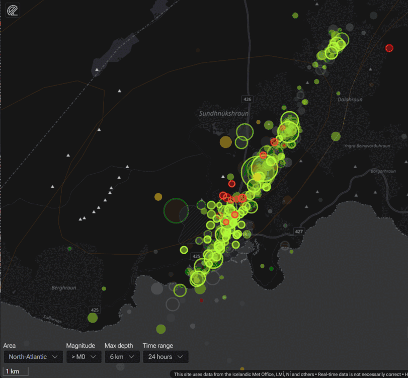
Around 600 earthquakes have been detected around the dike intrusion since midnight.
Models show a 15-km long magma intrusion, located just northwest of Grindavík. From geophysical models of the dike intrusion, it is estimated that the intrusion is propagating upwards slowly, with magma thought to be 800 m, or higher, beneath the surface. The likelihood of a volcanic eruption is high, and an eruption can be possible on a timescale of just days.
Thank-you for the reply Albert, and big compliment for Hector as author!
The Timafanaya model for fissure eruptions applies well for the Fagradalsfjall fissure eruption 2021-2023. Svínahraunsbruni reminds to what we experienced at Fagradalsfjall.
If the current Thorbörn eruption does a curtain of fire like Svartsengi and Reykjanes did 1210-1240, it’s the end of Grindavik, because it would mean that a long line inside the present Graben would open as a fissure eruption. Grindavik would share the fater of Goma 2002, would has to be rebuilt new in future.
Thanks for reposting, very nice work Héctor, perfectly understandable and interesting. Little by little I am starting to understand Reykjanes Peninsula a bit with the help of you, Carl, Albert, not to foget Páll Einarsson et alii.
I should go visit one of these days (in summer maybe).
One q: Is that Godinho who never says thank you to anyone a human being or AI, would be nice to know.
I’m sorry… i’s not because i don’t feel thankfull for all contributions. Just because i don’t feel much capable of saying much things and when i do i immediately get refuted so i stoped talking and just post info.
But thank you very much!
Good to know, you might just get very involved at times and forget. Thanks for answering.
Please know that your contributions are appreciated
Thank you very much! I always try to get reliable info to post… i really think my personal insights are not very interesting…
My personal insight is that I have always found your contributions very interesting. Please dont stop them. Everyone has different opinions and not everyone has a lot of tact in the way they reply. That has always been and always will be so.
I laughed at the thought of you being AI. If so you were the first AI to post on the internet as you have to my knowledge been around a lot longer than AI before it was capable of posting on internet for sure. Many thanks for your contributions over the years you have posted on here.
Thank you so much Alice, you are very funny! I’m ok don’t worry… i love your posts too! Thanks a lot!
well i find them interesting….. Please be comforted… this place would be dull without everyone giving input. Consider it an ongoing discussion over pizza and beer… with popcorn, of course.
I enjoy them, and especially the personal inputs. 🙂
Thank ypu!
..Attention focused on Hagafell…
Still a high probability of eruption near Grindavík. It is believed that the magma at its shallowest is around 400 m.
An imminent volcanic eruption is now even considered most likely at Hagafell, north of Grindavík.
https://twitter.com/Icevolcanx/status/1724747142349099282
Thanks for sharing.
Does anyone know which camera covers this area best?
This one is good,
There’s a static cam which also points in the right direction (east): https://www.youtube.com/watch?v=P1e_MWJ1nQc&ab_channel=mbl.is
Nice to know that one so thanks. IF it should erupt there or thereabouts there should be plenty of cams that could be focused in various directions around that area.
Thank you both (EverythingIsEasy, Alice) for sharing links to the relevant cameras.
If anyone else wonders:
Hagafjell is 1,5 kilometers east of Thorbörn (on the other side of Grindavikurvegur), and 1.5 kilometers north-east of Grindavik.
Indeed it would be very bad news for Grindavik should it erupt there but Grindavik is already so damaged in parts that I wonder how many would feel safe to move back there anyway. Clearly if the harbour was saved the fishermen would for sure.
I said it on the last page that maybe an eruption is actually the best outcome now, if still not an easy one to deal with.
If this dike doesnt erupt, then everything needs to be fixed and that will be expensive. Furthermore, this is now an active rift, and it is very likely to be intruded again, and each of those is more likely to erupt. So if nothing happens now things need to be fixed at great cost only to probably be destroyed again later anyway.
If an eruption does happen soon, regardless of what damage it does, then the message is clear and people will not stick around and risk it. So resources can go towards appropriate accomodation and maybe attempts to protect the power plant, instead of repeatedly refilling an opening rift and trying to keep the ocean away.
People don’t give up their homes that easily. Also, the fault that caused the cracking is now known, so can be avoided. That would seem to affect the sports centre and the golf course.
I have seen beautiful houses within meters of the San Andreas fault. People can live with uncertainty. Whether they should is another question..but where else on Reykjanes would you house one of the biggest towns? There is a reason it is there and has grown so much over time
Thats why an eruption now might end up being tbe best outcome overall. There isnt really a good option, but if there is anything that will stop people trying to risk living there while the rift is active it would be an eruption.
If anyone wants a map see https://peakery.com/litli-hrutur-iceland/map/
This town Grindavik has only 3.000 inhabitants it says.
Hafnarfjörður is ten times as large.
Maybe between Hafnarfjörður and Kalfatjörn?
Only the navy left in Grindavik?
Hagafell is what I’ve been thinking two days ago. But I bet my horses (that I still need to buy) on just north of Grindavik. I’m not leaving this cam out of sight: https://livefromiceland.is/webcams/fagradalsfjall
Just basing this on where the quakes are located when you get closer to the surface:
Even if a rift opens at Hagafell first I expect it’ll run down towards and possibly into town.
Btw I don’t like the panning of the other cam. It also seems of lower quality. If it were to erupt at Hagafell, I’d definitely notice it on the Faragdalsfjall cam right away due to the glow and maybe they’ll turn it around when that happens.
PS: weird patterns on the RBDCF seismograph right now. They get weirder by the minute. Home owner walking up the stairs?
The new RUV cam might be best as it pans around that area. Think the Grindavik one is fairly fixed and has the inner east slope of Thorbjorn in the way.
Which one is this? Do you have a link? 🙂
This one pans and zooms frequently : https://livefromiceland.is/webcams/fagradalsfjall
These also pan the area :
https://www.youtube.com/watch?v=PasUycyE96o
Hello,
Please check this webcam: https://spilari.nyr.ruv.is/sjonvarp/beint/ruv2
Geoscientists have said today that their attention is focused on Hagafell, which lies north of Grindavík and east of Þorbirn.
https://www.mbl.is/frettir/innlent/2023/11/15/kort_hagafell_og_sundhnukur_i_brennidepli/
..Optical fiber now used as a sensitive seismometer..
HS Orka’s optical fiber, which runs from Svartsengi west of Þorbjörn and from there to Arfadalsvíkur west of Grindavík, is now used as a continuous line of earthquake measurements with high sensitivity.
Distributed Acoustic Sensing (DAS) is a really cool use of fiber optic cables. A single fiber turns into an array of hundreds or even thousands of seismometers. It uses impurities in the fiber that cause backscatter to detect changes in length due to pressure waves. It allows for a much more detailed detection of microearthquakes.
https://en.wikipedia.org/wiki/Distributed_acoustic_sensing
Please see also https://www.youtube.com/watch?v=dOIANlUaxP8
Nice one Héctor, exactly the repost needed now. 🙂
There’s no sign that magma has stopped, even if earthquakes have decreased:
https://www.ruv.is/frettir/innlent/2023-11-15-engin-merki-eru-um-ad-kvikan-se-stopp-thratt-fyrir-ad-haegt-hafi-a-skjalftum-397151
Freysteinn Sigmundsson (geophysician) says the main threat are lava flows.
The current nature catastrophe is already the worst since Heimaey 50 years ago. He expects that the eruption begins like the introductory phases of at Fagradalsfjall’s eruptions. This might point towards the “Curtain of Fires” scenario with a fire fissure. But unlike Fagradalsfjall I think that the onset will be bigger and faster, but the time of the eruption will be shorter.
Maybe we should tune this down a bit from Twitter/Facebook-Style to VC-Style? It’s a fissure eruption. It’s not Pompeji. People will deal with it.
I will be back on VC later.. Im figthning a strong boneinfection in my broken foot, having constant medium fewer and is always tired, its still possible to do school and work but just barely and I been like this for over a month now. The truth is that it coud be up for the long term, lasting years but I hopes to be cured quite soon, but its a stalemate for now. Im eating antiobioctis and letting my trust in doctors, but the truth to be told, I can barely trust them when lots of the worlds healthcare ideas and practises are market driven and alot of medications like satins are litteraly a scam…
But I hopes to improve soon with specialized healthcare. This is a very good article, and Hector generaly perhaps makes the best VC articles out there, he is a fabulus addition to VC
Still my article will be posted in the near future, and another more analytical comming up later, but yes Im
ill and needs to focus on my treatment and other very busy stuff
Sorry to hear this! VC is not equipped to provide medical advice: we have to refer to trained medics. Your submitted post is being looked at.
Thanks! Im going to them althrough… not everything in the healthcare is perfectly trusty either…
like the classical very flawed “food guideines” and many medications that simply wont work at all.
But yes I have the best experts possible on my injury and hopes antibiotics thats usaly very effective can help with it. I will keep producing articles for VC and later it will be some in depths articles on some other Io stuff that I discovered/ or things that finds intresting, but I not started on them for now.
My current VC article needs some refinement, so I can can work with it when its in VC as a draft, wont be anything longer but perhaps some rer – writes, but overall its an overview of the subject and its overall complete, Ionian volcanoes is soon the only volcanoes that really thrills me, althrough Iceland and Hawaii are fun too with their sizes…
Really sorry to hear about your bone infection Jesper. That is truly rotten luck for you The biggest problem with antibiotics now is that their effects have weakened after so many years. I had a severe peritonsular abscess and it took two lots of penicillin and 2 weeks of severe pain before it was resolved. A bone infection sounds to be even more painful! My best wishes are with you for a speedy recovery.
i googled that… oooo sorry… sounds terrible. Hugs!
Thanks Mots. It wasnt fun when at its worst I was stuggling to swallow a sip of water. Especially when I tried to swallow and it came out of my nose instead. 🙂
Daughter was pleading with me to go to emergencies but I was so ill I could never have sat waiting for 5-6 hours in emergency waiting room. UK emergencies is now in a dreadful state but that is another story.
Jesper, check out ‘vitamin’D3. https://vitamindwiki.com/ Peter
It is also essential far up North to combat winter depressions.
If I don’t take them I get the winter blues really bad.
Fun fact, after they started to be widely recommended for general usage in Sweden, our suicide statistics dropped to half.
Fun factoid, our liquor stores was at the same time allowed to be open on Saturdays.
So, either saturday boose purchases or Vitamin D3 saved us from offing ourselves, you take your pick what you believe saved us.
Of, even if saving us was a good idea 🙂
Hahahah I so love this comment Carl. I still get winter depression despite Vit D3 but not as bad as it used to be before.
I am the weird inverse of what I would imagine characterizes >95% of people. I get depression in the summer, loathe the longer days and heat. Prefer the gloomy winter lack of sun, and the cold.
I’m from the northeast US so we don’t have quite the same low sun angle as Iceland and upper Scandinavia, but we do get quite cold here in the winter; I live for it. Nothing as refreshing as waking up in the morning to 15-25F (-5 to -10C approx). Wakes me up and makes me feel ready to tackle the day.
I’m also a nightowl, so that’s likely a part of it.
Ryan you are under the canadian freezer in winter and that spills out over the US plains very diffrent from the marine climate of Europe.. US gets extremely continetal so very cold in winter and souch coldwaves with No mountain ranges to block them can flow all way down to Maimi and give snow flurries there ..
Reykjavik and Gothenburg for comparsion sits in mild marine air and are both very warm for its latitude in winter often alot warmer than many american locales thats much further south than Europe
I hope you get well soon Jesper.
Well well the article is kind of like a draft and not perhaps fully processed, but once its in a VC draft I will keep inporving it before posting… its lenght is completed long ago.
Im very busy and will be back later, and will keep producing articles when i gets the time
Oh, Jesper! it sounds terrible…. please take Peter’s advice on Vit D. i remember the joy of finding You ‘live’ on the feed in Hawaii. Please take care. Best!motsfo
Jasper. Get well soon. Never mind posts that can come later. Just concentrate on getting better. XXXXX
Thanks.. well my next article is proably comming quite soon
Thanks thanks and partner does not like this, Im sick.. althrough luckly she is loyjal..
Yes one of my VC articles comming up probaly quite soon, and sometimes I doubt Im intelligent enough to write one hahah, Im not very good at it .. but its fun
It will be up as soon as is fitting Jesper.
Sorry to read this, hoping it improves soon. From experience and reading some reputable papers, I recommend high dose vitamin C preferably with Zinc, and preferably the dissolveable fizzy tablet sort. There seems to be a bit of decent evidence that the combo speeds tissue repair (no evidence that it ‘boosts your immune system’ as used to be touted around, but there is some that wound heal faster/ zinc deficiency is way more common than realised on a modern diet and that’s needed for this too).
Just the supermarket own brand will do, and the recommended dose. I’m fairly convinced it’s worked for me many times.
From the RUV news feed:
Magma is thought to flow into the passage from more than one place. It is thought to be at a depth of no more than five hundred metres where it lies shallowest.
“We could be looking at two processes that have been interacting all this time.” But we only saw what was happening in Svartsengi, and we are only looking at it [all] now,” says Benedikt Ófeigsson, head of land deformation measurement at the Icelandic Meteorological Office, in RÚV’s midday news.
Albert, Carl,
Pls give Jesper my email address. As a Em Prof of cell biology I know far more about D3 than the vast majority of medics.
Regards
Peter
One thing I do know about D3 is that most people in Scandinavian countries as well as UK are very low levels of it especially in the winter. I have to take it year round.
Without Vitamin D3 I would go into hibernation, before I started I slept for up to 12 hours during winter and was always tired, and when sunlight returned my batteries was so low that I got depressed.
Better you move and work south Carl…later when you are ready for that, I myself have no problems with short winter days, and specialy so when the snow is bright and crisp
If you send an email to the volcanocafe email address, it can be forwarded for you.
Thank you so much ! yet I have so kind of hard to trust in healthcare in general, its incredible how blinded most doctors are ( not necessary you ) to the health problems that western ideas and aged dogmas in terms of food and healthcare have created .. in the last 6 decades.
Doctors today are all about treating already existing problems of patients .. but they are not always talking about prevention of these terrible western diseases.. they are competely blind in that terms ( many of them )
Many things that we learnt through the decades, thats today standards like colesterols and satins thats all dead wrong, its incredible how economic intrests of the grain and sugar industry and Ancel Keys pesudoscience have been allowed to manipulate the entire worlds healthcare and food guidelines and that explains the poor health of the west world today. Here in the west world we needs to competely re – think the whole food and healthcare system beacuse its dead wrong and been since ww2 based on flawed pesudoscience ..
But overall in general doctors can and do provide good health, like how they are working on my injured foot
https://m.youtube.com/watch?v=lBb5TFxj1S0&pp=ygUVbG93IGNhcmIgZm9vZCBweXJhbWlk
The state of the world today, these pretty good documentary that dares to says the truth with Doctors really saying how it is.
I myself skipped ”western processed” food in 2020 and I do feel better, mind works better too.
Hopes the foot heals soon.. better to speak over the VC Bar
The reason they say that “fat is bad” fantastic saturated fats that we eaten for 2 million years now, is because the sugar and cereal industry typicaly says so, based on flawed 1900 s pesudoscience…it have no base in sicence at all, and as result the western dietary guidelines have become incredibely flawed.
I eat alot of moose meat, natural fats, and low carb greens, do I get bad blood values? the answer is NO…. the food gudielines are the biggest scam ever in the history of this planet.
I hopes a stone age pleistocene diet can help me heal my foot, I will be back later when I have healed the foot and gets less busy, in the meantime my article will be posted and I will work on other articles for Volcanocafe too
ah, only just seen this. Hope my comment about Vitamin C and Zinc was ok. It seemed to turn things around with infections so many times over the years for myself and family, but I’d love to know if there’s more proper evidence on it.
Thanks for D3 reminder!
Fagradalsfjall camera – something’s burning.
Or is it emergency vehicle lights? Sorry, jumping at shadows.
That boat which has been moored in the harbor seems to be moving.
I’m not sure if this has already been asked on? What is the isolated sometimes orange glowing building that lies about 800m NNE of the centre of Grindavik?
It can be seen centre left on the mbl,is Grindavik webcam.
It’s a greenhouse.
Lot of police/fire/EMS vehicles driving around Grindavik now. Generally leaving town, I wonder if this is something they do close to sundown?
Power went out in all of Grindavik and surrounding areas at 16:48:30, and now lots and lots of emergency vehicles all around..
looks like east side of Grindavik lost power, but power still on on the west hand side .. wonder what’s going on?
Western side got power back on after 20minutes or so, east, not so much.. at least street lights are out.
there is some fire in grindavik!!
The Langihryggur camera is frozen at the mo, but if you look on the multiview here, it’s camera no 1 (top left)
https://www.youtube.com/watch?v=804nPrAUAxg
and if you go back about 15 mins you can see ?steam or white smoke coming up at the saddle between the two peaks in the middle distance. This continued on til the camera froze, and doesn’t seem to be happening earlier on. Is it anything, or just steam from a geothermal place?
If you are talking about the two hills centre of the cam, than that’s the geothermal plant & blue lagoon. For some reason the steam seems more prominent around sundown so it looks like it has suddenly appeared.
Okay thanks. Good to know. I wish there was a map with the position of all the webcams marked and their fields of view. I get very confused …
Yes, it is very difficult getting bearings on what is an extended lava field with few obvious landmarks and what ones there are all look the same!
The cam you were watching is over the other side of Langihryggur valley that the lava from Fagradallsfjal ran into, will try and dig out the co-ordinates for it.
It is looking west over the area the dyke has formed under. The two hills the steam is appearing between, the left one is Porbjorn which has most of the other cameras on it, the right one is the smaller and nearer sylingafell, the geothermal plant is hidden behind it. The nearest and left most hill of the three in the mid distance is Hagafell and the area of most interest at the mo.
This link Jose posted earlier has a map/picture with the names on it which helps, the web cam we are talking about is actually located well to the left off the edge of that map.
Ooopps!
The link
https://www.mbl.is/frettir/innlent/2023/11/15/kort_hagafell_og_sundhnukur_i_brennidepli/
and the co-ordinates of that top left Langihryggur camera
63.87400520463494, -22.26224681965699
Most of the other cams are on the Porbjorn (weather?) station or very near it.
63.864049, -22.438308
I think the other cam that looks east across a steam field and geothermal plant is on the inland Reykjanes Lighthouse
63.81571183034424, -22.704160704016306
Many people will not have heard of this measuring technique: seismology with fiber optics ( DAS )
Fiber optic cables form the backbone of modern telecommunications; today the majority of data transmissions take place over them. But …
… these lines could also become useful tools for geoscientists in the future. The glass fibers can also be used as sensitive e-quake sensors, as a pilot test in 🇮🇸 shows. By analyzing the light signals in a data line there, the researchers were able to map movements …
… in the subsurface & the structure of the geological fault more precisely than with a network of seismometers.
https://twitter.com/DottirGongu/status/1724823979779563970
On the Fagradalsfajall cam the coastguard boat seems to be frequently using its spotlight. Anyone any idea what it would be scanning for?
It seems to be directed towards where the ‘lake’ is outside the town. A small boat went out from the main coastguard vessel for a short time – but they still have the spotlight on. I wish we knew what was happening – it’s like watching a thriller without the sound on.
Haha Talla. A brilliant analogy. I had to stop watching and watch a youtube video of sunny Portugal! 🙂 🙂 🙂
Is there some sort of power cut on the east side of Grindavik? Most of the lights have gone out on that side of town but not the other.
East part is without power. They are hoping they can fix it remotely.
Do they use underground power? Some areas where I live have both line power and underground power. I am curious if perhaps an underground feed got stretched and broke?
Within the town limits it’s most probably underground.
To be honest, I’ve been wondering why all the lights were left on in a town which has been evacuated.
So they can find it again
This made me giggle way to much.
Giggling is fine. Spurting red wine out of your nose, not so much.
Albert has caused me to spurt beer through my nose once.
He is very funny in real life. 🙂
There is no reason to turn off the electricity. Unless you want to invite all the burglars to the scene.
It’s the street lights, which are probably on a timer somewhere. Cutting the electricity would turn off freezers leading to rotten food and maybe flooding. They are hoping for the best (returning citizens to town soon) while preparing for the worst (eruption). I imagine the emergency services prefer to work in the light especially in an area where the road might have a new giant crack in it since they last drove down it.
Accidentally the east side of Grindavik is currently in higher risk for lava flows than the west side. If the eruption happens between Hagafell and Sundhnukur (100m above sea level) the lava would flow towards the eastern half of Grindavik and the settlements to the east of the village. The peninsula Hopsness shows a potential aim for lava flows. It has likely been built by pre-historic lava flows.
Now apparent that the Eastern half of Grindavik is without power? Scrolled the you tube feed back and it had power at sunrise this morning.
Lights on the #43 highway below Porbjorn a little earlier, i’m aware there are power lines in that area so wondering if they are trying to fix them?
https://twitter.com/volcaholic1/status/1724851210077839781
#Iceland A power outage hit Grindavík at 4:49 PM east of Víkurbraut. HS Veitna’s employees can’t access the town to diagnose the issue, and it’s uncertain if it will be resolved today. Half of the town is without power.
Thanks Luis.
Thanks!
I cannot see the logic in going to repair stuff inside a town that will soon be extinct, regardless of whether this eruption occurs in the coming week or so or not. How would they justify it if it erupted while 50-odd police and emergency responders were stuck inside?
Why would you think this town is going to be “extinct”? If it doesn’t go under lava, then when things quiet down, people are simply going to return. That’s what they did in Heimaey.
How can they return? There’s magma a few hundred meters under the surface, that could easily be activated by any future intrusion. The town was built on the end of the fissure that has erupted several times over over thousands of years – it was simply built in the wrong place! Even if it doesn’t erupt during this Reykjanes cycle, the infrastructure would need completely replacing and there’s no guarantee that there wouldn’t be future violent earthquake swarms to destroy everything again.
I’m pretty sure that things are going to go back to normal, it may take a year or two but they will. Unless of course it gets buried in lava, then we have a different scenario.
It would be best for everyone if it got it over and done with. To not erupt now could have dire consequences later in a month or two, or even a year or two if the population was present and had returned.
Fagradalsfjall erupted 3 times so far spread out, and from Hector’s article it seems clear that that is the modus operandi
It’s hard for a whole town’s population to ‘just write off’ their little town.
Besides, as has been alluded to here before, there’s still the harbour, which if intact and serviceable, can (and would be) used – at the minimum.
When there’s still a glimmer of hope for a good portion of the town to survive, it will.
And even if the entire town is “boofed” the Icelanders are way to stubborn to not rebuild the town, complete with a new harbour if needs be.
And during the eruption they would fight the lava every single step of the way.
I promise you will see a sort of fight not seen in decades.
And, the fun part is that the stubborn buggers have a 2-0 score fighting volcanoes.
A little bird told me they have saved at least one harbour from the lava before and that boat Thor is reputed to be carrying pumps capable of fighting for the harbour. Never forget the videos on the news of them soaking the lava with sea water. An absolutely amazing feat! The Icelanders never give up from what I have seen,
Exactly, they are stubborn and inventive buggers… 🙂
They also bested Fagra II and built that channel that diverted the lava flow.
My questions exactly. Looks like a mess trying its best to become a disaster. Of course I’ll wait to hear their reasoning on the amount of risk they’re taking on here. It should be something pretty darn important.
I think it’s the power plant since I’ve seen at least 20 emergency vehicles head that way. Power plants are pretty handy things to have running.
Currently the expected location for an eruption has moved to the area between Hagafell and Sundhnukur. This is on the east side of the road between Grindavik and Blue Lagoon. https://www.mbl.is/frettir/innlent/2023/11/15/kort_hagafell_og_sundhnukur_i_brennidepli/
I would be on a line between Geldinagadalir and Thorbjörn on the hills east of Thorbjörn and the road towards Blue Lagoon.
You sure need to see a specialist, Jesper, but as your father is a MD will know. With osteomyelytis it is important to know that antibiotics taken orally do not enter the bone in sufficient quantities, so it is often necessary to open up surgically and put a chain inside which contains the antibiotics.
Be careful and take care! Swift recovery!
Already does.. they are working on it
Will be more VC articles later from me too
They have to stop letting people go in now. Should be zero access for a week.
The shallow high plateau between Hagafell, Sundhnukar and Sylingarfell reminds to the a bit higher tuya of Fagradalsfjall. Maybe this was the site for prehistoric eruptions. Somewhere there around could be Thorbjörn’s Geldingadalir spot where it all is going to begin.
My money is on somewhere close to the greenhouse north of Grindavik.
Indeed I’d expect this Greenhouse has a great risk to be buried, but the location of the fissure itself is a bit more to the northeast. There is a shallow valley east of Hagafell which might play the role of Geldingagalir as the easiest way for magma/lava to the surface.
That’s a good shout actually, gravity plays a role also. Is it fertile ground there, is it a wetland? I think that would aid the ascent if the uppermost crust is slightly weaker. The magma is apparently only 500m deep near Sundhnukar and Hagafell so it’s a prime spot.
My money was IN the green house, especially at night when it was lit up like a Christmas Tree, that way it would take us some time to realise the eruption had started.
The US Navy transmitter masts lights are also not flashing tonight.
https://www.navifor.usff.navy.mil/Organization/Operational-Support/NCTAMS-LANT/Organization/NAVCOMTELSTA-Hampton-Roads/NCTS-HR-Detachment-Grindavik-Iceland/
Okay. That’s interesting.
This is a bit surprising, that facility should have backup generators turned on automatically by battery power.
And everything in duplicate.
It being dark sort of points to something being truly honkered in there.
Lurking would know more about how “armoured” a facility like this is.
Naval stuffs is sort of out of my remit.
Yes you would think there would be backup generators but one of the RUV cams shows that even lights at buildings onsite that were on this morning are not on now – so it isn’t just the masts. Perhaps any onsite generation was damaged earlier in the sequence?
Mods on the Live from Iceland stream have said that they have lost mains power to some of their cameras as well.
I do know something on stuff like this! Though admittedly, my area of knowledge is solidly on the aviation side rather than the naval side.
The urgency on this radar being brought back online will really depend on what kind of secondary coverage of the area is available and if there is anything in the area that requires monitoring or awareness maintained of. I’d be very surprised if there isn’t some sort of secondary coverage or even adjustment of other stations to minimise any darkspots. Most likely a risk-assessment has been done comparing the need for it to be online vs the current instability and risk to any personnel and assets sent in for urgent repairs and maintenance.
I would HOPE that the risk assessment came out to value the personnel over the station but honestly with the US forces you can never really tell what they value more, people or their expensive stuff.
That is interesting .As in any situation we see on the media there is usually a lot more happening in the background and under wraps that Joe public are not aware of. Decisions made by the Icelandic Defence agencies will be thoughtfully taken with all the expertise that they have with dealing with eruptions v populations. I dread to think what would happen if this scenario was in the UK at present. I am sure media Influencers would be holding forth and their followers bleating like sheep. (Please note I am quite aware that volcanic activity in the UK has only a miniscule/zero chance of hitting the headlines. We do have earhquakes though!)
Daily Fail is good at hitting volcanic headlines…
“Icelandic Deathmageddon Eruption”
Hahahah Carl. Never look at Daily Express online. anything weather related online for them makes Daily Fail look straw in the mouth Bucolic.
Curious how Icelandic media never mentions the facility. Maybe its invisible to Icelanders!
Hagafell considered possible center of activity/eruption site.
Power goes out in Grindaviks east half.
*>* looks at map.
Yes, I think so. It is part of the graben and would be nearly the northern 10-20% of the sill’s length.
A lava flow from the area there would threaten every place from the Blue Lagoon Road to Husafell (next hill to the east of Grindavik). The port would be in great risk to be buried.
And here is the different expert opinion: translate at your own risk.
https://www.mbl.is/frettir/innlent/2023/11/15/thad_verdur_gos/
Is he referring to a different place altogether than the Eldvorp at the end of the peninsula? Cause otherwise he’s gone funny in the head (like sure rift could erupt in 10-20 days but it isn’t galloping over there. Maybe he is meaning up toward the geothermal plant, since talks about Sundhnúka fissure?
He still thinks Eldvörp is the most likely site for an eruption.
Eldvorp is just west of the Blue Lagoon, where the sill originated. I think it will erupt at some point in the coming decades, but maybe not now.
I am sort of leaning towards either very crappy translation of going funny.
If it says something like Eldvórp going off next, that I could easily buy into.
But not now.
No, Eldvörp certainly is out of the race.
There is an Eldvörp just to the west of Grindavik, south of the radio masts.
Can you elaborate on this?
It is simple enough. There is an area called Eldvörp where I described. Found it on a map, surprisingly enough. No idea if that is what the expert is referring to or not, but thought I’d look for alternatives to the better known one.
This opinion doesn’t match with what IMO says and where the present graben/dyke is. Eldvörp was the location for the Middle Age Fires. That’s too much in the west.
Volc, eccentric was referring to ANOTHER Eldvörp. Maybe there are many…
One Eldvorp is next to Grindavik
eccentirc_viewer, you are absolutely right!!
There we are, as sad as this is, the scientist is not yet mad.
Well, it’s a different Eldvörp. But it is on the NW side of Grindavik, where previously it looked very possible that the eruption might happen. Now IMO looks to the NE side of Grindavik, where Hagafell is.
Volc, this should at least be in the middel section of the graben. If this scientist things it will start there, he might have his reasons.
The 10-20 percent law would put the eruption side not in the center of the line of the dyke/graben, but on one end. While the southern end has failed, the northern end appears to win.
I don’t know how to embed images here so here is a link. On this map you can see Eldvörp, it’s a 10 km long crater row west of Þorbjörn and pretty close to the original sill formation.
https://imgur.com/a/ohCd3RC
earlier while we were discussing Icelandic terms, I mentioned that I went nuts trying to track down Eldvorp. Way too many Eldvorps in Iceland it appears.
What if we get two fissures opening up, one near Hagefell and the other at Eldvorp???
I’m 100% sure from the context of this interview and previous ones with the same expert that he really means the Eldvörp area that is around 3 kilometers west from Þorbjörn and Svartsengi. His thesis is that the sill in that area is rapidly refilling and that eruption is still more likely in that general area than on the dyke near Grindavík.
Dear Bjarki. There is another Eldvörp. There may be hundrets. Perhaps we find out that it just means “hill where trolls eat” or simply “a place”. Maybe that’s the way they play with our nerves … (No, this goes too far.)
Has no one actually looked at that map? There is only one eldvorp; the word to the west of it is Eldborg.
I was once confused with the Eldvörp near the Airport. It is the Eldvörp GoogleMaps finds. There an eruption would destruct a lot of Hotels …
Or even a rift stretching from from Eldvorp to Eldvorp.
If you put Eldvörp into the search box at:
https://kortasja.lmi.is/mapview/?application=kortasja
you just get the two results, which was a shock for Icelandic place names. Its description is ‘Hraun’ which we all know is a lava field.
Clive: I blew all the coffee onto the keyboard. And it’s your fault!
A) Iceland is the undisputed champion of generic place names. B) Online maps are bad at conveying the relative “fame” of place names.
No local would ever think that name Eldvörp was referring to á tiny hill by Grindavík except if that was made explicitly clear. The crater row west of Svartsengi is THE Eldvörp.
Ding!
That explains it, he is talking about that Eldvórp!
I thought it was insane that he would talk out of his arse, but that Eldvórp is highly likely to go “boof” and is smakc bang on the dyke.
And it would give a reason for the lights being out at the Naval Station.
Nicely put.
And why the coastguard boat has had its spotlight trained in that direction all evening?
Weirdly it is marked on the map as Eldvörp, but if you search for Eldvórp, it pauses for a while then brings up Eldvörp again, but with the area highlighted.
(https://kortasja.lmi.is/mapview/?application=kortasja)
One would assume that Talla.
The IMO Office is carefully watching Hagafell, I saw the quake around 18:25 pm but they have upgraded the magnitude to 2.09 just now and even ran the beach ball on it.
Time: 18:25:11 2023-11-15
STÆRÐ 2.09 mlw
DÝPI 3.762 km
SVÆÐI: Suðurland – Reykjanesskagi – Svartsengi
266 STRIKE
64 DIP
-50 SLIP/RAKE
Seismic moment: 1.27e+12
NÁLÆGT Eldstöð: 6.6 km. VSV af Fagradalsfjalli
Byggð: 3.4 km. NNA af Grindavík (3535 íbúar)
Skjálftamælir: Grindavik (3.2 km)
GPS mælir: Svartsengi (2.1 km)
Auðkenni: 1276814
Do you have handy links that explain some of the data? I got the basics of the beachball but what’s STRIKE and DIP for example?
IRIS discusses this in their video https://www.youtube.com/watch?v=MomVOkyDdLo which is fairly easy to understand. Wolfram provides an interactive graphic so you can play around with the dip/strike/rake settings. See https://demonstrations.wolfram.com/EarthquakeFocalMechanism/
Berkeley has a nice explanation here too – https://seismo.berkeley.edu/~burgmann/EPS116/labs/Lab_01_Strike_dip/Lab_01_2016.pdf but basically strike is the angle of the fault in regard to the compass with 0 deg N and 180 deg S, dip is how vertical the fault is, a 90 deg dip is straight down, and rake has to do with with direction the fault actually moved along the strike/dip plane.
Thanks a ton! 🙂
It seems to me that the graben to the west of this quake has dropped down a bit further here if I am reading the rake correctly.
Development of magma dike under Grindavík
The magma dike that under Grindavík is about 15 km long. Eruption is most likely to occur where it is widest, at Sundhnúk or Hagafell. There are indications that the magma is at a depth of 500 m or less
https://twitter.com/Icevolcanx/status/1724862759450427556
Yes, this would confirm Carl’s 10-20 percent law. But on the northern 10-20 percent end of the dyke. Previously I and maybe others looked too much on the southern end in the ocean. The SW end failed, and the NE end is going to do the eruption.
There is a SW-NE line of prehistoric cones from Hagafell to Stora Skogfell. This line reminds to Fagradalsfjall’s line of eruptions 2021 to 2023. It could be the witness of a Fires Series some millenias before the Middle Age. Maybe the Svartsengi system switches from Fires to Fires between different sub-systems. Last time Eldvörp, this time Thorbjörn/Hagafell.
If the Thorbjörn Fires follow the model of Fagradalsfjall, the first initial eruption would be close to Grindavik. Later second, third, … eruptions would wander towards the NE and flood the whole area between the Blue Lagoon and Fagradalsfjall’s plateau.
This would help make sense of the one expert claiming the Eldvorp being the eruption area, not the Hagafell area. Your ideas are thought provoking.
((( Randall, there is a second Eldvörp right on the hot spot, close to Grindavik. See the two maps above. )))
Randall, please see the other Eldvórp.
It is smack bang at the 10 percent of the Southern end of the dyke.
I am pretty certain that the professor might be correct.
For everyone jumping at shadows and bits of steam… there will be NO doubt when an eruption starts. We’ve seen these eruptions start; there will instantly be a red glow across the entire sky, they’ll see it easily from Reykjavik!
The only thing that might prevent that is, if the eruption starts during daylight AND the area is completely covered by thick cloud – then, again as we know from previous eruptions, nobody will be seeing anything. But we’ll still know it happens; tremor way up, earthquakes stop almost completely.
Well, since you almost mention ist. Here is the first image of Fagra 1. I know the guy who made this screenhot, he’s still proud (and thinks that the cone should be named after him).
19.3.2021 22:07
That’s it settled then. We’ll wake up in the morning and not know there’s been an eruption last night until the sun peeks through the cloud for a couple of minutes at 11:20am
That wasn’t you, was it 🙂
I take naff pictures. So technically it could have been
A good friend. It is not my opinion, but HE says, it is not fair to make up silly long nordic sounding names for the place, when his name is so euphonious and easy to spell. Again, that’s not my opinion.
Is he called Dave?
It slips off the tongue better than Eyjaffalalalajokull
I can’t disclose, Andy, he’s a very humble guy. If he thinks that he deserves this volcano to be named after himself, he does it rightly so, because this magnificent image … (and so on)
Would that be Ed?
Ed was his horse, which by the way also saw the orange glow at the horizon, but oviously couldn’t make the screenshot (with only hooves and a horse keyboard not available).
Just looked back in the archive and you posted the first pic at 21.09, even better! Congrats!
https://www.volcanocafe.org/the-happy-dyke-of-fagradalsfjall/comment-page-3/#comments
Thx! (I’ll bookmark this immediately.)
I soooo remember watching that change from a glow to a full scale eruption. Whoever it was.. I salute them. Someone gave the heads up on that and it was way before IMO knew about it.
And this was my effort 🙂
https://twitter.com/eruptionchaser/status/1373028066260258820
Since I was the first one to accurately predict it I want to name it Carlahraun, he can get the cone 🙂
Blue lights again. I’m convinced that they are shooting wild police chase movies in the town, like yesterday.
Power is off in eastern Grindavik.
Is there a webcam fixed on Grindavik, please? The one I had has switched to scanning up to Blue Lagoon and back.
This one, Clive
https://livefromiceland.is/webcams/fagradalsfjall
Thanks! I also found this https://www.youtube.com/watch?v=hvcP4kVVOnk .
There was a line of police cars heading south into Grindavik just now.
Thank you for that link. The fagradalsfjall one has been frustrating me tremendously with a massive name spread across the view of Grindavik. wont use it now I have this so much better cam!
Alice: And “Fagradalsfjall” is of course completely wrong. This is part of a subtle strategy to make us all crazy, by on the one hand being the perfect organizers of this crisis (feeding the unstoppable narrative of the Icelanders and their overperformance) and on the other hand make uncountably many small irritating mistakes and misleading moves, like turning of the lights of exactly 50% of the town, spotlights into the water, 25 police cars entering the city, driving around and leaving within 15 seconds. We have to be strong and not let us being distracted by this. (Or maybe I should retire for today, wasn’t a pleasant day…)
Well Quinauberon they certainly made me crazy! I am a grumpy old woman and can no longer deal with such irritations! On which not I shall take myself off to be as I am convinced now there will be no eruption for at least 2 days. Cue an eruption in all its blazing glory and destruction…. while I gently dream of a beautiful garden that never has to deal with the ravages of autumn storms or winter frosts.
A lot of police activity now. Tom Cruise must be filming!
Maybe this time Tom goes too far (jump over the fissure?)
There is an article on mbl.is that says that there are still deposit boxes left in the bank. Bank staff were supposed to get them yesterday but weren’t allowed, so maybe it was done this evening.
Or was it fake police who had ‘acquired’ a nice set of keys?
What am I seen at cam #2?
https://www.youtube.com/watch?v=804nPrAUAxg
Is it a lava fountain? Has it started yet?
These are water droplets. The camera man is crying.
What is that bright light roughly in the middle of the Fagradalsfjll camera – varies in brightness, looks like its on the harbour?
Coastguard ship.
That is the Coast Guard Ship Thor.
It is using its flood-lights.
Thor has got bored and gone away (like all Norse Gods he’s got a small attention span). But Freyja has arrived to turned her light on what’s going on. 🙂
Ah, and like all women she like to shine 🙂
Well the sailors on Thor really deserved some down time. Thanks for the update.
OK I have talked myself into beliving that its real now……..
They might be running on Diesel now. We know they had rotating equipment on standby.
interstingly watcching more vehicles exiting the town via the smaller western road rather thaan the bigger main road(more centre of the screen)
All distraction, Diana. Like with Bardabunga, when we had Champaign corks popping and then it was just their silly scientists Jeep (Was it midnight?). I’m planning to ignore all this. They can even put on a huge rotating Ferris wheel, I don’t care.
Carl and Quinauberon – thank you both for steering me to the right Eldvorp. I could NOT hit the reply button on your posts because the WordPress website does NOT have a reply under your posts to me. So pardon me for posting into the main to say thanks.
Question for Carl: Are you thinking Elvorp is to be preferred over Hagafell? I was wondering if the SO2 meters were leading the IMO to consider Hagafell?? What are your thoughts now?
I am favouring the southern end over the north end due to it seeming to have more strain in the crust in this section, and it was in this direction more of the magma moved.
I am curious about the reasoning behind IMO’s assesment, especially since the professor was not “funny” (he is actually very good at this, hence my surprise).
I would say anywhere from between Thorbjörn and Eldvórp (the correct one) is the most likely stretch since it falls in the 10-20 percent “rule”.
Has the sill area stopped deflating? With the pressurised magma in the sill being pumped into the newly formed rift it becomes a matter of volumes. If the sill has been drained but the feeder is still active @ 5m3/s then it will take a while to fill up a 15000m x 1m long rift to overflowing, ie it would increase by 2.5m per day depending on how gassed up the magma is it might just ooze out slowly if it does reach the surface.
Someone found the cause of the power failure.. 😉
https://youtube.com/clip/UgkxZFoetBN8mk_ybwI_t0e2_iKVCUzdkiMb?si=RRYPFWcEteCAkT0T
I haven’t spent much time looking at the live camera footage (I have precious little free time these days) but I did spot something yesterday; a moving light source near the power plant. It seemed to be headlights.
I’m no expert at lava behavior, but I’m pretty sure lava doesn’t usually use headlights, even at night. I do, however, suspect that there might be ongoing berm work at the power plant, or, a staff member at least paid the plant a visit.
As for Grindivik being repaired or rebuilt, I can only note that there are communities in Kilauea’s SERZ, such as Lelani Estates, Puna, etc, which have had lava issues, and were not abandoned. Likewise, many areas are under threat from Mauna Loa. There are also many other sorts of risks, such as flooding – Much of New Orleans is below sea level, and the area is a major hurricane zone. And, in my case, I live in a forest in an area prone to wildfires, and I grew up in California in an area prone to both wildfires and earthquakes, and went through several of both. Life, after all, has risks.
Yes CJ I read somewhere that work had started on defences for the geothermal plant, just last night.
Thanks! That fits, unless I’m wrong and it’s lava using headlights. 🙂
The power plant is being operated from a remote location. Headlights are likely from the cavalcade of dumptrucks and earth movers racing against time to erect a barrier to protect the facility. It’s 40 or so machines, around the clock.
But yes, someone could definitely have gone to the PP itself for recon or to attend to some stuff.
What I saw, at first, was a sudden increase in glow from what looked like mist or steam, then the moving spot of bright light emerged. A vehicle emerging around, or over, a berm (or any rise in the land) would sure fit. I’m not at all sure exactly how close to the powerplant it was, just that is was next to the misty bit I’ve seen described as the powerplant.
I hope the defenses work if it comes to that… for the powerplant and the Blue Lagoon both.
Leilani Estates wasnt abandoned because finding somewhere to live in Hawaii is outrageously expensive, Puna is the cheapest place to buy in Hawaii, despite the hazard. Grindavik is not really comparable, people can more easily move althpugh that doesnt concern personal matters of attachment.
I do wonder if having the lowest prices in Hawaii is due to, rather than in spite of, the volcanic hazard. 🙂
That is interesting .As in any situation we see on the media there is usually a lot more happening in the background and under wraps that Joe public are not aware of. Decisions made by the Icelandic Defence agencies will be thoughtfully taken with all the expertise that they have with dealing with eruptions v populations. I dread to think what would happen if this scenario was in the UK at present. I am sure media Influencers would be holding forth and their followers bleating like sheep. (Please note I am quite aware that volcanic activity in the UK has only a miniscule/zero chance of hitting the headlines. We do have earhquakes though!)
We had a sharp jolt a few years ago that cracked the livingroom ceiliing. On phoning our insurance co. I was told scornfully” We don’t have earthquakes in the UK,” I promptly sent them the page from the BGS showing the magnitude etc. They sent round an assessor. I blinded him with science and printouts & they paid up!!!!
Lol Diana. I am sure there are plenty of **influencers** (double parenthesis because they couldn’t influence a maggot to eat cheese) out there that have so few marbles that they would try to make out the UK could have an eruption in Bath because they have hot thermal springs there. The empty headed leading the blind and both fall into the graben!
Now in the words of someone greater than me, “to bed, perchance to sleep.”
Or maybe “sleep that knits up the ravelled sleeve of care.” Night all.
Well it should have been parenthesis but someone somewhere decided I should put stars.**********************************
LOL I too thought of Bath………May I take this opportunity to apologise for wierd typos on my ccomments but undergoing all kinds of therapies at The Christie Hospital in Manchester…some of which are radio active. My husband and i are sad because I don’t glow in the dark thus saving heat and light power.However some do make me more shaky than usual, Also after Sunday I will have my first cataract removaal and new lens so I should be able to see the keyboard better.
+
That is a good hospital. I hope it all goes radiantly well for you!
Sorry to hear about your problems Diana and hoping and praying you get some respite soon from the effects of the therapies. Thankfully my cataracts are developing slowly but messages to firend on my phone tend to be something concocted by the chuckle brothers. Tiny keyboards never work well with a combination of failing sight and fat fingers but hey, if they are friends they understand as we all do also. sending you love and best wishes.
This looks cool. Thanks Luis.
Is there anyone out there who can explain how to interpret this unto to a non geologist?
Thanks in advance
Thanks! Yes it’s very cool!
It’s similar to the links (and explanation of frequencies) I shared the other day:
https://www.volcanocafe.org/the-grindavik-update/comment-page-4/#comment-138747
Thanks. Is the DAS a bit like the drum plots? Everything vibrating the ground is recorded so you have to take account of traffic waves and wind?
What would we look for to see if magma is moving? More consistent, sustained red along cable?
Any guidance welcomed!
Beardy Gaz: the quakes hitting are easily recognizable, but what about the band about 1/4 the way down from the top? Is that low level freq intermittants, which I would guess about Torbjorn level? The red bands at the bottom make sense with the sea near by, and the top would show the power plant, of course. Just curious at to what might be happening in the region about 1/4 the way from the top??
By comparing the total length of the cable with features in the map, that might be where the cable crosses the road to the blue lagoon. Maybe it’s placed in some other type of conduit, or the contruction of the road itself has an impact on how well ground waves are tranferred into the fiber.
Or it’s just a problematic segment of the fiber where the DAS technique is unable to resolve the signal.
Damn, this is so impressive! Amazing technology and physics element.
See https://www.optica-opn.org/home/articles/volume_32/june_2021/features/das_a_seismic_shift_in_sensing/
OMG thanks for this! I looooove realtime data visualization. I could look at this all day. 🙂
For our new readers/commenters: you may wonder what you were signing up to when (if) creating a user account. Our internal use of your precious data is explained in this old post on our GDPR interpretation. Nothing much has changed since.
https://www.volcanocafe.org/volcanocafe-and-the-gdpr/
Phew! I was concerned when I started getting a flood of emails and web ads (that looked like they were AI generated) purporting to be of ‘Vulcanologists’ touting the health benefits of Vulcanized Vitamin D3 suppositories.
Nice to know that VC couldn’t *possibly* have been a source…
🙂
In all seriousness, though, I love this community, though the pressing needs of life and work don’t let me spend as much time here as I would like. Thank you for all you do (and thanks for doing with grace, panache, humor and, above all, patience!)
Still think that to the SE / E of Þorbjörn is most likely. I’ve seen nothing to change my mind. If I was pushed for an exact location, just to the E side of route 43, between Þorbjörn and Hagafell.
I might be talking out of my behind of course. Following patterns / gut feeling doesn’t usually work too well for me!
I agree. Eruption will likely be to the eastsoutheast of Thorbjorn, probably just south of Hagafell, and north of Grindavik.
The authorities did think the same but they seem to have adjusted the most likely location further north, to Hagafell or immediately NE.
Minor differences but could make all difference regarding lava paths.
Are there any webcam pointing east of Mt Thorbjörn?
Would like to know this too.
The standard webcam does not capture the likely eruption location, whether it is NE or SW of Hagafell.
There is a static camera pointing east (directly at Hagafjell) located at Thorbjørn, as well as cameras at Sylingafell pointing southwards.
Sylingafell is located approx. 2 kilometers north of Hagafjell (and Thorbjørn) and the cameras points (and pans) southwards.
Here is a link to a panning version:
https://www.youtube.com/watch?v=Qvw5qh5K4wI
I can’t locate the link to a camera at Thorbjørn pointing East, but I’ll take a look in the morning (in daylight) and provide one then (if I find it again) 🙂
There is one pointing west TOWARDS Þorbjörn which was installed 1-2 days ago:
https://www.youtube.com/watch?v=HJWj-1RIIgM
This is the one to watch IMO. It covers the south including Grindavik and occassionally pans northwards towards Stóra Skógfell – all potential eruption locations in clear view! Unlike the camera on Þorbjörn itself whose view is somewhat obstructed in the lower part due to the cliff on the hill. I also haven’t noticed it shaking in the wind either.
I’d just like to share a few fun Google translations I enjoyed today from various Icelandic pages.
From MBL, Þorvaldur Þórðarson thinks the chances of an eruption are diminishing:
“I think the chances of an eruption decrease, at least on the reindeer that is closest to Grindavík.”
But his colleague, Ármann Höskuldsson, disagrees:
“It’s going to be a blast”.
And finally the more brave among us might be inclined to have a read of the enlightening Icelandic Met Office report entitled “Menstruation in October 2023.”
I recently read one about the authorities gathering in a parking lot “with all their sea urchins” and waiting for further instructions.
I had a blast with that one! 😀
Also quite frequently I read sentences like these:
“something is not going to happen BUT something else is not going to happen”
It makes me think that double-negation is maybe somewhat special in Icelandic and actually negates the second part of the sentence, meaning the other thing IS (but .. not) going to happen.
Professor Thorvaldur Thordarson is now stating that the likelihood of a volcanic eruption within or close to town #Grindavik is now considerably less than before; due to different rock layers interacting. But as #Icelanders known too well: The Forces of Nature can surprise us!
https://twitter.com/ORGrimsson/status/1724919726348898323
Are they still measuring SO2 there?
Different rock layers interacting? I guess it’s a “lost in translation” event. I must confess, when walking in rocky areas I’ve not noticed any rock layers actively interacting with each other. Most are usually entirely quiescent and wet from pouring rain (UK weather).
Strange.
Reddish, intermitent, non-regular flashes from Reykjanesviti (and sometimes from Langihryggur). They were more visible than 2 hours ago, when I fist spotted them.
https://livefromiceland.is/webcams/reykjanesviti
https://livefromiceland.is/webcams/langihryggur
But now there is a dense fog… nothing visible… We’ll see tomorow, folks!
fire ?: cam fagrad