Texas-Sized Transit: A Vision for Metro in Austin
Hi! Ace here.
I am an architect and urban designer who focuses on projects in cities and specializes in housing. I am also someone who does not know how to drive, so aside from walking my main way of getting around is transit.
The city of Austin and its transit agency, Capital Metro, are currently in preliminary design and discussions concerning a 2020 ballot measure to fund additional mass transit in the city. While there is an agreement on the need for additional transit options in the metro area, there is a significant amount of ambivalence towards deciding on the exact routes, the type of service, and the funding structure for the projects. As a former Austin resident for nearly ten years, I recall past failed ballot initiatives and how even if those small improvements to the system had been approved, they were not nearly enough to turn the tide on a city that is still extremely auto-centric.
I now practice architecture in both Austin and Seattle, however I base myself out of Seattle for a number of reasons, a major one being its robust transit system. Seattle has a good (recent) history of supporting mass transit and its expansion. The most well known recent example of that is the 2016 Sound Transit 3 (ST3) ballot initiative which approved roughly $54 billion in mass transit improvements across its service area. Austin’s last approved transportation ballot initiative was this past year, 2018, to the tune of $160 million mostly centered around road improvements.
There are a number of reasons for the disparity seen between the two proposals, one of those populations of the two metros. In 2018, the US Census Bureau estimated the Austin-Round Rock metro to be home to 2.2 million individuals. The Seattle-Tacoma-Bellevue metro was estimated at 3.9 million, nearly twice that size. That said, Austin has a history of doubling its population every 20 years and by estimates would reach over 4 million in the area by 2040.
Given the large increase in population that will occur and the Texas tradition of aiming to be the biggest and best at everything, I asked:
What could a subterranean light rail / metro system look like for Austin that was funded by an even bigger ballot initiative?
Something like this:
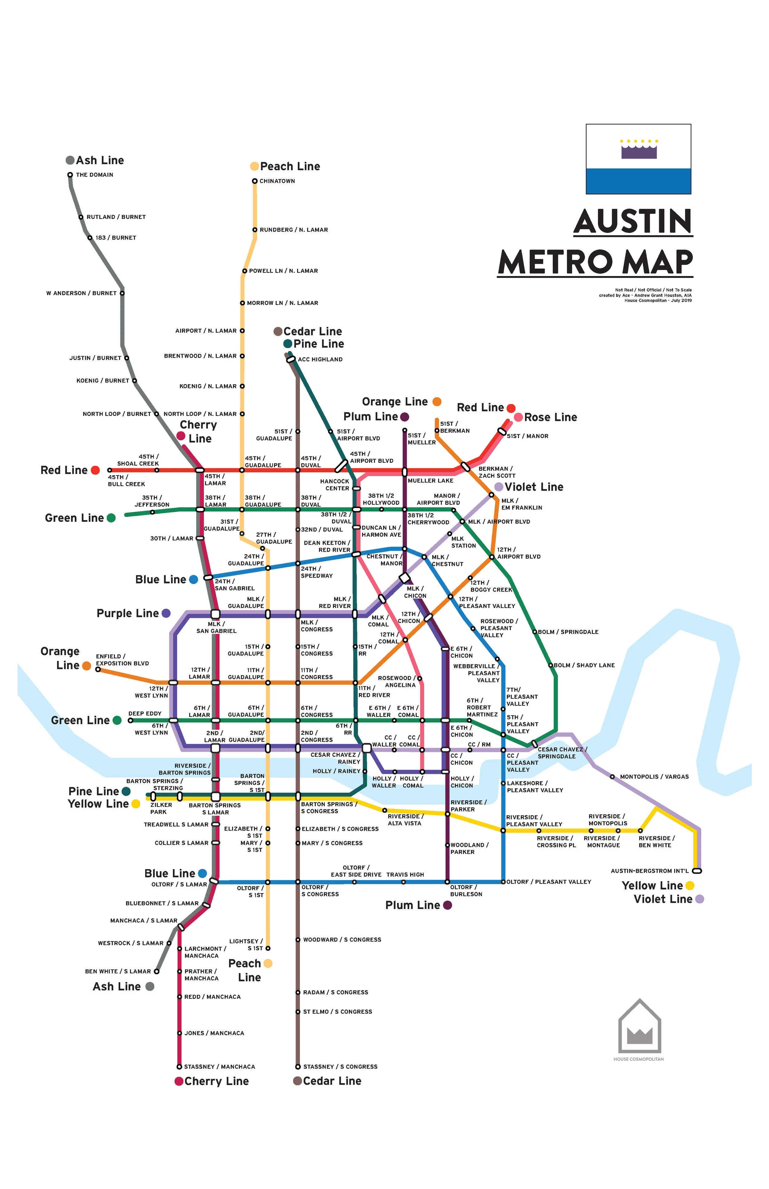
The cost? 100 billion dollars.
This project is definitely a moonshot, but one day in the near future this system could be as beloved to Austinites as the Moontowers.
Design Process
To explain a bit on how I decided on the parameters for this project, it was fairly straightforward. I chose subterranean because it was a compromise between dedicated travel lanes and a removal of current vehicle lanes, typically seen as a Texas no-no. Each mile of tunnel for lines would be estimated at costing 1 billion dollars, a nice round number higher than the current most expensive light rail under construction but close enough to be realistic upon completion. There would be 14 lines (because NYC has 27 and their population is over 8 million per Census estimates) and they would be broken down as such:
1 line to the airport from downtown
7 lines would be focused north-south for commuting
3 lines would be focused east-west for connections
3 lines would create loops to avoid the need to go downtown for every trip
The north-south lines are all named after Texas trees (Ash, Pecan, etc.) and the other lines are named after colors. No more than two lines were allowed per tunnel, to avoid the follies of cities’ past. In terms of the number of stops, I used my history of living in Austin to focus on neighborhood/institutional centers, apartment clusters, major cross streets, connections to existing transit, and then attempted to balance the number of stops across lines. There are a total of 147 stops on this map.
What I Learned
Through this exercise, I learned quite a lot. First off, for better or worse, the nice grids of Central and East Austin lend themselves to creating simple lines that create their own grid of transit. It makes sense to serve these areas because most lines heading into downtown must come through these areas This is also where most of the larger apartments and more dense parts of the city are.
Servicing the rest of the city is much harder. I attempted to follow the major corridors in Austin, the focal point of new density in the city per the Imagine Austin plan, however the great lengths I had to go to in order to get service to some parts ate up my budget. Case in point, as great as connecting the Domain and downtown with a faster option, the Ash Line goes for 6 miles before it intersects with another line. I decided in some cases the choice to extend rail didn’t make sense for how few people lived there. This is also why the Green Line and the Blue Line are not complete loops.
Even with this large of an investment, based on a half-mile walkshed around each line (a rough estimate to balance those that may drive to rail and the reality of Texas heat) and the average density of Austin, the estimated number of passengers served per mile would stand at 1977 people. To put that in perspective, the Central Link of Sound Transit serves 3734 passengers per mile, nearly double that amount. There is an argument that the Link goes through the densest parts of Seattle, however looking at an average density of the two cities the numbers check out. A 2017 article from Curbed showed that if Austin was as dense as Seattle it would cover 42% of its current size. Bluntly, if Austin wants to be successful at transit and see a better return on investment for any project it needs to get more dense.
Architecture and Mobility
Housing, and by extension all architecture, is severely impacted by transit and mobility. How someone moves through a city is key to how they experience it and how they live their life. Given the current climate crisis the entire world is facing and the need to shift away from our dependence on single-occupancy vehicles (read: cars), we have to think bigger than we have ever before. This is true for every metro area in the United States and for the country as a whole. A project like this would not be feasible without some federal dollars, and the total amount of grants given out last year by the Federal government for all projects in the US stood at $15 billion. I will save state and local funding of transit for another time.
House Cosmopolitan is an architecture and design house committed to designing places where people belong. My ability to create change is limited as a transit advocate, however as an architect I can work towards designing places that speak to the eclectic, eco-centric, and—most importantly—friendly nature of Austin and that allow people to live more closely together in communities and neighborhoods that speak to the best things about our beloved city. If you have a project in mind that you believe speaks to this mission, please reach out to us so we can make your dream a reality.
(A geographically accurate version of the map can be seen here.)