
Caño del Aguadero Trail (Sierra Mágina NR) – PR-A 350
Along the Caño del Aguadero trail - PR-A 350 there are many traces of a past and present marked by livestock farming. These traces, the cattle tracks and other related elements (resting places, drinking troughs…) really stand out. These routes form a colossal network of paths from the Middle Ages throughout the whole of Spain, and for centuries it was the only road network that had the capacity to link the whole territory.
It is a journey towards the mountains that culminates at over 1,500 metres of altitude and will end up taking us, via a route full of attractions, to see an ancient landscape with a considerable imprint made by livestock farming: the old royal cattle track, cattle sheds, refuges for shepherds and hunters, resting places, drinking troughs, etc
It is a demanding route through the Sierra Mágina Natural Park, but one full of glimpses of a past in which the seasonal movements of the cattle being put out to pasture formed part of the daily life on these mountains.
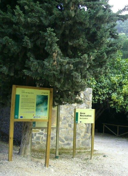
The Cuadros recreation area is the starting point, where we can leave the car. The path climbs upwards for several kilometres between the pine covered hillsides. In this first section, to the right of the path, we will have a view of deep mountain stream valleys that meet and collect the waters of this part of the massif. The valley of the Cuadros River, the Mosquito and Peru ravines, are interesting because of their cornicabra olive trees, which are typical of this area.
The first section of the trail ends in Valley Checkpoint, a building next to a checkpoint barrier which has an esplanade where you can rest. Depending on the season, we can find water here to cool down.
We have yet to reach the Era del Curilla threshing floor, in the mountain pass of the head of the Barranco del Atanor ravine at 1,100 metres of altitude; a natural pass that connects with the eastern side of the massif. The threshing floor that was erected there used the air currents between two slopes to winnow the wheat, making use of the constant flow of air.
Now we have the longest section still to do, a little over eight kilometres still until the top of the hill. During this stretch the path follows the hillside of the Sierra de la Cruz, negotiating ravines which, one after the other, allow us to gain altitude. The landscape changes to mountains covered in black pines, a tall tree, combined with cornicabra and even boxwood trees. Do not forget that we are on the north slope of Mágina, which is a little damper than the other parts of the mountains. To the left of the path we will find different mounds or hillocks, high up and isolated. To the right we can enjoy the impressive view from the head of the ravines that we saw at the beginning of the route.
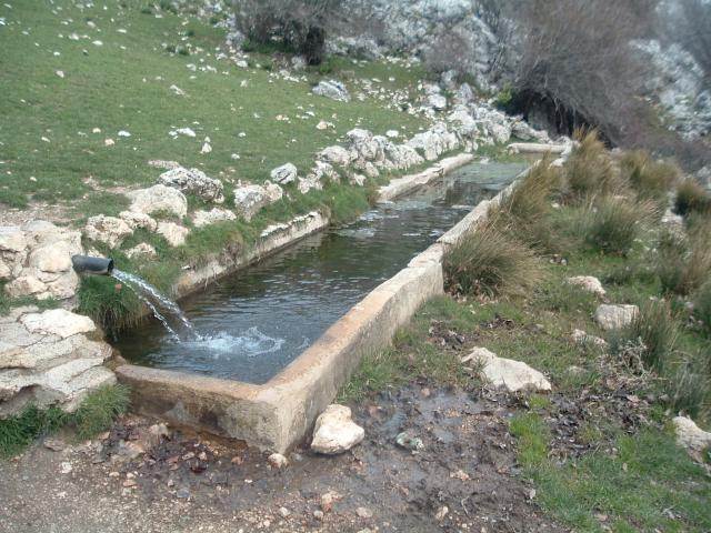
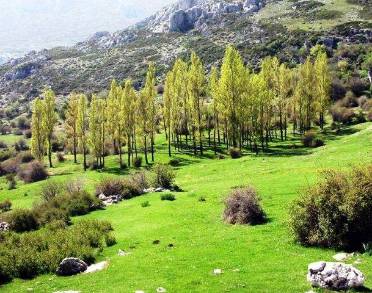
The path becomes flat, and we now just have to amble along to the Caño del Aguadero spring. The route is flanked by high pastures, traditionally home to flocks of sheep. When you pass the Hoya de La Laguna - to the left of the path - a small sinkhole or hollow in the rocky limestone floor, you will be very close to your destination. The appearance of black poplars will tell us that there is water, the gushing water of the Caño del Aguadero natural spring.
The cattle shed, the fountain and the drinking troughs are the end of the path. This spot is a resting place in the middle of the massif, and is part of a Cañada Real (a royal cattle track). The meadows, the constant presence of water, the view and the shade of the black poplars makes it an ideal place for spending some time relaxing in this part of the Andalusian mountains. Peña Grajera rock (2014 m) crowns the landscape, and the conditions high up in the mountains remind us of where we are now.
To get back, we will retrace our steps back down the path we came up, which will take around three and a half to four hours. It is possible to connect to other trails from different slopes. This option requires careful planning and experience in mountain orienteering, as well as many more hours to get back to the villages around the massif.
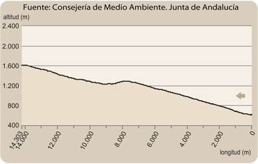
Type of Trail: Linear. Trail Status: Approved and Signposted 2012. Total Length: 14.3 Km (one way). Sections: 1 Accessibility: It can be done on foot. Download Topographic Guide
Itineraries

Services and infrastructure
Target audiences
Segments
Season


EXPLORE ANDALUSIA
EXPERIENCES


