File:Almohad Expansion-es.svg
Jump to navigation
Jump to search

Size of this PNG preview of this SVG file: 800 × 541 pixels. Other resolutions: 320 × 216 pixels | 640 × 433 pixels | 1,024 × 692 pixels | 1,280 × 865 pixels | 2,560 × 1,731 pixels | 1,713 × 1,158 pixels.
Original file (SVG file, nominally 1,713 × 1,158 pixels, file size: 2 MB)
Captions
Captions
Add a one-line explanation of what this file represents
Summary[edit]
| Description |
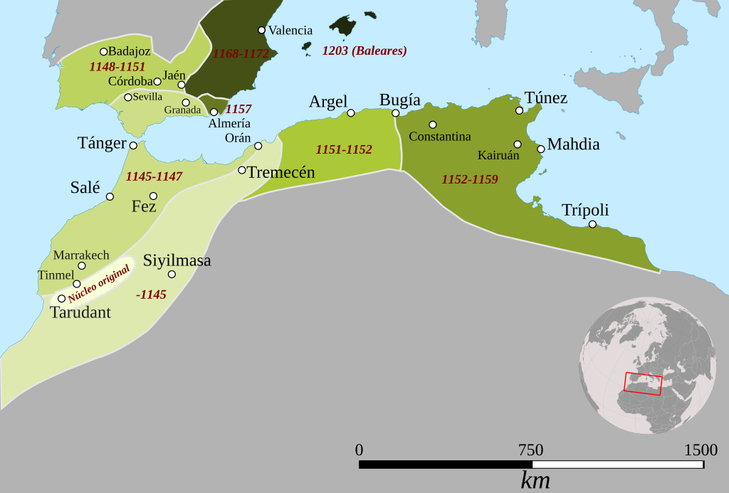
English: Phases of the Expansion of the Almohad empire. |
| Date | |
| Source |
Almohad Expansion.png Base map (coast, territory, rivers...) from Natural Earth Location of towns from Wikipedia Projection: Africa Lambert Conformal Conic (+proj=lcc +lat_1=20 +lat_2=-23 +lat_0=0 +lon_0=25 +x_0=0 +y_0=0 +datum=WGS84 +units=m +no_defs) |
| Author |
|
| SVG development |
Licensing[edit]
This file is licensed under the Creative Commons Attribution-Share Alike 3.0 Unported license.
- You are free:
- to share – to copy, distribute and transmit the work
- to remix – to adapt the work
- Under the following conditions:
- attribution – You must give appropriate credit, provide a link to the license, and indicate if changes were made. You may do so in any reasonable manner, but not in any way that suggests the licensor endorses you or your use.
- share alike – If you remix, transform, or build upon the material, you must distribute your contributions under the same or compatible license as the original.
File history
Click on a date/time to view the file as it appeared at that time.
| Date/Time | Thumbnail | Dimensions | User | Comment | |
|---|---|---|---|---|---|
| current | 08:10, 19 July 2021 | | 1,713 × 1,158 (2 MB) | Rowanwindwhistler (talk | contribs) | Inset corrected, frame hidden. |
| 08:07, 19 July 2021 |  | 1,713 × 1,158 (2 MB) | Rowanwindwhistler (talk | contribs) | New colours, legend information now in map. Location inset added from https://commons.wikimedia.org/wiki/File:Expansi%C3%B3nAlmor%C3%A1videSimplificado.svg | |
| 08:17, 20 January 2017 |  | 1,731 × 1,331 (991 KB) | Rowanwindwhistler (talk | contribs) | Fake text added | |
| 11:01, 30 July 2016 |  | 1,731 × 1,331 (758 KB) | Rowanwindwhistler (talk | contribs) | Larger, not truncated version | |
| 10:57, 30 July 2016 |  | 431 × 254 (828 KB) | Rowanwindwhistler (talk | contribs) | User created page with UploadWizard |
You cannot overwrite this file.
File usage on Commons
The following page uses this file:
File usage on other wikis
The following other wikis use this file:
- Usage on ast.wikipedia.org
- Usage on es.wikipedia.org
- Usage on es.wikibooks.org
- Usage on uk.wikipedia.org