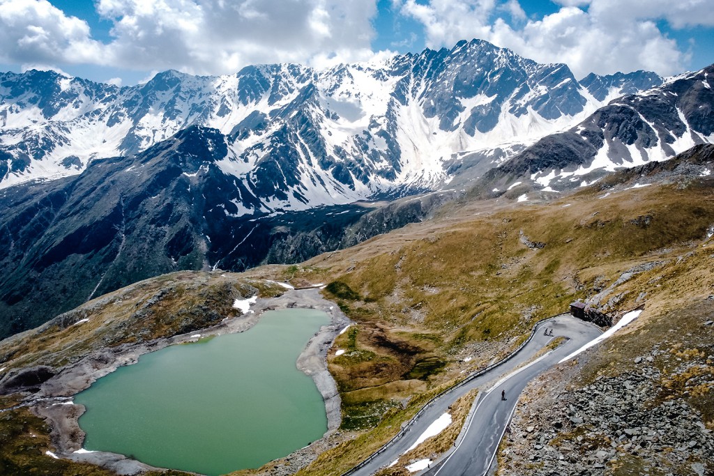
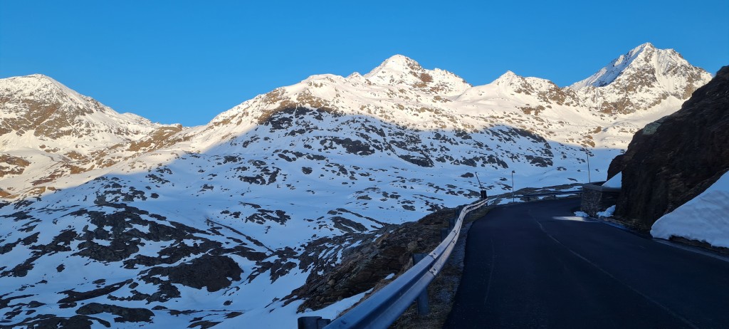
Passo di Gavia from Bormio

Passo di Gavia from Bormio is a climb in the region Lombardy. It is 24.8km long and bridges 1396 vertical meters with an average gradient of 5.6%, resulting in a difficulty score of 978. The top of the ascent is located at 2618 meters above sea level. Climbfinder users shared 28 reviews of this climb and uploaded 50 photos.
Road names: via santa Caterina, Via Plagheira & Strada provinciale di Gavia
5.0 by VortexmindThis is an automatic translation, the original language is: Italian.I decided to attempt this climb the day after the Re Stelvio MAPEI in July. As I woke up pretty early, I was already on my way outside Bormio and towards Santa Caterina Valfurva at 6:30 am. At this time the road was pretty much empty and enjoyable, only sounds being that of birds and of the river. O... read more
Photos (50)


If you want to upload your photos, you need to create an account. It only takes 1 minute and it's completely free.
- Add photos of your conquered climbs.
- Share your experience on all ascents you've climbed
- Submit your favorite climbs
Statistics
| Passo di Gavia from Bormio This climb |
Lombardy 657 climbs | Italian Alps 1773 climbs | Alps 4959 climbs | Italy 4875 climbs | Europe 42955 climbs |
|---|---|---|---|---|---|
|
978
|
rank
76
|
rank
252
|
rank
563
|
rank
282
|
rank
849
|
|
Average gradient
5.6%
|
rank
493
|
rank
1357
|
rank
3523
|
rank
3034
|
rank
17850
|
|
Length
24.8km
|
rank
15
|
rank
57
|
rank
132
|
rank
109
|
rank
434
|
|
Total ascent
1396m
|
rank
24
|
rank
93
|
rank
167
|
rank
104
|
rank
332
|
Classification
Road surface condition
Traffic
Climbing times
| 7 km/h | 03:32:37 |
| 11 km/h | 02:15:18 |
| 15 km/h | 01:39:13 |
| 19 km/h | 01:18:20 |
Popular


Reviews (28)

I decided to attempt this climb the day after the Re Stelvio MAPEI in July. As I woke up pretty early, I was already on my way outside Bormio and towards Santa Caterina Valfurva at 6:30 am. At this time the road was pretty much empty and enjoyable, only sounds being that of birds and of the river. Once you get to S.Caterina, the fun part starts with nice hairpin turns in the middle of the forest. The road keeps climbing at a steady and manageable pace. Further up the forest gives way to the "malghe" (or alpine pastures) and here also comes the steepest bit of the climb just after Ponte dell'Alpe.
All the effort on the steep bit was rewarded shortly after, as I was greeted by the whistling of the marmots that didn't expect a cyclist climbing there so early in the morning :-)
The last few KMs ease up a bit, and allow you to admire the fantastic landscape and mountains. I have really enjoyed the climb to Gavia pass and being there in the early morning during the golden hours, together with the little to no traffic encountered, made it a unique experience.
I decided to attempt this climb the day after the Re Stelvio MAPEI in July. As I woke up pretty early, I was already on my way outside Bormio and toward Santa Caterina Valfurva at 6:30 am. At this time the road was pretty much empty and enjoyable, only sounds being that of birds and of the river. Once you get to S.Caterina, the fun part starts with nice hairpin turns in the middle of the forest. The road keeps climbing at a steady and manageable pace. Further up the forest gives way to the "malghe" (or alpine pastures) and here also comes the steepest bit of the climb just after Ponte dell'Alpe.
All the effort on the steep bit was rewarded shortly after, as I was greeted by the whistling of the marmots that didn't expect a cyclist climbing there so early in the morning :-)
The last few KMs ease up a bit, and allow you to admire the fantastic landscape and mountains. I have really enjoyed the climb to Gavia pass and being there in the early morning during the golden hours, together with the little to no traffic encountered, made it a unique experience.


with the roads still quiet end of May 25 2023 ,and a late ascent 18h00 in chilly weather, this was an amazing experience as you have beautiful green views as well as snow further up along with the "golden hour" sunset. The redone road surface is probably the best in years so it was really a treat both up and on the descent. A must-do when in Bormio without a doubt , along with Stelvio , Torre Fraile and Mortirolo.


Done on 02/07/2023 during the Tour d'Ortles.
Overall, not great... the first few kilometres from Bormio to Santa Caterina are ugly and busy.
The rest is uneven, the area in the forest is beautiful in my opinion; in the final part it seems as if we have arrived on the moon: the climb flattens out and the cold increases.
Fatto il 02/07/2023 durante il Tour d'Ortles.
Nel complesso non eccezionale... i primi km da Bormio a Santa Caterina sono bruttini e trafficati.
Il resto è irregolare, bella secondo me la zona nel bosco; nel finale pare di essere arrivati sulla luna: la salita spiana e il freddo aumenta.

The Gavia 'ridden early in the morning from Bormio. Definitely a must do climb in the region. The first kilometres you cycle on a wide road towards Santa Catarina, with a river on your right and nice views on rock faces. After some cobbles in the villages in between, the real work starts in Santa Catarina. There are regularly steep parts in between, but it never becomes unfeasible (with the right mountain gear). Also, a flatter part follows quite quickly, so that you can recover (or in my case, ride towards the climbers who are 15 kg lighter). A nice prospect is also that the last few kilometres to the top are easy to do, so that they go by very quickly. I hardly encountered any traffic on the way and it is also very quiet at the pass. You look out over beautiful mountain lakes and snow-capped peaks. The road surface is pretty bad on both sides, so go easy on the descent.
De Gavia 's ochtends vroeg gereden vanuit Bormio. Absoluut een klim die je moet doen in de regio. De eerste kilometers fiets je over een brede weg richting Santa Catarina, met aan je rechterkant een rivier en mooie uitzichten op rotswanden. Na wat kasseien in de tussenliggende dorpjes begint in Santa Catarina het echte werk. Regelmatig zitten er steile stukken tussen, maar het wordt (met het juiste bergverzet) nooit ondoenlijk. Ook volgt er vrij snel weer een vlakker stuk, waardoor je kunt bijkomen (of in mijn geval naar de klimmers van 15 kilo lichter kunt toerijden). Een mooi vooruitzicht is ook dat de laatste kilometers tot de top goed te doen zijn, waardoor je deze erg snel voorbij gaan. Ik ben onderweg nauwelijks verkeer tegenkomen en ook bij de pas is het erg rustig. Je kijkt uit over prachtige bergmeren en besneeuwde toppen. Het wegdek is aan beide kanten behoorlijk slecht, dus rustig aan in de afdaling.

I think some of the reviews do not do the Gavia justice. It is true that the first 12 kilometres are not the most exciting. You cycle those kilometres on a through road that is not super busy. On the sly, there are still some tough bits in here and you can already see riders taking a break.
After the village, you enter the forest and the hairpin bends begin. From here, the Gavia is really beautiful. The first few kilometres in the forest are easy to do. Irregular, but doable. After about three kilometres in the forest, the irregularity becomes more pronounced. There are really painful bumps in the road. It feels like they keep coming. The bumps get steeper and last longer. The Gavia is really the opposite of the Stelvio. The Stelvio is very constant, the Gavia never is.
The higher you get, the more the environment changes into a lunar landscape with many rocks and flowing streams. The last three kilometres are fairly flat.
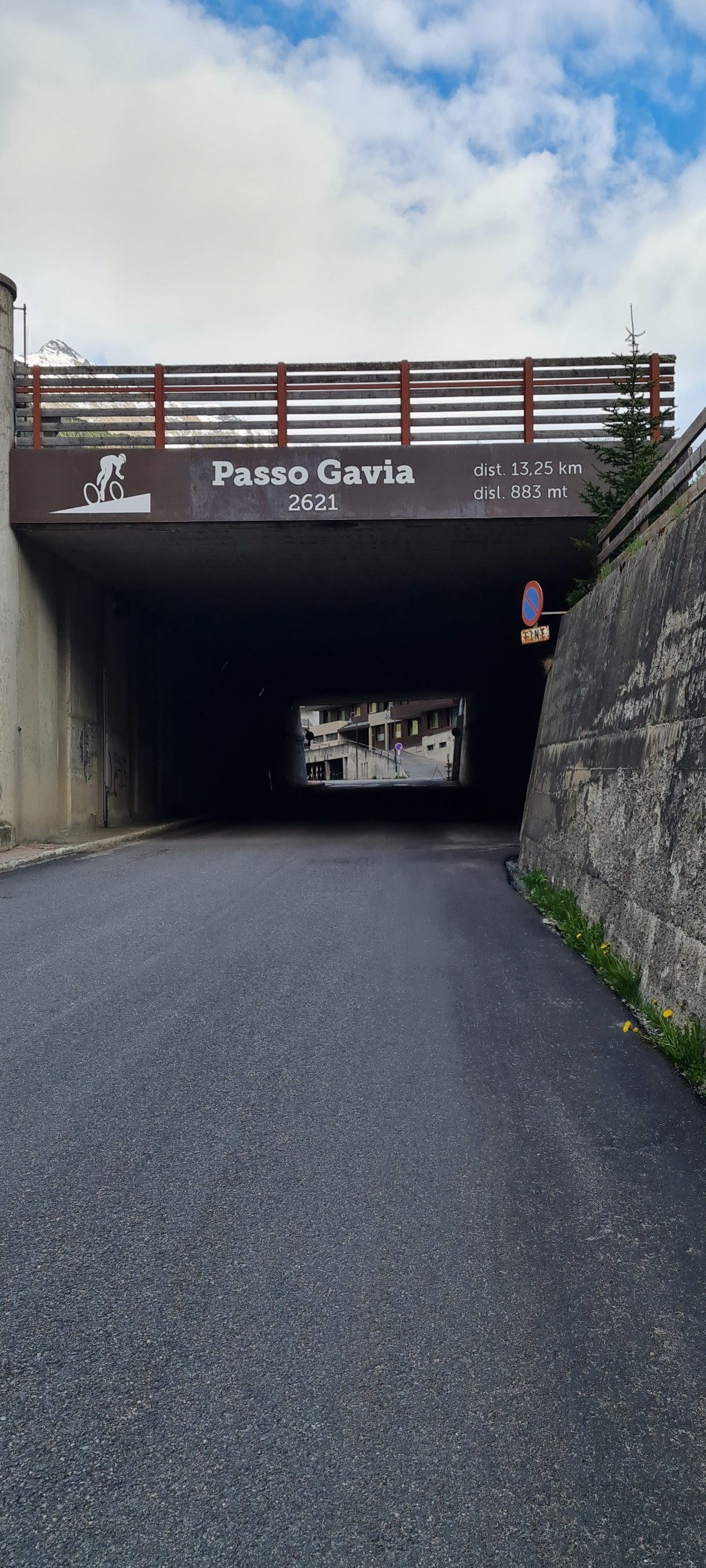
A word of warning: the descent on the other side of the Gavia is very narrow in places. The asphalt is really lousy with holes and cracks. You also pass through an unlit tunnel a few hundred metres long. You can see almost nothing. It is not a luxury to take lamps with you.
Ik vind sommige van de reviews de Gavia geen recht doen. Het klopt dat de eerste 12 kilometer niet de meest spannende zijn. Je fietst die kilometers over een doorgaande weg die niet superdruk is. Stiekem zitten ook hier nog lekkere pittige stukjes in en je ziet hier al af en toe renners pauze nemen.
Na het dorpje rij je het bos in en beginnen de haarspeldbochten. Vanaf hier is de Gavia echt prachtig. De eerste paar kilometers in het bos zijn prima te doen. Onregelmatig, maar goed te doen. Na een kilometer of drie in het bos wordt de onregelmatigheid heftiger. Er zitten echt hele pijnlijke hobbeltjes tussen. Voor het gevoel blijven ze ook maar komen. Ze worden ook steeds steiler en duren langer. Daarmee is de Gavia echt een tegenovergestelde van de Stelvio. De Stelvio is heel constant, de Gavia is dat nooit.
Hoe hoger je komt, hoe meer de omgeving verandert in een maanlandschap met veel rotsen en stromende beekjes. De laatste drie kilometer zijn vrij vlak.
Nog even een waarschuwing: de afdaling aan de andere kant van de Gavia is op plekken erg smal. Het asfalt is echt belabberd met gaten en scheuren. Je komt ook door een onverlichte tunnel van een paar honderd meter lang. Je ziet er nagenoeg niets. Lampjes meenemen is geen overbodige luxe.


Not the best climb from Bormio but worth doing if you want a good prep for Stelvio. The road has lots of traffic all the way up to the top and with poor signage I found it difficult to actually get to the end of it (last 3 km are flat, hence). It gets a bit cold up there so get some arm warmers/wind jacket. The road quality isn’t great in all sections (some 1 km through the two villages are actually cobblestone) so the descent is harder and can be very technical. The views aren’t stunning either in comparison with nearby passes. Sections 19-21 km are hard so pace yourself accordingly.
Climbed from Bormio. From Sancta Catarina the actual climb begins, although I found the start from Bormio after a km or two also a bit of a pause and then continue smoothly. Personally I found the nature much nicer than on the stelvio. The three km at an average of 10% took some doing but it was so nice to be on top. Less traffic than on the stelvio, but despite it being August, it was still chilly at the top.
Beklommen vanuit Bormio. Vanaf Sancta Catarina begint de eigenlijk klim al vond ik de start vanuit Bormio na een km of twee ook even pitten om daarna vlot door te kunnen rijden. Persoonlijk vond ik de natuur vele mooier dan op de stelvio. De drie km aan een gemiddelde van 10% hakte er even op in maar zo leuk om boven te zijn. Minder verkeer dan de stelvio maar ondanks dat het augustus is toch maar frisjes op de top.

I did this climb from bormio but after the stelvio so it felt particularly tough I think if you can do this one alone without the stelvio it is one of the easiest HC climbs but it is not as beautiful as the stelvio
Ik deed deze beklimming uit bormio maar na de stelvio dus dat voelde bijzonder zwaar aan ik denk wel als je alleen deze kan doen zonder stelvio dat dit een van de makkelijkste HC beklimmingen is maar hij is wel niet zo mooi als de stelvio
After two days of cycling larger laps, my legs were not really fresh anymore. (Mortirolo Gavia other side and stelvio Umbrail down and stelvio up) 'in the morning I cycled first to Torri Fraele and then up the Gavia. Here and there it is very uneven. In the first part, there are also parts of 9%. There seems to be a cycle path next to the village so you don't have to bounce on the cobbles. But the parts I tried were gravel, while my Garmin indicated that as an option. One village also has very narrow corridors, so be careful when descending. A large car and bike next to each other is difficult to fit. After the ski village in the forest, it really starts. The last short hairpins are 11%. The steepest parts start when you slowly ride out of the forest. There are quite a few sections of up to 12 metres. Together with some headwind, it was pretty tough for me. But once you get past that, you can blast on to the top. Or in my case, put on a mackintosh and gloves because of the rain and continue to the top. I find the views even more beautiful than the other side of the Gavia. Here and there you can still admire large snow toppings, especially behind the war memorial. But there was also a place with snow on the side. The quality of the road varies. They fixed up some parts so it is beautiful there. The rest is really careful. Especially when descending you have to watch out for holes and cracks.
Na twee dagen grotere ronden gefietst te hebben waren mijn benen niet echt fris meer. (mortirolo Gavia andere kant en stelvio Umbrail af en stelvio op) 's morgens eerst naar Torri Fraele gefietst en toen de Gavia op. Hier en daar is hij erg on regenmatig. In het eerste stuk zitten ook stukken van 9%. Naast de dorpje lijkt ook een fietspad te liggen zodat je niet over de klinkertjes hoeft te stuiteren. Maar de stukken die ik probeerde was gravel. terwijl mijn Garmin dat toch als optie aan gaf. Dus toch maar stuiteren over de klinkertjes in de dorpjes. één dorpje heeft ook hele smalle dorgangen, dus pas op bij afdalen. een grote auto en fiets naast elkaar past lastig. Na het ski dorp in het bos gaat het echt beginnen. De laatste korte haarspelden zijn 11%. Als je langzaam het bos uit rijdt beginnen de steilste stukken. Er zitten aardig wat stukken in van tegen de 12%. Samen met wat tegenwind viel het mij behoorlijk zwaar. Maar als je daar voorbij bent kan je door knallen naar de top. Of in mijn geval regenjas en handschoentjes aan doen ivm regen en door naar de top. De uitzichten vind ik nog mooier als de andere kant van de Gavia. Hier en daar zijn nog grote sneeuw topen te bewonderen, vooral achter het oorlogsmonument. Maar aan de kant was ook nog een plek met sneeuw te vinden. De weg verschild nog al van kwaliteit. Ze hebben een aantal stukken opgeknapt dus daar is het prachtig. De rest is echt oppassen. Vooral bij afdalen moet je goed op de gaten en scheuren letten.

I did this climb during a cycling holiday in Bormio the day after I did the big tour on the Mortirolo on the steep side and this climb, the Gavia, on the south side from Ponte di Legno, also known as the toughest side.
Now, at the top they are both the same, but this side I find the most beautiful in terms of natural beauty and views, more than that, I find this one of the most beautiful climbs in terms of views and natural beauty that I have ever done.
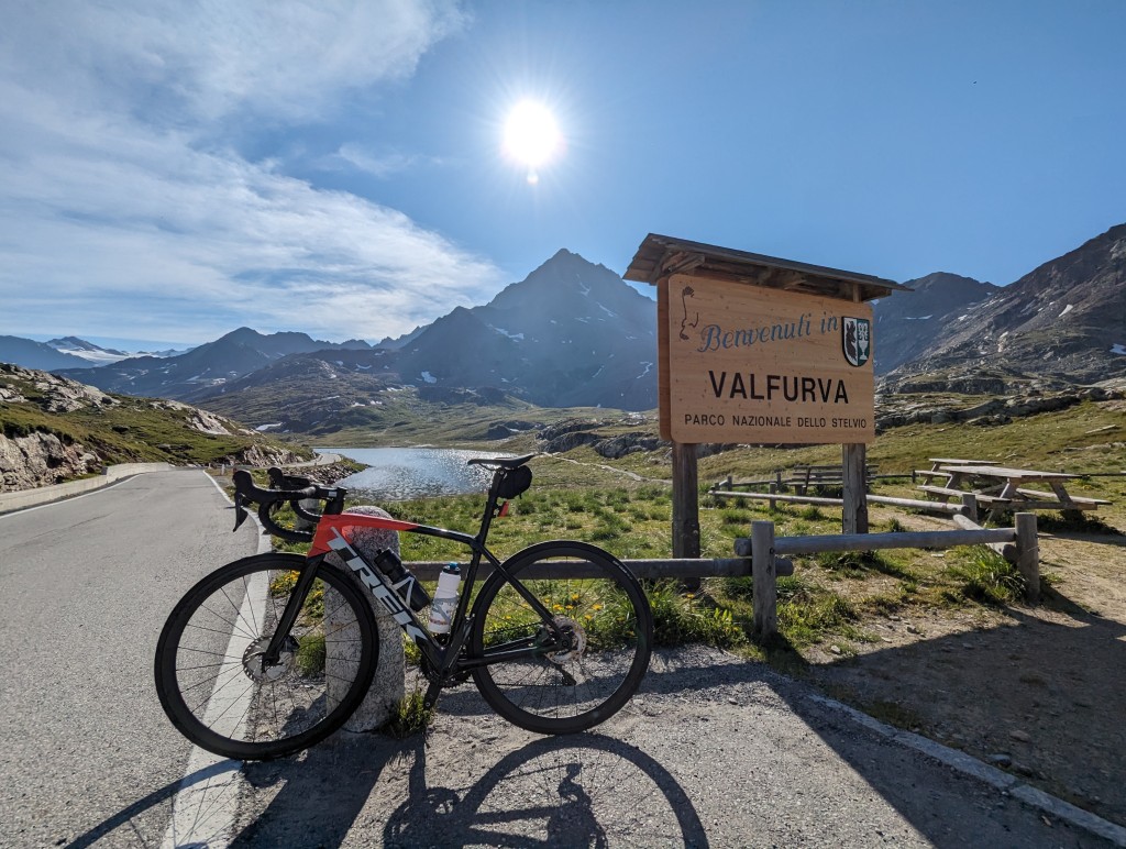
The first few kilometres to the ski village of Santa Caterina are warming up, not very steep, in the village there are some small cobblestones of 5x5cm that are in a very bad state, but that mainly affects the downhill. Ski village is very sleepy and quiet at the beginning of June, and I think also in summer, while there are many hotels and other accommodation options, here you can get bargains for a cheap stay as a cycling holiday. ;-)
Then it really starts, with a zone of hairpin bends over about 8 km.
After about 19 km, at about 6 km from the top, you will see the road rise very high and turn all the way along a large rock formation, beautiful.
If you are a few minutes, and about 1 km, later actually round that rock formation, the worst is almost over, the hairpin bends are passed and the road is back a little less steep.
This is where the most beautiful part of the climb begins, as far as views and natural beauty are concerned.
The Rifugio Bonetta has two signs on a rock with the remaining kilometres to the summit and thus their establishment, more specifically at 4.5 and 2.5 km from the summit. These are the only physical recognition points on this climb of how long you still have to go, otherwise there are no signs every few kilometres or in the hairpin bends that count down (the latter would also be a bit disappointing on this climb). So keep in mind how many kilometres you still have to go or drive with a modern Garmin GPS with climb finder that keeps track of this for you.
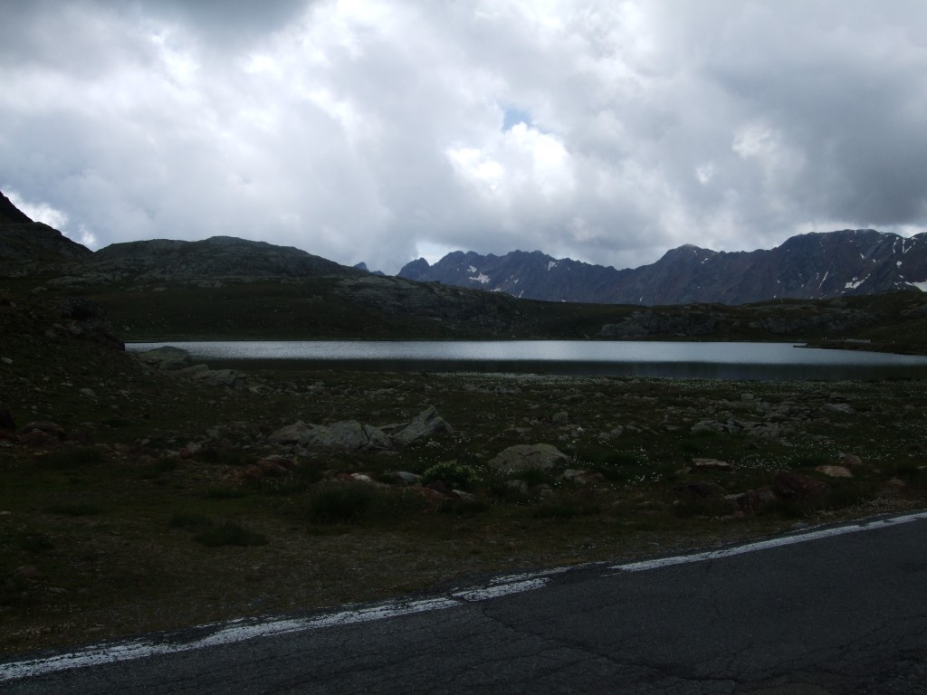
Just after the top there is a war monument on the left with an eagle at the top, a little further you can see the Rifugio Arnaldo Berni and the church nearby. When you have actually reached the top, it is almost over, a little further you will pass the lake Lago Bianco and then the redemption of the top follows.
On the top, there is the Rifugio Bonetta, inside it breathes race, with many photos of riders who came to visit (including Alberto Contador), cycling jerseys against the wall, and framed headlines about the many mythical climbs of the col during the Tour of Italy. In the Rifugio, you can eat something all day long, pasta's for example, and drink a coke or something stronger.
Ik deed deze beklimming tijdens een fietsvakantie in Bormio de dag nadat ik de grote ronde deed over de Mortirolo langs de steile kant en deze klim, De Gavia, langs de zuidkant vanuit Ponte di Legno, tevens bekent als de zwaarste kant.
Nu, boven zijn ze allebei hetzelfde, maar deze zijde vind ik qua natuurpracht en uitzichten de mooist, meer zelfs, ik vind dit één van de mooiste beklimmingen qua uitzichten en natuurpracht die ik al ooit deed.
De eerste kilometers tot voorbij het skidorpje Santa Caterina zijn opwarming, weinig steil, in het dorpje even van die kleine kasseitjes van 5x5cm die er bar slecht bij liggen, maar daar heb je vooral bergaf last van. Skidorpje licht er begin juni, en ik denk ook in de zomer, trouwens zeer slaperig stil bij, terwijl er toch veel hotels en andere logies-mogelijkheden zijn, hier zijn in de zomer koopjes te scoren voor een goedkoop verblijf als fietsvakantie. ;-)
Daarna begint het dus echt, met een zone van haarspeltbochten over ca. 8km.
Na een kilometer of 19, op ca. 6km van de top, zie je de weg zeer hoog oplopen en helemaal langs een grote rotsformatie draaien, prachtig.
Als je een paar minuten, en ongeveer 1 km, later werkelijk die rotsformatie aan het ronden bent is het ergste bijna achter de rug, de haarspeldbochten zijn gepasseerd en de weg wordt terug wat minder stijl.
Hier begint qua uitzichten en natuurpracht het mooiste gedeelte van de klim, tot aan de top rij je langs een soort diepe kloof met aan de overzijde van de kloof mooie hogere ongerepte bergformaties.
De "Rifugio" van de top, de Rifugio Bonetta, heeft op 2 plaatsen op een rots een "reclamebordje" gehangen met de resterende kilometers tot de top en dus hun etablissement, meer bepaald op 4,5 en 2,5km van de top. Dit zijn de enigste fysieke herkenningspunten op deze klim van hoe lang je nog moet, verder niets van bordjes om de kilometer of in de haarspeldbochten die aftellen (dat laatste zou op deze klim ook een beetje tegen vallen). Steek dus goed in je hoofd hoeveel kilometer je nog moet of rij met een moderne Garmin GPS met klimfinder erop die dit voor jou bijhoud.
Even na het ronde van de top is er links een oorlogsmonument met aan de top een adelaar, even verder zie je de iets onder de top gelegen Rifugio Arnaldo Berni en er vlakbij gelegen kerkje al liggen. Als je daar effectief bent is het echt bijna voorbij, even verder kom je nog langs het meer Lago Bianco en dan volgt de verlossing van de top.
Op de top is er dus de Rifugio Bonetta, vanbinnen ademt deze koers, met vele foto's van renners die er nog op bezoek kwamen (oa. Alberto Contador), wielertruitjes tegen de muur, en ingekaderde krantenkoppen over de vele mythische beklimmingen van de col tijdens de Ronde van Italië. In de Rifugio kan je heel de dag door iets eten, pasta's oa., en een cola of iets straffers drinken.


Certainly worth it! I first climbed the Stelvio via Prato, then descended to Bormio. Here I took the climb to the top of the Gavia. The first part to the village of Santa Catarina (more than 10 km) is not so bad. Is really a 'runner' with even flat pieces & pieces of descent. But as soon as you enter Santa Catarina the real climb starts. 13.5 km of suffering! It is difficult to find a good rhythm because it is so irregular. Many steep parts (steeper than Stelvio). The last kilometer is almost flat (when you pass the lake), there is still a strong sprint and you reach the top of the Gavia. Down in Bormio it was (middle of September) 22 degrees, on the summit -2 degrees. Hardly any traffic or other cyclists/moto's, what a difference with the Stelvio. Descent in full fog, was very spooky because there was no other traffic and you saw nothing of the environment, only clouds & fog. TIP: bring your windbreaker, but also front and rear lights. In the descent you will ride through some pitch dark tunnels where you can hardly see anything, life threatening! Road surface also very bad in some parts, but this is really a climb worth the 5 stars!
Zeker de moeite! Heb eerst de Stelvio beklommen via Prato, daarna afgedaald tot Bormio. Hier de klim naar de top van de Gavia genomen. Het eerste deel naar het dorpje Santa Catarina (een dikke 10 km) valt reuze mee. Is echt een 'loper' met zelfs vlakke stukken & stukjes afdaling. Maar vanaf je Santa Catarina binnenrijd begint de echt klim pas. 13.5 km afzien! Het lastige is om hier een degelijk ritme te vinden omdat het zo onregelmatig loopt. Veel steile stroken (steiler dan Stelvio). Laat kilometer is quasi vlak (wanneer je aan het meer passeert), daar nog een stevig sprintje trekken en je bereikt de top van de Gavia. Beneden in Bormio was het (midden september) 22 graden, op de top -2 graden. Amper verkeer of andere fietsers/moto's, wat een verschil met de Stelvio. Afdaling in volle mist, was heel spookachtig omdat er geen ander verkeer was en je zag niets van de omgeving, enkel wolken & mist. TIP: neem sowieso je windjack mee, maar ook voor-en achterlichtjes. In de afdaling rij je door enkele pikdonkere tunnels waar je bijna niets ziet, levensgevaarlijk anders! Wegdek ook heel slecht op sommige stukken, maar dit is wel echt een klim de 5-sterren waard!

My first mountain ever cycled up in 2014. Could I climb?
Well, no idea.
With 6 people we left from Bormio. 25 km to the top.
And yes, I can climb because one after the other companion has to let go and I get to the top as 1st. I felt like Johan van der Velde.
But then came my first descent, no idea how to do it.... First to the top but also last to descend, Hahaha. Not a hero in descending. Top day 🚲.
Mijn eerste berg ooit opgefietst in 2014. Zou ik kunnen klimmen?
Tja, geen idee.
Met 6man vertrokken we vanuit Bormio. 25 km tot de top.
En ja, ik kan klimmen want de ene na de andere metgezel moet lossen en ik kom als 1e boven. Geweldig om mee te maken, voelde me Johan van der Velde.
Maar toen kwam mijn 1e afdaling, geen idee hoe ik dat moest doen.... Als 1e boven maar ook als laatste beneden, Hahaha. Geen held in het afdalen. Topdag 🚲.

Since I had to go back in the afternoon to the airport for my flight back, I left around 6.30 on a Focus Izalco road bike (rented from Bormio Spot-On for €60). Big contrast with the nearby Stelvio: the Gavia is calmer, with equally beautiful nature but less legendary views on hairpins etc. Near the top you bike along the beautiful Lago Bianco. The climb was car free but only from 8.30, so I saw hundreds of bikers going up when I was descending. Check the information from Enjoy Stelvio National Park to see when it will be car free again. Take a jacket. There are no photographers along the road, so no professional souvenir as it is the case on the Stelvio.


Powerful climb, especially on a beautiful sunny day in June with still snow on the top. The start from Bormio is a warmer, but on a warm day it is just that, then it can be very hot in the valley. Fortunately, the temperature drops quickly as we drive up this giant. What a contrast in terms of crowds with that other iconic pass in the area, the Stelvio. At the top it is really enjoyable, especially when the lake starts to thaw after a long winter. It's also best to drive on to the top (if you would descend back to Bormio), because only a few turns over the top there is a fantastic view of a mountain lake and some Alpine giants, definitely worth the extra effort if you would not ride both ways.
Machtige beklimming, zeker op een mooie zonnige dag in juni met nog sneeuw op de top. Het begin vanuit Bormio is nog een opwarmer, maar op een warme dag is het net dat, dan kan het nog erg warm in het dal zijn. Gelukkig daalt de temperatuur snel naarmate we deze reus oprijden. Wat een contrast qua drukte ook met die andere iconische pas uit de buurt, de Stelvio. Bovenaan is het echt genieten qua natuurschoon, zeker als het meer stilaan begint te dooien na een lange winterperiode. Ook kan je best toch even doorrijden op de top (als je terug zou afdalen naar Bormio), want slechts enkele bochten over de top is er een fantastisch zicht op een bergmeer en enkele Alpenreuzen, zeker de extra inspanning waard als je beide kanten niet helemaal zou rijden.


Beautiful, long climb from Bormio, which apart from a few steep sections, goes very well. Much calmer cycling than on the Stelvio. On the top you can enjoy a snack and a drink in a beautiful setting.
Prachtige, lange beklimming vanuit Bormio, die uitgezonderd een paar steile stroken, erg goed loopt. Veel rustiger fietsen dan op de Stelvio. Op de top kan je genieten van een hapje en een drankje in een prachtig decor.

Almost immediately when you leave Bormio the long climb begins. The first part (until the village) is a wide busy road. From the village (which by the way has short stretches with cobblestone roads) start the hairpin bends and the road traffic also decreases very much in volume and you can fully focus on the climb, which you also need because from that point it is not flat anymore until just before the climb. Save your strength until the point where the climb makes a wide circle, there it goes for 2km around 10% average with peaks to 14%. Then it flattens out to 1-3% but the wind has free play on you (so dress well for it). There is a café on the summit itself, not much else.
Overall, the tarmac is moderate throughout the climb, pieces with good and bad tarmac alternate.
Vrijwel direct wanneer je Bormio verlaat begint de lange klim. Het eerste gedeelte (tot het dorp) is een brede drukke autoweg. Vanaf het dorp (die overigens korte stroken met klinker wegen heeft) beginnen de haarspeldbochten en neemt het wegverkeer ook heel erg in volume af en kan je je vol focussen op het klimmen, dat heb je ook nodig want vanaf dat punt wordt het niet meer vlak tot vlak voor de klim. Spaar je krachten tot het punt dat de klim een ruime cirkelbocht maakt, daar gaat hij 2km rond de 10% gem met uitschieters naar 14%. Daarna vlakt hij uit naar 1-3% maar heeft de wind vrij spel op je (dus kleed je goed erop aan). Op de top zelf is een café, verder niet heel veel faceliteiten.
Overall is het asfalt over de hele klim matig, stukken met goed en slecht asfalt wisselen elkaar steeds af.


Climbed of course besides the Stelvio also the Gavia when I stayed for my cycling & walking holiday in Bormio.
First 12 km to St.Caterina rise gradually on fairly busy road with good asphalt, with in center San Nicola passage through typical narrow streets on cobblestones. Then there is less traffic and the steep climb begins via hairpin bends through the pine forest on the mountainside with very irregular gradients.
About 3 kilometers before pass height, above the tree line, it becomes gradually less winding and steep with bad road surface but with fantastic views of the snowy 3000 + mountain peaks on the left side.
Summit at Lago Bianco with mountain hut (provisioning) is 360° natural beauty in the middle of the National Park!
"Easy" side of the Gavia is magnificent, also from Bormeo!!!
Beklom uiteraard naast de Stelvio ook de Gavia toen ik voor mijn fiets & wandelvakantie in Bormio verbleef.
Eerste 12 kilometer tot St.Caterina stijgen geleidelijk over vrij drukke weg met prima asfalt, met onderweg in centrum San Nicola doortocht door typische smalle steegjes op kasseitjes. Nadien is er minder verkeer en begint het steile klimwerk via haarspeldbochten door het naaldwoud de bergflank op met heel onregelmatige hellingsgraden.
Ongeveer 3 kilometer voor pashoogte, boven de boomgrens, wordt het geleidelijk minder bochtig en steil met slecht wegdek doch met fantastisch uitzicht op de besneeuwde 3000+ bergpieken aan de linker zijde.
Top aan Lago Bianco met berghut (bevoorrading) is 360° natuurpracht midden in het Nationaal Park!
"Gemakkelijke" zijde van de Gavia is schitterend, ook vanuit Bormeo!!!

This climb was a real hell ride for me, it drizzled all day and at the top it was cold and there was still snow and ice in June. I can understand why Breukink got cold here during the infamous stage.
Deze klim was een ware helle tocht voor mij, het miezerde de hele dag en boven was het koud en lag er nog sneeuw en ijs in juni. Ik snap wel dat Breukink het hier koud kreeg tijdens de beruchte etappe.


Honestly...
This is not the prettiest side. I only did it myself because I wanted to do the other side of the Mortirolo, but actually. You better take the hard side of the Mortirolo first and then the other side of the Gavia than this one....
Eerlijk...
Dit is niet de mooiste kant. Heb hem zelf ook maar gedaan omdat ik de andere kant van de Mortirolo wilde doen, maar eigenlijk. Neem je beter eerst de zware kant van de Mortirolo en dan de andere kant van de Gavia dan deze...


Beautiful climb, long enough to completely cycle your lights out. It is very irregular so I have never been able to find a good pace. On the profile it does not seem too bad. But there are some tough parts.
Prachtige klim, lang genoeg om je volledig het licht uit te fietsen. Het is heel onregelmatig waardoor ik in ieder geval nooit een goed tempo heb kunnen vinden. Op het profiel lijkt het allemaal nog goed mee te vallen. Maar er zitten er taaie stukken in.

The long side of the Gavia, over 25 kilometers with quite a few turns.
In 2019 the road surface has been renewed on this side, for many a lot safer.
The climb starts in Bormio and goes quietly up through some villages.
Through Santa Catarina di Valfurfa where you can still enjoy the cobblestones. The cobblestones are beautiful but when it's wet you have to be careful when descending.
After the tunnel the high mountains appear again and just outside the village the sign Aperto or chuiso. In winter the pass is closed, so much snow up there that maintaining it is not possible.
The pass is not really a passage for the population in contrast to the Stelvio, so nice and quiet on the road.
The road goes through the forest, the high pines often obstruct the view.
Once through the bends the view opens up and you can see several peaks above 3000 meters, always snow at that altitude. A few more kilometres of pedalling before the last steep part.
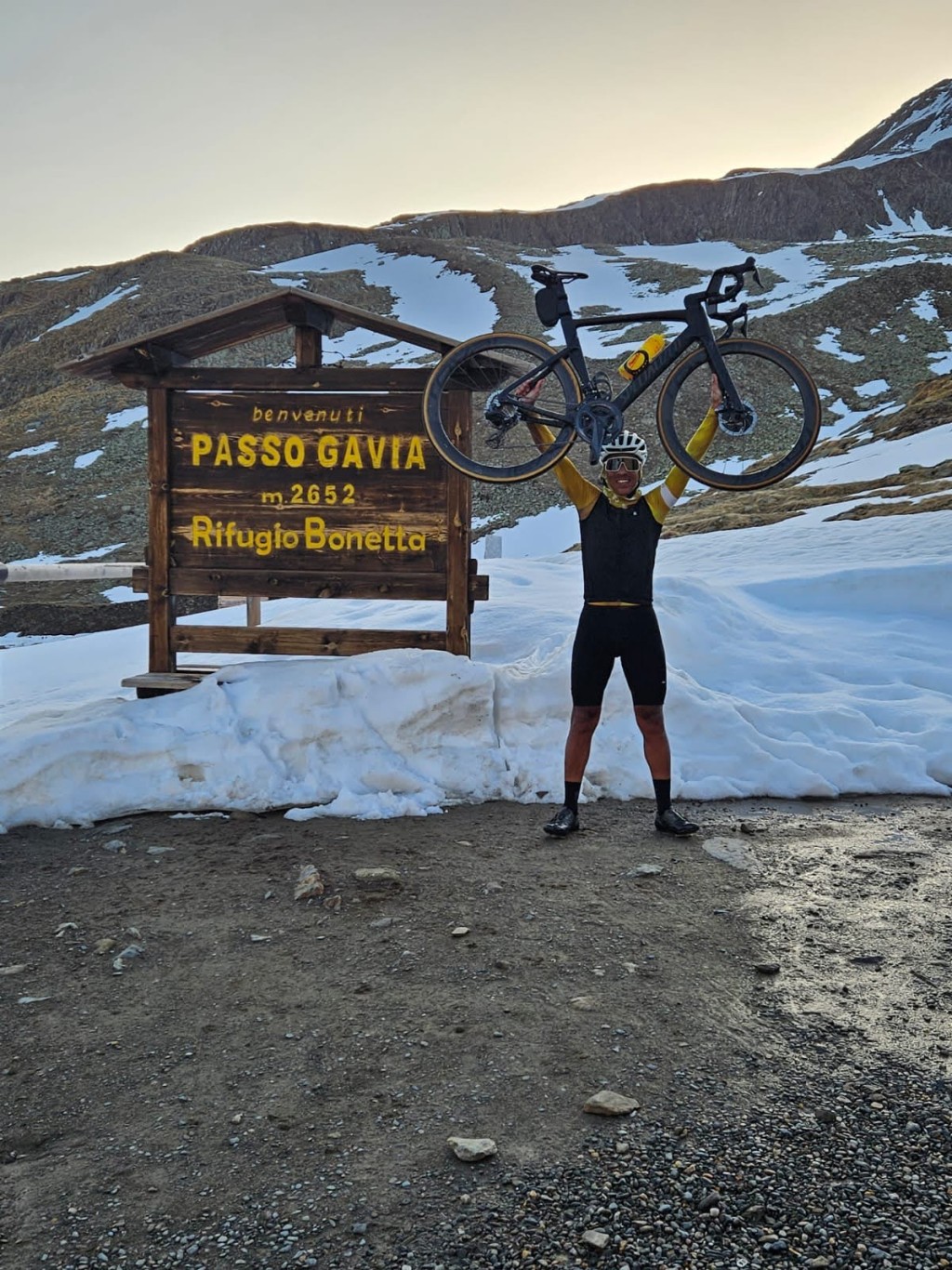
On the plateau it is seemingly flat, your legs soon betray you and hope for a quick end to the climb. The reservoir indicates you're almost there, the albergo on the top gives a warm rest and the unique photo point with "I did the Passo Gavia" is a very modern twist on an ancient point.
The other side is a completely different story, although descending there while the weather is clear is one of the most beautiful nature experiences you can see on a bike.
De lange kant van de Gavia, ruim 25 kilometer met flink wat bochten.
In 2019 is het wegdek vernieuwd aan deze zijde, voor velen een stuk veiliger geworden.
De klim vertrekt in Bormio en gaat door een aantal dorpjes rustig omhoog.
Door Santa Catarina di Valfurfa waar je nog heerlijk over de kasseien kunt dokkeren. Ze liggen er wel mooi bij maar als het nat is opletten in de afdaling.
Na de tunnel doemen de hoge bergen alweer op en net buiten het dorp het bord met Aperto of chuiso. In de winter is de pas dicht, zoveel sneeuw daarboven dat onderhouden geen doen is.
De pas is niet echt een doorgang voor de bevolking in tegenstelling tot de Stelvio, lekker rustig dus onderweg.
De weg loopt door het bos, de hoge dennen belemmeren vaak het uitzicht.
Eenmaal door de bochtenpartij opent het beeld en kijk je naar diverse toppen boven de 3000 meter, altijd sneeuw op die hoogte. Nog een paar kilometer doortrappen voor het laatste steile stuk.
Op het plateau is het ogenschijnlijk vlak, je benen verraden je al snel en hopen op een spoedig einde van de klim. Het stuwmeer geeft aan dat je er bijna bent, de albergo op de top geeft een warme rustplaats en het unieke fotopunt met "I did the Passo Gavia" is een erg moderne twist op een eeuwenoud punt.
De andere kant is een heel ander verhaal, al is afdalen daar terwijl het helder weer is een van de mooiste natuurervaringen die je kunt zien op de fiets.

Climbed from Bormio today. It starts quite heavy before the real climb. From Bormio, you pass through a number of villages where the road is not exactly flat.
When the time comes and you get the first hairpin turn, the enjoyment begins. It is indeed much quieter on the road than the Stelvio. The road quality is considerably lower and you need to watch out, especially in the descent. But what a beautiful climb.
Of course, it is steep now and then, but doable. The last 2 km along the lake and through the roof are great.
And suddenly there is the top.
Coffee and cake at the top. There is 1 restaurant, a bit different from the madhouse on the top of the Stelvio. Unfortunately I took the paper money out of my backpack and apparently you can't use an ATM there.
So we go down without it. But beware
A challenging descent with all those holes and cracks in the road.
But in 1 word: Great!
Geklommen vanuit Bormio vandaag. Het begint al best wel heftig voor de echte beklimming start. Vanuit Bormio kom je door een aantal dorpjes heen waar de weg ook niet bepaald vlak is.
Als het dan zover is en je de eerste haarspeldbocht krijgt gaat t genieten beginnen. Het is inderdaad veel rustiger op de weg dan de stelvio. De weg is wel aanzienlijk minder van kwaliteit en het blijft opletten geblazen, zeker in de afdaling. Maar wat een mooie beklimming.
Tuurlijk, steil zo nu en dan maar prima te doen. De laatste 2 kilometer langs het meertje en door het dak zijn geweldig.
En ineens is daar dan de top.
Koffie en gebak doen op de top. Er is daar 1 restaurant, iets andes dan de gekkeboel op de top van de stelvio. Helaas het papiergeld uit de rugzak gehaald en je kunt daar klaarblijkelijk niet pinnen.
Dan maar zonder naar beneden. Maar let op
Een uitdagende afdaling met al die gaten en scheuren in het wegdek.
Maar in 1 woord: Geweldig !
Cycled this one today, on the mtb. Was easy to do but there are some treacherous parts in terms of climbing and then it is nice that mtb has a few 'panic tooth wheels' left. Road surface is not the best, with racer pay attention, mtb less problems. A great view though!
Vandaag deze gefietst, op de mtb. Was goed te doen alleen zitten er verradelijke stukken in qua klimmen en dan is het fijn dat mtb nog een paar 'paniektandwieltjes' over heeft. Wegdek is niet 'je van het', met racer opletten, mtb minder problemen. Wel een geweldig uitzicht!!
30 years ago the Gavia was a dirt track with grass in the middle... I will never forget.
30 jaar geleden was de Gavia aan de zuidkant nog een onverhard karrepad met gras in het midden... zal ik nooit vergeten
The Gavia is given for 5,8% average and as "easy" by some. The latter is very personal and depends on your experience and personal circumstances.
The climb is long and largely beautiful in terms of nature. hairpin turns interspersed with long stretches. The 5,8% is misleading. Undoubtedly correct from a technical point of view, but flatter parts or even short moments of descending are compensated by steep parts. In combination with the very bad road surface it makes the climb more difficult than it looks on paper.
de Gavia wordt gegeven voor 5,8% gemiddeld en als "makkelijk" door sommigen. Nu is dat laatste erg persoonlijk en sterk afhankelijk van je ervaring en persoonlijke omstandigheden.
De klim is lang en grotendeels schitterend qua natuur. haarspelbochtend afgewisseld met lange stroken. De 5,8% is misleidend. Rekentechnisch ongetwijfeld correct, maar vlakkere stukken of zelfs korte momenten van dalen worden gecompenseerd door steile stukken. In combinatie met het zeer slechte wegdek maakt het de klim lastiger dan hij op papier lijkt.
The first part up to the village of Santa caterina di Valfurva is not beautiful. At the end of the village at the blue sign of the pass starts the forest and from then on it is a very nice route (last 12,5 km). The road surface is very bad in many places. At the top you can sign a petition to ask to renew the road.
A few km below the pass it seems like you are already there. On the left side is a monument for the first world war, a column with an eagle on it. From here on it is almost flat. So you can still accelerate.
Het eerste deel tot het dorp Santa caterina di Valfurva is niet mooi. Aan het einde van het dorp bij het blauwe bord van de Pas begint het bos en vanaf dan is het een hele mooie route (laatste 12,5 km). Het wegdek is op veel plaatsen wel heel erg slecht. Op de top kun je een petitie ondertekenen om te vragen te weg te vernieuwen.
Een paar km onder de pas lijkt het wel of je er al bent. Aan de linkerklant staat een monument voor de eerste wereldoorlog, een zuil met een adelaar erop. Hier moet je dus nog even doorrijden. vanaf dan blijft het wel bijna vlak. Dus kun je nog versnellen.
I have climbed the Gavia from Bormio (24.5 km) 4 times already. I have climbed the Granfondo Stelvio-Santini 4 times in good and bad weather. I usually stay a week in Bormio and on my days off I climb the Stelvio or the Gavia. But the Mortirolo is really a COMMON case (13.4 km long with an average of 10.2%).
Ik heb reeds de Gavia vanuit Bormio (24.5 km) 4x beklommen. Ik vind hem niet zwaar, Alleen de laatste 4 km is een bijzonder slecht wegdek.Ik heb 4x de Granfondo StelvioSantini gereden.Ik heb hem met mooi en slecht weer beklommen. Meestal verblijf ik dan een week in Bormio.Op mijn vrije dagen beklim ik dan de Stelvio of de Gavia. Maar de Mortirolo is echt een GEMEEN geval.(13.4 km lang gemiddeld 10.2 %)
No experience but a question: you say the climb is 24,6 km long, but the graph only goes up to 18 km. Am I missing something, or are you missing a piece? ;-)
Geen ervaring maar een vraag: jullie geven aan dat de klim 24,6 km lang is, maar de grafiek gaat maar tot 18 km. Mis ik iets, of missen jullie een stukje? ;-)